Report on Fernandina (Ecuador) — April 2005

Bulletin of the Global Volcanism Network, vol. 30, no. 4 (April 2005)
Managing Editor: Richard Wunderman.
Fernandina (Ecuador) Lava flows down S flank from circumferential vents near caldera rim
Please cite this report as:
Global Volcanism Program, 2005. Report on Fernandina (Ecuador) (Wunderman, R., ed.). Bulletin of the Global Volcanism Network, 30:4. Smithsonian Institution. https://doi.org/10.5479/si.GVP.BGVN200504-353010
Fernandina
Ecuador
0.37°S, 91.55°W; summit elev. 1476 m
All times are local (unless otherwise noted)
On the morning of 13 May 2005, a new eruption started on uninhabited Fernandina volcano (figure 5). Fernandina last erupted in 1995 (figure 6), and had been quiet and seemingly unchanged when a team from the Ecuadorian Institute of Geophysics (IG) flew over it in late March 2005. On 11 May an M 5.0 earthquake occurred with an epicenter ~ 30 km E of Fernandina's center. Only two other earthquakes have been located by the U.S. Geological Survey (USGS) within 100 km of Fernandina in last 4.5 years (M 4.0 on 23 February 2005 and M 4.6 on 16 April 2005), both having epicenters ~ 70-80 km SE of Fernandina's center. A seismic station, installed by the IG in 1996 on the NE coast of the island, was out of service at the time of eruption.
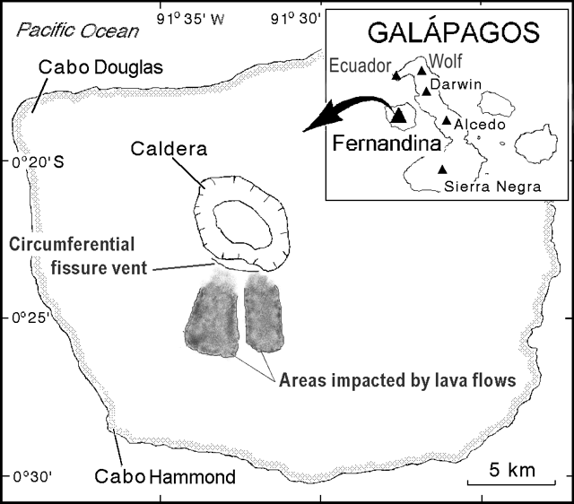 |
Figure 5. Sketch map of Fernandina, showing the conspicuous summit caldera, and indicating the flow fields and circumferential vent area from the 13 May 2005 eruption (as mapped on 14 May by airborne reconnaissance and reported by the Charles Darwin Research Station). Key features include the active circumferential fissure vent and two main areas impacted by lava flows. The eastern area contained lava flows still mobile on 14 May; flows to the W had already cooled by 14 May. On the index map of the Galápagos Islands, the largest island, Isabela, is ~ 130 km long and lies to the E of Fernandina island. "La Cumbre"—Spanish for the summit, peak, or top—has been mistakenly applied to the volcano, apparently because the summit was so labeled on an old map. The island has also been called Narborough. The index map is incomplete in its portrayal of both volcanoes and islands of the archipelago. Revised from BGVN 20:01. |
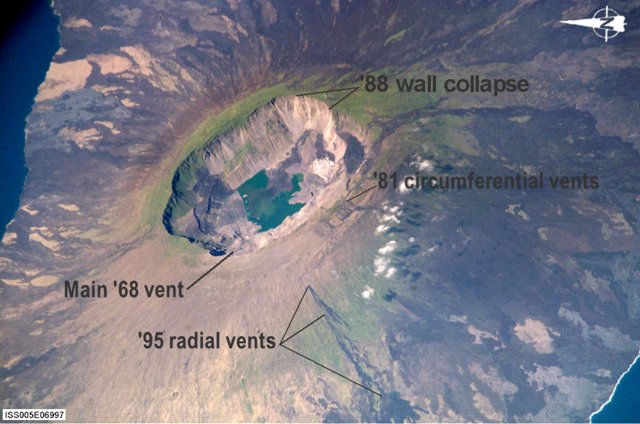 |
Figure 6. A 2002 International Space Station photograph of Fernandina, looking obliquely towards the E (N is towards the left). Labels show key features developed in 1995, 1981, and 1968 eruptions. Note the island's coastline in the lower-right corner and along much of the left margin. Despite the steep walls bounding the 850 m deep, 5 x 6.5 km central caldera, it supports both animal and plant populations. Image ISS05E06997 (Visible Earth v1 ID 18002) with contrast enhanced and labels added by Bulletin editors. |
Galápagos National Park workers in western Galápagos were apparently the first to witness the eruption, and IG technicians recognized it on satellite imagery. The University of Hawaii presents hotspot images on their website. Their GOES data lacked hotspots at 0930, but a clear and strong one had developed on the S flank by 0945. Francisco Dousdebes (of Metropolitan Touring) placed the eruption's start time at 0935. S-flank hotspots were comparatively extensive by 1015. The Washington VAAC issued their first full advisory at 1315. Their notices reported that the W-directed plume rose to ~ 5 km altitude, and the S-directed plume went to 9 km; both were visible as late as 1745 on 13 May, depicting the leading portions of Fernandina' s ash plume more than 200 km from the volcano
An overflight of the eruption on the 13th by the National Park resulted in a report by Patricio Ramón and Hugo Yepes, and the eruption was confirmed by Washington Tapia, director of the Galápagos National Park. That evening, Galápagos resident Greg Estes telephoned Dennis Geist to report that the eruptive source was a "circumferential vent near [the] summit, S side . . . 6 km long with an eruptive zone 50 m across." It was uncertain how this fissure was related to the 1981 eruption site (figure 2 and SEAN 09:03). IG also noted that tephra had fallen on neighboring Isabela Island, in the areas of the volcanoes Wolf and Ecuador (~ 40 km from the vent, figure 1).
At 0537 on the second morning, 14 May, the Washington VAAC reported low level ash/steam not visible in infrared imagery, but at 0746, 1½ hours after sunrise, a plume of ash extended ~ 130 km to the W and was moving at 18 km/hour at 1,800 m elevation. The GOES thermal anomaly was greatly diminished by 0930, and remained low to non-existent until resumption around 1415. That afternoon, an overflight by Godfrey Merlen, Wacho Tapia, and Alan Tye (Charles Darwin Research Station) resulted in the fullest report to date.
They said that although the vent area was obscured by clouds, topography suggested a 4.5 km long fissure vent near the S rim, with activity having progressed from SW (near the first and uppermost flows of the 1995 radial fissure eruption) to the E (figure 1). The lava flows "had begun to pond on the gentler outer skirt of the island," and were then 5.5 km from the coast (~ 5 km from the vents). They thought it unlikely that the flows would reach the sea. A follow-up news report in El Comercio (Quito) quoted Tapia as identifying five flows down the S flank. Only one remained incandescent. At 1745 on 14 May, Washington VAAC reported a plume remaining to the NW, but—lacking detectable ash—they discontinued advisories. Thermal anomalies on the GOES satellite remained strong, however, until the next morning.
The report also noted that, "As on previous eruptions, such as that on Cerro Azul in 1998, lava passing through vegetated areas has caused small fires, but these have not spread far from the lava tongues themselves before going out. Most of the new flows have passed over unvegetated older lava, and damage to Fernandina's vegetation is limited."
The team also flew over Alcedo volcano on Isabela, where Project Isabela staff had reported increased fumarole activity. Steam was rising from the "new" fumarole sites (active since the 1990s) and from the area of sulfur deposits and fumaroles in the southwestern area of the rim, but this activity did not appear unusual.
On 15 May, the GOES thermal anomaly was gone before noon, but returned near midnight (about 2330), over a smaller area, and it remained through sunrise (0615) on 16 May. Small anomalies were visible the next several nights (when contrast with adjacent cold flows was strongest), but there was no obvious evidence of continued feeding of the new flows.
The complex thermal anomalies detected in MODIS satellite imagery (provided by the University of Hawaii), were abundant around the time of eruption. They spread over Fernandina's rim, in some cases in the caldera, and broadly over the S flank. They continued through at least the rest of May.
The Washington VAAC reported that a weak hotspot started 29 May 2005 at 1945 (30 May at 0145 UTC) and a very short narrow plume of ash and gases appeared in multi-spectral imagery at 2145 (30 May at 0345 UTC). No ground confirmation of an eruption was available, and there was a layer of low-level weather cloud over the island. At that time, the plume appeared to dissipate as it moved away at ~ 18 km/hour.
Geological Summary. Fernandina, the most active of Galápagos volcanoes and the one closest to the Galápagos mantle plume, is a basaltic shield volcano with a deep 5 x 6.5 km summit caldera. The volcano displays the classic "overturned soup bowl" profile of Galápagos shield volcanoes. Its caldera is elongated in a NW-SE direction and formed during several episodes of collapse. Circumferential fissures surround the caldera and were instrumental in growth of the volcano. Reporting has been poor in this uninhabited western end of the archipelago, and even a 1981 eruption was not witnessed at the time. In 1968 the caldera floor dropped 350 m following a major explosive eruption. Subsequent eruptions, mostly from vents located on or near the caldera boundary faults, have produced lava flows inside the caldera as well as those in 1995 that reached the coast from a SW-flank vent. Collapse of a nearly 1 km3 section of the east caldera wall during an eruption in 1988 produced a debris-avalanche deposit that covered much of the caldera floor and absorbed the caldera lake.
Information Contacts: Patricio Ramón and Hugo Yepes, Geophysical Institute (IG), Escuela Politécnica Nacional, Apartado 17-01-2759, Quito, Ecuador (URL: http://www.igepn.edu.ec/); Alan Tye, Charles Darwin Research Station, Puerto Ayora, Santa Cruz, Galapagos Islands, Ecuador (URL: http://www.darwinfoundation.org/); Washington Volcanic Ash Advisory Center (VAAC), Satellite Analysis Branch, NOAA/NESDIS E/SP23, NOAA Science Center Room 401, 5200 Auth Road, Camp Springs, MD 20746, USA (URL: http://www.ssd.noaa.gov/); Tom Simkin, Dept. of Mineral Sciences, National Museum of Natural History, Smithsonian Institution, Washington, DC 20013-7012, USA; National Earthquake Information Center, U.S. Geological Survey, Box 25046, DFC, MS 966, Denver, CO 80225-0046, USA (URL: https://earthquake.usgs.gov/); MODIS Thermal Alert System; University of Hawaii and Manoa, 168 East-West Road, Post 602, Honolulu, HI 96822, USA (URL: http://modis.higp.hawaii.edu).