Report on Long Valley (United States) — May 2005

Bulletin of the Global Volcanism Network, vol. 30, no. 5 (May 2005)
Managing Editor: Richard Wunderman.
Long Valley (United States) Minor seismicity throughout 2004
Please cite this report as:
Global Volcanism Program, 2005. Report on Long Valley (United States) (Wunderman, R., ed.). Bulletin of the Global Volcanism Network, 30:5. Smithsonian Institution. https://doi.org/10.5479/si.GVP.BGVN200505-323822
Long Valley
United States
37.7°N, 118.87°W; summit elev. 3390 m
All times are local (unless otherwise noted)
The relative quiescence in Long Valley caldera that began in early 1999 persisted through 2004 according to the U.S. Geological Survey's weekly reports and the 2004 annual summary of the Long Valley Observatory. Those manuscripts provide the basis for this synopsis. Seismicity in the adjacent Sierra Nevada block S of the caldera gradually died away over the same period, although background levels remained somewhat higher than within the caldera.
The resurgent dome continued to undergo minor fluctuations in deformation as reflected in changes in the lengths of baselines onto the dome. Over the past 6 years, the center of the resurgent dome has sustained the roughly 75-cm uplift that accumulated during the recurring unrest from 1979 through 1999.
Seismicity within both the caldera and the Sierra Nevada block to the S remained low through 2004. The two most notable earthquake sequences within the caldera were a minor swarm at the end of January and the first few days of February in the S moat, and a M 3.0 earthquake on 20 September located at the S margin of the caldera just N of Convict Lake. The latter was the first earthquake greater than M 3.0 within the caldera since the cluster of earthquakes on 4 November 2002, events centered beneath the S moat just S of the Highway 395-203 junction. The swarm in early February 2004 was located in the same general area of the S moat, but the epicenters fell along a SW trend in contrast to the WNW trend shown by most earthquake sequences in that area.
Seismicity within the adjacent Sierra Nevada block continued to be somewhat elevated compared to that in the caldera through 2004. The Sierra Nevada activity included about seven earthquakes over M 3, the largest of which was an M 3.7 earthquake on 12 January 2004 located 2 km E of Red Slate Mountain (19 km S of the caldera and 15 km WSW of Tom's Place). Most of the activity remained concentrated in the NNE-trending aftershock zone associated with the three earthquakes over M 5 during June and July 1998 and May 1999.
The most noteworthy seismic activity in the general vicinity of Long Valley caldera during 2004 was the prolonged earthquake swarm in the Adobe Hills centered roughly 20 km E of Mono Lake and 20 km NNE of Long Valley caldera (figure 30). Its onset was marked by a M 2.3 earthquake at 0002 on 18 September, followed by M 3.2 and 4.1 earthquakes at 0007 and 0008, respectively. Activity intensified through mid-afternoon of 18 September, with M 5.5 and M 5.4 earthquakes at 1602 and 1643, respectively. These produced widely felt shaking in the area from Bridgeport to Bishop. Seismicity declined gradually through the remainder of the year and into early 2005. By the end of December 2004, this Adobe Hill swarm had produced well over 1,000 detectable earthquakes including ~ 48 over M 3 and 6 equal or over M 4.
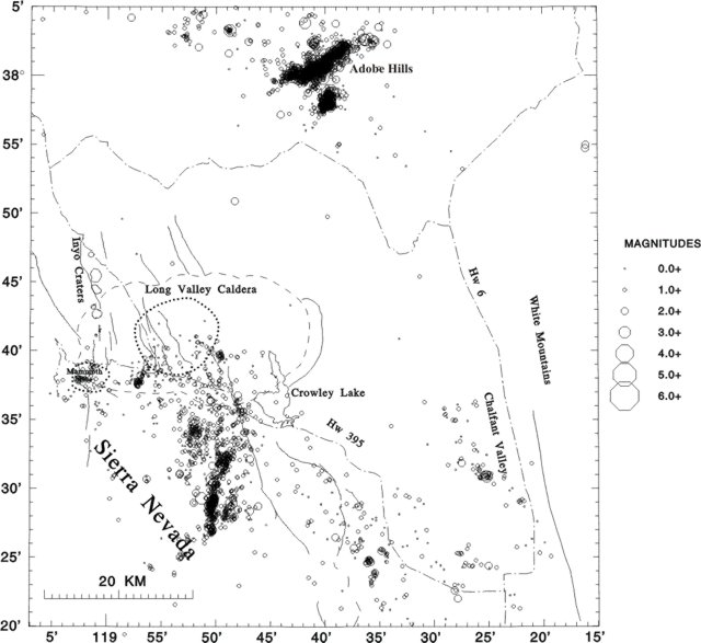 |
Figure 30. All earthquake epicenters detected in the Long Valley region for 2004. Courtesy of U.S. Geological Survey, Long Valley Observatory (2005). |
The mid-crustal long-period (LP) volcanic earthquakes, which began beneath the SW flank of Mammoth Mountain during the 1989 Mammoth Mountain earthquake swarm, continued through 2004 but at a much reduced rate compared with the peak in LP activity from early 1997 through mid-1998.
In early 2005 seismicity was generally minor (up to M 2.5) in and around the caldera. An M 4.2 earthquake occurred S of Long Valley caldera on 13 March 2005 at 1409. The event, which produced light shaking in Mammoth Lakes and Bishop was located in the Sierra Nevada ~ 12 miles SW of Toms Place near Grinnell Lake. It was followed by a series of 18 aftershocks, the largest which were M 2.8 and M 2.3. The last earthquake of similar magnitude in this area occurred in 1999 on 17 May. In addition to the M 4.2 main shock/aftershock sequence, two other significant earthquakes occurred in the Adobe Hills area E of Mono Lake, and a third occurred on 13 March in the Sierra Nevada S of the caldera, near Mount Baldwin. All three had magnitudes under M 2.0. From that time to mid-June 2005, seismicity was generally in the range of M 1-2, with a very few occurring to M 3.
Carbon dioxide (CO2) concentrations measured in the Horseshoe Lake tree-kill area on the S flank of Mammoth Mountain showed no significant changes for 2004 with respect to the past several years. A survey of scattered areas of vegetation die-off and diffuse CO2 flux on the resurgent dome completed in 2004 indicated anomalous CO2 emissions from the kill areas were ~9 metric tons/day (compared with ~ 300 tons/day from Mammoth Mountain). The d13C-CO2 values of the diffuse emissions were similar to values previously reported for CO2 from hot springs and thermal wells around Long Valley, indicating a common source. The areas of elevated CO2 flux tend to be associated with locally elevated soil temperatures. Some of the older areas near the Casa Diablo power plant are likely related to geothermal power production, but development of new areas may reflect a delayed response of the hydrothermal system to the 1997 unrest episode (including an additional 10-cm uplift of the resurgent dome accompanied by intense earthquake swarm activity in the S moat).
Thermal spring discharge in Hot Creek Gorge, which had dropped by about 20% in the last half of 2003, followed by a recovery beginning in January 2004, reached normal discharge values by June 2004. Fluid levels in key monitoring wells continued to decline, with some wells reaching their lowest values since records began in 1985.
Reference. U.S. Geological Survey—Long Valley Observatory, 2005, Long Valley Observatory Quarterly Report, October-December 2004 and Annual Summary for 2004 (URL: http://lvo.wr.usgs.gov/).
Geological Summary. The large 17 x 32 km Long Valley caldera east of the central Sierra Nevada Range formed as a result of the voluminous Bishop Tuff eruption about 760,000 years ago. Resurgent doming in the central part of the caldera occurred shortly afterwards, followed by rhyolitic eruptions from the caldera moat and the eruption of rhyodacite from outer ring fracture vents, ending about 50,000 years ago. During early resurgent doming the caldera was filled with a large lake that left strandlines on the caldera walls and the resurgent dome island; the lake eventually drained through the Owens River Gorge. The caldera remains thermally active, with many hot springs and fumaroles, and has had significant deformation, seismicity, and other unrest in recent years. The late-Pleistocene to Holocene Inyo Craters cut the NW topographic rim of the caldera, and along with Mammoth Mountain on the SW topographic rim, are west of the structural caldera and are chemically and tectonically distinct from the Long Valley magmatic system.
Information Contacts: Long Valley Observatory, U.S. Geological Survey, 345 Middlefield Rd., MS 977, Menlo Park, CA 94025, USA (URL: https://volcanoes.usgs.gov/observatories/calvo/).