Report on Ol Doinyo Lengai (Tanzania) — October 2005

Bulletin of the Global Volcanism Network, vol. 30, no. 10 (October 2005)
Managing Editor: Richard Wunderman.
Ol Doinyo Lengai (Tanzania) Lava continues to spill over crater rim through much of 2005
Please cite this report as:
Global Volcanism Program, 2005. Report on Ol Doinyo Lengai (Tanzania) (Wunderman, R., ed.). Bulletin of the Global Volcanism Network, 30:10. Smithsonian Institution. https://doi.org/10.5479/si.GVP.BGVN200510-222120
Ol Doinyo Lengai
Tanzania
2.764°S, 35.914°E; summit elev. 2962 m
All times are local (unless otherwise noted)
Vigorous eruptive activity was observed in July 2004, and visitors in January 2005 noted that a new crater rim overflow area had developed along the N rim (see report and map in BGVN 30:04). The mountain guide for Martin Haigh reported on 15 May that last lava flows had occurred in March.
Activity during 3-5 July 2005. During 3-5 July 2005 Bernard Marty and others visited the crater to conduct gas sampling. His report follows.
At the time of arrival (0800 on 3 July), sporadic lava flows of the aa type were emitted from a vent at the base of T56B, which was itself disrupted by an explosion, leaving an open cavity about 15 m in diameter. The lava was flowing toward the E overflow, but never reached the crater rim. At about 1130, lava was spilling violently from T58B and flowing towards the E overflow.
Sampling had to be interrupted at T46 due to the risk of a sudden lava flood in the sampling area, a real possibility if the thin W wall of T58B fractured following thermal erosion of the wall by molten lava in the lava lake. One hundred meters S of T46, close to the base of T47, a deep hole ~ 1.5 m diameter and bordered by lava splashes emitted a piercing sound. A pahoehoe lava flow was emitting high temperature gases with no visible steam.
A lava pond, not directly observed but for which bubble explosions were clearly visible, was discharging surges of lava towards the E rim while the adjacent T58C cone, now higher than T58B, was discharging high-velocity gases that occasionally splashed lava. The eruption lasted all day and the following night, with variations from steady-state outpouring with lower degassing, to bursts of large bubbles with enhanced lava emission. By the afternoon of 4 July the lava, which was then overflowing the E slope of the volcano, ignited a bush fire. The lava emission rate was estimated at about 0.3 m3/s, with a speed of ~ 2 m/s in the flat area toward the volcano's flank.
At 0500 on 5 July lava flows suddenly invaded the mountain camp's kitchen area to a depth of one meter. Fortunately no one was hurt, but the episode illustrated that there was no safe area within the N crater.
Activity during 19 July-9 August 2005. During 19 July-9 August a team of observers led by Fred Belton camped in the inactive S crater. They submitted the following report of the active N crater as viewed from the SE crater rim.
Activity during the past year was confined to the crater's central portion. Since its initial violent eruption from a hole in the crater floor on 15 July 2004, T58C has grown to a height of ~ 12 m and is at the time of this report the second highest cone in the crater, tall and narrow with large blocks scattered about the crater floor below, indicating that it has undergone some flank collapses in the preceding months. T49B has grown significantly taller since July 2004 and is the tallest feature in the crater, rising at least 15 m above its base.
T56B, which has remained open to the SE since July 2004, has grown a small cone on its SE flank. The new cone, which has not been named because it is so high on the flank of T56B, is being undermined by a large tunnel. The tunnel begins at the SE base of the small unnamed cone and extends under it to the open vent of T56B. Clearly the tunnel was a recent active feature, and the tunnel entrance appears to be the result of collapse during or after an eruption.
T58B contained a large and deep (10-12 m) open pit, which clearly indicated the presence of past lava-lake activity at two levels. The solid crust of a former lava lake about 4 m below the rim contained a hole near its center that opened into a much deeper chamber. At some point during the night of 4 August this deeper pit was filled by lava so that only the upper level remained.
T57B appeared unchanged from July 2004 until its S half was covered by a thick layer of fused spherical lapilli from a short but powerful eruption of T58C on 20-21 July (figure 85).
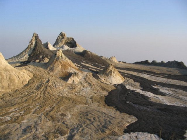 |
Figure 85. At 0100 on 21 July a short but powerful eruption from Ol Doinyo Lengai's T58C vent produced these fresh black lava flows and a lapilli field on the flank of T57B. This view is looking NW. Courtesy of Fred Belton. |
Spatter cones T40, T46, T47, T51, T45, T37, T37B, and the ash cones have continued to be gradually covered by lava flows from the active cone group in the central crater. In particular, T40, which was the primary active cone during much of 1999, is now well on its way to disappearing under the lava. Lava flows from the central cone area have continued to build up the height of the mound in the central crater so that several cones are easily visible from Engare Sero village. T53 (~ 80 m NW of T40) no longer existed. A deep hole in the crater floor, just N of T47 and surrounded by recent pahoehoe flows from T58B, is possibly all that remains of the summit vent of T39. The hole was degassing at a high temperature but did not show any evidence of recent effusive activity. An area in the E part of the crater, which is sheltered by outcroppings and sometimes used by campers, had been covered by a thick flow of slabby pahoehoe lava from T58B. A large amount of vegetation on the E flank of Lengai had also been burned by lava flowing through the E-crater-rim overflow (figure 86). Several locations on the N crater rim had become crossed by small lava flows.
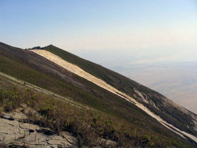 |
Figure 86. The light-colored stripe represents the overflow of recent lavas from Ol Doinyo Lengai down the E flank, as photographed on 7 Aug 2005 from the S crater. The blackened area represents burned vegetation from the bush fire reported by Bernard Marty on 4 July 2005. The lavas, termed natrocarbonatites, turn light colored on the surfaces upon cooling and absorbing moisture. Courtesy of Fred Belton. |
Table 10 shows a multi-year set of measurements of the width of crater rim overflows. The N rim overflow was first measured on 7 August 2005.
Table 10. Measurements of the widths of lava overflowing the crater rim at Ol Doinyo Lengai. The values represent the arc length of the crater rim covered by lava flows on the various dates. Measurements were made by pacing the distance several times and averaging the results. The dashes mean that the overflow had not yet come into existence on the date indicated. The lengths of the flows beyond the crater rim are not shown on this table. Courtesy of Fred Belton and Chris Weber.
| Date | NW overflow width | E overflow width | W overflow width | N overflow width |
| Jul 2000 | 60 m | 38 m | -- | -- |
| 23 Jul 2001 | 106 m | 38 m | -- | -- |
| 05 Aug 2002 | 135 m | 39 m | 12 m | -- |
| 02 Aug 2003 | 135 m | 44 m | 17 m | -- |
| 07 Jul 2004 | 135 m | 44 m | 17 m | -- |
| 16 Jul 2004 | 135 m | 47 m | 17 m | -- |
| 07 Aug 2005 | 135 m | 72 m | 20 m | ~1 m at each of three locations |
Although there was no activity on 19 July, an unobserved eruption may have begun around 2300 on 20 July and probably ended by 0130 on 21 July, according to reports by a camping group in the W portion of the crater floor. The activity reached its peak between 0100 and 0130 and involved strong lava fountains from a vent about halfway up the E side of T58C. The fountains deposited a deep (at least 0.5 m) bed of lapilli around the base and on the S flank and top of cone T57B, and sent pahoehoe and aa flows to the E. One of the flows traveled tens of meters down Lengai's E slopes. The lapilli consisted mostly of hollow spheroids with diameters up to 1.2 cm. Many of the lapilli were fused, and sections of the field broke apart under their own weight, leaving a blocky, fissured surface.
On 21 July at 1511 lava flowed from T58B's active vent during a 12-minute eruption. At 2100 on the same day a third eruption sent strong surges of lava from the same vent and continued throughout the night. Atmospheric clouds prevented detailed observations, but clear conditions at 0500 on 22 July revealed that a large lava channel had formed just E of T58B and had been thermally eroded to a depth of more than one meter. Maximum flow rate during the eruption was estimated to be 0.5 m3/s. The eruption continued until about 1800 and deposited pahoehoe flows over a large part of the SE crater floor.
With the exception of a very minor lava flow from T58C at 1930 on 26 July and the brief (unobserved) appearance of a lava lake in T58B on the night of 4 August, no further activity occurred through 9 August. There were frequent sounds of lava at depth near the base of T58C and inside the open vent of T58B. The lava lake that briefly occupied T58B filled up its deep inner pit and then solidified, leaving a flat surface of new lava about 4 m below the lowest place on the cone's rim. During 4-9 August lava could be heard moving near the surface somewhere inside T58B's vent, but it never became visible. Observations ended at 0800 on 9 August 2005.
Activity during September and October 2005. Kees DeJong reported the following, which was posted on Belton's website: "We climbed Oldonyo Lengai 13 September 2005, arriving at the crater rim [at 0710]. Tourists that had camped in the crater said that eruptions began at midnight (and that there were no eruptions the previous days). Lava kept flowing until about [0846]; we left the crater at [1300] that day."
Photos that Kees made indicated that lava was flowing from about halfway up the side of T48B and across the crater floor toward the W, but that it was not a particularly large eruption. Earlier, probably on 11 September, a small amount of lava flowed down the N flank of T49B and a short distance across the crater floor. Other photos indicated (by comparing specific lava flows on the crater floor with the same lava flows in 7 August photos) a high probability that there were no lava flows at all between 9 August and 11 September. On 19 September Burra Gadiye reported to Roger Mitchell that he had seen no activity that day.
Anatoly Zaytsev climbed on 30 September and reported that they did not see eruptive activity during their visit (between 1100 and 1500). They did see some natrocarbonatite lavas with estimated ages of 2-3 weeks. These were probably the flows from 13 September described above.
Following a visit during 1-3 October, Jaco de Borst reported the following. "During the first of October there was also no activity, only 'smoke' from several cones and cracks. On the second of October there were several 'small' eruptions. In daylight and at night, the cone that was erupting was the biggest and close to the overflow where the trail reaches the crater. Lava only reached the foot of the cone [Belton noted that he was describing T49B]. We left in the morning of 3 October, I think at about 1000. When we left there was no activity... [other] than some noise and 'smoke.' The night eruptions we saw... I think [occurred] about 5 o'clock in the morning [on 3 October]."
Geological Summary. The symmetrical Ol Doinyo Lengai is the only volcano known to have erupted carbonatite tephras and lavas in historical time. The prominent stratovolcano, known to the Maasai as "The Mountain of God," rises abruptly above the broad plain south of Lake Natron in the Gregory Rift Valley. The cone-building stage ended about 15,000 years ago and was followed by periodic ejection of natrocarbonatitic and nephelinite tephra during the Holocene. Historical eruptions have consisted of smaller tephra ejections and emission of numerous natrocarbonatitic lava flows on the floor of the summit crater and occasionally down the upper flanks. The depth and morphology of the northern crater have changed dramatically during the course of historical eruptions, ranging from steep crater walls about 200 m deep in the mid-20th century to shallow platforms mostly filling the crater. Long-term lava effusion in the summit crater beginning in 1983 had by the turn of the century mostly filled the northern crater; by late 1998 lava had begun overflowing the crater rim.
Information Contacts: Christoph Weber, Volcano Expeditions International, Muehlweg 11, 74199 Untergruppenbach, Germany (URL: http://www.v-e-i.de/); Celia Nyamweru, Department of Anthropology, St. Lawrence University, Canton, NY 13617, USA (URL: http://blogs.stlawu.edu/lengai/); Frederick Belton, Developmental Studies Department, PO Box 16, Middle Tennessee State University, Murfreesboro, TN 37132, USA (URL: http://oldoinyolengai.pbworks.com/); Bernard Donth, Waldwiese 5, 66123 Saarbruecken, Germany.