Report on Barren Island (India) — January 2006
Bulletin of the Global Volcanism Network, vol. 31, no. 1 (January 2006)
Managing Editor: Richard Wunderman.
Barren Island (India) November 2005-January 2006 ash emissions, lava flows, and pyroclastics
Please cite this report as:
Global Volcanism Program, 2006. Report on Barren Island (India) (Wunderman, R., ed.). Bulletin of the Global Volcanism Network, 31:1. Smithsonian Institution. https://doi.org/10.5479/si.GVP.BGVN200601-260010
Barren Island
India
12.278°N, 93.858°E; summit elev. 354 m
All times are local (unless otherwise noted)
Activity continued at Barren Island since the volcano's latest eruption that began 28 May 2005 (BGVN 30:05, 30:07, and 30:09). The MODVOLC Alerts Team web site has shown that the MODIS (moderate resolution imaging spectroradiometer) satellite recorded nearly daily thermal anomalies from 26 May 2005 (two days earlier than observed by other means). The thermal anomalies continued through 21 January 2006. In contrast, no thermal anomalies were recorded by satellites in the year prior to 26 May 2005.
D. Chandrasekharam of the Indian Institute of Technology and members of the Indian Coast Guard observed that since 4 November the volcano emitted large volumes of gas and ash emissions, and lava flows had reached the sea. Chandrasekharam stated that the early 2006 activity was more intense than when the eruption began in May 2005. The recent activity was preceded by about ten moderate earthquakes in the region, including M 4.8 and 4.5 events on 3 November.
During 12-15 November 2005, ash plumes emitted from Barren Island were visible on satellite imagery drifting predominantly SSW, but they were no longer visible on 16 November. Ash plumes were visible on satellite imagery on 19 and 20 December at a maximum height of ~ 3.7 km, and during 21-23 December at a maximum height of 4.6 km. Satellite imagery showed a thin ash plume from Barren Island extending WNW during 5-7 January 2006.
Two earthquakes occurred in January 2006. On the 6th, an M 5.4 event struck 137 km E of Barren Island, and on the 21st, an M 5.6 event struck 104 km NNW of the island.
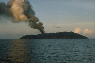
To monitor the ongoing volcanism, a team from the Geological Survey of India, including M.M. Mukherjee, P.C. Bandopadhyay, Tapan Pal, and Sri Prasun Ghosh, approached aboard the Indian Coast Guard Ship C.S. GANGA DEVI during 12-13 January 2006. The party sailed to within 0.8 km of Barren Island and studied the nature of the eruption from shipboard. The eruption resembled fireworks projecting different colors over the crater and on the slope of the cone. Dense clusters of incandescent pyroclasts of various sizes ejected forcefully from the crater mouth "with ballistic trajectories." Apart from eruption from the main crater, a "glow of fire" from the N flank of the cone and thin layers of red hot materials on W slope were observed. The Darwin VAAC reported that ash plumes from Barren Island during 26-27 January rose to ~ 3 km.
Geological Summary. Barren Island, a possession of India in the Andaman Sea about 135 km NE of Port Blair in the Andaman Islands, is the only historically active volcano along the N-S volcanic arc extending between Sumatra and Burma (Myanmar). It is the emergent summit of a volcano that rises from a depth of about 2250 m. The small, uninhabited 3-km-wide island contains a roughly 2-km-wide caldera with walls 250-350 m high. The caldera, which is open to the sea on the west, was created during a major explosive eruption in the late Pleistocene that produced pyroclastic-flow and -surge deposits. Historical eruptions have changed the morphology of the pyroclastic cone in the center of the caldera, and lava flows that fill much of the caldera floor have reached the sea along the western coast.
Information Contacts: D. Chandrasekharam, Indian Institute of Technology, Department of Earth Sciences, Bombay 400076, India (URL: http://www.geos.iitb.ac.in/index.php/dc); Dhanapati Haldar, Presidency College, Kolkata, 4/3K/2 Ho-Chi-Min Sarani, Shakuntala Park, Biren Roy Road (West), Kolkata-700 061, India; Geological Survey of India, 27 Jawaharlal Nehru road, Kolkata 700 016, India (URL: https://www.gsi.gov.in/); Indian Coast Guard, National Stadium Complex, New Delhi 110 001, India (URL: http://indiancoastguard.nic.in/indiancoastguard/); Darwin Volcanic Ash Advisory Center (URL: http://www.bom.gov.au/info/vaac/); MODVOLC Alerts Team, Hawaii Institute of Geophysics and Planetology (HIGP), University of Hawaii at Manoa, 1680 East-West Road, Post 602, Honolulu, HI 96822, USA (URL: http://modis.higp.hawaii.edu/).

