Report on Ubinas (Peru) — May 2006

Bulletin of the Global Volcanism Network, vol. 31, no. 5 (May 2006)
Managing Editor: Richard Wunderman.
Ubinas (Peru) Ash and steam emissions stir hazard and environmental concerns
Please cite this report as:
Global Volcanism Program, 2006. Report on Ubinas (Peru) (Wunderman, R., ed.). Bulletin of the Global Volcanism Network, 31:5. Smithsonian Institution. https://doi.org/10.5479/si.GVP.BGVN200605-354020
Ubinas
Peru
16.345°S, 70.8972°W; summit elev. 5608 m
All times are local (unless otherwise noted)
Ubinas began erupting ash on 25 March 2006 (BGVN 31:03). Randall White from the U.S. Geological Survey (USGS) reported on 1 April that increased fumarolic activity occurred during the end of March. Victor Aguilar from the Universidad de San Agustint, visited the volcano on 31 March. He found strong steam-and-ash emissions occurring. Also, leaves of nearby crops were burned and a sound similar to a jet engine emanated from the vent area. Table 1 gives a summary of some recent plumes. Figure 3 contains an ASTER image of the volcano and surroundings on 8 May 2006.
Table 1. Summary of some recent plume activity from Ubinas. Courtesy of the Buenos Aires VAAC and INGEMMET; satellite imagery courtesy of NASA Earth Observatory.
| Date (time) | Altitude | Drift direction | Comments |
| 06 Apr (1220) | 6.1-9.1 km | -- | Ash absent on satellite imagery |
| 06 Apr (1900) | 6.1-7.3 km | NE | -- |
| 08 Apr | -- | -- | Volcanic activity ceased |
| 09 Apr | 6.1-7.3 km | SW | -- |
| 11 Apr | -- | -- | Volcanic activity ceased |
| 13 Apr | -- | -- | Ash emissions increased, ashfall reached 7 km from volcano |
| 15 Apr | 6.1-9.1 km | -- | Ash cloud |
| 16 Apr | -- | -- | Volcanic activity ceased |
| 18 Apr (0715-1600) | 1-3 km | -- | Continuous emissions of ash and gas |
| 19 Apr | ~3 km | -- | Plume containing ash/lava fragments lasted 6-7 hours |
| 20 Apr-22 Apr | -- | NW, W, SW | Plume reached 60 km from the volcano; traces of ash reached the Arequipa airport. |
| 25 Apr-26 Apr | 0.2-0.7 km | -- | -- |
| 04 May-08 May | ~6.7 km | -- | See fig. 15 |
| 9-11, 13-14 May | 7.3 km (max) | -- | -- |
| 20 May-25 May | 7.3 km (max) | -- | -- |
| 24 May | 6.7 km | E | Plume reported by pilot |
| 25 May | 7 km | NW | -- |
| 30 May | 7.9 km | E | Ash plume seen on satellite imagery |
| 31 May-05 Jun | 7.9 km | N, NE, SE, S | -- |
| 09 Jun-11 Jun | 6.7 km | E, SW | Ash clouds reported by pilots |
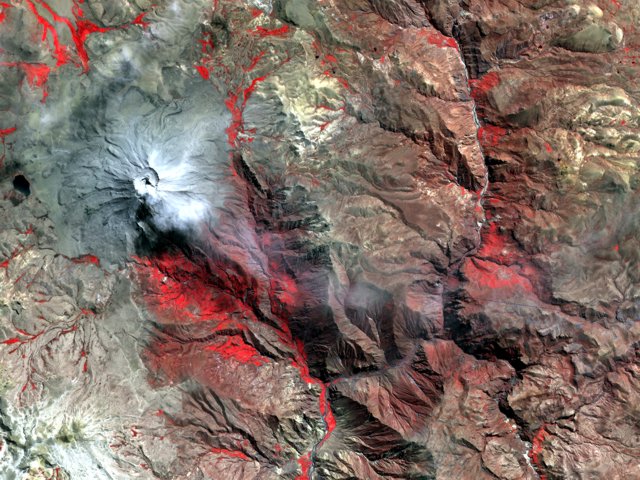 |
Figure 3. A faint white plume rose from the summit of Ubinas on 8 May 2006, when the Advanced Spaceborne Thermal Emission and Reflection Radiometer (ASTER) on NASA's Terra satellite captured this image. Courtesy NASA Earth Observatory. |
The Perú Instituto Geológico Minero y Metalúrgico (INGEMMET) reported that gas and ash were emitted from Ubinas from 27 March to at least 19 April. On 13 April, ash emissions increased noticeably in comparison to the previous days, with ashfall in the villages of Ubinas, Querapi, and Sacuaya, and as far as 7 km from the volcano. Acid rain was also noted in these villages, particularly between 1400 and 1600 hours on 14 April. Explosions on 13 and 14 April were heard in nearby villages. According to a news report on 18 April, however, officials urged residents of the town of Querapi ~ 5 km from the volcano to evacuate.
On 19 April, a lava dome was observed on the crater floor for the first time. It was incandescent, 60 m in diameter, and 4 m high. Explosions were heard as far as 6 km from the volcano and a plume composed of ash and lava fragments rose ~ 3 km above the volcano. Plumes lasted for 6-7 hours and hazard statements suggested significant danger within 4 km of the crater. The Buenos Aires Volcanic Ash Advisory Center (VAAC) released volcanic ash advisory statements during the report period.
According to news reports, as of 19 April at least 1,000 people living N of the volcano suffered respiratory problems, dozens of livestock died and many more were ill after eating ash-covered grass, and water sources were polluted with ash. Dozens of people from Querapi, the town closest to the volcano, began to evacuate on 21 April. On 22 April, officials declared a state of emergency for the area near the volcano and sent aid for evacuees.
During 25 and 26 April, the volume of ash emitted from the volcano decreased significantly. Gas plumes rose between 200 and 700 m above the volcano's caldera. Seismicity during 22-26 April was higher than normal. The Buenos Aires VAAC posted volcanic ash advisories during the report period.
Several thermal anomalies were observed by MODIS/MODVOLC in 2006 at the following local times: 0105 hours, 27 May; 2220 hours, 31 May; 2225 hours, 7 June; 2210 hours, 18 June; and 2235 hours, 30 June. On 3 June, the Alert Level for Ubinas was increased to Orange due to heightened explosive activity. According to a news report, on 5 June, officials in S Perú prepared to evacuate approximately 480 families; approximately 550 families were evacuated on 10 and 11 June. Ubinas emitted a plume of ash and/or steam on 24 June 2006. The Moderate Resolution Imaging Spectroradiometer (MODIS) flying onboard NASA's Aqua satellite showed the plume moving E.
Geological Summary. The truncated appearance of Ubinas, Perú's most active volcano, is a result of a 1.4-km-wide crater at the summit. It is the northernmost of three young volcanoes located along a regional structural lineament about 50 km behind the main volcanic front. The growth and destruction of Ubinas I was followed by construction of Ubinas II beginning in the mid-Pleistocene. The upper slopes of the andesitic-to-rhyolitic Ubinas II stratovolcano are composed primarily of andesitic and trachyandesitic lava flows and steepen to nearly 45°. The steep-walled, 150-m-deep summit crater contains an ash cone with a 500-m-wide funnel-shaped vent that is 200 m deep. Debris-avalanche deposits from the collapse of the SE flank about 3,700 years ago extend 10 km from the volcano. Widespread Plinian pumice-fall deposits include one from about 1,000 years ago. Holocene lava flows are visible on the flanks, but activity documented since the 16th century has consisted of intermittent minor-to-moderate explosive eruptions.
Information Contacts: Randall A. White, USGS/OFDA Volcano Disaster Assistance Program; Victor Aguilar, Universidad de San Agustin, Perú; Buenos Aires Volcanic Ash Advisory Center; Instituto Geológico Minero y Metalúrgico (INGEMMET ? Institution of Mining and Metallurgical Geology); National Aeronautics and Space Administration (NASA) Earth Observer (URL: http://earthobservatory.nasa.gov/NaturalHarards/).