Report on Northern EPR at 9.8°N (Undersea Features) — June 2006
Bulletin of the Global Volcanism Network, vol. 31, no. 6 (June 2006)
Managing Editor: Richard Wunderman.
Northern EPR at 9.8°N (Undersea Features) New submarine lava flows off Central America
Please cite this report as:
Global Volcanism Program, 2006. Report on Northern EPR at 9.8°N (Undersea Features) (Wunderman, R., ed.). Bulletin of the Global Volcanism Network, 31:6. Smithsonian Institution. https://doi.org/10.5479/si.GVP.BGVN200606-334050
Northern EPR at 9.8°N
Undersea Features
9.83°N, 104.3°W; summit elev. -2500 m
All times are local (unless otherwise noted)
Scientists verified a recent seafloor eruption at 9°50'N on the E Pacific Rise (EPR) between ~104°16'00"W and 104°18'58"W (figure 2). This area was visited during cruises of the Research Vessel RV Knorr, 24-26 April 2006, and of the RV New Horizon, 10-17 May 2006. In early April 2006 some ocean bottom seismometers deployed in the area failed to return to the ocean surface when instructed. As a result, scientists suspected that a seafloor eruption may have buried the seismometers with lava (Venture Deep Ocean website).
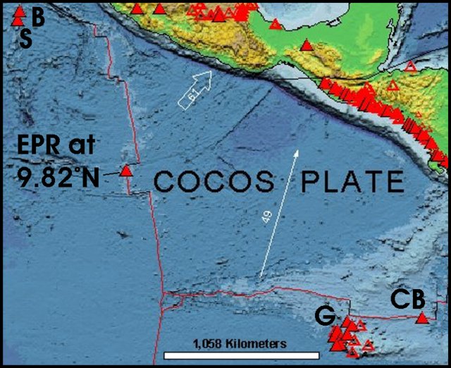 |
Figure 2. Map showing the EPR off Central America. Solid triangles show Holocene volcanoes, and the sub-vertical (N-S) line shows the axis of the EPR (with this volcano at 9.82°E labeled). The Galapagos islands (G) lie in the cluster of known volcanoes there. The Clam Bake (CB) vent zone sits farther E along the Galapagos ridge. The Revillagigedo Islands (Barcena and Socorro) appear at upper left (B and S). Courtesy of the This Dynamic Planet website (Simkin and others, 2006). |
The RV Knorr recovered samples of new seafloor by dredging along the EPR axis in response to this possible eruption. The first seafloor images, collected several weeks later in May 2006 by RV New Horizon, showed fresh and older lavas interspersed along the dredge track (figures 3 and 4). The images also documented young lavas spanning nearly 13 km (between 9°47' and 9°54' N), an area known to cover a significant range in neovolcanic lava compositions.
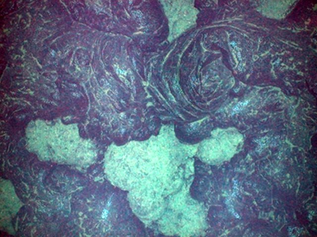 |
Figure 3. Towed-camera view along the crest of the EPR from the New Horizon, 11 May 2006, of a newly erupted (2006?) glassy lobate lava flow overlying older lava. Based on comparisons with images from the submersible Alvin in March 1992, it appeared to be a recent eruption. Cruise scientists tentatively suggested, based on the character of the lava surfaces compared with the underlying lava, that the eruption may have occurred 1 to 6 months earlier. Cast 2, TowCam Run 1, 9°50.2'N, 104°17.5'W, seafloor depth 2,498 m. Courtesy of the Ridge 2000 Program. |
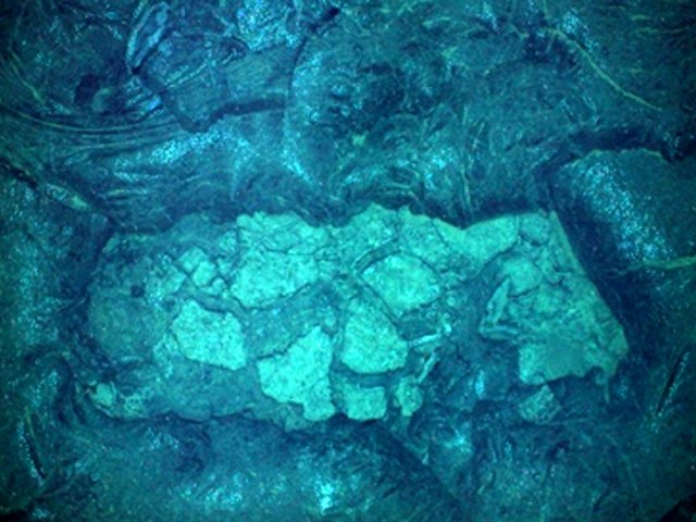 |
Figure 4. Towed-camera view on the EPR from the New Horizon, 11 May 2006, showing a new lava flow framing an exposure of lava that appeared older. The latter (center of frame) was lighter-colored and lobate. Preliminary analysis of the photos suggested that a new lava flow was present at 9°47' N, but perhaps not farther S. In many places (on this and TowCam Run 1) the new flow appeared less than 1 m thick. Cast 4, TowCam Run 2, ~9°47' N, ~104°17' W, seafloor depth ~2,500 m. Courtesy of the Ridge 2000 Program. |
Tolstoy (2006) discussed heightened seismicity detected by ocean-bottom instruments along this part of the EPR. The most pronounced seismicity occurred in the time period of late January 2006. In addition, the U.S. Geological Survey's Earthquake Hazards Program reported an M 5.4 earthquake on the EPR at 2345 UTC on 30 July 2006. It was at 10.06°N, 104.21°W and at a depth of 10 km. Another nearby EPR earthquake, also M 5.4, struck at 0124 UTC on 31 July, centered at 10.01°N, 103.89°W and a depth of ~10 km. Both epicenters were within several kilometers of the eruption site.
K. H. Rubin and Mike Perfit suggested (Rubin and Perfit, 2006) that the new eruption (Bowles and others, 2006) provided an opportunity to define the temporal-spatial evolution of new volcanic seafloor. Such an analysis would provide information not only on how the eruption progressed, but would also form a baseline to subsequent biological, geochemical, and geological observations. According to Rubin and Perfit, sample collection and subsequent radiochemical analysis must be conducted within 1-2 months of the eruptive event because of the 210Po-210Pb radiometric dating method they employ, with a 210Po half-life 138 days. Generation of a detailed surface-age map (with resolution of 2-3 weeks) would require multiple, small, geographically dispersed samples (tens of grams) with known geological context, collected and analyzed within several months after an eruption. Such sampling would be best conducted from a submersible. This dating scheme is not possible more than ~1.5 years after the eruption.
References. Bowles J, Gee, J.S., Kent, D.V., Perfit, M.R., Soule, S.A., and Fornari, D.J., 2006, Paleointensity applications to timing and extent of eruptive activity, 9°-10°N East Pacific Rise: Geochemistry Geophysics Geosystems 7, Q06006, doi:10.1029/2005GC001141.
Haymon, R.M., Fornari, D.J., Edwards, M.H., Carbotte, S., Wright, D., and Macdonald, K.C., 1991, Hydrothermal vent distribution along the E Pacific Rise crest (9°9'-54'N) and its relationship to magmatic and tectonic processes on fast-spreading mid-ocean ridges: Earth and Planetary Science Letters, v. 104, p. 513-534.
Haymon, R.M., Fornari, D.J., Von Damm, K.L., Lilley, M.D., Perfit, M.R., Edmond, J.M., Shanks, W.C., Lutz, R.A., Grebmeier, J.B., Carbotte, S., Wright, D.J., McLaughlin, E., Smith, E., Beedle, N., and Olson, E., 1993, Volcanic eruption of the mid-ocean ridge along the E Pacific Rise crest at 9 degrees 45-52'N; direct submersible observations of seafloor phenomena associated with an eruption event in April, 1991: Earth and Planetary Sciences Letter, v. 119, p. 85-101.
Rubin, K.H, and Perfit, M.R., 2006, High resolution lava surface dating and mapping at 9°50'N EPR: How and Why: Ridge 200 Program, 13 May 2006 discussion paper linked from http://www.ridge2000.org/science/discussion/?m=200604.
Rubin, K.H., Macdougall, J.D., and Perfit, M.R., 1994, 210Po-210Pb dating of recent volcanic eruptions on the seafloor: Nature, v. 368, p. 841-844.
Simkin, T., Tilling, R.I., Vogt, P.R., Kirby, S.H., Kimberly, P., and Stewart, D.B., 2006, This dynamic planet: World map of volcanoes, earthquakes, impact craters, and plate tectonics: U.S. Geological Survey Geologic Investigations Series Map I-2800, 1 two-sided sheet, scale 1:30,000,000.
Smith, M., Perfit, M.R., Fornari, D.J., Ridley, W., Edwards, M.H., Kurras, G., and Von Damm, K.L., 2001, Magmatic processes and segmentation at a fast spreading mid-ocean ridge: detailed investigation of an axial discontinuity on the E Pacific Rise crest at 9°37'N: Geochemistry Geophysics Geosystems, v. 2, no. 10, doi:10.1029/2000GC000134.Tolstoy, M., 22 May 2006, First look at seismic data from EPR 9° 50' N Ocean Bottom Seismometers: Results from Knorr OBS turn-around: Ridge 2000 Program (http://www.ridge2000.org/science/tcs/epr06activity.html).
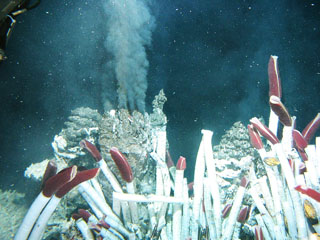
Geological Summary. A series of dives with the submersible Alvin in 1991 on the East Pacific Rise at about 9°50'N detected evidence for a very recent, possibly ongoing, eruption. Hot-vent animal communities documented during November-December 1989 had been buried by fresh basaltic lava flows, and the scorched soft tissues of partially buried biota had not yet attracted bottom scavengers. Fresh black smoker chimneys and new lava flows were present. This site is south of the Clipperton Fracture Zone at a depth of about 2,500 m, and about 1,000 km SW of Acapulco, México; the south end of the Lamont Seamount chain is about 10 km NW. This is also the location where lava flows previously estimated as being less than roughly 50 years old had been found. Later dating using very short half-life radionuclides from dredged samples confirmed the young age of the eruption and indicated that another eruptive event had taken place in late 1991 and early 1992. An eruption in 2005-2006 produced lava flows that entrapped previously emplaced seismometers.
Information Contacts: K.H. Rubin, School of Ocean and Earth Science and Technology, University of Hawai'i at Manoa, 1680 East-West Road, Honolulu, HI 96822, USA; Michael R. Perfit, Dept of Geological Sciences, Univ of Florida, 365 Williamson Hall, Gainesville, FL 32606, USA; Ridge 2000 Program, EPR 9N Integrated Studies Site (ISS) Latest Updates, 22 May 2006; Venture Deep Ocean, website by the Education & Outreach team of Ridge 2000 Program Office, Scripps Institution of Oceanography, University of California, San Diego, 9500 Gilman Drive, La Jolla, CA 92093-0225, USA; U.S. Geological Survey Earthquake Hazards Program (URL: http://earthquake.usgs.gov/).