Report on Montagu Island (United Kingdom) — November 2006
Bulletin of the Global Volcanism Network, vol. 31, no. 11 (November 2006)
Managing Editor: Richard Wunderman.
Montagu Island (United Kingdom) Explosive and possible effusive activity continues in December 2006
Please cite this report as:
Global Volcanism Program, 2006. Report on Montagu Island (United Kingdom) (Wunderman, R., ed.). Bulletin of the Global Volcanism Network, 31:11. Smithsonian Institution. https://doi.org/10.5479/si.GVP.BGVN200611-390081
Montagu Island
United Kingdom
58.445°S, 26.374°W; summit elev. 1370 m
All times are local (unless otherwise noted)
Matt Patrick provided three new ASTER images showing Montagu on 28 October 2006. The ASTER VNIR image (Bands 3-2-1, RGB) (figure 17) depicts Montagu in a state similar to that observed in other ASTER images of the eruption. The persistent ash plume has covered the NE quadrant of the island in dark tephra, while the lava field extending from the summit vent to the coast is clearly visible. The lava delta, extending to a distance of ~ 3.5 km from the vent, first formed during the September-October 2005 eruptive phase and remains intact (BGVN 30:11). It is unclear if any new lava flows erupted since that time have extended as far.
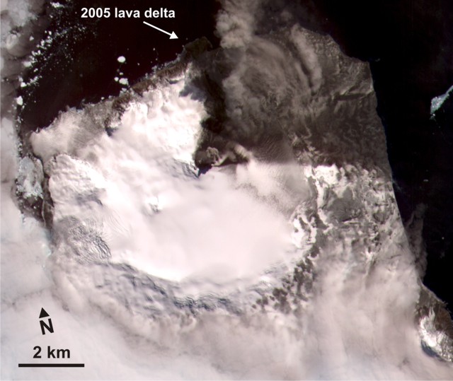 |
Figure 17. An image of Montagu Island captured on 28 October 2006 by ASTER VNIR. Courtesy of NASA with interpretation in text by Matt Patrick, Michigan Technological University. |
ASTER (Advanced Spaceborne Thermal Emission and Reflection Radiometer) is an imaging radiometer that consists of three distinct telescope subsystems: near infrared (VNIR), shortwave infrared (SWIR), and thermal infrared (TIR). These have the following spectral ranges, number of bands, and spatial resolutions: VNIR (spectral range, 0.5-0.9 ?m in three bands; spatial resolution, 15 m); SWIR (spectral range 1.6-2.5 ?m in six bands, spatial resolution 30 m); TIR (8-12 ?m in five bands; spatial resolution, 90 m).
Patrick noted that the ASTER TIR (Band 14; thermal infrared wavelength 10.95-11.65 ?m) and SWIR (Band 9; short-wave infrared wavelength 2.360-2.430 ?m) images (figure 18) may show a new lava flow reaching ~ 1.5 km NE from the summit. An elongated section of warm pixels in the TIR corresponds to a feature which appears to have a faint outline of anomalous pixels in the SWIR, possibly reflecting a new flow.
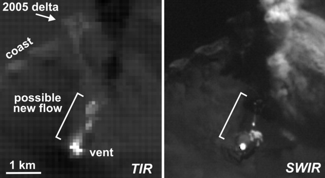 |
Figure 18. Two image of Montagu Island captured on 28 October 2006 by ASTER TIR and SWIR, which show slightly different features than seen on the previous (ASTER VNIR) image, and may disclose a new lava flow. Courtesy of NASA with interpretation by Matt Patrick. |
Geological Summary. The largest of the South Sandwich Islands, Montagu consists of a massive shield volcano cut by a 6-km-wide ice-filled summit caldera. The summit of the 11 x 15 km island rises about 3,000 m from the sea floor between Bristol and Saunders Islands. Around 90% of the island is ice-covered; glaciers extending to the sea typically form vertical ice cliffs. The name Mount Belinda has been applied both to the high point at the southern end of the summit caldera and to the young central cone. Mount Oceanite, an isolated peak at the SE tip of the island, was the source of lava flows exposed at Mathias Point and Allen Point. There was no record of Holocene activity until MODIS satellite data, beginning in late 2001, revealed thermal anomalies consistent with lava lake activity. Apparent plumes and single anomalous pixels were observed intermittently on AVHRR images from March 1995 to February 1998, possibly indicating earlier volcanic activity.
Information Contacts: Matthew Patrick, Dept. of Geological and Mining Engineering and Sciences, Michigan Technological University, 1400 Townsend Drive, Houghton, MI 49931, USA; Hawai'i Institute of Geophysics and Planetology (HIGP) Thermal Alerts Team, School of Ocean and Earth Science and Technology (SOEST), Univ. of Hawai'i, 2525 Correa Road, Honolulu, HI 96822, USA (URL: http://modis.higp.hawaii.edu/).