Report on Karangetang (Indonesia) — May 2007

Bulletin of the Global Volcanism Network, vol. 32, no. 5 (May 2007)
Managing Editor: Edward Venzke.
Karangetang (Indonesia) Frequent activity since 2004, including lava emission and pyroclastic flows
Please cite this report as:
Global Volcanism Program, 2007. Report on Karangetang (Indonesia) (Venzke, E., ed.). Bulletin of the Global Volcanism Network, 32:5. Smithsonian Institution. https://doi.org/10.5479/si.GVP.BGVN200705-267020
Karangetang
Indonesia
2.781°N, 125.407°E; summit elev. 1797 m
All times are local (unless otherwise noted)
Since the end of an eruptive period in October 2003 (BGVN 28:11 and 29:03), recent activity has been centered at Crater I (S crater) and Crater II (N crater), of the five summit craters (figure 5). Activity since late 2003 has included ash plumes, lava flows, lava avalanches, and pyroclastic flows. There have been five periods when thermal anomalies were detected in MODIS satellite data from January 2004 through March 2007 (figure 6). However, the gaps between such episodes may in part be caused by clouds obscuring the summit, so they cannot be correlated to eruptive episodes. Intermittent reports made available by the Center of Volcanology and Geological Hazard Mitigation (CVGHM) since June 2004 provide additional observations and seismic data, and sometimes note eruptive activity during periods of gaps in MODIS thermal anomalies. These reports are also not provided on a regular basis, and the lack of reports for a time period does not necessarily indicate a lack of activity.
 |
Figure 5. Topographic map and N-S profiles of Karangetang showing the five summit craters. Craters I (KI) and II (KII) are currently active. The topographic base map is from 1962; roughly N-S profiles are from 1992 (top) and July 2001 (bottom), showing the changes caused by dome growth. Courtesy of CVGHM. |
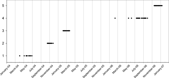 |
Figure 6. Plot showing days with MODIS thermal anomalies during January 2004-February 2007. Scale indicates the five arbitrary thermal anomaly periods, and does not reflect anomaly magnitudes. Eruptive activity was also reported on some occasions during gaps in thermal anomalies. Compiled from MODIS/HIGP data. |
Activity during April-November 2004. After a single thermal anomaly on 5 April 2004, another nine anomalies were seen in MODIS data during 5 May to 29 June. Observations provided by the CVGHM indicated continuing activity during this period. Reports from 31 May onward through 29 August noted that activity was centered at Crater I, but visual observations were often prevented by fog. On clear days white plumes rose 100-400 m above the crater rim. Incandescent glow seen at night reached 10-25 m above the summit. At Crater II, diffuse white plumes reached 25-50 m above the rim. During the three weeks of 9-29 August the reports also included observations of incandescent material and sounds of lava avalanches. Ten avalanche signals were recorded the week of 16-22 August. Shallow B-type volcanic earthquakes also increased significantly (table 12).
Table 12. Seismicity at Karangetang during 24 May-29 August 2004. Courtesy of CVGHM.
| Date | Deep volcanic (A-type) | Shallow volcanic (B-type) | Multiphase |
| 24 May-30 May 2004 | 4 | 12 | 5 |
| 31 May-06 Jun 2004 | 10 | 35 | 7 |
| 07 Jun-13 Jun 2004 | 22 | 22 | 4 |
| 14 Jun-20 Jun 2004 | 11 | 22 | 4 |
| 21 Jun-27 Jun 2004 | 45 | 49 | 13 |
| 28 Jun-04 Jul 2004 | 6 | 7 | 3 |
| 05 Jul-11 Jul 2004 | 16 | 30 | 1 |
| 12 Jul-18 Jul 2004 | 11 | 29 | 3 |
| 19 Jul-25 Jul 2004 | 11 | 18 | 16 |
| 26 Jul-01 Aug 2004 | 14 | 12 | 2 |
| 02 Aug-08 Aug 2004 | 12 | 75 | 11 |
| 09 Aug-15 Aug 2004 | 86 | 259 | 60 |
| 16 Aug-22 Aug 2004 | 10 | 153 | 74 |
| 23 Aug-29 Aug 2004 | 9 | 56 | 68 |
Between 16 October and 26 November 2004, thermal anomalies were again frequent. On 25 October the hazard status was raised due to increasing volcanism over the previous two days. A larger area of incandescence was noted at the summit, and a lava flow descended 800 m. No other reports of observations were available between September and November 2004.
Activity during January-March 2005. Thermal anomalies reappeared in MODIS satellite data on 6 February 2005, and continued to be detected on an almost daily basis through 24 March. CVGHM reports noted lava avalanches starting on 3 January 2005, accompanied by booming noises. During 24-30 January white gas plumes were emitted 50 m above both craters, and a 10- m-high glare was observed at night inside the plume from Crater II. Lava avalanches since 26 January originated from the lava-flow front, moving 750-1,200 m towards the Beha Barat River, 750-2,200 m towards the Batu Awang River, and 1,750 m towards the Kahetang River.
Lava avalanches in the first half of February had run-out distances of 1,250 m down the Beha River drainage, 700 m down the Batu Awang, 1,750 m down the Kahetang, and 1,200 m down the Nanitu. Incandescent material during this period was ejected ~25 m into the air and fell back into the crater. On 16 February, a lava flow advanced 600 m from the crater towards the Nanitu River. A pyroclastic flow later that evening from the lava front traveled 3.4 km and reached the sea, ~4 km from the summit. Lava avalanches from flow-fronts continued into late February toward the Beha, Kahetang, Batu Awang, and Nanitu drainages to distances of 500-1,200 m. These avalanche events produced continuous booming sounds and also "glowing bursts" to heights of 10-25 m. Gas emitted from Crater I rose 50-200 m, and a glare could be seen inside the gas column to heights of 25-75 m. Crater II also produced gas emissions 50-150 m high.
No additional reports are available until a mid-April 2005 report indicated that the volcano was still at a Level III hazard status. During clear weather over 2-9 May, a 400-m-high white gas plume rose from Crater I; there was a 25-m-high glare inside it. Meanwhile, Crater II emitted a white gas plume as high as 100 m. Due to the continuing possibility of pyroclastic avalanches and lahars during the rainy season, residents were not allowed within 2 km of the edge of the lava flow. On 30 May, based on a pilot observation, the Darwin VAAC reported ash at a height below 3 km drifting E; however ash was not visible on satellite imagery.
Activity during August-December 2005. The Darwin VAAC again issued an ash advisory on 2 August regarding a plume to an altitude of 4.6 km. This ash cloud, which continued through 4 August without significant interruptions, was occasionally discernable on both MTSAT and NOAA -12 satellites. Between 26 September and 16 October CVGHM reports again noted white gas rising 200-250 m from Crater I with a 25-m-high glare at the bottom of the gas column, and a 150-m gas emissions from Batukole crater. Tremor continued during 30 November-13 December 2005, but no other activity was described. Karangetang remained at Alert Level 3.
Activity during July-September 2006. Single MODIS thermal anomalies were seen on 11 February 2006, 18 May, and 8 June. Hot spots were then seen almost daily during 13 July-30 September. The Darwin VAAC noted a small eruption on 3 July 2006 with an ash plume to an altitude of 3.7 km observed on satellite imagery. On 12 July, lava flows were moving E toward the Kahetang and Batu Awang rivers, reaching a maximum distance of 2 km. White emissions rose 600 m above the crater. Having previously been lowered, the hazard status was raised from 2 to 3 on 13 July, and then to Alert Level 4 on 22 July due to increased eruptive activity. Lava flows 1.8 km from the vent were observed on 20 July moving E toward the Kahetang and Batu Awang rivers, were 2 km long towards the Keting River, and 400 m S towards the Bahembang River.
On 21 July, a pyroclastic flow from the upper S flank traveled 2.5 km toward the Batu Awang River and was followed by lava flows that traveled toward the Keting and E towards the Kahetang rivers, reaching a maximum runout distance of 2 km. On 22 July, Electronic Distance Measurement equipment indicated deformation measurements indicative of a bulge of about 3-5 mm. Diffuse white smoke was seen at a height of ~350 m above the summit. Lava flows traveled a maximum distance of ~2.3 km towards the Keting and S towards the Bahembang rivers during 22-23 and 25 July.
On 1 and 2 August 2006, lava flows traveled up to 500 m E toward the Batu Awang river and 300-750 m S towards the Keting River and white plumes reached heights of 50-300 m above the summit. Incandescent rockfalls originating from the summit and termini of the lava flows traveled 500-1,500 m E toward the Kahetang and Batu Awang rivers, S towards the Keting River, and occasionally 500 m S towards the Batang River. During 3-4 August, lava flows traveled up to 500 m E toward the Batu Awang river and 100-750 m S towards the Keting. During 7-13 August, lava flows again advanced E toward the Batu Awang river. Incandescent rockfalls originating from ends of the lava flows were also observed.
Activity from mid-August through September 2006 was relatively uneventful. The Darwin VAAC reported an ash cloud on 11 September. On 24 November the Darwin VAAC, reported an eruption that produced a small ash plume observed on satellite imagery that reached an altitude of 3 km.
Activity during November 2006-April 2007. After about six weeks without being detected, thermal anomalies were again frequently seen from 17 November through 11 January 2007. On 14 February the Alert Level was reduced from 3 to 2. Tremor events were recorded at a rate of 52/day over the previous two months, but had not increased since the 21 July 2006 pyroclastic flows, and earthquakes were shallow. Crater I continued to emit a thin trace of white gas 100-300 m above the crater rim. Emissions from Crater II rose to 50-250 m, with occasional incandescence up to 50 m.
Karangetang was relatively quiet until 28 March when a gas cloud was observed up to 100 m above the crater rim. According to a news article in the Jakarta Post, increased activity starting on 26 March led to the emission of "hot clouds" over the next two days. Based on satellite imagery and analysis from the US Geological Survey, the CVGHM reported that sometime between mid-March and 6 April the lava dome in the northern crater had collapsed and was replaced by a new dome ~40 m in diameter. A MODIS thermal anomaly was detected on 3 April. During 23-29 April only dense white plumes were observed from Crater II.
Geological Summary. Karangetang (Api Siau) volcano lies at the northern end of the island of Siau, about 125 km NNE of the NE-most point of Sulawesi. The stratovolcano contains five summit craters along a N-S line. It is one of Indonesia's most active volcanoes, with more than 40 eruptions recorded since 1675 and many additional small eruptions that were not documented (Neumann van Padang, 1951). Twentieth-century eruptions have included frequent explosive activity sometimes accompanied by pyroclastic flows and lahars. Lava dome growth has occurred in the summit craters; collapse of lava flow fronts have produced pyroclastic flows.
Information Contacts: Center of Volcanology and Geological Hazard Mitigation (CVGHM), Jalan Diponegoro 57, Bandung 40122, Indonesia (URL: http://vsi.esdm.go.id/); Hawai'i Institute of Geophysics and Planetology (HIGP) Hot Spots System, University of Hawai'i, 2525 Correa Road, Honolulu, HI 96822, USA (URL: http://modis.higp.hawaii.edu/); Darwin Volcanic Ash Advisory Centre (VAAC), Bureau of Meteorology, Northern Territory Regional Office, PO Box 40050, Casuarina, Northern Territory 0811, Australia (URL: http://www.bom.gov.au/info/vaac/); Jakarta Post, Indonesia (URL: http://www.thejakartapost.com/).