Report on Raung (Indonesia) — September 2007
Bulletin of the Global Volcanism Network, vol. 32, no. 9 (September 2007)
Managing Editor: Richard Wunderman.
Raung (Indonesia) Uncertain July 2007 ash plume; August 2007 ash plume seen for several hours
Please cite this report as:
Global Volcanism Program, 2007. Report on Raung (Indonesia) (Wunderman, R., ed.). Bulletin of the Global Volcanism Network, 32:9. Smithsonian Institution. https://doi.org/10.5479/si.GVP.BGVN200709-263340
Raung
Indonesia
8.119°S, 114.056°E; summit elev. 3260 m
All times are local (unless otherwise noted)
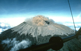
Nine anomalous Moderate Resolution Imaging Spectroradiometer (MODIS) observations of volcanic hot spots were reported during 3 June-8 October 2004 (BGVN 30:01). No other activity was reported from Raung until 26 July 2007. That day the Darwin Volcanic Ash Advisory Center (VAAC) indicated that a pilot had observed an ash plume, possibly from Raung, which their ash advisory reported as follows: "AIREP [an aircraft observation] reported ash cloud observed over volcano on eastern tip of Java. Plume up to 5000 feet [~ 1.2 km] above summit. Volcano assumed to be Raung. Ash not seen on latest satellite pass due to cloud."
Darwin VAAC produced five reports in reference to a Raung ash plume emitted on 26 August 2007. Visible wavelength imagery on MT SAT disclosed a plume at FL 150 (15,000 feet, or 4.6 km altitude) drifting E at ~ 10 km/hr (at 0430 UTC on 26 August). The last view of the cloud was reported at 0833 UTC, still at the same altitude and moving at the same velocity. That plume rose to an altitude of 1.5 km. Ash was not visible on satellite imagery. The Darwin VAAC reported that satellite imagery had detected an ash plume from Raung during 26-27 August that rose to an altitude of 4.6 km and drifted E.
Geological Summary. Raung, one of Java's most active volcanoes, is a massive stratovolcano in easternmost Java that was constructed SW of the rim of Ijen caldera. The unvegetated summit is truncated by a dramatic steep-walled, 2-km-wide caldera that has been the site of frequent historical eruptions. A prehistoric collapse of Gunung Gadung on the W flank produced a large debris avalanche that traveled 79 km, reaching nearly to the Indian Ocean. Raung contains several centers constructed along a NE-SW line, with Gunung Suket and Gunung Gadung stratovolcanoes being located to the NE and W, respectively.
Information Contacts: Darwin Volcanic Ash Advisory Center, Bureau of Meteorology, Northern Territory Regional Office, PO Box 40050, Casuarina, Northern Territory 0811, Australia (URL: http://www.bom.gov.au/info/vaac/).

