Report on Gamkonora (Indonesia) — October 2007
Bulletin of the Global Volcanism Network, vol. 32, no. 10 (October 2007)
Managing Editor: Richard Wunderman.
Gamkonora (Indonesia) Phreatic eruptions in July 2007 create ash plumes and ashfall in nearby villages
Please cite this report as:
Global Volcanism Program, 2007. Report on Gamkonora (Indonesia) (Wunderman, R., ed.). Bulletin of the Global Volcanism Network, 32:10. Smithsonian Institution. https://doi.org/10.5479/si.GVP.BGVN200710-268040
Gamkonora
Indonesia
1.38°N, 127.53°E; summit elev. 1635 m
All times are local (unless otherwise noted)
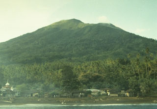
According to the Center of Volcanology and Geological Hazard Mitigation (CVGHM), on 8 July 2007 a phreatic eruption from Gamkonora (figure 1) produced a white-gray ash plume that rose to an altitude of 1.8 km. The plume drifted N, and ashfall was reported from villages as far as 7 km downwind. The Alert Level was raised to 2 (on a scale of 1-4). The only two previous Bulletin reports on Gamkonora, in 1981 and 1987 (SEAN 06:07 and 12:04), described eruptions generating plumes that rose to less than 1 km above the vent.
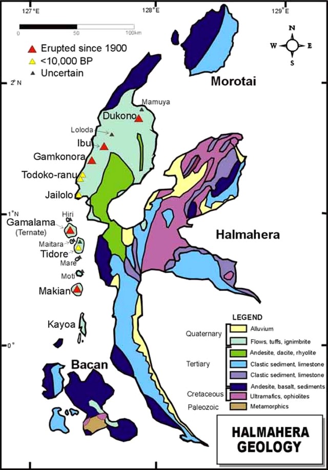 |
Figure 1. Geology of the island of Halmahera showing the locations of Dukono, Gamkonora, and Gamalama volcanoes. The map distinguishes volcanoes into three groups based on the time of last eruption: erupted since 1900; erupted earlier than 1900 but within 10,000 years before present (BP); and uncertain date of eruption. Courtesy of Volcano World (map by Grant Davey and Dan Olberg, PT Nusa Halmahera Minerals). |
On 9 July 2007, seismic activity increased and, according to the Darwin Volcanic Ash Advisory Centre (VAAC), eruption plumes rose to altitudes of 2.1-2.6 km. The Alert Level was raised to 3. Later that day, ash plumes rose to an altitude of 5.6 km, and the Alert Level was raised to 4. On 9 July, the Hawai'i Institute of Geophysics and Planetology (HIGP) Thermal Alerts System identified a 1-pixel thermal anomaly recorded by the MODIS Terra satellite. This was the only thermal anomaly measured for this volcano since the beginning of 2007. No further thermal anomalies were measured from 10 July to 27 November 2007.
During 9-10 July, incandescent material was propelled 5-50 m above the crater and intermittently showered the flank. On 10 July, booming noises were followed by ash plumes that rose to an altitude of 4.1 km. About 8,400 people were evacuated from villages within an 8 km radius of the volcano.
Visual observations of ash plumes during 12-15 July were hindered by cloud cover. On 16 July, the Alert Level was lowered from 4 to 3 due to a significant decrease in seismic activity, a decline in ash-plume altitudes, and the absence of summit incandescence. On 24 July CVGHM further lowered the Alert Level to 2 based on visual observations and another decrease in seismicity. Later, during 16-23 July, when breaks in inclement weather took place, observers saw white plumes rising to altitudes of 5.6 km. Available CVGHM reports issued through late 2007 did not disclose further events. According to Saut Simatupang, the head of Indonesia's Volcanological Survey, local flights on surrounding islands were affected. Longer distance domestic flights to eastern Indonesia were not disrupted.
Geological Summary. The shifting of eruption centers on Gamkonora, the highest peak of Halmahera, has produced an elongated series of summit craters along a N-S trending rift. Youthful-looking lava flows originate near the cones of Gunung Alon and Popolojo, south of Gamkonora. Since its first recorded eruption in the 16th century, typical activity has been small-to-moderate explosive eruptions. Its largest recorded eruption, in 1673, was accompanied by tsunamis that inundated villages.
Information Contacts: Center of Volcanology and Geological Hazard Mitigation (CVGHM), Jalan Diponegoro 57, Bandung 40122, Indonesia (URL: http://vsi.esdm.go.id/); Darwin Volcanic Ash Advisory Centre (VAAC), Bureau of Meteorology, Northern Territory Regional Office, PO Box 40050, Casuarina, NT 0811, Australia (URL: http://www.bom.gov.au/info/vaac/); Hawai'i Institute of Geophysics and Planetology (HIGP) Thermal Alerts System, School of Ocean and Earth Science and Technology (SOEST), University of Hawai'i, 2525 Correa Road, Honolulu, HI 96822, USA (URL: http://modis.higp.hawaii.edu/); Volcano World (URL: http://volcano.oregonstate.edu/).