Report on Poas (Costa Rica) — December 2007
Bulletin of the Global Volcanism Network, vol. 32, no. 12 (December 2007)
Managing Editor: Richard Wunderman.
Poas (Costa Rica) Small phreatic eruption from crater lake on 13 January 2008
Please cite this report as:
Global Volcanism Program, 2007. Report on Poas (Costa Rica) (Wunderman, R., ed.). Bulletin of the Global Volcanism Network, 32:12. Smithsonian Institution. https://doi.org/10.5479/si.GVP.BGVN200712-345040
Poas
Costa Rica
10.2°N, 84.233°W; summit elev. 2697 m
All times are local (unless otherwise noted)
A small phreatic eruption took place from the crater lake at Poás (figure 83) on 13 January 2008. Various changes such as the loss of fumaroles and minor mass wasting have also occurred at the intracrater dome. The 13 January eruption was described in a report by Eliecer Duarte of the Observatorio Vulcanologico Sismologica de Costa Rica-Universidad Nacional (OVSICORI-UNA). Our previous report discussed September 2006-September 2007 and noted hydrothermal variations and a minor phreatic eruption (BGVN 32:09).
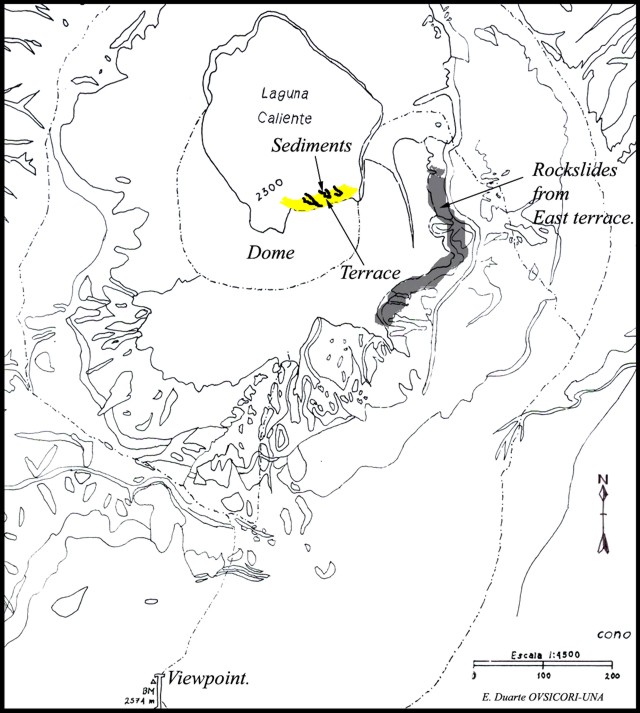 |
Figure 83. Topographic map of Poás and environs emphasizing the crater lake, scene of a 13 January phreatic eruption. Note the dome and the area labeled 'terrace' on its margin. Map by E. Duarte, OVSICORI-UNA. |
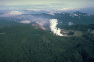
A small phreatic eruption occurred at 0900 on 13 January from the hot, acidic Laguna Caliente. Carlos Cordero, a park ranger who witnessed the event, indicated that the event ejected water and sediments from the lake's center to a height of ~ 200 m. This material mainly fell back into the lake, changing its color from a dark green to an intense white (figure 84). The event was also seen by a group of tourists who watched from the main viewpoint ~ 1 km S of the lake. The eye-witness report emphasized the calm conditions of the lake and dome before the eruption.
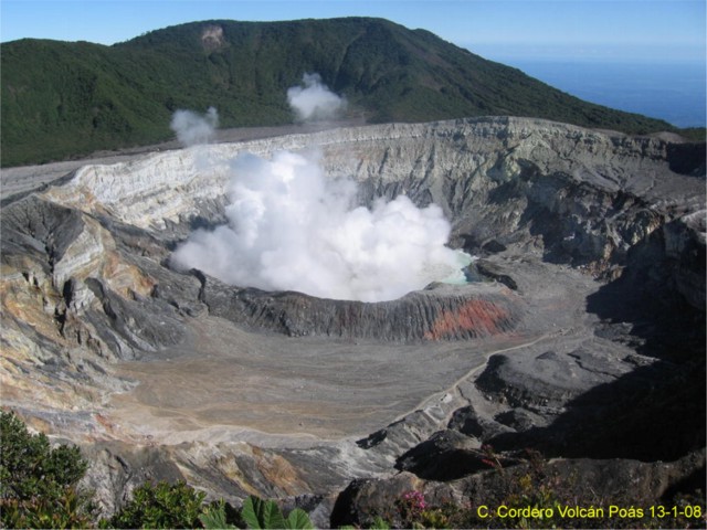 |
Figure 84. A picture of the active crater of Poás taken a short time after the phreatic eruption had ended and the main column had collapsed on 13 January 2008. The dome is in front of the steam-covered lake. The shot was captured by park ranger Carlos Cordero who stood at the main viewpoint S of the lake. Courtesy of OVSICORI-UNA. |
Post-eruption inspection of the crater by OVSICORI staff revealed that the explosion left a 1.5-m-wide band of sediment up to 10 cm thick along the entire rim of the lake (figure 85). Some sediment also extended about 8 m from the shore at the S rim, near the terrace of the dome. The deposits, clearly debris from the lake bottom, included many shining crystals; larger clasts were absent. After the expulsion, water flowing back into the lake seemingly scoured or removed some sediment.
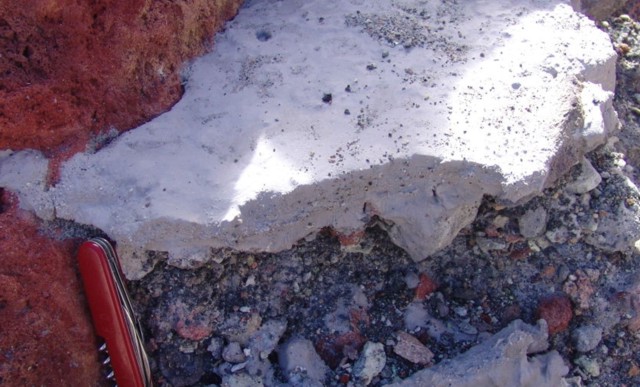 |
Figure 85. A remnant of the dried and solidified sediments expelled during the 13 January eruption at Poás. The sediments, fine grained and light in color, appeared to have come directly from the bottom of the crater lake. Note pocket knife for scale. Courtesy of OVSICORI-UNA. |
During a visit of OVSICORI staff, the lake's color changed over about a 3-hour period as a result of gas expulsion. The rapid degassing of thick columns of toxic gases obscured visibility of the other side of the lake. Compared to measurements at the end of November 2007, the lake's temperature had dropped (to 45°C) and the water level had risen 1.5 m.
The OVSICORI's staff also found a small landslide (8 x 20 m) on the dome's N face (figure 86). They described the landslide as a chaotic deposit of heavily altered angular blocks in a gray matrix that had been altered by hydrothermal activity. A slurry of yellowish materials reached the edge of the lake. Based on field evidence, the team concluded that the small landslide took place immediately after the emission of sediments.
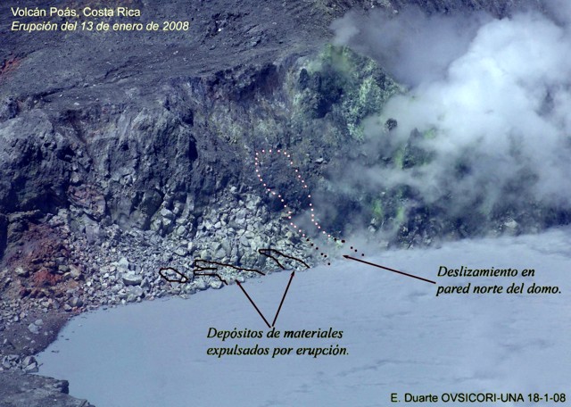 |
Figure 86. This 18 January photo of the crater lake, shoreline, and adjacent dome at Poás, indicates the location of several small areas where 13 January deposits still remained. In addition, a small portion of the dome had detached and moved downslope in a minor landslide that reached the lake. Courtesy of OVSICORI-UNA. |
Figure 87 shows a photo of the dome's steep E cliff face. Fumaroles had recently ceased emerging. Cracks and crevices on top of that terrace were also rapidly widening as joint blocks detach.
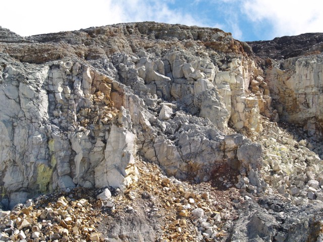 |
Figure 87. A photo of the E wall of the dome at Poás, a zone of active slope failure. In this area previously active springs and fumaroles had recently disappeared leaving only native sulfur deposits at the mouth of former fumaroles. At the foot of the cliff lies a terrace of debris from mass wasting. Courtesy of OVSICORI-UNA. |
Geological Summary. The broad vegetated edifice of Poás, one of the most active volcanoes of Costa Rica, contains three craters along a N-S line. The frequently visited multi-hued summit crater lakes of the basaltic-to-dacitic volcano are easily accessible by vehicle from the nearby capital city of San José. A N-S-trending fissure cutting the complex stratovolcano extends to the lower N flank, where it has produced the Congo stratovolcano and several lake-filled maars. The southernmost of the two summit crater lakes, Botos, last erupted about 7,500 years ago. The more prominent geothermally heated northern lake, Laguna Caliente, is one of the world's most acidic natural lakes, with a pH of near zero. It has been the site of frequent phreatic and phreatomagmatic eruptions since an eruption was reported in 1828. Eruptions often include geyser-like ejections of crater-lake water.
Information Contacts: E. Duarte and E. Fernández, Observatorio Vulcanologico Sismologica de Costa Rica-Universidad Nacional (OVSICORI-UNA), Apartado 86-3000, Heredia, Costa Rica (URL: http://www.ovsicori.una.ac.cr/).