Report on Ol Doinyo Lengai (Tanzania) — February 2008

Bulletin of the Global Volcanism Network, vol. 33, no. 2 (February 2008)
Managing Editor: Richard Wunderman.
Ol Doinyo Lengai (Tanzania) Explosive eruptions of December 2007-March 2008; hazard warnings
Please cite this report as:
Global Volcanism Program, 2008. Report on Ol Doinyo Lengai (Tanzania) (Wunderman, R., ed.). Bulletin of the Global Volcanism Network, 33:2. Smithsonian Institution. https://doi.org/10.5479/si.GVP.BGVN200802-222120
Ol Doinyo Lengai
Tanzania
2.764°S, 35.914°E; summit elev. 2962 m
All times are local (unless otherwise noted)
The previous report on Ol Doinyo Lengai (BGVN 32:11), often simply called Lengai, summarized seismicity and energetic ash emissions during 2007. The development of a single large cone with a prominent venting crater significantly changed the crater morphology.
This report discusses field observations by various individuals during December 2007 through March 2008. The reports and photos from visitors provided by Frederick Belton on his website form the source for much of which follows. Table 16 summarizes the observations from December 2007 through March 2008.
Table 16. Summary of visitors to Ol Doinyo Lengai and their brief observations (from a climb, aerial overflight, or flank) from December 2007 through 26 March 2008. Observations for 2007 were reported in BGVN 32:11. Most of this list is courtesy of Frederick Belton.
| Date | Observer | Observation Location | Brief Observations |
| 07 Dec 2007 | Joerg Keller, Jurgis Klaudius | Climb | Geological samples collected; ash eruption with plumes rising to several thousand meters above volcano (see text). |
| 25 Dec 2007 | Jens Fissenebert, Paul Johns | Aerial/Climb | Observations of crater from helicopter and ground (see text). |
| 31 Dec 2007 | Raphael Wolf | Climb | Volcano "shook 3 times as my guide and I were climbing;" vent of new cinder cone steaming. |
| 06 Jan 2008 | Paul Johns | Aerial/Climb | Helicopter landed in S crater, group walked to summit; eruption during flight to crater and 15 minutes after they left; large rocks (bombs?) had been thrown into the S crater. |
| 14 Jan 2008 | Vegard Laukhammer | Climb | Experienced eruption (see text). |
| 17 Jan-21 Jan 2008 | Tom Pfeiffer, group from Volcano Discovery | Climb | See text. |
| 18 Jan 2008 | Thomas Holden | Climb | New climbing route on the SE described. |
| 19 Jan 2008 | Bernhard Donth, Thomas Schulmeister, William (Maasai) | Climb | Occasional rain of fine gray ash and small white pebbles during ascent; small ash jets from the active crater. |
| 04 Feb 2008 | Michael Dalton-Smith | Flank | See text. |
| 12 Feb 2008 | Michel Picard | Aerial | Photographed a dark ash cloud. |
| 13 Feb 2008 | Walt Bilofsky | Aerial | Ash rising from summit crater. |
| 15 Feb 2008 | Gerrit Jan Plaisier, Rob Alakaposa | Aerial | Plume over Lengai to altitude of 11 km. |
| 15 Feb 2008 | Benoit Wangermez (pilot) | Aerial | Summit crater heavily cloaked in fresh ash; ash cloud rising from crater; movie of eruption on Celia Nyamweru's website. |
| 20 Feb 2008 | Nigel D'Aubrey | Aerial | Plume over Lengai. |
| 21 Feb 2008 | KLM pilot | Aerial | Eruption. |
| 24 Feb 2008 | Claude Humbert | Climb | Party of 11 people attempted to climb the S side, but terminated the climb about half-way up due to eruption. |
| 27 Feb 2008 | Reported to Michael Dalton-Smith | Flank | Eruptions getting stronger; observed from Gol, massive cloud. |
| 27-28 Feb 2008 | Flight crew | Aerial | Ash emissions at 1030 and 1200 on 27 Feb and 0530 on 28 Feb; ash cloud moved SW and dissipated. |
| 27-28 Feb 2008 | Dave Rhys | Flank | Eruptions observed from the Serengeti Plain and Ngorongoro Crater 3; single ash plumes rose rapidly following each eruption (none continuous) and dispersed S (thin ash coating on leaves around the rim of Ngorongoro crater). |
| 01 Mar 2008 | Max Voight | Aerial | Photo of ash plume rising. |
| late Feb 2008, 1-2 Mar 2008 | Benoit Wilhelmi (pilot) | Aerial | Photos of ash plumes. |
| 03 Mar-05 Mar 2008 | Tony Drummond-Murray | Flank | Massive eruptions (see text). |
| 05 Mar 2008 | Benoit Wilhelmi (pilot) | Aerial | Plume to altitude of ~15.2 km. |
| 11 Mar-12 Mar 2008 | Benoit Wilhelmi (pilot) | Aerial | Strong ash eruption (see text). |
| 18 Mar 2008 | Benoit Wilhelmi (pilot) | Aerial | Photos of crater (see text). |
| 22 Mar 2008 | Benoit Wilhelmi (pilot) | Aerial | Photos of new crater (see text). |
| 25 Mar 2008 | Paul Westerman, friend, and Maasai guide | Climb | Walked to the top of the ash cone and heard the tremendous roar; no sulfur smell but some heat. |
| 26 Mar 2008 | Paul Westerman | Flank | From shore of Lake Natron observed some smoke and ashfall (on the downwind side) starting around 0930. |
An accident last August highlights the hazards of summit access. On his 21 August 2007 ascent, Chris Weber's group evacuated a local Maasai porter who had fallen into an active lava flow (around 500°C) in the crater. The porter had managed to get out of the lava, but with both legs and one arm seriously burned. Initial treatment at an Arusha hospital was financed by Weber's tour company. As of January 2008 he was bedridden in his home near Engare Sero, experiencing pain and muscle wasting. Celia Nyamweru (see web address below) has appealed for financial support to assist the young man during his recovery.
Keller and Klaudius fieldwork, December 2007. Subsequent to publication of BGVN 32:11, we received an unpublished report by Joerg Keller and Jurgis Klaudius on their fieldwork during 5-11 December 2007. According to them, the 4 September eruption ended a period of about 25 years of activity dominated by the effusion of highly fluid natrocarbonatite lavas within the summit crater. The deep pit crater from the 1966/67 eruption period had gradually filled by about 1999/2000. According to the report, the last days of August 2007 were characterized by Weber as displaying seemingly increased lava output. A natrocarbonatite lava, collected by Weber during his ascent on 23 August, was analyzed by Keller at Freiburg University and was close to the average or standard composition for natrocarbonatite from the last 20 years.
During their field work on 5-11 December 2007, Keller and Klaudius observed intermittent but impressive explosions with ash plumes rising to several thousand meters above the volcano. This activity alternated with periods dominated by either minor puffing or degassing, or with seemingly dormant phases up to several days long. This pattern seemed to be representative of the period following the 4 September 2007 paroxysm, which Keller and Klaudius had also studied.
Keller and Klaudius reported that an impressive bomb field with impacted blocks of up to 1 m in diameter extended along the crater rim, on the E ridge to the summit, and on the flank down into the S crater. They noted that, given the observed sudden onset of explosions from the intra-crater vent, the summit area was potentially dangerous. They found that fumarolic activity in the N crater was strong, especially along the N rim. It was also observed within the upper part of the N flank.
According to Keller and Klaudius, the 4 September paroxysm complicated access to the summit. With the help of Maasai guides, they used a newly opened route on 7 December that follows a prominent steep ridge and ends at the SE edge of the S crater. They reported that the track was quite strenuous and, while being rather direct, took much longer (7 hours) than the old trail from the W. They found that, with ongoing explosive activity, the S crater was the only safe arrival place. An attempt to use the old W route during their descent was unsuccessful because the very cemented surface of the lapilli beds provided no grip on the steep entrance from above to the ascent chasm.
While at the crater, Keller and Klaudius collected fresh samples of black lapilli, ash, and bombs from the active cone. The large intra-crater cinder-and-ash cone (figure 102) occupied more than half of the former crater platform, with a crater diameter of ~200 m. Its location coincided with the large collapse structure formed during the March/April 2006 natrocarbonatite effusive activity (BGVN 32:02) (Kervyn and others, 2008), which has also been the area of strong lava emission before the explosive eruption of 4 September 2007. It had a slightly N-S elongation, oval shape and, despite the heavy fumes filling the crater, it appeared that two vents, a more northerly one and a more southerly one, were erupting.
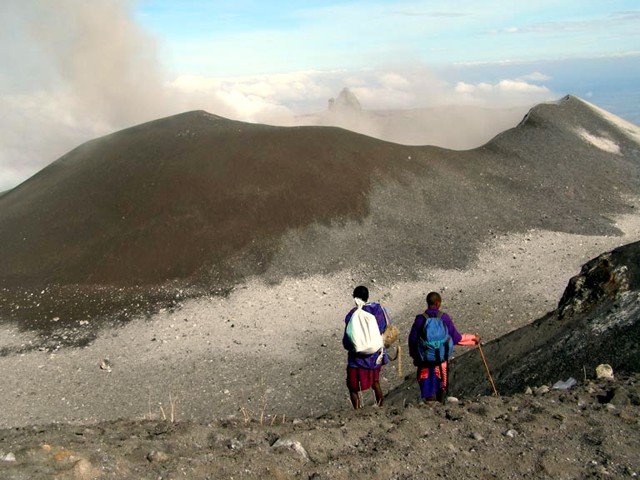 |
Figure 102. The ash-and-cinder cone that dominated the N crater of Ol Doinyo Lengai. Taken 7 December 2007 from the summit looking N. Courtesy of Joerg Keller. |
The cone was formed by and covered by ash, black-to-brown lapilli, cinders, angular blocks, and cored oval bombs. The magmatic lapilli contained macroscopic phenocrysts of nepheline, garnet, and wollastonite. With time, the black lapilli and bombs on the slopes of the cone and in the ring plain around it turned white by weathering of their components. Products of the active cone have covered almost all the old natrocarbonatite structures. Only the spiny remnant of the T49B hornito still stands out at the northern crater rim of the cone. The surface of a blocky flow was also still recognizable at the foot of the N wall.
Analyses of the magmatic material were in harmony with the recent observations of Roger Mitchell and Barry Dawson (reported in BGVN 32:11), who analyzed the mineralogy after the 24 September 2007 eruption, and their suggestion that at the onset of the explosive eruptive period on 4 September 2007 a silicate component became involved in the eruptive activity. Mitchell and Dawson concluded that "in lacking clinopyroxene, the mantling ash is not nephelinite or melilitite and is unlike any other magma type previously recorded from the volcano."
During the December fieldwork, Keller and Klaudius collected samples and examined cross-sections of the 4 September 2007 ash. Proximal (near-source) accumulations of tephra in the S crater occurred to a thickness of ~ 20 cm in the depression and on the upper slopes of the S flank, decreasing to a thickness of 1 cm at the E starting point of the new trail. This compared with a thickness of ~ 5 cm at the upper parking site of the old W trail and the abandoned Maasai home closest to the volcano, 4.2 km away (figure 103). Towards Engare Sero village, relics of the ashfall were still locally preserved and indicated an original thickness of ~ 1 cm, consistent with eyewitness reports of ashfall over the village during 4 September.
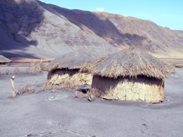 |
Figure 103. The abandoned settlement of the Lesele family, located in the major ash fallout area W of the volcano. Note the ash on the roofs of the huts. Courtesy of J. Keller and J. Klaudius. |
Other observations. Jens Fissenebert's visit on 25 December 2007 to the summit by helicopter again confirmed that the ash cone had grown. He estimated that it covered nearly the northern two-thirds of the crater floor. The N and W parts of the crater rim were indistinct, having been mostly covered by the growing flank of the new cone. Newly erupted ash and lapilli had filled in the flank area below the former crater rim and down through the "Pearly Gates" through which the former W climbing route passed.
Several eruptions were noted by Paul Johns when landing by helicopter on 6 January 2008. During early 2008, there were also occasional thermal anomalies measured by MODIS (table 17).
Table 17. MODIS/MODVOLC thermal anomalies measured at Ol Doinyo Lengai during January through early April 2008. Anomalies measured during 2007 were reported in BGVN 32:11. Courtesy of the Hawai'i Institute of Geophysics and Planetology (HIGP) Thermal Alerts System.
| Date | Time (UTC) | Number of pixels | Satellite |
| 08 Jan 2008 | 2030 | 2 | Terra |
| 17 Jan 2008 | 2025 | 2 | Terra |
| 17 Feb 2008 | 2240 | 3 | Aqua |
| 22 Feb 2008 | 2300 | 1 | Aqua |
| 28 Feb 2008 | 1135 | 1 | Aqua |
| 29 Feb 2008 | 2305 | 1 | Aqua |
| 07 Mar 2008 | 2310 | 1 | Aqua |
| 10 Mar 2008 | 2045 | 4 | Terra |
| 03 Apr 2008 | 1955 | 1 | Terra |
Vegard Laukhammer climbed the volcano with several others on 14 January 2008. Laukhammer reported arriving at the summit at 0652 (local time). "The visibility was so poor and there was so much smoke that we decided to try to climb down again after 10 minutes. . . . About 10 minutes later (0715), when we had been able to climb about 50 meters down from the summit, a thundering, ear-breaking sound came from the volcano. A large shower of rocks (many the size of a football) were thrown out from the volcano directly towards us 4 on the top" (translation from Norwegian by Sven Dahlgren, found on Belton's website). The climbers managed to descend without serious injury.
Tom Pfeiffer and a VolcanoDiscovery group stayed near and on Ol Doinyo Lengai during 17-21 January 2008. During this period episodic ash eruptions lasted several hours. These phases alternated with quiet intervals when there was only a weak plume of very fine gray ash and gas. After sunset on 17 January, strong ash eruptions started with plumes reaching about 500-1,000 m high, accompanied by strong lightning. After around 2130, Randle Robertson observed a fountain that appeared as a bright red-orange "blow-torch" rising from the summit crater to an estimated height of 500 m above the crater. The light was steady in appearance and lasted for at least 5 minutes. When the fountain died, a dark ash cloud emerged from the crater, which did not reach a great height. The volcano was more or less quiet during most of 18 January (figure 104).
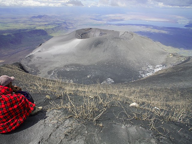 |
Figure 104. View looking N from the summit of Ol Doinyo Lengai, taken 18 January 2008. The large cone in the crater was quiet at this time. Courtesy of Volcano Discovery. |
At around 1600 on 19 January, weak explosions set in, increasing in intensity until the ash plumes reached about 500 m above the crater at around 1730 (figure 105). Blocks were ejected 300-400 m above the crater, and all explosions were near-vertical jets from two vents in the crater's W and central portions. Activity decreased after sunset. No incandescence was observed during the night. Activity intensified during the night, with loud-explosion sounds, and the hissing sound of gas-and-ash jets. During their descent on 20 January, ash eruptions continued until early afternoon.
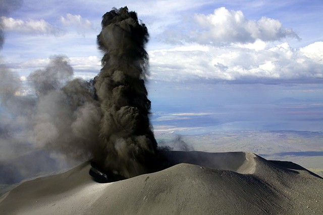 |
Figure 105. View looking N over the active crater from the summit of Ol Doinyo Lengai, taken 18 January 2008, showing the onset of ash eruption. Courtesy of Volcano Discovery. |
Michael Dalton-Smith observed a fairly large eruption at 1200 on 3 February 2008 from the Gol mountains just E of Sanjan gorge. He saw a cloud that rose about ~1 km above the summit. Activity was present all day, ceasing around 1600, followed by renewed activity with ash rising 0.3-0.5 km above the crater.
At about 0600 on 4 February there was a larger eruption with the ash rising about 1.4 km. It was a fairly dense cloud that flattened out at the top. The camp manger of Asilia (where Dalton-Smith was staying) also said that there had been several large explosive eruptions three days before (on 1 February). Two explosions were heard, one in the morning and one in the evening.
On 6 February, Dalton-Smith opted to not climb because of strong eruptions. When he drove past the volcano he reported that "it was having some of the biggest eruptions in a long time" with continuous activity from sunrise to about 1400.
During 3-5 March 2008, Tony Drummond-Murray and his wife observed very strong eruptions (figure 106). Figure 107 shows pyroclastic flows from what appeared to be a collapsing ash column. The valley between Lengai and the escarpment itself was covered with a highly visible layer of light ash after the eruption on 4 March. On 5 March the plume appeared even larger than the one seen on 4 March.
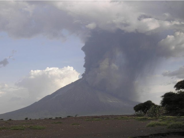 |
Figure 106. Large eruption of Ol Doinyo Lengai taken around 4 March 2008 from the Lake Natron area. Courtesy of Tony Drummond-Murray. |
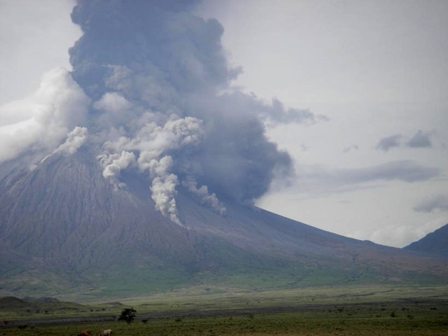 |
Figure 107. During an energetic eruption, small pyroclastic or debris flows propagated down the flanks of Ol Doinyo Lengai. This photo was taken around 4 March 2008 from the Lake Natron area. Courtesy of Tony Drummond-Murray. |
At 1010 on 5 March 2008, pilot Benoît Wilhelmi observed a plume rising to ~15 km altitude. On 12 March, he also saw a strong ash eruption; weaker activity was also seen that day (figure 108). That photo indicates that the powerful eruptions of 3-5 March did not significantly alter the ash cone or crater rim. Large amounts of ash and cinders had piled up against the northward facing ridge below the summit. The S crater was covered in ash and cinder layers so deep that previously prominent erosion gullies were becoming indistinct. It appeared that all vegetation had either died or been buried.
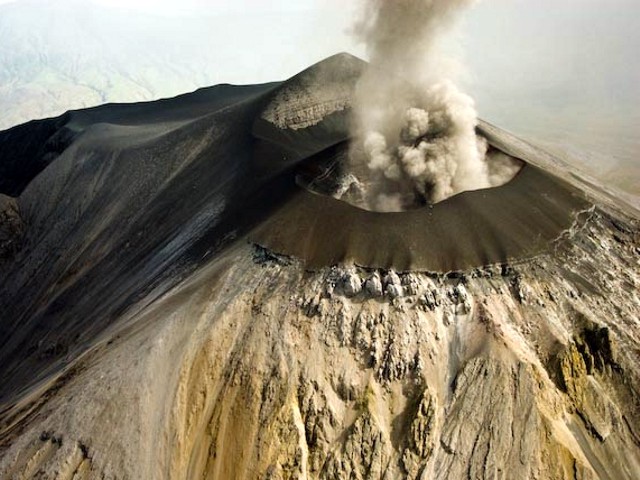 |
Figure 108. Ash eruption from Ol Doinyo Lengai seen 12 March 2008 from the NNE. This image shows that the E, N, and W flanks of the ash cone had buried the original crater rim. Oversteepening of the cone flank in places resulted in small landslides which can be seen just below the cone as dark material covering the lighter areas of older weathered carbonatite. The peak beyond the ash plume is the summit. Photo courtesy Benoît Wilhelmi. |
Wilhelmi photographed the summit cone on 18 March at 1530 (figure 109). On 22 March, Wilhelmi photographed directly into the crater (figure 110). At that time there had been no reports of activity for three days, but the smell of hydrogen sulfide returned after being gone for days.
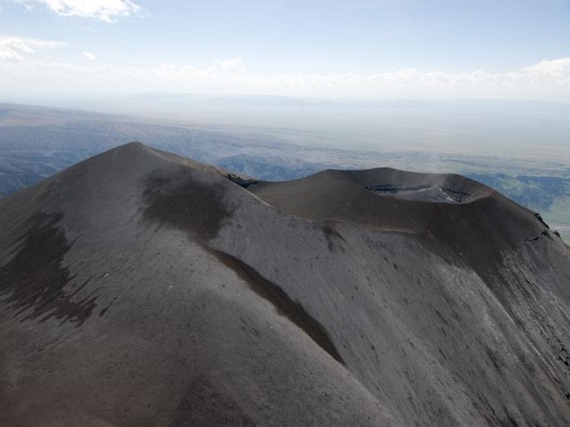 |
Figure 109. Aerial photo highlighting the summit profile of Ol Doinyo Lengai, as seen looking W at ~1530 (local time) on 18 March by Benoît Wilhelmi (pilot). Courtesy of Frederick Belton. |
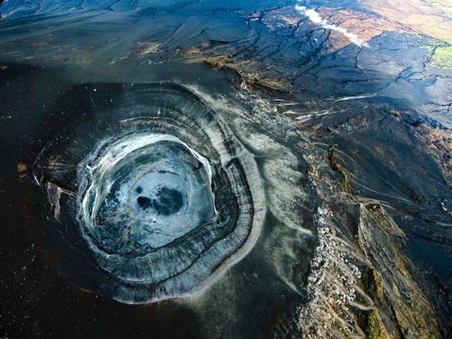 |
Figure 110. Aerial photo at Ol Doinyo Lengai looking sub-vertically, down into the new cone's crater. Taken at about 0930 (local time) on 22 March by Benoît Wilhelmi (pilot). Courtesy of Frederick Belton. |
Table 18 lists a number of volcanic ash advisories (VAAs) issued in March 2008 by the Toulouse Volcanic Ash Advisory Center (VAAC).
Table 18. March 2008 Volcanic Ash Advisories (VAAs) relating to Ol Doinyo Lengai issued by Toulouse Volcanic Ash Advisory Center (VAAC).
| Date | Time (UTC) | Information Source | Observed Details |
| 04 Mar 2008 | 0900 | Satellite | Eruption occurred at 0630 (UTC), cloud rising to 12.2 km may contain some ash; stopped by 0900. |
| 05 Mar 2008 | 0854 | Meterological watch office (MWO) Dar-Es-Salaam | Eruption of very short duration; "simple puff", ash cloud to 10.7 km altitude. |
| 06 Mar 2008 | 1730 | MWO Dar-Es-Salaam | Eruption occurred at 0830 (UTC); cloud top at 9.1 km altitude, ash not identified from satellite. |
| 09 Mar 2008 | 0845 | MartinAir | Current eruption; ash plume to 8.8 km altitude, ash not identified from satellite. |
| 10 Mar 2008 | 0711 | Satellite | Cloud to 7.3 km altitude. |
| 11 Mar 2008 | 1800 | Infrared satellite | Possible brief eruption at about 1700 (UTC); cloud up to 12.2 km altitude, moving S. |
| 13 Mar 2008 | 1800 | KLM pilot, MartinAir | Volcanism with ash cloud rising to 12.2 km altitude. |
| 16 Mar 2008 | 0450 | Satellite | Short eruption at ~0330 (UTC); plume reached 13.7 km altitude. |
| 16 Mar 2008 | 2148 | Satellite | Ash cloud to 12.2 km altitude. |
Thomas Holden reported that as of 29 March 2008 there had been no activity at Lengai for 10 days. Chris Daborn (Tropical Veterinary Services Ltd.) reported on 2 April 2008 the following: "Lengai has of late quieted down significantly-first in changing ash colour from a 'salty' white to a more inert black and now with much smaller eruptions that barely extend above the mountain. We have heavy rains on at present which makes movement in the area difficult-but are also washing ash residue away." Jurgis Klaudius reported that he checked MODIS data and found a thermal anomaly in the N crater on 3 April 2008, indicating on-going eruptions then (table 17).
Warnings of hazards. Celia Nyamweru posted the following warning on her web site: "A team of Tanzanian, US, and French scientists visited the region around the volcano in January 2008, and interviewed local porters who routinely climb Ol Doinyo Lengai with tourists. Our observations and photos indicate continuing eruptive activity, and a growing threat to the region, as outlined below.
"Almost daily eruptions from the central caldera have filled the crater, and produced a steep lapilli-ash cone around the crater rim. A film clip of the crater made by a Medecins Sans Frontieres pilot confirms that the loose lapilli is near collapse. These conditions mean that there are very high risks of one or more of the following: 1) a debris flow or lahar (mix of hot ash, water/mud) down the existing channels around the volcano; 2) burns from hot lapilli and ash; and 3) catastrophic collapse of the steep lapilli cones around the crater. The risks increase with increasing rainfall during the March-May rains.
"We also urge extreme caution to anyone driving in the river channels on the eastern and northern slopes of Lengai between Engaruka and Ngare Sero. There are scars of immense debris flows on the flanks of Kerimasi, and smaller scars on Ol Doinyo Lengai. These scars attest to catastrophic flows in the past, some of which carried rock fragments up to 50 cm in diameter for distances extending up to 10 km from Ol Doinyo Lengai. Even smaller debris flows could do great damage to vehicles and people moving along the eastern and northern slopes of the volcano."
Reference. Kervyn, M., Ernst, G.G.J., Klaudius, J., Keller, J., Kervyn, F., Mattsson, H.B., Belton, F., Mbede, E., and Jacobs, P., 2008, Voluminous lava flows at Ol Doinyo Lengai in 2006: chronology of events and insights into the shallow magmatic system: Bulletin of Volcanology, DOI 10.1007/s00445-007-0190-x.
Geological Summary. The symmetrical Ol Doinyo Lengai is the only volcano known to have erupted carbonatite tephras and lavas in historical time. The prominent stratovolcano, known to the Maasai as "The Mountain of God," rises abruptly above the broad plain south of Lake Natron in the Gregory Rift Valley. The cone-building stage ended about 15,000 years ago and was followed by periodic ejection of natrocarbonatitic and nephelinite tephra during the Holocene. Historical eruptions have consisted of smaller tephra ejections and emission of numerous natrocarbonatitic lava flows on the floor of the summit crater and occasionally down the upper flanks. The depth and morphology of the northern crater have changed dramatically during the course of historical eruptions, ranging from steep crater walls about 200 m deep in the mid-20th century to shallow platforms mostly filling the crater. Long-term lava effusion in the summit crater beginning in 1983 had by the turn of the century mostly filled the northern crater; by late 1998 lava had begun overflowing the crater rim.
Information Contacts: Joerg Keller and Jurgis Klaudius, Mineralogisch-geochemisches Institut, Albertstr. 23B D-79104 Freiburg, Germany; Jens Fissenebert, Molvaro-Lake Natron Tented Camp and Campsite; Vegard Laukhammer, Norway; Frederick Belton, Developmental Studies Department, PO Box 16, Middle Tennessee State University, Murfreesboro, TN 37132, USA (URL: http://oldoinyolengai.pbworks.com/); J. Barry Dawson, Grant Institute of Earth Science, University of Edinburgh, King's Building, Edinburgh EH9 3JW, U.K.; Roger Mitchell, Lakehead University, 955 Oliver Road, Thunder Bay, Ontario, Canada P7B 5EI; Hawai'i Institute of Geophysics and Planetology (HIGP) Thermal Alerts System, School of Ocean and Earth Science and Technology (SOEST), Univ. of Hawai'i, 2525 Correa Road, Honolulu, HI 96822, USA (URL: http://modis.higp.hawaii.edu/); Celia Nyamweru, Department of Anthropology, St. Lawrence University, Canton, NY 13617 USA (URL: http://blogs.stlawu.edu/lengai/); Toulouse Volcanic Ash Advisory Center (VAAC) (URL: http://www.meteo.fr/vaac/); Michael Dalton-Smith (URL: http://digitalcrossing.ca/); Lake Natron Camp (URL: http://www.ngare-sero-lodge.com/); Chris Weber, Volcano Expeditions International (VEI) (URL: http://www.v-e-i.de/).