Report on Rabaul (Papua New Guinea) — March 2008

Bulletin of the Global Volcanism Network, vol. 33, no. 3 (March 2008)
Managing Editor: Richard Wunderman.
Rabaul (Papua New Guinea) Main vent plugged; seismicity, deformation, explosions, and H2S all high
Please cite this report as:
Global Volcanism Program, 2008. Report on Rabaul (Papua New Guinea) (Wunderman, R., ed.). Bulletin of the Global Volcanism Network, 33:3. Smithsonian Institution. https://doi.org/10.5479/si.GVP.BGVN200803-252140
Rabaul
Papua New Guinea
4.2459°S, 152.1937°E; summit elev. 688 m
All times are local (unless otherwise noted)
This report describes ash plumes (figure 48) and explosions (table 9) located at Tavurvur, a cone located on the NE flank of Rabaul caldera. Tavurvur's summit sits at ~ 240 m elevation. The largest nearby settlement is Rabaul Town. Throughout the course of this report, audible sounds such as roaring, glowing of the cone, incandescent events, and hydrogen-sulfide (H2S) odor were frequently reported. RVO interpreted high-frequency earthquakes as rocks breaking or explosion events, and low-frequency earthquakes driven by fluids, steam or gas (rarely liquid magma), their motions imparting a slower shaking or rocking to the ground.
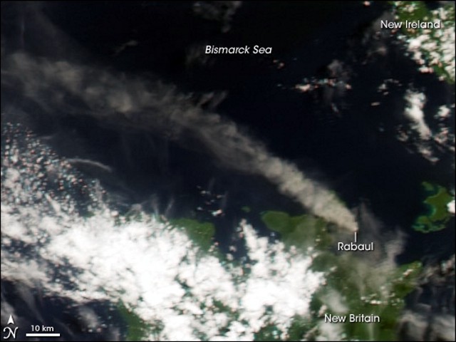 |
Figure 48. MODIS satellite image of a Rabaul ash plume on 18 March 2008.The plume can be seen over 150 km. Courtesy of NASA Earth Observatory. |
Table 9. Summary of events at Rabaul's Tavurvur cone during August 2007 to April 2008. Not all events are reported here. Further details of some of the events can be found in the text. Some data such as plume height or direction of plume were not measured. Areas effected by ashfall can generally be found in the text. Courtesy of the Darwin VAAC.
| Date | Plume height (km) | Direction | Notes and Comments |
| 01-07 Aug 2007 | 0.9-1.7 | N, NW, W | Thick, dark gray. Occasional emission of white vapors. Ashfall. |
| 14-20 Aug 2007 | -- | -- | White vapors. Accompanied by blue vapor plumes. |
| 22-28 Aug 2007 | 3 | -- | -- |
| 03 Sep 2007 | -- | NW | Gray ash. Fine ashfall. |
| 04 Sep 2007 | 2 | WNW | White vapor. |
| 20-24 Sep 2007 | 1.2 | W, NW | White vapor. Ashfall. |
| 25 Sep 2007 | 1.7 | W | -- |
| 02 Oct 2007 | 2.4 | -- | -- |
| 03 Oct 2007 | 1.7-2.7 | NW | Ashfall. |
| 04 Oct 2007 | -- | W | Ashfall. |
| 08-23 Oct 2007 | 1.7-2.7 | NNE, S | Thick white, gray ash clouds. Occasional explosions, ashfall on large area. |
| 29-30 Oct 2007 | 2.7-3.7 | -- | Ashfall. |
| 10 Dec 2007 | 2 | SSE, E, NW, W | Thick dark ash clouds. Ashfall. |
| 11 Jan 2008 | 1.2-1.5 | SE | Ash plume. |
| 11-15 Jan 2008 | 0.9-1.2 | SE, E, NE, N, W | Ash vapor plume. Ashfall. |
| 18-20 Jan 2008 | 1.7 | NE | -- |
| 28 Jan 2008 | 1.7 | W | -- |
| 29-30 Jan 2008 | 1.7 | SW, W, E | Ash and gas plumes. |
| 01-03 Feb 2008 | 1.2 | SSE | Weak ash emissions. |
| Mid Feb 2008 | 1.2-1.7 | NW, W, SW, S, SE, E | Thick gray ash clouds. Long duration of ashfall. |
| 26 Feb 2008 | 3.7 | SE, E | Thick billowing ash plumes. Explosion caused ashfall. |
| 27 Feb-04 Mar 2008 | 0.9-2.2 | W | Ash and steam plumes. Ashfall. |
| 08-10 Mar 2008 | 1.2-1.7 | NW, W, SW, S, SE | Ash plumes. Ashfall. |
| 13 Mar 2008 | 2.5 | NE | Ashfall. |
| 16 Mar 2008 | 2 | S, W | Gray ash. Ashfall. |
| 17 Mar 2008 | 2.5 | WNW | High ashfall, rapid gas escape. |
| 18 Mar 2008 | 2 | WNW | -- |
| 19 Mar 2008 | 2 | NW, N | -- |
| 20 Mar 2008 | 2 | NW, SSE | Ashfall. |
| 21 Mar 2008 | -- | S | Fine ashfall. |
| 22 Mar 2008 | 1 | SW, W, NW | Ashfall. |
| 23 Mar 2008 | 2.5 | N, SE | Ashfall. |
| 26 Mar 2008 | 1.5 | SE | Ashfall, disruption of aviation. |
| 27 Mar 2008 | 2 | S | Thick gray. |
| 28 Mar 2008 | 0.5-1.0 | W, SW | Gray. |
| 30 Mar 2008 | 1-2 | N, NW | Thick white vapor gray ash clouds. |
| 01 Apr 2008 | 0.5 | -- | Fluctuating between water vapor and dense gray ash. Occasional explosions. |
| 03 Apr 2008 | 1 | SE | Discrete puffs gray ash. Rarer explosions. |
| 07-09 Apr 2008 | 1 | E | Gray ash clouds. Ashfall. |
| 13 Apr 2008 | 1-1.5 | W, NW | Ashfall. |
| 28 Apr 2008 | 1-1.5 | N | Gray. |
Low eruptive activity such as reported in this issue have been periodically occurring since the powerful explosion in 1994. Our last report (BGVN 32:06) reported the six explosions that occurred in June and July (2007) at Tavurvur cone that produced shockwaves that rattled windows of houses in Rabaul Town and surrounding areas. The explosions also showered the flanks with lava fragments and conveyed ashfall and sulfurous odors to the NW.
RVO stated that there was no indication of any build up that might lead to significant eruptive activity like in October 2006. Ground deformation remains to be in a deflated but stable state. Seismic activity remains at a moderate to high level dominated by low-frequency earthquakes.
Throughout the entire period covered by these observations and reports, authorities have been regularly advising the public not to venture close to the volcano due to the possibility of rocks being expelled during the occasional eruptions.
Late July 2007. Rabaul Volcanic Observatory (RVO) described this time as marked by minor eruptions. The activity consisted of emission of thin to thick, white, and bluish vapor, which rose to an altitude of ~ 0.9 km and drifted NNW. Roaring noises were occasionally heard and incandescence was intermittently visible at the crater rim.
Red glow was visible at night, associated with a small lava dome centrally located within Tavurvur's wide vent. A weak smell of sulphur was evident on the downwind side of the vapor plume on 25 July. Occasional low roaring noise continued to be heard and a weak to bright red glow was visible above the crater rim on 28 and 29 July. On 30 July, a white plume with little ash content rose to an altitude of 2.7 km and drifted SW.
Seismicity was low but it and deformation were consistent with a dynamic and restless caldera. The real-time GPS at the caldera's center of the showed that centimeter-scale movements often occurred over a few hours. Small inflation events sometimes preceded activity by 6-12 hours. Only 17 low-frequency earthquakes were recorded between 22 and 27 July. One high-frequency earthquake was recorded on 26 July which originated NE of the caldera. Ground deformation continued to show a slow inflation trend with movement N.
August 2007. August activity was characterized by Tarvurvur emitting almost continuous ash and vapor plumes. During 1-7 August 2007, ashfall was reported at Rabaul Town (~ 6.5 km NW of the vent) and surrounding areas. Seismicity was generally moderate during the earlier part of August but increased to higher levels between 22-29 August. Activity was usually low frequency earthquakes, with occasional high-frequence earthquakes between 25-29 August. Five weak explosions were recorded on 27 August.
Ground deformation was stable until the middle of August when minor uplifts were noted. On 22 August, a marked uplift began and then subsided with the resumption of ash emissions. The subsidence continued until 28 August when a minor uplift began but subsided on 30 August.
A total of 1,087 low frequency earthquakes were recorded during 28-31 August. Three weak explosions were recorded on 30 August, but no high-frequency earthquakes were recorded. Ash emission persisted before declining significantly on the night of 30 August. A total of 150 low-frequency earthquakes were recorded on 31 August. After a momentary eruptive interlude took place at the end of August, blending into early September
September 2007. On 2 September, fine ashfall continued on Rabaul Town. Seismicity continued at a moderate level, dominated by bands of irregular tremor and discrete low-frequency earthquakes. A total of 886 low-frequency earthquakes were recorded during 1-5 September; no high-frequency events were recorded. During 6-10 September there was little or no ash emitted. Emissions consisted of billowing white fume when atmospheric conditions were humid or cool. During hot dry periods, observers saw clear air above the cone, with a white plume appearing several hundred meters higher. On 8 September, odors of H2S became noticeable downwind; this coincided with a blue tinge to the plume. Ground deformation measurements indicated an uplift. Emissions began again on 20 September, with ashfall in Rabaul Town and areas downwind, including Namanula Hill (3 km W). On 27 September, a large explosion was noted. During 30 September-2 October, incandescent fragments were ejected from the summit and rolled down the flanks.
October 2007. On 3 October ashfall was reported from areas downwind, including Rabaul Town. On 4 October ash plumes resulted in ashfall in Matupit Island (3.3 km SE), Malaguna. Incandescent fragments were ejected from the summit. On 5 October, vapor plumes with minor ash content were noted. During 8-23 October, occasional explosions produced ash plumes. Ashfall was reported at Namanula Hill and surrounding areas. Continuous weak glow was visible at night and incandescence at the summit was observed. The glow was bright on the night of 17 October. On 29-30 October ashfall was reported in Rabaul Town. Seismicity continued at moderate to moderately high level between the 17th and 20th. One high-frequency event was recorded on 21 October from NE of Rabaul.
November 2007. In late November, after five weeks of low-level activity, Tavurvur began to emit ash from a new vent on the NE crater rim. The new vent was formed as a result of the lava dome blocking the vent on the crater floor. The activity progressed and on 8-9 December emissions were thick white gray ash. The new dome has been the source of the continuous red glow visible at night.
December 2007. There was a slight increase in seismicity during December, but it was still low. The average daily number of low-frequency earthquakes was 20 during 1-3 December, before increasing to 55 during 4- 6 December, and 85 during 7- 8 December. The activity was accompanied by low-level sub-continuous signals. Two high-frequency earthquakes were recorded on 3 December which originated NE of the caldera. Ashfall continued downwind, including Rabaul Town. During 13-18 December, white plumes were observed and a strong smell of H2S gas was reported.
January 2008. January 2008 continued the December activity. White ash and vapor plumes continued from the Tavurvur cone. The eruptive activity came from vents based on the inner eastern wall. One vigorous coneless fumarole on the upper outer eastern flank occasionally erupted ash. Unfortunately, NW winds carried ash towards the Provincial Airport (5.3 km NW) on a few occasions, causing closures.
During 11-12 January slight ashfall was reported about 20 km SE of Tokua. On 17 January ashfall at Tokua, prompted Air Niugini to cancel some flights. During 18-20 January, the ash plumes were released at 10-20 minute intervals. Slight ashfall was reported in areas on the E coast. Incandescence from the center of the crater was visible at night throughout most of January.
Deformation-monitoring instruments indicated that uplift started on 23 January and peaked during 25-26 January with 2 cm of inflation. On 26 January, ashfall was quite heavy but died down on the morning of 27 January. Seismicity remained moderately high, with small sub-continuous low-frequency signals dominating. In the preceeding 24 hrs there were 400 low-frequency events and 3 explosion type signals, most of them were not associated with the seen emissions. There were no high-frequency or hybrid events. There were small explosion type signals, even when ash was not emitted. Deformation monitoring showed a slight uplift superimposed on the gradual 6 month long subsidence. On 29 January two small, instrumentally recorded, high-frequency events occured within the caldera, one between Tavurvur and Rabalanakia and the other just off the E coast of Vulcan (the first here since the '94 eruption). Deformation monitoring showed that the center of the caldera underwent a rapid centimetre scale uplift and matching deflation on 31 January.
February 2008. There was little variance in the activity at Tarvurur which was essentially a continuation of the January activity. Because of light winds, the plumes reached 1 km above Tavurvur. Drift was predominantly E. During 1-3 February ashfall was reported in Kokopo (20 km SE). On 4 February, a strong smell of H2S gas was reported from Rabaul Town (3-5 km NW). Incandescence from the center of the crater was visible almost every night.
Low-frequency seismicity was moderately high and increased slightly, with occasional low-frequency signals dominating. Some hybrid events were also recorded. Seismic activity did not always appear to be related to the observed events. Deformation monitoring showed that the center of the caldera remaining reasonable stable during the early part of the month, although the trend was towards inflation. On 5 February, deformation monitoring showed some small, but significant movements with horizontal strain greater than vertical. A slight deflation was noted.
Toward the middle of February, ashfall was reported everyday in areas downwind, including Matupit, Kokopo, and Rabaul Town, and surrounding areas. Incandescence at the summit was noted and incandescent material was propelled from a vent on the inner E wall of the crater. Seismic activity remained at moderate levels; but again, the activity did not always appear to be related to observed events. Deflation appeared to continue but only slightly. Occasional periods of high level seismic activity were dominated by low-frequency volcanic earthquakes. A total of over 1,570 events were recorded during 7-8 February. Ground deformation showed no significant movement although the trend after 9 February was towards inflation.
From 13-19 February, ashfall was reported in Barovon, Lalakua, Raluana, Kokopo, and surrounding villages. During 19-20 February, incandescence at the summit was accompanied by projections of lava fragments. Ground deformation as indicated by both the GPS and water-tube tiltmeter continued to indicate a trend towards inflation. On 25 February an explosion showered the flanks with lava fragments. On 26 February a large explosion occurred. The flanks were again showered with lava fragments. Ashfall was reported in Kokopo and surrounding areas.
March 2008. Tavurvur's activity during March was a continuation of the preceeding months. During 27 February-4 March ashfall was reported in areas downwind, including Matupit. A smell of H2S gas was again reported in Rabaul Town. During 3-7 March, incandescence at the summit. A slight smell of H2S was reported in areas to the S on 5 March. During 8-11 March, ash fall was reported in areas downwind, including Kokopo town (SE), and Rabaul Town (NW) on 11 and 13 March. Seismic activity often remained at a high level during March, but, the instrument's batteries died during 10-11 March. A total of over 980 events were recorded on 9 March. No high-frequency earthquakes were recorded. Deformation continued to indicate an inflationary trend after 8 March. On 13 March fine ash fell upon Rabaul Town. Ground deformation began towards an inflation trend after previous indications towards deflation. Unlike most plume eruptions, on 13 March sounds were not recorded. On 17 March moderate to heavy ash fall rained on Matupit island and surrounding areas.
At 1105 on 20 March a large explosion occurred showering the flanks with lava fragments. The shockwave rattled windows in Rabaul Town. At 1730 on 22 March 2008 an explosion occurred showering the flanks with lava fragments. During 22-23 March areas downwind had ashfall.
On 25 March 2008 ash clouds formed a broad fan from S at Barovon/Ialakua to Kokopo. The cloud drifted SE towards Tokua later that morning. During the morning on 26 March 2008 ash plumes caused Air Niugini flights into Tokua to be affected.
During 27 March into July 2007 overall deflation was 5 cm of subsidence, step-wise with small superimposed up lifts. RVO suggested that low-pressure intrusions were periodically rising in an open conduit causing the uplift before intersecting with the surface. The overall deflation implied that the deeper source was being depleted. The deformation measurements were made at Matupit. Constant expansion and degassing of magma in the recent weeks had apparently kept the conduit open. Pressure and debris have started to block the mouth of the vent by compaction and partial welding of molten material. This would lead to pressure build-up causing periodic explosions, in a plausible waning explosive phase.
April-May 2008. On 2 April ground deformation was stable with small and continued rapid fluctuations due to the repeating sealing and rupturing of the shallow conduit. Seismicity generally became moderate, but still generally dominated by low-frequency earthquakes. Activity was no longer preceded by notable explosions. The vent would be clear for a period of time. On 7 April a high-frequency event occurred NE of the caldera. On 9-10 April 9 mm of uplift occurred. On 11 April moderate ashfall was noted in Rabaul Town. Fine ashfall occurred in Matupit island. Seismic activity returned to a high level dominated by low-frequency earthquakes. On 11 April a total of 1,000 earthquakes were recorded. At 1100 on 22 April a modest explosion occurred. On 23 April 1-2 mm of non compacted flocculated pale ash was deposited in a sector from Malaguna E to S of Matupit. The cone was obscured to vision. On 28 April ground deformation was in a deflated but stable state. Ashfalls on 2 May left 3-4 cm in eastern Rabaul and 1-2 cm in western Rabaul.
Geological Summary. The low-lying Rabaul caldera on the tip of the Gazelle Peninsula at the NE end of New Britain forms a broad sheltered harbor utilized by what was the island's largest city prior to a major eruption in 1994. The outer flanks of the asymmetrical shield volcano are formed by thick pyroclastic-flow deposits. The 8 x 14 km caldera is widely breached on the east, where its floor is flooded by Blanche Bay and was formed about 1,400 years ago. An earlier caldera-forming eruption about 7,100 years ago is thought to have originated from Tavui caldera, offshore to the north. Three small stratovolcanoes lie outside the N and NE caldera rims. Post-caldera eruptions built basaltic-to-dacitic pyroclastic cones on the caldera floor near the NE and W caldera walls. Several of these, including Vulcan cone, which was formed during a large eruption in 1878, have produced major explosive activity during historical time. A powerful explosive eruption in 1994 occurred simultaneously from Vulcan and Tavurvur volcanoes and forced the temporary abandonment of Rabaul city.
Information Contacts: Steve Saunders and Herman Patia, Rabaul Volcanological Observatory (RVO), Department of Mining, Private Mail Bag, Port Moresby Post Office, National Capitol District, Papua New Guinea (URL: http://www.pngndc.gov.pg/); NASA Earth Observatory (URL: http://earthobservatory.nasa.gov/).