Report on Chikurachki (Russia) — March 2008
Bulletin of the Global Volcanism Network, vol. 33, no. 3 (March 2008)
Managing Editor: Richard Wunderman.
Chikurachki (Russia) New eruption with significant ash plumes began in mid-August 2007
Please cite this report as:
Global Volcanism Program, 2008. Report on Chikurachki (Russia) (Wunderman, R., ed.). Bulletin of the Global Volcanism Network, 33:3. Smithsonian Institution. https://doi.org/10.5479/si.GVP.BGVN200803-290360
Chikurachki
Russia
50.324°N, 155.461°E; summit elev. 1781 m
All times are local (unless otherwise noted)
Olga Girina of the Kamchatka Volcanic Eruptions Response Team (KVERT) reported no eruptive activity at Chikurachki volcano [activity that began 4 March 2007 (BGVN 32:05)] after about 18 April 2007. The following report was based primarily on information found on the KVERT website. Chikurachki is not monitored with seismic instruments, but KVERT has satellite monitoring and receives occasional reports of visual observations (figure 5).
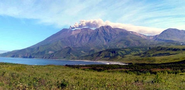 |
Figure 5. Ash plume extending to the ESE from Chikurachki on 8 September 2007. Photo by L. Kotenko, supported by JSPS (Japan Society for the Promotion of Science); courtesy of KVERT Current Activity of Chikurachki website. |
According to observations, no eruptive activity was noted on 12 and 14 August. However, visual information from Podgorny (20 km SSE) indicated that an eruption began on 18 August 2007 at 2200 UTC. Ashfall was noted in Podgorny at that time and on 19-20 August, and satellite data showed an ash plume extending about 120 km SE (figure 6). An ash plume extending about 100 km SE at an altitude of 5 km was observed by pilots on 20 August 20 at 0140 UTC. An ash plume extending about 160 km to the NNE at an altitude of 3 km and ashfall on Alaid volcano were noted by volcanologists on 21 August. Table 2 lists observations, when available, of the ash plume during this eruption.
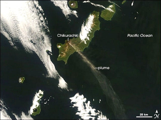 |
Figure 6. Plume from Chikurachki taken 19 August 2007 by the Moderate Resolution Imaging Spectroradiometer (MODIS) flying on NASA's Aqua satellite. Besides Chikurachki, whose plume blows SE over the ocean, the image captures the summits of neighboring volcanos Atlasova Island and Fuss Peak above the cloud cover. Courtesy of NASA Earth Observatory. |
Table 2. Ash plume observations for the eruption of Chikurachki beginning 18 August 2007. Clouds obscured the volcano on most days not noted. Courtesy of KVERT.
| Date | Plume altitude | Plume distance/direction | Type of observation |
| 18 Aug 2007 | -- | -- | Visual |
| 19-20 Aug 2007 | 2.4 km | 120 km SE | Satellite |
| 20 Aug 2007 | 5 km | 100 km SE | Visual |
| 21 Aug 2007 | 4-5 km | 160 km NE | Visual, Satellite |
| 21-26 Aug 2007 | 1 km | -- | Visual |
| 28-30 Aug 2007 | ~3 km | 150-300 km NE | Satellite |
| 31 Aug, 01 Sep 2007 | ~3 km | 30-160 km NE | Satellite |
| 03 Sep 2007 | -- | S, SE | Satellite |
| ~06 Sep 2007 | 3.2 km | -- | Visual |
| 07 Sep 2007 | -- | more than 80 km SE | Satellite |
| 08 and 11 Sep 2007 | 2.3 km | ESE | Visual, Satellite (figure 5) |
| 18-19 Sep 2007 | -- | more than 110 km | Satellite (figure 6) |
| 19-20 Sep 2007 | -- | more than 250 km E | Visual |
| 21 Sep 2007 | -- | more than 75 km ESE | Satellite |
| 04 Oct 2007 | -- | more than 100 m ESE | Satellite |
| 07 and 10 Oct 2007 | -- | more than 50 km NE | Satellite |
| 17-18 Oct 2007 | -- | more than 180 km NE | Satellite |
| 20 Oct 2007 | -- | more than 50 km NW | Satellite |
The eruption continued through at least 25 October 2007, and perhaps through 8 November. Clouds obscured the volcano on many days, making estimates of the continuity of this eruption and its ending date difficult. KVERT has reported no later plumes observed over Chikurachki to mid-April 2008. No thermal anomalies were measured by the MODIS satellites during 2007 or 2008 to 20 April.
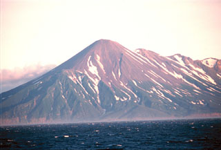
Geological Summary. Chikurachki, the highest volcano on Paramushir Island in the northern Kuriles, is a relatively small cone constructed on a high Pleistocene edifice. Oxidized basaltic-to-andesitic scoria deposits covering the upper part of the young cone give it a distinctive red color. Frequent basaltic Plinian eruptions have occurred during the Holocene. Lava flows have reached the sea and formed capes on the NW coast; several young lava flows are also present on the E flank beneath a scoria deposit. The Tatarinov group of six volcanic centers is located immediately to the south, and the Lomonosov cinder cone group, the source of an early Holocene lava flow that reached the saddle between it and Fuss Peak to the west, lies at the southern end of the N-S-trending Chikurachki-Tatarinov complex. In contrast to the frequently active Chikurachki, the Tatarinov centers are extensively modified by erosion and have a more complex structure. Tephrochronology gives evidence of an eruption around 1690 CE from Tatarinov, although its southern cone contains a sulfur-encrusted crater with fumaroles that were active along the margin of a crater lake until 1959.
Information Contacts: Olga Girina, Kamchatka Volcanic Eruptions Response Team (KVERT), a cooperative program of the Institute of Volcanic Geology and Geochemistry, Far East Division, Russian Academy of Sciences, Piip Ave. 9, Petropavlovsk-Kamchatsky, 683006, Russia, the Kamchatka Experimental and Methodical Seismological Department (KEMSD), GS RAS (Russia), and the Alaska Volcano Observatory (USA) (URL: http://www.kscnet.ru/ivs/kvert/updates.shtml); Alaska Volcano Observatory (AVO), a cooperative program of the U.S. Geological Survey, 4200 University Drive, Anchorage, AK 99508-4667, USA (URL: http://www.avo.alaska.edu/), the Geophysical Institute, University of Alaska, PO Box 757320, Fairbanks, AK 99775-7320, USA, and the Alaska Division of Geological and Geophysical Surveys, 794 University Ave., Suite 200, Fairbanks, AK 99709, USA; NASA Earth Observatory Natural Hazards (URL: http://earthobservatory.nasa.gov/NaturalHazards/); KVERT Current Activity of Chikurachki (URL: http://www.kscnet.ru/ivs/kvert/current/chkr/).