Report on Papandayan (Indonesia) — June 2008
Bulletin of the Global Volcanism Network, vol. 33, no. 6 (June 2008)
Managing Editor: Richard Wunderman.
Papandayan (Indonesia) Minor seismic activity and fumarolic plumes through 16 April 2008
Please cite this report as:
Global Volcanism Program, 2008. Report on Papandayan (Indonesia) (Wunderman, R., ed.). Bulletin of the Global Volcanism Network, 33:6. Smithsonian Institution. https://doi.org/10.5479/si.GVP.BGVN200806-263100
Papandayan
Indonesia
7.32°S, 107.73°E; summit elev. 2665 m
All times are local (unless otherwise noted)
Our last report on Papandayan (BGVN 29:08) described a modest surge in seismicity that began in July 2004, which rose for a short time but began to subside in mid-August 2004. We received no subsequent reports until June 2005. This report discusses non-eruptive restlessness from early June 2005 through the middle of April 2008, including wide fumarolic temperature variations, seismicity, and occasional minor steam plumes.
Beginning in early June 2005, the number of volcanic earthquakes increased in comparison to the previous months, and fumarole temperatures increased 3-9°C above normal levels. People were not permitted to visit Mas and Baru craters. On 16 June 2005, the Center of Volcanology and Geological Hazard Mitigation (CVGHM) in Indonesia raised the Alert Level at Papandayan from 1 to 2 (on a scale of 1-4) due to increased activity at the volcano. The Alert Level remained at 2 at least through 13 December 2005.
No subsequent reports were received until July 2007. On 15 July there was one volcanic earthquake; the next day 2-10 volcanic earthquakes were recorded. By 31 July, fumarole temperatures had increased 10°C above normal levels in Mas crater. On 1 August up to 53 volcanic earthquakes were recorded and a diffuse white plume rose to an altitude of 2.7 km. Residents and tourists were not permitted within a 1 km radius of the active craters.
On 2 August 2007, CVGHM raised the Alert Level from 1 to 2 (on a scale of 1-4) due to increased seismic activity at the volcano. Seismic events decreased in number after 2 August; earthquake tremors were not recorded after 14 November 2007, and on 7 January 2008, CVGHM lowered the Alert Level at Papandayan from 2 to 1 due to the decrease in activity during the previous four months. Data from deformation-monitoring instruments indicated deflation. White fumarolic plumes rose to an altitude of 2.9 km.
No subsequent reports were received until April 2008. According to the CVGHM, on 15 April the seismic network recorded one tremor signal. On 16 April, measurements of summit fumaroles revealed that the temperature had increased and water chemistry had changed since 7 April. White plumes continued to rise to an altitude of 2.7 km. CVGHM again increased the Alert Level to 2 and warned people not to venture within 1 km of the active crater.
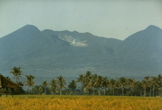
Geological Summary. Papandayan is a complex stratovolcano with four large summit craters, the youngest of which was breached to the NE by collapse during a brief eruption in 1772 and contains active fumarole fields. The broad 1.1-km-wide, flat-floored Alun-Alun crater truncates the summit of Papandayan, and Gunung Puntang to the north gives a twin-peaked appearance. Several episodes of collapse have created an irregular profile and produced debris avalanches that have impacted lowland areas. A sulfur-encrusted fumarole field occupies historically active Kawah Mas ("Golden Crater"). After its first historical eruption in 1772, in which collapse of the NE flank produced a catastrophic debris avalanche that destroyed 40 villages and killed nearly 3000 people, only small phreatic eruptions had occurred prior to an explosive eruption that began in November 2002.
Information Contacts: Center of Volcanology and Geological Hazard Mitigation (CVGHM), Jalan Diponegoro No. 57, Bandung 40122, Indonesia (URL: http://vsi.esdm.go.id/).