Report on Okmok (United States) — June 2008
Bulletin of the Global Volcanism Network, vol. 33, no. 6 (June 2008)
Managing Editor: Richard Wunderman.
Okmok (United States) Large explosive eruption started on 12 July, ash plumes initially rose to 15.2 km altitude
Please cite this report as:
Global Volcanism Program, 2008. Report on Okmok (United States) (Wunderman, R., ed.). Bulletin of the Global Volcanism Network, 33:6. Smithsonian Institution. https://doi.org/10.5479/si.GVP.BGVN200806-311290
Okmok
United States
53.43°N, 168.13°W; summit elev. 1073 m
All times are local (unless otherwise noted)
The Alaska Volcano Observatory (AVO) reported that on 12 July 2008 at 1143 a strong explosive eruption at Okmok began abruptly after about an hour of rapidly escalating earthquake activity. The Volcano Alert Level was raised to Warning and the Aviation Color Code was raised to Red from the previous Alert Level of Normal/Green. The last explosive eruption began on 13 February, 1997 (BGVN 22:01) from a cone on the south side of the caldera floor. Lava flowed across the caldera floor until 9 May. Ash plumes generally rose to altitudes of 1.5-4.9 km from 13 February to about 23 May, when thermal anomalies and plumes were no longer seen on satellite imagery. One ash plume rose to an altitude of 10.5 km on 11 March. In May 2001 a small seismic swarm (BGVN 26:08) was detected in the vicinity of the volcano. The earthquake locations could not be pinpointed because Okmok is not monitored by a local seismic network.
The initial phase of the 2008 eruption was very explosive, with high levels of seismicity that peaked at 2200 then began to decline. A wet gas-and-ash-rich plume was estimated to have risen to altitudes of 10.7-15.2 km or greater. Wet, sand-sized ash fell within minutes of the onset of the eruption in Fort Glenn, about 10 km WSW. Heavy ashfall occurred on the eastern portion of Umnak Island; a dusting of ash that started at 0345 also occurred for several hours about 105 km NE in Unalaska/Dutch Harbor. News media reported that residents of Umnak Island heard thundering noises the morning of 12 July and quickly realized an eruption had begun. After calling the US Coast Guard for assistance, they began to evacuate to Unalaska using a small helicopter. A fishing boat evacuated the remaining residents after heavy ashfall made further flights impossible.
On 13 July, reports from Unalaska indicated no ashfall had occurred in Unalaska/Dutch Harbor since the previous night. The National Weather Service reported that the ash plume rose to an altitude of 13.7 km (figure 1). Plumes drifted SE and E. Based on observations of satellite imagery, the ash plume altitude was 9.1 km and drifted SE. However, satellite tracking of the ash cloud by traditional techniques was hampered by the high water content due to interaction of rising magma with very shallow groundwater and surficial water inside the caldera.
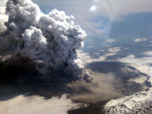 |
Figure 1. Photograph of Okmok by flight attendant Kelly Reeves during Alaska airlines flight on 13 July 2008. Image courtesy of Alaska Airlines. |
Ash erupted from a vent or vents near composite cinder cone called Cone D in the eastern portion of the 9.7-km wide caldera. Activity during the past three significant eruptions (1945, 1958, and 1997) occurred from Cone A, a cinder cone on the far western portion of the caldera floor. Each of the three previous eruptions was generally mildly to moderately explosive with most ash clouds produced rising to less than 9.1 km altitude. Each eruption also produced a lava flow that traveled about 5 km across the caldera floor.
AVO reported that during 15-16 July seismicity changed from nearly continuous to episodic volcanic tremor, and the overall seismic intensity declined. Little to no ash was detected by satellite, but meteorological clouds obscured views. Satellite imagery from 0533 on 16 July indicated elevated surface temperatures in the NE sector of the caldera. On 16 July, a light dusting of ash was reported in Unalaska/Dutch Harbor. A plume at an altitude of 9.1 km was visible on satellite imagery at 0800. On 17 July, a pilot reported that an ash plume rose to altitudes of 4.6-6.1 km and drifted E and NE. The sulfur dioxide plume had drifted at least as far as eastern Montana (figure 2). On 18 July, the eruption was episodic, with occasional ash-producing explosions occurring every 15 to 30 minutes. The plumes from these explosions were limited to about 6.1 km.
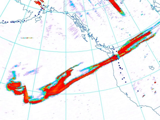 |
Figure 2. OMI composite image from NOAA showing the extent of the sulfur dioxide gas cloud from the eruption of Okmok imaged at about 1200 AKDT on 17 July, 2008. The large mass shows the location of the high altitude sulfur dioxide cloud from the main explosive phase on 12 July 2008. Image created by Rick Wessels (AVO); courtesy of the OMI near-real-time decision support project funded by NASA. |
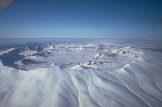
Geological Summary. The basaltic Okmok shield volcano forms the NE end of Umnak Island in the Aleutian Islands. The summit of the low, 35-km-wide volcano is cut by two overlapping 10-km-wide calderas formed during eruptions about 12,000 and 2,050 years ago when dacitic pyroclastic flows reached the coast. More than 60 tephra layers from Okmok have been found overlying the 12,000-year-old caldera-forming tephra layer. Numerous cones and lava domes are present on the flanks down to the coast, including the SE-flank Mount Tulik, which is almost 200 m higher than the caldera rim. Some of the post-caldera cones show evidence of wave-cut lake terraces; more recent cones were formed after the caldera lake, once 150 m deep, disappeared. Eruptions have been reported since 1805 from cinder cones within the caldera, where there are also hot springs and fumaroles.
Information Contacts: Alaska Volcano Observatory (AVO), a cooperative program of the U.S. Geological Survey, 4200 University Drive, Anchorage, AK 99508-4667, USA; Geophysical Institute, University of Alaska, PO Box 757320, Fairbanks, AK 99775-7320, USA; and Alaska Division of Geological & Geophysical Surveys, 794 University Ave., Suite 200, Fairbanks, AK 99709, USA (URL: http://www.avo.alaska.edu/); Associated Press (URL: http://www.ap.org/).