Report on Llaima (Chile) — June 2008
Bulletin of the Global Volcanism Network, vol. 33, no. 6 (June 2008)
Managing Editor: Richard Wunderman.
Llaima (Chile) Summary of January-February 2008 eruption; minor eruptions late March-early April 2008
Please cite this report as:
Global Volcanism Program, 2008. Report on Llaima (Chile) (Wunderman, R., ed.). Bulletin of the Global Volcanism Network, 33:6. Smithsonian Institution. https://doi.org/10.5479/si.GVP.BGVN200806-357110
Llaima
Chile
38.692°S, 71.729°W; summit elev. 3125 m
All times are local (unless otherwise noted)
A report from OVDAS-SERNAGEOMIN (Volcanological Observatory of the Southern Andes ? National Service of Geology and Mining) by Naranjo, Peña, and Moreno (2008) summarized the eruption at Llaima of January through February 2008. This and other reports from OVDAS-SERNAGEOMIN supplements earlier reports (BGVN 33:01) and extends observations through late April 2008.
Summary of January-February 2008 eruption. Shortly after 1730 (local time) on 1 January 2008, Llaima began a new eruptive cycle that was very similar in character to a large eruption that had occurred in February 1957. The 2008 activity was centered at the principal crater, a feature 350 x 450 m in diameter with the major axis trending NW-SE. This new continuous eruptive phase began with strong Strombolian eruptions. Strong ejections of lava fragments fell on the glaciers on the high flanks NE and W of the principal cone (figure 18), generating lahars that flowed ~15 km to reach the Captrén River to the N and the Calbuco River to the W (figure 19). The eruptive plume rose to an altitude of ~ 11 km and blew ESE; ash accumulated to a depth of ~11 cm at a distance of 7 km from the crater.
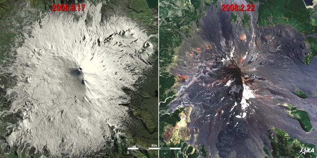 |
Figure 18. Satellite images depicting Llaima before and after the recent eruptions. The left image shows Llaima on 17 September 2006 covered with a white blanket of snow and ice; the right image shows Llaima on 22 February 2008 after numerous eruptions, with ash covering the remnants of the glacier. Courtesy of the Japan Aerospace Exploration Agency-Earth Observation Research Center (JAXA-EORC) Advanced Land-Observing Satellite (ALOS) website. |
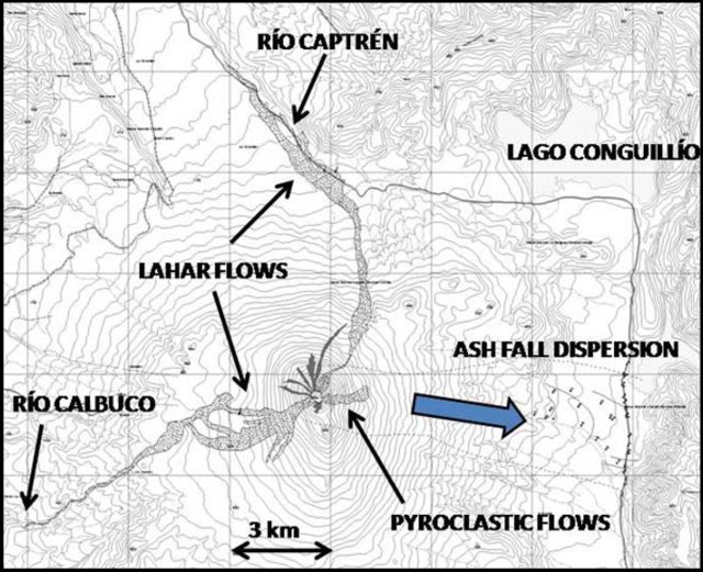 |
Figure 19. Map showing areas of principal effects of the eruption at Llaima on 1 January 2008. Courtesy of OVDAS-SERNAGEOMIN. |
The 1 January 2008 phase was preceded by a slight increase in tremor and a swarm of low frequency earthquakes, but with an absence of volcano-tectonic (VT) or hybrid (HB) events. On 2 January 2008, the activity began to decline. However, a plume of sulfur dioxide (SO2) was tracked by satellite (figure 20).
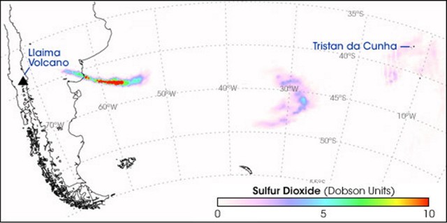 |
Figure 20. A plume of sulfur dioxide (SO2) was released on 2 January 2008. The initially intense plume thinned as it moved E. On 4 January 2008, the plume passed over Tristan da Cunha. This image, acquired by the Ozone Monitoring Instrument (OMI) on NASA's Aura satellite, shows the progress of that plume from 2-4 January 2008. OMI measures the total column amount of SO2 in Dobson Units. (If all the SO2 in a column of atmosphere is compressed into a flat layer at standard temperature (0°C) and pressure (1 atmosphere), a single Dobson Unit of SO2 would measure 0.01 mm in thickness and would contain 0.0285 grams of SO2/m2.) Courtesy, NASA Earth Observatory website. |
An explosion on 7 January 2008 resulted in an ash plume that rose 5 km above the crater and traveled E toward Argentina. This explosion was associated with a low frequency, large magnitude event.
On 9 January, a series of explosions occurred. The seismicity included a swarm of low frequency, high-amplitude events and an abrupt increase in microseismicity that decreased gradually until 14 January and more slowly thereafter. On 18 January, after discrete low frequency tremors, explosions from the crater resulted in a pyroclastic flow on the upper E flank (figure 21).
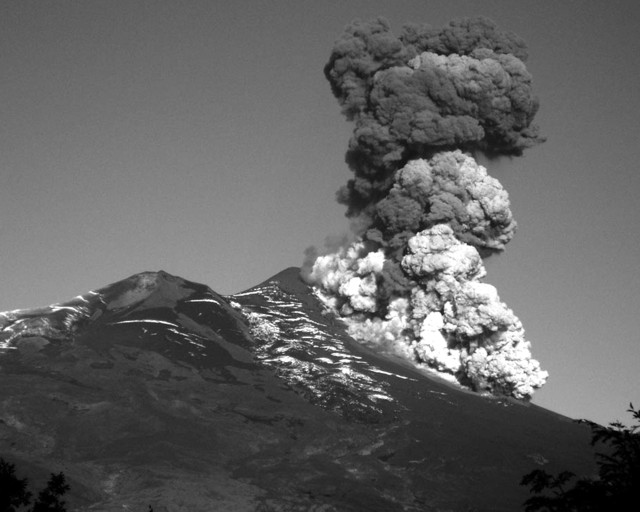 |
Figure 21. Pyroclastic flow on Llaima's E flank on 18 January 2008. Courtesy, OVDAS-SERNAGEOMIN and Gentileza M. Yarur. |
On 21 January seismic activity increased. This was followed on 25 January by continuous Strombolian activity in the main crater. During the night of 26 January, a significant increase in activity occured. Pyroclastic-flow deposits were noted during 28 January on the E flank.
A lava lake that had formed in the main crater began to overflow the W rim on 3 February and a lava flow descended for 2.5 km, making channels in the ice tens of meters deep. The 'a'a lava flow, which was 30-40 m wide and 10 m thick, lasted until 13 February.
Between 8-13 February, explosions in the main crater propelled incandescent material 200-500 m in the air. Explosions occasionally alternated between N and S cones in the main crater. On 9 February, the Calbuco River was about 1 m higher than the normal level, likely due to melt water from the lava and glacier interaction. Strombolian eruptions from the main crater were observed during an overflight on 10 February. A strong explosion ejected bombs onto the E and NE flanks of the volcano on 12 February. Then, on 13 February, incandescence at the summit was noted. Thereafter seismic activity decreased, with only sporadic low frequency signals. The volcano was quiet until 21 February, when a small explosion occurred. Pyroclastic flows were also observed on 21 February descending the E and possibly the W flanks.
During the January-February eruptive phase, various types of plumes were observed, including steam plumes, sulfur dioxide plumes, small ash plumes, and ash-and-gas plumes. The Alert Level remained at Yellow.
March-April 2008. Fumarolic activity from the central pyroclastic cone in Llaima's main crater reactivated on 13 March and intensified during 15-17 March. SO2 plumes rose to an altitude of 3.6 km and drifted E. During 20-21 March, incandescent material propelled from the crater was observed at night.
During 28 March-4 April, fumarolic plumes from Llaima drifted several tens of kilometers, mainly to the SE. Explosions produced ash and gas emissions, and on 4 April, incandescence was reflected in a gas-and-ash plume. An overflight of the main crater on 2 April revealed pyroclastic material and ash and gas emissions, accompanied by small explosions, that originated from three cones.
On 24 April 2008, seismicity from Llaima again increased. Bluish gas (SO2) rose from the main crater, and ash-and-gas plumes associated with explosions rose to an altitude of 4.6 km. No morphological changes to the summit were observed during an overflight on 25 April except for a small increase of the diameter of the SE crater.
Thermal anomalies. Thermal anomalies measured by MODIS in 2008 began with an eruption on 1 January 2008 (BGVN 33:01) and continued almost daily through 13 February (table 3). Following a brief period of no measured anomalies, a new group occurred 30 March through 4 April, after which none were recorded through 1 June 2008. Advanced Spaceborne Thermal Emission and Reflection Radiometer (ASTER) images and reports by ground observers from Projecto Observación Visual Volcán Llaima (POVI) indicated incandescence at the volcano during periods when no anomalies were measured by the MODIS satellites (19-21 March and 24 April 2008), perhaps due to cloud cover. All periods of reported incandescence by ground observers during January 2008 were substantiated by MODIS measured thermal anomalies.
Table 3. MODIS thermal anomalies over Llaima from February through 1 June 2008; data processed by MODVOLC analysis. Daily anomalies were measured from 1-13 February 2008, followed by no anomalies through 29 March. After a period of anomalies from 30 March through 4 April 2008, none were measured through 1 June 2008. Some absences may be due to weather. Courtesy of HIGP Thermal Alerts System.
| Date | Time (UTC) | Pixels | Satellite |
| 01 Feb 2008 | 0305 | 2 | Terra |
| 01 Feb 2008 | 0620 | 2 | Aqua |
| 01 Feb 2008 | 1405 | 1 | Terra |
| 01 Feb 2008 | 1820 | 1 | Aqua |
| 02 Feb 2008 | 0345 | 2 | Terra |
| 02 Feb 2008 | 0525 | 1 | Aqua |
| 02 Feb 2008 | 1450 | 2 | Terra |
| 03 Feb 2008 | 0250 | 4 | Terra |
| 03 Feb 2008 | 0430 | 4 | Terra |
| 03 Feb 2008 | 0605 | 2 | Aqua |
| 03 Feb 2008 | 1355 | 1 | Terra |
| 03 Feb 2008 | 1535 | 2 | Terra |
| 03 Feb 2008 | 1810 | 1 | Aqua |
| 04 Feb 2008 | 0335 | 4 | Terra |
| 04 Feb 2008 | 0510 | 6 | Aqua |
| 04 Feb 2008 | 1850 | 2 | Aqua |
| 05 Feb 2008 | 0415 | 2 | Terra |
| 05 Feb 2008 | 0555 | 4 | Aqua |
| 05 Feb 2008 | 1520 | 2 | Terra |
| 06 Feb 2008 | 0320 | 3 | Terra |
| 06 Feb 2008 | 0500 | 3 | Aqua |
| 06 Feb 2008 | 0640 | 4 | Aqua |
| 06 Feb 2008 | 1425 | 2 | Terra |
| 07 Feb 2008 | 0405 | 4 | Terra |
| 07 Feb 2008 | 0545 | 2 | Aqua |
| 07 Feb 2008 | 1510 | 2 | Terra |
| 08 Feb 2008 | 0625 | 6 | Aqua |
| 08 Feb 2008 | 1415 | 3 | Terra |
| 09 Feb 2008 | 0350 | 3 | Terra |
| 09 Feb 2008 | 0530 | 6 | Aqua |
| 09 Feb 2008 | 1455 | 2 | Terra |
| 09 Feb 2008 | 1910 | 2 | Aqua |
| 10 Feb 2008 | 0255 | 4 | Terra |
| 10 Feb 2008 | 0435 | 4 | Aqua |
| 10 Feb 2008 | 0615 | 5 | Aqua |
| 10 Feb 2008 | 1540 | 4 | Terra |
| 11 Feb 2008 | 0340 | 4 | Terra |
| 11 Feb 2008 | 0520 | 4 | Aqua |
| 11 Feb 2008 | 1445 | 5 | Terra |
| 11 Feb 2008 | 1855 | 1 | Aqua |
| 12 Feb 2008 | 0425 | 4 | Terra |
| 12 Feb 2008 | 0600 | 7 | Aqua |
| 12 Feb 2008 | 1525 | 5 | Terra |
| 12 Feb 2008 | 1940 | 4 | Aqua |
| 13 Feb 2008 | 0330 | 2 | Terra |
| 13 Feb 2008 | 0645 | 2 | Aqua |
| 30 Mar 2008 | 0340 | 1 | Terra |
| 01 Apr 2008 | 0505 | 1 | Aqua |
| 02 Apr 2008 | 0550 | 1 | Aqua |
| 04 Apr 2008 | 0400 | 1 | Terra |
| 04 Apr 2008 | 0535 | 2 | Aqua |
Reference. Naranjo, J.A., Peña, P., and Moreno, H., 2008, Summary of the eruption at Llaima through February 2008: National Service of Geology and Mining (Servico Nacional de Geologia y Mineria - SERNAGEOMIN).
Geological Summary. Llaima, one of Chile's largest and most active volcanoes, contains two main historically active craters, one at the summit and the other, Pichillaima, to the SE. The massive, dominantly basaltic-to-andesitic, stratovolcano has a volume of 400 km3. A Holocene edifice built primarily of accumulated lava flows was constructed over an 8-km-wide caldera that formed about 13,200 years ago, following the eruption of the 24 km3 Curacautín Ignimbrite. More than 40 scoria cones dot the volcano's flanks. Following the end of an explosive stage about 7200 years ago, construction of the present edifice began, characterized by Strombolian, Hawaiian, and infrequent subplinian eruptions. Frequent moderate explosive eruptions with occasional lava flows have been recorded since the 17th century.
Information Contacts: OVDAS-SERNAGEOMIN (Observatorio Volcanológico de los Andes del Sur-Servico Nacional de Geologia y Mineria) (Southern Andes Volcanological Observatory-National Geology and Mining Service), Avda Sta María 0104, Santiago, Chile (URL: http://www.sernageomin.cl/); NASA Earth Observatory (URL: http://earthobservatory.nasa.gov/); Hawai'i Institute of Geophysics and Planetology (HIGP) Thermal Alerts System, School of Ocean and Earth Science and Technology (SOEST), Univ. of Hawai'i, 2525 Correa Road, Honolulu, HI 96822, USA (URL: http://modis.higp.hawaii.edu/); Buenos Aires Volcanic Ash Advisory Center (VAAC), Servicio Meteorológico Nacional-Fuerza Aérea Argentina, 25 de mayo 658, Buenos Aires, Argentina (URL: http://www.smn.gov.ar/vaac/buenosaires/productos.php); POVI (Projecto Observación Visual Volcán Llaima) (Project of Visual Observation of Llaima Volcano) (URL: http://www.povi.cl/llaima/); Japan Aerospace Exploration Agency-Earth Observation Research Center (JAXA-EORC) (URL: http://www.eorc.jaxa.jp/); ONEMI (Oficina Nacional de Emergencia - Ministerio del Interior) (National Bureau of Emergency - Ministry of Interior), Chile (URL: http://www.onemi.cl/).