Report on Chaiten (Chile) — June 2008

Bulletin of the Global Volcanism Network, vol. 33, no. 6 (June 2008)
Managing Editor: Richard Wunderman.
Chaiten (Chile) Events of June-July include diminished plumes, substantial seismicity, and lateral blast
Please cite this report as:
Global Volcanism Program, 2008. Report on Chaiten (Chile) (Wunderman, R., ed.). Bulletin of the Global Volcanism Network, 33:6. Smithsonian Institution. https://doi.org/10.5479/si.GVP.BGVN200806-358041
Chaiten
Chile
42.8349°S, 72.6514°W; summit elev. 1122 m
All times are local (unless otherwise noted)
Follow previous reports of May 2008 activity (BGVN 33:04, 33:05), this report summarizes Chaitén's behavior from 31 May through 25 July 2008. The bulk of this report came from SERNAGEOMIN (Servicio Nacional de Geología y Minería) and to some extent ONEMI (Oficina Nacional de Emergencia - Ministerio del Interior). A web camera located on a tower in Chaitén town and aimed upstream along the Blanco (Chaitén) river has helped authorities assess both the state of the volcano's plumes and the river (see URL in Information Contacts). In a later section are included some descriptions and photos by Richard Roscoe taken on 9 July.
On 3 June it was reported that lateral blasts or surges (or related processes) had devastated ~ 25 km2 of native forest. Other behavior during this interval included consistent ash plumes, which were generally present when the volcano was visible, and continued growth of the intracrater dome and tephra cone. Vent areas and the dome and tephra cone's morphology changed as the dome grew more elongate.
The late May to early June behavior included a short-term seismic decrease, and a weakened eruptive column. During the reporting interval, the column was often noticeably weaker than in early May, but the seismicity was still relatively high. The two main seismic instruments monitoring the volcano (figure 13) registered numerous sustained events through late July, which began to cluster NNE of Chaitén. Some of the earthquakes were up to M 2.6.
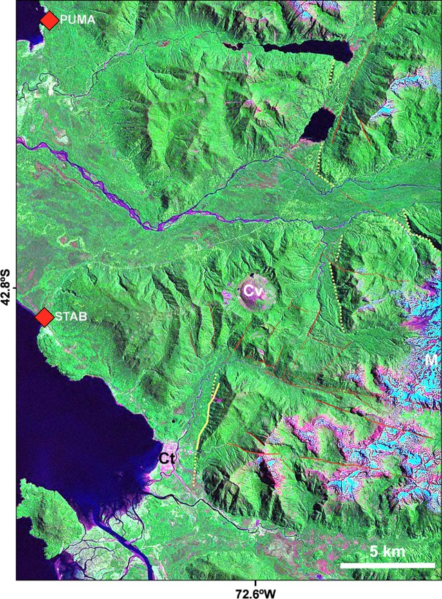 |
Figure 13. Monitoring instrumentation includes two telemetered seismic stations, PUMA (short for Pumalín) and STAB (short for Santa Barbara), which sit adjacent the coast and monitor Chaitén volcano (Cv). On 12 July the stations detected two earthquakes centered NE of the volcano along a major fault trace there (the Liquiñe-Ofqui fault system). The colored versions of the map distinguish second-order faults, which mostly have left-lateral kinematics (red lines), and eroded scarps (yellow lines). Snow-covered Michinmahuida stratovolcano is also a prominent feature (M, along the E margin of map), as is the town of Chaitén (Ct). Courtesy of Luis E. Lara. |
SERNAGEOMIN repeatedly interpreted the earthquakes to signify magma ascending from depth. If this magma reached the surface, they noted, vigorous eruptions might return. The high-viscosity of rhyolitic magmas seen here increases potential explosivity. This rhyolitic eruption at Chaitén is the first historically at a monitored volcano. The last significant rhyolitic eruption was at Novarupta volcano in Alaska in 1912.
Chaitén town has largely survived the lahars thus far. A deeper concern is that the growing dome and tephra cone sent bouncing rocks and smaller debris into the caldera's moat. In an early July SERNAGEOMIN report, the authors noted that the caldera's breach, located on the S, appeared blocked by recently eroded products. Small lakes were also then seen on the crater floor. Since the moat area drains to the S through this breach and feeds into the Blanco river, temporary dams in the moat area might seal the caldera's outflow, only to suddenly fail and release large volumes of debris towards the town. Despite this concern, as of 25 July such an event had been absent; however, on 12 July a sudden flood struck Chaitén town (see below).
Activity during June 2008. On 1 June, Chaitén's plume blew W, affecting Chiloé island (including the towns of Queilen, Lebjn, Chonchi, Dalcahue, and Castro, the island's capital). These conditions thwarted work on the seismic network. On 2 June dense fog affected the Gulf of Corcovado, especially adjacent Chiloé island, an atmosphere attributed to remobilization of air-fall ash by wind. That day, a helicopter managed to take off and the view enabled scientists to see an eruptive column to no higher than 3.0 km altitude dispersing SSE.
Seismicity on 2 July was higher than the previous days. Abundant were VT earthquakes, followed by long- period (LP) earthquakes. Between 1 and 2 July, seismic stations registered an average of 5 VT earthquakes per hour (below M 2). At some stations, some of the LP signals were sporadic, lasting less than a minute.
A 5 June SERNAGEOMIN report noted that explosions diminished gradually. Although ash was present, vapor dominated the emissions. A 3 June aerial inspection revealed that the dome's volume and footprint had increased, although it still had not reached the caldera's N wall.
The effects of N and NE flank blasts (or surges, pyroclastic flows, or related processes) were noted during aerial observations from the 3 June flight. The surges had scorched and burned an area of native forest. On this day observers computed an estimate of the damaged area, ~ 2,500 hectares (~ 25 km2). An undated photo looking down on part of the destruction appeared in BGVN 33:05 and more photos appear below. Several SERNAGEOMIN reports mentioned small pyroclastic flows during early and mid-May (12 May in particular, BGVN 33:05). Bulletin editors take the 3 June estimate as reflecting the sum of all devastation to that point in time.
On 3 and 4 June the plume's top stood below 3 km altitude. A 10 June SERNAGEOMIN report noted the continued lowered eruptive and seismic intensity through that time. Plumes continued to remain under 3 km altitude and they still affected air travel.
On 12 June observers at Chaitén town noticed tephra-bearing emissions. Noises had emanated from the volcano that day and the previous one. The SERNAGEOMIN report associated these emissions with two new vents seen on the S flank of the old dome, where craters had developed. Vapor-rich plumes had emerged from these areas and the observers inferred that the vents were possibly due to magma-water interactions. In addition, sudden floods swept into Chaitén town in the afternoon on 12 June, despite a lack of evidence for greater rains across the region. They were inferred as related to the emissions the same day.
Seismicity beneath the volcano on 12 June increased in the morning both in terms of the number of earthquakes and their magnitudes. Most of these events were less than M 2. Two prominent earthquakes struck ~ 5 km farther NE of the volcano, along the Liquiñe-Ofqui fault zone.
The 22 June report noted that observers looking at the contact between the old and new domes had seen two craters there that emitted ash plumes. The observers also noted near-source falls of both blocks and ash.
The same report said that a 17 June aerial inspection documented an ash plume to over 2 km over the volcano's summit that blew N and NW. Roars and associated noise from the eruption included the sound of an explosion at 1430 on 17 June. The resulting column rose to a height above the summit of over 3 km but later dropped to 2 km. Emissions continued from a crater S of the contact between the old and new domes. Immediately to the W of this crater, a new and growing crater issued increasingly large emissions of ash and gas. Numerous smaller vents were also apparent, chiefly emitting steam. Loose material covered parts of the old dome, forming a ring-shaped structure (a tephra cone). That structure's steep sides and inner and outer walls occasionally underwent mass wasting. Poor weather during 19-25 June halted aerial inspections then, but ash fell in Chaitén town and to the W and SE, as well as Queilen and other portions of E Chiloé island.
Following 20 June, seismicity remained stable with ~ 40-45 earthquakes per day. Sporadic numbers of VT earthquakes took place; there was no change in the number of LP earthquakes. Investigators inferred a lack of pressure increase in the volcanic system. During bad weather on 23-25 June some earthquakes again occurred on the Liquiñe-Ofqui fault zone, with epicenters in an area 2-3 km E of the volcano. A power outage struck midday on 25 June. A back-up power supply (UPS) worked for a while, but ultimately the outage caused several hours of lost seismic data at the Queilen processing center. Available data suggested a small increase in both the number and amplitudes of earthquakes during 24-25 June. During 0000-1200 on 25 June, instruments recorded 35 VT earthquakes, and four of those were M 2.2; LP earthquakes were absent.
Seismicity during the days leading up the SERNAGEOMIN report issued on 27 June reflected VT earthquakes generally below M 2, reaching 50 per day. An exception was on the 25th when four earthquakes exceeded M 2.0.
July 2008. On 1 July an ash column rose ~ 3 km above the top of the new dome. It blew N and NE. An aerial observation at close hand discerned two roughly vertical, sub-parallel eruption plumes issuing from vents in the crater. One plume, most active in recent weeks, came from a sector S of the new dome. The second plume came from a sector more to the W of the new dome. A photo of the scene in the 3 July SERNAGEOMIN report also depicted the area of eruption largely engulfed in white clouds from numerous fumaroles on the dome. On 3 July SERNAGEOMIN began a series of reports on unrest at Llaima stratovolcano (which went to Red alert on 10 July). Around 16 July a weather front also moved in across the Chiloé island region. Consecutive SERNAGEOMIN reports discussing Chaitén were only issued on 3 and 21 July, with a lack of much discussion on that volcano for the interval 3-15 July.
During 15-20 July seismicity stood relatively high, with an average of 350-400 VT earthquakes per day. On 20 July more than 20 earthquakes surpassed M 2.6. The next reports noted that on 21 and 22 July VT earthquakes occurred 330 times per day; 60 of those were near M 2.6, and that the number of earthquakes decreased on 24 July. Still, some of the minor earthquakes reached M 2.6 and were detected up to 300 km away. Seismic data around this time were interpreted to reflect magma at depth moving towards the surface, possibly implying a reactivation of the system, although the earthquake's depth was poorly constrained.
Chaitén's plume blew E at ~ 2 km altitude above the summit and appeared weaker than usual when seen as the weather cleared after 1500 on 23 July. During 22-24 July, earthquakes had increased both in number and magnitude, with the largest M ~ 2.6.
A new area of epicenters appeared during 22 and 23 July at a location 6 km ENE of the volcano. Seismic stations located 176 and 296 km from Chaitén, respectively monitoring the volcanoes Calbuco and Puyehue-Cordón Caulle, recorded these events, the first such occurrence since the eruption began. Previously, conspicuous epicenters had mainly occurred to the S and SE. Preliminary hypocenter calculations suggested the larger earthquakes in this NNE area were deeper, at 10-15 km depth.
Arrival times of S- and P-waves at stations Pumalín and Santa Bárbara indicated that the smaller magnitude earthquakes still occurred S and SE of Chaitén, whereas the larger magnitude earthquakes struck in the area 6 km ENE. An inspection flight carried viewers to the N and NE of the volcano on 24 July where they saw that the single active central vent sat to the S of the new dome. The emissions then were intermittent, white, and ash poor. When strongest, a thin plume rose to under 2 km altitude, with strong winds causing dispersion to the S and SE. When viewed on 24 July, the new dome also contained a significant depression in the S sector, at a point immediately N of the main active vent mentioned above. This depression emitted steam and gases. The new dome seemed to have decreased its growth rate, at least in the N sector. Strong steaming emerged from base of the dome's E sector. The observers looked around the new dome on the NW, N and NE sides, and they saw neither ponded areas nor lakes. During 24-27 July, the ash column rose to 2.5 km and occasionally 3.0 km altitude. The most active vent was the previously mentioned one located S of the new dome. The plume blew N and NW where it affected various localities along the coast.
Floating pumice. By early June, the white pumice from the eruption accumulated at river mouths to the volcano's W. Some fragments of pumice were as large as 40 cm in diameter. In addition to the Blanco river, those carrying the pumice included the Yelcho and Negro (respectively entering the sea 2 km and 5 km S of Chaitén town). Pumice rafts in the Gulf were seen in May (BGVN 33:05). During June and at least early July, along beaches of Chiloé (and particularly at Lelbjn, 12 km N of Queilen, a town almost directly W of Chaitén town) floating pumice continued to arrive. This area lies 60-100 km across Corcorvado gulf from the mouth of the Blanco river at Chaitén town. The pumice deposits, which included tree trunks and other debris, covered a thin zone along the shoreline stretching ~ 20 m from the sea's edge when photographed the afternoon of 1 July.
Roscoe's July 2008 photos. One of the subjects Roscoe presented on his PhotoVolcanica website was Chaitén's N devastated area, and some of those photos appear here (figures 14 and 15). The captions were brief and omitted the direction the camera was aimed. He visited the devastated area on 9 July 2008.
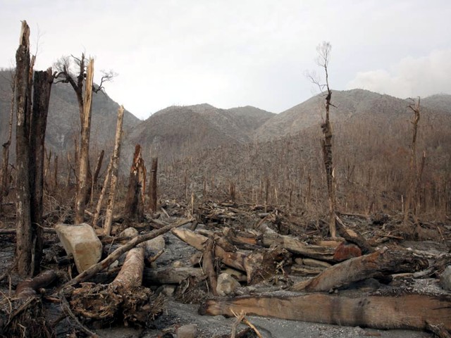 |
Figure 14. One of the parts of the devastation zone containing large lithic blocks (~ 1 m across), the most conspicuous being the one at left, which may have been perched above fallen timber. Trees here fell away from the viewer. Courtesy of Richard Roscoe, PhotoVolcanica.com. |
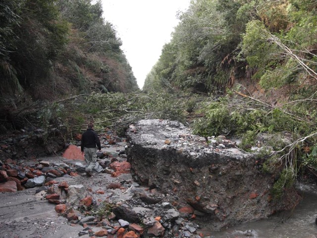 |
Figure 15. Drainages redirected by Chaitén's eruption caused erosion of this road to the volcano's N. Courtesy of Richard Roscoe, PhotoVolcanica.com. |
Roscoe noted that in the area he photographed, "Most trees were snapped off a couple of meters above the ground. The [pyroclastic] flow does not appear to have been hot enough to burn the leaves off the trees at the point we visited at the base of the volcano. Many branches with brown leaves were lying around. Very little pumice was found in the area although much of it may have been swept away during subsequent heavy rainfall."
In Chaitén town, Roscoe documented damage-mitigation and salvaging efforts (figure 16). Two of Roscoe's photos showed heavy equipment (a large backhoe and a bulldozer) reshaping the lahar deposits in an attempt to control encroaching lahars. Other scenes included people retrieving belongings, excavating lahar deposits covering the floor and lower shelves of a grocery store, and improving drainage from and access to their homes.
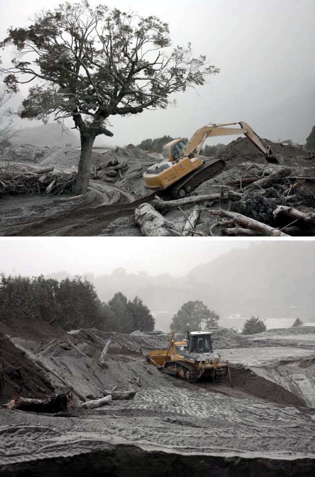 |
Figure 16. Work in Chaitén town to strengthen river banks to protect town from lahars. Although laden with tree trunks, the lahars appear quite uniform in color and character, devoid of coarse lithics or large rafted pumices. Courtesy of Richard Roscoe, PhotoVolcanica.com. |
Geological Summary. Chaitén is a small caldera (~3 km in diameter) located 10 km NE of the town of Chaitén on the Gulf of Corcovado. Multiple explosive eruptions throughout the Holocene have been identified. A rhyolitic obsidian lava dome occupies much of the caldera floor. Obsidian cobbles from this dome found in the Blanco River are the source of artifacts from archaeological sites along the Pacific coast as far as 400 km from the volcano to the N and S. The caldera is breached on the SW side by a river that drains to the bay of Chaitén. The first recorded eruption, beginning in 2008, produced major rhyolitic explosive activity and building a new dome and tephra cone on the older rhyolite dome.
Information Contacts: Servicio Nacional de Geología y Minería(SERNAGEOMIN), Avda Sta María No 0104, Santiago, Chile (URL: http://www.sernageomin.cl/); Oficina Nacional de Emergencia - Ministerio del Interior (ONEMI), Beaucheff 1637 / 1671, Santiago, Chile (URL: http://www.onemi.cl/); Luis E. Lara, Departamento de Geología Aplicada, SERNAGEOMIN; Richard Roscoe, Photovolcanica.com (URL: http://www.photovolcanica.com/).