Report on Chikurachki (Russia) — August 2008
Bulletin of the Global Volcanism Network, vol. 33, no. 8 (August 2008)
Managing Editor: Richard Wunderman.
Chikurachki (Russia) Explosive eruptions in July-August 2008
Please cite this report as:
Global Volcanism Program, 2008. Report on Chikurachki (Russia) (Wunderman, R., ed.). Bulletin of the Global Volcanism Network, 33:8. Smithsonian Institution. https://doi.org/10.5479/si.GVP.BGVN200808-290360
Chikurachki
Russia
50.324°N, 155.461°E; summit elev. 1781 m
All times are local (unless otherwise noted)
The previous eruption at Chikurachki (figure 7) began in March 2007 (BGVN 32:05) and ended in November 2007 (BGVN 33:03). According to the Tokyo VAAC, based on observations of satellite imagery, eruptive activity resumed on 29 July 2008. KVERT reported that an ash plume rose to an altitude of 6.1 km and drifted more than 30 km WSW; during 30-31 July ash plumes drifted S.
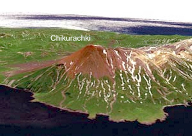 |
Figure 7. Digital model of the relief of Chikurachki created from a LANDSAT 7 (satellite) image. View is toward the SW. Created by D.V. Melnikov. |
Seismicity was imperfectly known because Chikurachki is not monitored with a dedicated seismometer. One telemetered seismic station resides on Alaid volcano, 58 km NNW (figure 8).
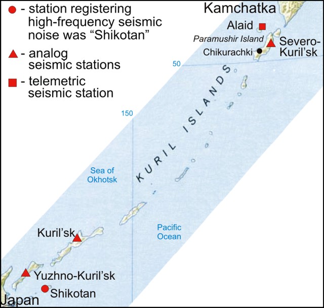 |
Figure 8. Map showing seismic stations in Kuril islands used to monitor Chikurachki. The terms Severo and Yuzhno mean "North" and "South." respectively. Compiled from multiple sources by Bulletin editors. |
Eruptive activity continued during 1-8 August (figure 9); ash plumes drifted more than 60 km SE, W, and N. During 1-3 August the plume rose to an altitude of 2.7 km. There were no confirmed ash eruptions after 8 August.
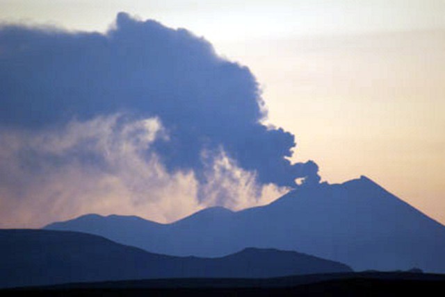 |
Figure 9. Explosive eruption of Chikurachki showing an ash plume extending SE on 2 August 2008. Photo by A. Gruzevich (Russian Federal Research Institute of Fisheries and Oceanography). |
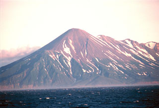
Geological Summary. Chikurachki, the highest volcano on Paramushir Island in the northern Kuriles, is a relatively small cone constructed on a high Pleistocene edifice. Oxidized basaltic-to-andesitic scoria deposits covering the upper part of the young cone give it a distinctive red color. Frequent basaltic Plinian eruptions have occurred during the Holocene. Lava flows have reached the sea and formed capes on the NW coast; several young lava flows are also present on the E flank beneath a scoria deposit. The Tatarinov group of six volcanic centers is located immediately to the south, and the Lomonosov cinder cone group, the source of an early Holocene lava flow that reached the saddle between it and Fuss Peak to the west, lies at the southern end of the N-S-trending Chikurachki-Tatarinov complex. In contrast to the frequently active Chikurachki, the Tatarinov centers are extensively modified by erosion and have a more complex structure. Tephrochronology gives evidence of an eruption around 1690 CE from Tatarinov, although its southern cone contains a sulfur-encrusted crater with fumaroles that were active along the margin of a crater lake until 1959.
Information Contacts: Kamchatka Volcanic Eruptions Response Team (KVERT), Institute of Volcanology and Seismology (IVS), Far East Division, Russian Academy of Sciences, Piip Ave. 9, Petropavlovsk-Kamchatsky, 683006, Russia (URL: http://www.kscnet.ru/ivs/); Dmitriy Melnikov, KVERT, Russia; Tokyo Volcanic Ash Advisory Center (VAAC), Tokyo, Japan (URL: https://ds.data.jma.go.jp/svd/vaac/data/); Anatoliy Gruzevich, Russian Federal Research Institute of Fisheries and Oceanography (VNIRO),Federal State Unirtary Enterprise, 17, V. Krasnoselskaya Str., Moscow, 107140, Russia (URL: http://www.vniro.ru/en/).