Report on Barren Island (India) — November 2008

Bulletin of the Global Volcanism Network, vol. 33, no. 11 (November 2008)
Managing Editor: Richard Wunderman.
Barren Island (India) Ash plumes and thermal alerts continue through 2008
Please cite this report as:
Global Volcanism Program, 2008. Report on Barren Island (India) (Wunderman, R., ed.). Bulletin of the Global Volcanism Network, 33:11. Smithsonian Institution. https://doi.org/10.5479/si.GVP.BGVN200811-260010
Barren Island
India
12.278°N, 93.858°E; summit elev. 354 m
All times are local (unless otherwise noted)
As previously reported (BGVN 33:06), thermal anomalies on Barren Island detected by MODIS instruments and processed by the MODVOLC system ceased during 6 October 2007 to 11 May 2008 but then went on to register through the end of June 2008. Thermal anomalies remained frequent, and sometimes daily, through the end of the year (figure 14). Some days displayed five or more alerts per day, with the most active day, 20 November 2008, having 12 alert pixels. Although the likely cause of those near-daily thermal anomalies was ongoing eruptions, the island's remoteness and uninhabited setting precludes continuous eye-witness reporting. A new dissertation discusses volcanic rocks on Barren Island (Alam, 2008), and a technical paper on the topic is in review.
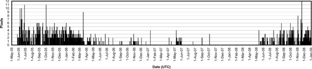 |
Figure 14. Daily thermal anomalies at Barren Island from the MODIS/MODVOLC satellite observations, May 2005 through December 2008. Vertical scale indicates the daily number of alert pixels detected in a specific thermal image, generally a reflection of the extent of hot lava flows. Anomalies are from both the Aqua and Terra satellites, and use UTC dates. Courtesy of the HIGP MODIS Thermal Alert System. |
On 17 November 2008 the Darwin Volcanic Ash Advisory Center (VAAC) reported pilot observations of lava flows on Barren Island, but no visible incandescence or vapor. A possible low-level ash plume was seen on satellite imagery drifting W. On 19 November, a pilot reported that an ash plume rose to an altitude of ~ 2.5 km and drifted WSW. During 7-8 December, the Darwin VAAC again reported pilots observations of lava flows on Barren Island. Although thermal anomalies were detected on satellite imagery, ash plumes were not visible.
Reference. Mohammad Ayaz Alam, 2008, Geological, geochemical and geothermal studies on the Barren Island volcano, Andaman Sea, Indian Ocean: Ph.D. dissertation, Indian Institute of Technology Bombay, Mumbai, India.
Geological Summary. Barren Island, a possession of India in the Andaman Sea about 135 km NE of Port Blair in the Andaman Islands, is the only historically active volcano along the N-S volcanic arc extending between Sumatra and Burma (Myanmar). It is the emergent summit of a volcano that rises from a depth of about 2250 m. The small, uninhabited 3-km-wide island contains a roughly 2-km-wide caldera with walls 250-350 m high. The caldera, which is open to the sea on the west, was created during a major explosive eruption in the late Pleistocene that produced pyroclastic-flow and -surge deposits. Historical eruptions have changed the morphology of the pyroclastic cone in the center of the caldera, and lava flows that fill much of the caldera floor have reached the sea along the western coast.
Information Contacts: Hawai'i Institute of Geophysics and Planetology (HIGP) Thermal Alerts System, School of Ocean and Earth Science and Technology (SOEST), Univ. of Hawai'i, 2525 Correa Road, Honolulu, HI 96822, USA (URL: http://modis.higp.hawaii.edu/); Darwin Volcanic Ash Advisory Centre (VAAC), Bureau of Meteorology, Northern Territory Regional Office, PO Box 40050, Casuarina, NT 0811, Australia (URL: http://www.bom.gov.au/info/vaac/).