Report on Tofua (Tonga) — February 2009
Bulletin of the Global Volcanism Network, vol. 34, no. 2 (February 2009)
Managing Editor: Richard Wunderman.
Tofua (Tonga) Intermittent observations and thermal alerts in 2004 and 2007-2009 indicate activity
Please cite this report as:
Global Volcanism Program, 2009. Report on Tofua (Tonga) (Wunderman, R., ed.). Bulletin of the Global Volcanism Network, 34:2. Smithsonian Institution. https://doi.org/10.5479/si.GVP.BGVN200902-243060
Tofua
Tonga
19.75°S, 175.07°W; summit elev. 515 m
All times are local (unless otherwise noted)
An increased number of satellite-based MODVOLC thermal alerts occurred at Tofua (figure 1) on nine days during March to November 2008, as compared with alerts on three days in 2004, none in 2005 or 2006, two days in 2007, and one day in 2009 (as of 5 April). All of these infrared-derived alerts have been in the same area, a zone several kilometers N of the lake near the 5-km-diameter caldera's N rim, a region where numerous cones and craters reside. One or more of those cones was steaming in a 1990 image. In that image, this area appears steep and largely rocky, an unlikely location for repeated fires (figure 2). Eyewitness views of glow, scoria and spatter ejections from in the crater of Lofia cone during 1993, 2004, and 2009 suggest that at least some if not all the MODVOLC alerts are credible signatures reflecting the minimum level of volcanism at Tofua.
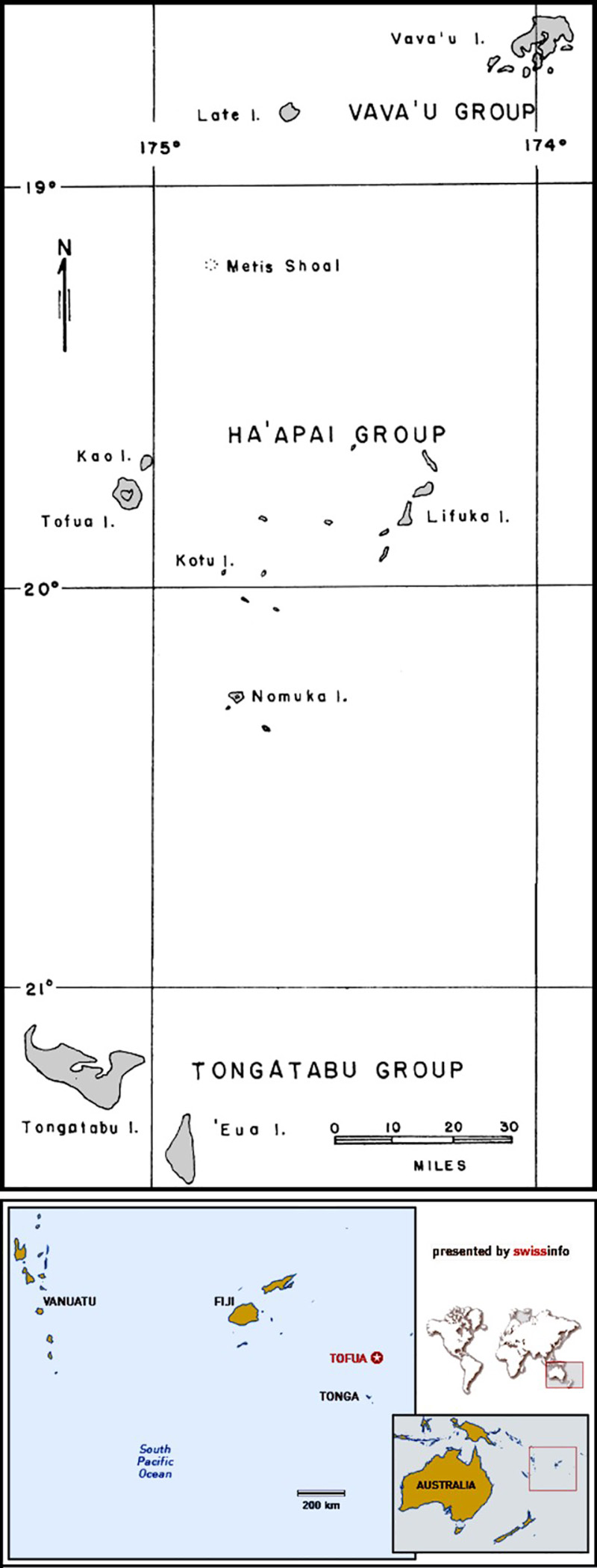 |
Figure 1. A set of index maps and a larger map of the main part of the Tonga Archipelago. The latter shows the location of Tofua Island in the western part of the Ha'apai Island Group. From Bauer (1970). |
 |
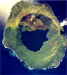
Figure 2. Aerial photograph of Tofua volcano showing the steaming Lofia cinder cone. Courtesy of the Tonga Ministry of Lands, Survey, and Natural Resources, 1990 (published in Taylor and Ewart, 1997). |
Previous reports in the Bulletin on Tofua covered aspects of activity during portions of 1979, 2000, and 2006 (SEAN 04:06, 04:12; BGVN 26:12, and 31:06, respectively). Taylor and Ewart (1997) compiled a chronology of Tongan eruptions.
Observations during 1993. Mary Lyn Fonua sent the following summary regarding a visit to Tofua in 1993. "It was quite a long time ago that we did a photographic feature on Tofua in May 1993 for our Eva magazine. Pesi, my husband, went there on [29 April 1993] on a two seater amphibian aircraft piloted by Peter Goldstern that landed on the crater lake. There was a smoking vent on the side of the volcano and thick yellowish smoke pouring out of the wall of the crater. They felt the island rumbling. There were hot thermal pools to bathe in. I seem to remember Pesi saying that ... it was possible to see a glow from volcanic activity in the crater at night. About 10 people were living on the island at the time, on the southern tip of the island .... There was forest and scrub on some parts of the island."
The above description of visible glow presumably came from the Lofia vent area just N of the lake. Vegetation and permanent or itinerant inhabitants suggests that some of the outlying thermal alerts discussed below might have been false-positives due to fires. Nicole Keller, of Woods Hole Oceanographic Institution, also notes that Tongans often communicate from island to island using fires.
Observations during 2004. Nicole Keller sent the following information about her October 2004 visit. "The only fumaroles were located inside Lofia crater?not at all accessible. None of the other, smaller cones around Lofia were active in any way (no obvious signs of degassing, no sulfur smell), but definitely had some alteration features that suggest they were hydrothermally altered in the past. Every few minutes there was a rumbling, and every now and again (1-time to 2-times per hour) there was a bigger explosion projecting juvenile scoria over the crater rim." Similar activity was seen by John Caulfield in May 2006 (BGVN 31:06), but without the scoria showers.
MODVOLC Thermal Alerts, 2004-2009. Satellite thermal data over Tofua revealed the absence of thermal alerts between 30 May 2004 and 18 March 2007. The MODVOLC alerts mentioned above began 19 March 2004 (table 1 and figure 3). The maps reveal repeating alerts at and adjacent to the N-caldera cone (Lofia). The October 2004 in situ observations from Keller confirm that the 19 March and 10 and 29 May 2004 MODVOLC alerts were probably due to volcanism. Given the pattern of small ongoing eruptions from a deep crater at Lofia as discussed by visitors during 1993, 2004, and at some point during 2008-2009, it is likely most of the MODVOLC alerts reflect volcanism at Tofua.
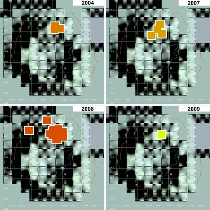 |
Figure 3. Graphic depiction (by year) of satellite thermal alerts (MODVOLC) for Tofua volcano from 19 March 2004 through 6 April 2009. No alerts were measured between 30 May 2004 and 14 March 2007. Images show alerts during 2004, 2007, 2008, and 2009. Courtesy of HIGP Thermal Alerts System. |
Table 1. Satellite thermal alerts (MODVOLC) for Tofua volcano from 19 March 2004 through 6 April 2009. No alerts were measured between 30 May 2004 and 14 March 2007. Courtesy of HIGP Thermal Alerts System.
| Date (UTC) | Time (UTC) | Pixels | Satellite |
| 19 Mar 2004 | 1020 | 1 | Terra |
| 10 May 2004 | 1300 | 1 | Aqua |
| 29 May 2004 | 1025 | 1 | Terra |
| 15 Mar 2007 | 0125 | 1 | Aqua |
| 22 May 2007 | 1025 | 3 | Terra |
| 07 Mar 2008 | 1015 | 1 | Terra |
| 07 Mar 2008 | 1320 | 1 | Aqua |
| 21 Jun 2008 | 1050 | 2 | Terra |
| 21 Jun 2008 | 2145 | 1 | Terra |
| 22 Jun 2008 | 1305 | 2 | Aqua |
| 23 Jun 2008 | 1040 | 1 | Terra |
| 04 Jul 2008 | 1020 | 1 | Terra |
| 22 Aug 2008 | 0140 | 1 | Aqua |
| 23 Aug 2008 | 0045 | 1 | Aqua |
| 20 Nov 2008 | 1310 | 2 | Aqua |
| 21 Nov 2008 | 1045 | 1 | Terra |
| 08 Mar 2009 | 1030 | 1 | Terra |
The HIGP Thermal Alerts System listed approximately 190 pixels ~ 45 km SE of Tofua Island on 17 January 2009. Rob Wright of the MODIS/MODVOLC team explained that these were artifacts over the ocean due to reflected sunlight (see http://modis.higp.hawaii.edu/daytime.html). "The last field in the MODVOLC text alert file is a sunglint vector. When this number is over 12 degrees it means that the MODIS sensor was 'looking' within 12 degrees of the specular angle (like being blinded by a mirror when the sun-mirror-eye angle is just right). In this case the mirror is the water surface. We leave them off the map because they are not real hot-spots. We leave them in the text alert file because our 12 degree threshold errs on the side of caution, and other workers may want to use a less restrictive threshold." On the date in question the glint vector was between 1 and 3.
Observations during March 2009. Swiss adventurer Xavier Rosset reported a clear description of minor eruptive activity at Tofua. His audio dialog, posted 13 March 2009, referred to his visit to the active cone during the preceding week, although the exact date of observation was unclear. At that time the crater was about 80-100 m deep and the same in diameter. Three openings of undetermined size displayed an orange glow. Lava ejections from these vents rose 10-50 m high and were accompanied by loud noises. Photos taken by Rosset (figures 4 and 5) show the active cone with lava in the bottom. Rosset's 27 March 2009 dialog discusses a strong earthquake in the region (Mw 7.6 on 20 March, centered ~ 45 km SE of Tofua), which caused several rockfalls on the island. He visited the volcano in the afternoon and, looking into the active crater, saw few noticeable changes.
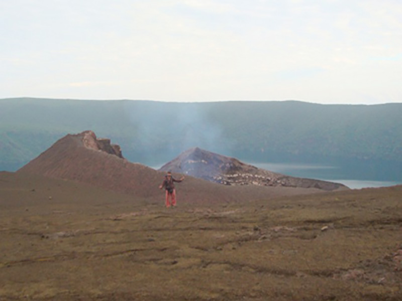 |
Figure 4. Photo of Xavier Rosset in front of the active Lofia cinder cone at Tofua, March 2009. The caldera lake resides in the background. Courtesy of X. Rosset. |
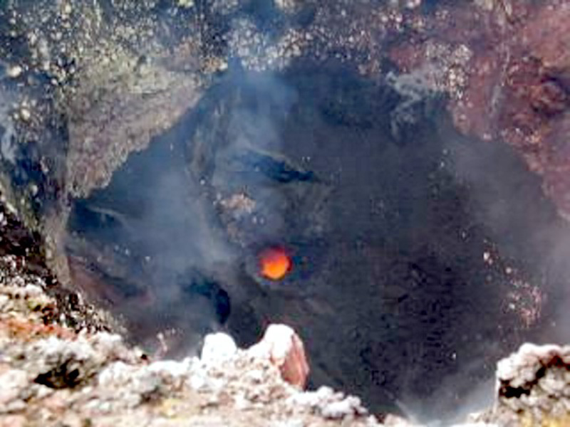 |
Figure 5. Photo looking down into the vertical-walled Lofia crater to an orange-colored, circular zone of lava on the floor, March 2009. Courtesy of X. Rosset. |
References. Bauer, G.R., 1970, The Geology of Tofua Island, Tonga: Pacific Science, v. 24, no. 3, p. 333-350.
Morrison, C., 29 May 2008, Xavier Rosset, 300 days alone on an island: The Islomaniac website (http://www.the-islomaniac.com/).
Taylor, P.W., and Ewart, A., 1997, The Tofua Volcanic Arc, Tonga, SW Pacific: a review of historic volcanic activity: Aust Volc Invest Occ Rpt, 97/01, 58 p.
Geological Summary. The low, forested Tofua Island in the central part of the Tonga Islands group is the emergent summit of a large stratovolcano that was seen in eruption by Captain Cook in 1774. The summit contains a 5-km-wide caldera whose walls drop steeply about 500 m. Three post-caldera cones were constructed at the northern end of a cold fresh-water caldera lake, whose surface lies only 30 m above sea level. The easternmost cone has three craters and produced young basaltic andesite lava flows, some of which traveled into the caldera lake. The largest and northernmost of the cones, Lofia, has a steep-sided crater that is 70 m wide and 120 m deep and has been the source of historical eruptions, first reported in the 18th century. The fumarolically active crater of Lofia has a flat floor formed by a ponded lava flow.
Information Contacts: Hawai'i Institute of Geophysics and Planetology (HIGP) Thermal Alerts System, School of Ocean and Earth Science and Technology (SOEST), Univ. of Hawai'i, 2525 Correa Road, Honolulu, HI 96822, USA (URL: http://modis.higp.hawaii.edu/); Mary Lyn Fonua, Matangi Tonga Online, Vava'u Press Ltd., Tonga (URL: http://www.matangitonga.to/); Xavier Rosset (URL: http://www.xavierrosset.com/); Paul W. Taylor, Australian Volcanological Investigations, P.O. Box 291, Pymble, NSW, 2073 Australia; Nicole S. Keller, Department of Geology and Geophysics, Woods Hole Oceanographic Institution, Woods Hole, MA, USA.