Report on Redoubt (United States) — April 2009
Bulletin of the Global Volcanism Network, vol. 34, no. 4 (April 2009)
Managing Editor: Richard Wunderman.
Redoubt (United States) First eruption since 1989-1990; over19 explosions; growth of new lava dome
Please cite this report as:
Global Volcanism Program, 2009. Report on Redoubt (United States) (Wunderman, R., ed.). Bulletin of the Global Volcanism Network, 34:4. Smithsonian Institution. https://doi.org/10.5479/si.GVP.BGVN200904-313030
Redoubt
United States
60.485°N, 152.742°W; summit elev. 3108 m
All times are local (unless otherwise noted)
The previous eruption of Redoubt that began on 14 December 1989 (SEAN 14:11) lasted until June 1990. On 15 March 2009, an eruption again occurred, after changes in gas emissions, seismicity, and heat output were noted during the previous 8 months (BGVN 33:11).
As background, in late July 2008, Alaska Volcano Observatory (AVO) crews working near the summit smelled hydrogen sulfide (H2S) gas. About a month later, a pilot reported a strong sulfur-dioxide (SO2) odor, and nearby residents heard noises coming from the direction of Redoubt. Scientists also observed several fractures and circular openings in the upper Drift Glacier, and they found fumaroles atop the 1968 and 1990 lava domes more vigorous than when last observed in mid-August 2008. On 13 October 2008, satellite instruments detected warming at the summit, and on 2 November a slushy debris-flow originated near the 1966-68 vent. On 16 December 2008 a short-lived steam cloud rose no higher than the volcano's summit.
The rest of this report discusses unrest starting in late January 2009, and gives a brief overview of the eruption from the first ash-bearing explosions detected on 15 March, through those continuing during mid-May. Figure 18 shows a map of the area; the volcano sits along the Cook Inlet ~ 80 km WSW of Anchorage (see also figure 12 in BGVN 15:04; and Waythomas and others, 1998).
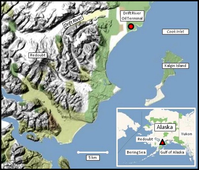 |
Figure 18. Shaded relief map of the Redoubt area, indicating both the Drift river and the oil terminal with the same name. A sketch map of the Drift river oil terminal. Base maps courtesy of Google Maps; feature locations courtesy of USGS-AVO. |
During 24-25 January 2009, Redoubt's seismicity increased markedly and steam and sulfurous gases were noted. On 25 January, tremor became sustained and amplitude increased notably. Steaming increased at previously identified vent areas in the snow and ice cover, which also emitted sulfurous gas. An overflight on 26 January revealed elevated SO2 emissions from the summit and new outflows of muddy debris along the glacier that is downslope of the summit. Seismicity was variable during the last few days of January extending into early March, but it remained above background levels. Observations revealed increased fumarolic activity, enlarged melt features in the summit glacier, and increased runoff from along the margins of the Drift glacier, which feeds the river system of the same name down Redoubt's N-flank (figure 18). Steam plumes within the summit crater were seen on the web camera.
The 2009 eruption began with a minor ash-and-steam explosion just after 1300 on 15 March; major explosions began at about 2240. The emissions originated from a new vent, located just S of the 1990 lava dome and W of the prominent ice collapse feature near the N edge of the summit crater. A sediment-laden flow occurred from a small area in the ice on the upper part of Drift glacier (figure 19).
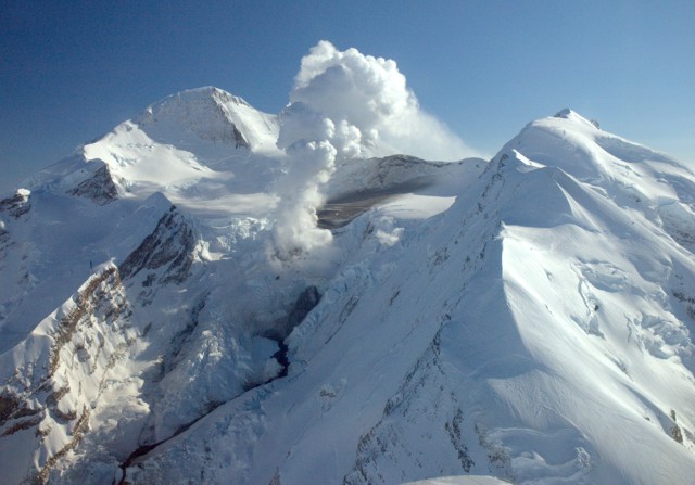 |
Figure 19. Photograph of Redoubt's N face taken about 35 minutes after the ash burst of 15 March 2009 during a monitoring flight. A dark area of fresh ash deposits lies on top of the snow on the sloping crater floor. In front of that a gas plume escapes from a vent near the crater rim. The sinuous dark stripe in the foreground is a watery debris flow that emerged from beneath the ice about 20 minutes after the ash event. Photo by Heather Bleick; courtesy of USGS-AVO. |
During 15 March-4 April, AVO recorded more than 19 separate explosions and reported that ash plumes exceeded altitudes of 15.2 km. The largest explosion occurred at 0555 on 4 April. This explosion lasted more than 30 minutes, and was comparable in size to the largest event of the 1989-1990 eruption. The explosion produced an ash plume that rose to an altitude of 15.2 km and drifted SE. [However, the highest plume during this time rose to almost 20 km altitude, on 26 March.]
The eruptions caused melting of the Drift Glacier and greatly increased discharge, causing lahars in the Drift River that traveled more than 35 km, reaching the Cook Inlet. On 23 March, AVO staff saw large lahar and flood deposits in the Drift River valley. In the middle to upper Drift River valley, high-water marks reached 6-8 m above the valley floor. Some of these deposits were observed on 30 April (figure 20).
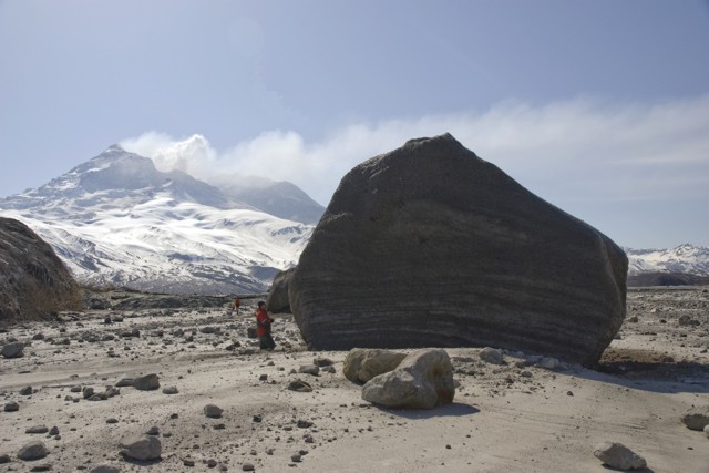 |
Figure 20. Image taken on 30 April 2009 showing several the large blocks of glacial ice deposited in the Drift River valley during the flood caused by the eruptive event on 4 April 2009. The N shoulder of the western end of Dumbbell Hills is on left side of image. The high-water mark near this site was nearly 10 m. Note the geologist standing to the left of the largest block for scale. Photo by Game McGimsey, courtesy of USGS-AVO. |
Several of the explosions resulted in ashfall in several populated areas, as far away as Delta Junction (~ 545 km NE). More significant ashfall occurred in more contiguous areas, including the Matanuska-Susitna Valley, the Kenai Peninsula and the Anchorage bowl. Satellite images showed a broad layer of volcanic haze that extended over these areas. On 22 March, ashfall was reported in areas 190-250 km NE. According to a 29 March Associated Press article, flights in and out of Anchorage and other local areas were canceled or diverted during 24-28 March. As many as 185 Alaska Airlines flights had been canceled since the beginning of the eruption; airports and other airlines also experienced service disruptions. The maximum thickness of ashfall measured in a populated area was about 1.5 mm near Seldovia, following the 4 April explosion. A measurement of about 3 mm, following the explosion on 26 March, was recorded near Silver Salmon Creek Lodge, about 48 km S. Trace ashfall was also observed between explosive events, during times when the volcano emitted continuous low-altitude (under 4.6 km) gas-and-ash plumes.
On 30 March a thermal anomaly at the vent seen on satellite imagery was caused by the extrusion of a lava dome in the summit crater (confirmed by AVO on 3 April). Observers also recognized that the dome had already began spilling occasional avalanches of hot blocks a short distance down the N flank. Observations on 9 April determined that the lava dome, which had grown in the same location as the previous one, was circular in shape, and 400 m in diameter. By 16 April, the lava dome was estimated to be about 500 x 700 m across and at least 50 m thick (figure 21). A volume estimate of the still-expanding dome made during 29 April-5 May suggested a volume of 25-30 million cubic meters.
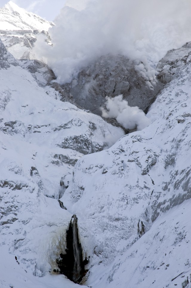 |
Figure 21. Image from 16 April 2009 of the active lava dome that grew in Redoubt's summit crater. The steam plume near the base of the dome comes from a pocket where abundant hot blocks shedding off the dome accumulated. The waterfall (dark area in lower part of photo) is ~ 75 m high. Photo by Game McGimsey, courtesy of USGS-AVO. |
After the last explosion detected on 4 April and until mid-May, small steam-and-gas plumes occasionally containing some ash were seen on satellite imagery and on the web camera. Elevated seismicity and satellite imagery indicated that the lava dome continued to grow. SO2 plumes were also detected by satellite imagery. Occasional rockfalls originating from the lava dome's flanks were observed on the web camera.
Reference. Waythomas, C.F., Dorava, J.M., Miller, T.M., Neal, C.A., and McGimsey, R.A., 1998, Preliminary volcano-hazard assessment for Redoubt volcano, Alaska: USGS Open File report 97-857, plate 1.
Geological Summary. Redoubt is a glacier-covered stratovolcano with a breached summit crater in Lake Clark National Park about 170 km SW of Anchorage. Next to Mount Spurr, Redoubt has been the most active Holocene volcano in the upper Cook Inlet. The volcano was constructed beginning about 890,000 years ago over Mesozoic granitic rocks of the Alaska-Aleutian Range batholith. Collapse of the summit 13,000-10,500 years ago produced a major debris avalanche that reached Cook Inlet. Holocene activity has included the emplacement of a large debris avalanche and clay-rich lahars that dammed Lake Crescent on the south side and reached Cook Inlet about 3,500 years ago. Eruptions during the past few centuries have affected only the Drift River drainage on the north. Historical eruptions have originated from a vent at the north end of the 1.8-km-wide breached summit crater. The 1989-90 eruption had severe economic impact on the Cook Inlet region and affected air traffic far beyond the volcano.
Information Contacts: Alaska Volcano Observatory (AVO), a cooperative program of a) U.S. Geological Survey, 4200 University Drive, Anchorage, AK 99508-4667, USA (URL: http://www.avo.alaska.edu/), b) Geophysical Institute, University of Alaska, PO Box 757320, Fairbanks, AK 99775-7320, USA, and c) Alaska Division of Geological & Geophysical Surveys, 794 University Ave., Suite 200, Fairbanks, AK 99709, USA; Associated Press (URL: http://www.ap.org/).