Report on West Mata (Tonga) — June 2009
Bulletin of the Global Volcanism Network, vol. 34, no. 6 (June 2009)
Managing Editor: Richard Wunderman.
West Mata (Tonga) Submarine effusive and explosive eruption seen at two vents in May 2009
Please cite this report as:
Global Volcanism Program, 2009. Report on West Mata (Tonga) (Wunderman, R., ed.). Bulletin of the Global Volcanism Network, 34:6. Smithsonian Institution. https://doi.org/10.5479/si.GVP.BGVN200906-243130
West Mata
Tonga
15.1°S, 173.75°W; summit elev. -1174 m
All times are local (unless otherwise noted)
This is the first Bulletin report on West Mata, a small seamount ~ 200 km SW of Samoa, the scene of inferred ongoing eruptions when visited during November 2008 and an unambiguous eruption at multiple vents when visited during May 2009. West Mata is located in the NE Lau basin ~ 35 km E of the closest portion of the Lau spreading center (figure 1) and ~ 70 km NE of a now-erupting portion of the NE Lau spreading center (NELSC). Investigations of this site were made on two research cruises conducted in the region by the research ressel RV Thompson during November 2008 and May 2009.
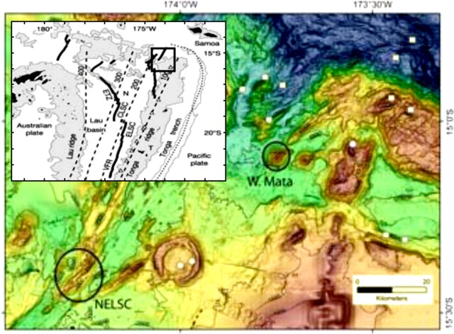 |
Figure 1. Bathymetric map of NE Lau area showing two eruption areas (circled) discovered during the 2009 expedition, West Mata and NELSC where volcanoes Tafu and Maka are located. Contour interval 500 m. Inset location map shows the Fiji Islands (~ 860 km WNW) and Samoa (~ 270 km NE), along with the East Lau Spreading Center (ELSC), Central Lau Spreading Center (CLSC), and Fonulalei Spreading Center (FSC). Courtesy of Resing and others (2009). |
Expedition during 13-28 November 2008. During the 2008 expedition, water column measurements were made, including a conductivity, temperature, and depth (CTD) rosette package to characterize the physical and chemical nature of hydrothermal systems. The RV Thompson's multibeam sonar provided high-resolution bathymetry and seafloor backscatter imagery. West Mata volcano (figure 2) was very likely erupting lava flows and/or pyroclastic material at this time. The intense plume rising ~ 175 m from the summit that was characterized by high values of turbidity, hydrogen, delta helium-3 (d3He), oxidation-reduction potential (Eh), and pH. The acoustic backscatter over portions of the volcano was uniformly high, indicating geologically young seafloor.
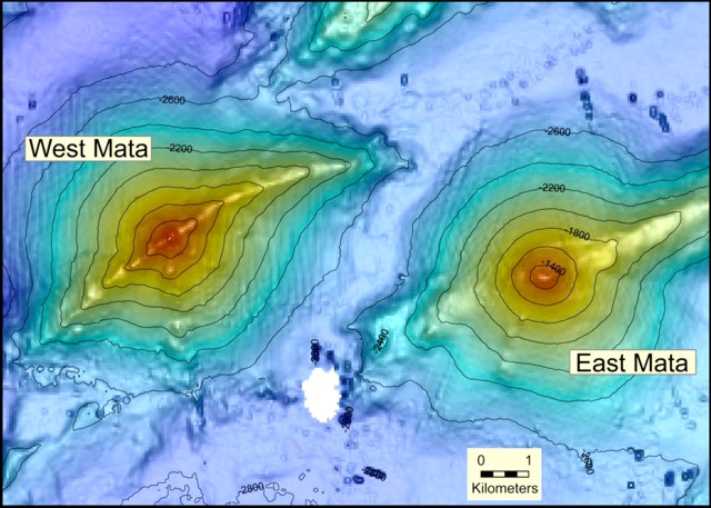 |
Figure 2. Multibeam bathymetry of West and East Mata volcanoes. Contour interval is 200 m. Taken from Resing and others (2009). |
Although the marine optical backscatter was dominated by elemental sulfur and particulate iron, there was also an abundance of large mineral and/or glass shards in the plume. The larger clastic materials were composed almost exclusively of Mg-silicates, with lesser Ca-Mg-silicates. These compositions were consistent with the eruption of boninites (glass olivine-bronzite andesite that contains little or no feldspar) that previously have only been observed at inactive volcanoes. These chemical and geological characteristics match well with those of NW Rota-1 in the southern Mariana arc, which has been undergoing submarine Strombolian eruptions for at least 4 years (BGVN 29:03, 31:05, and 33:02).
Resing and others (2009) reported that the acoustic backscatter appeared to show extensive deposits of clastic material draping the volcano and extending over a recent lava flow at its eastern end, suggesting a recent and continuous state of eruption. Finally, they note that East Mata (figure 3), a similar volcano ~ 10 km closer to the Tofua arc, is also hydrothermally active, albeit less intense than West Mata.
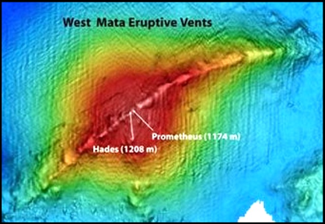 |
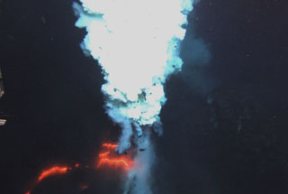
Figure 3. The two Jason ROV dives at West Mata volcano discovered not just one active volcanic vent, but two, Hades and Prometheus. Both vents were obscured much of the time by billowing sulfurous gas emissions, but bright orange lava was seen in both vents. The orange glowing lava was visible for minutes at a time. Text courtesy of Dave Clague (on expedition blog); bathymetric chart courtesy of NOAA Vents website. |
Expedition during 5-13 May 2009. On 6-7 May, scientists onboard the RV Thompson used the Jason 2 ROV (remotely operated vehicle) to observe eruptions from two vents of West Mata (figure 3), Prometheus (at or near the summit) and Hades (slightly to the SW). According to Dave Clague, writing on the expedition blog, the deeper vent, Hades, sits on the SW rift. It was erupting both effusively and explosively at the same time on both days (6-7 May). Small bursts were occurring at one end of an erupting fissure ~ 5 m long at a depth of 1,208 m, while pillow lavas were being extruded from the other end. By the next night (7 May) the activity had become more vigorous, sometimes blowing glowing bubbles as much as a meter across from the fissure.
Clague noted that the second, shallower vent, Prometheus, was located very near the summit of the volcano and about 100 meters away from Hades, the first vent. The eruption here was entirely explosive with low-level, but nearly continuous fire fountains throwing ejecta into the water during both dives. Both vents were often obscured by sulfur gas emissions, but incandescence was visible for minutes at a time. According to an article on the Discovery News website, Jason 2 approached the vent and was promptly buried in ~ 45 kg of debris. Huge gas bubbles, maybe 1 m in diameter, were observed coming out of West Mata.
References. Resing, J., Lupton, J., Embley, R., Baker, E., and Lilley, M. (compilers), 2009, Preliminary findings from the North Lau eruption sites, informal report, 2/5/09 (URL: http://www.ridge2000.org/science/downloads/email/Nlaupreliminaryfindings25.pdf).
Geological Summary. West Mata, a submarine volcano rising to within 1,174 m of the ocean surface, is located in the northeastern Lau Basin at the northern end of the Tofua arc, about 200 km SW of Samoa and north of the Curacoa submarine volcano. Discovered during a November 2008 NOAA Vents Program expedition it was found to be producing submarine hydrothermal plumes consistent with recent lava effusion. A return visit in May 2009 documented explosive and effusive activity from two closely spaced vents, one at the summit, and the other on the SW rift zone.
Information Contacts: 2009 Lau Basin Eruption Exploration Expedition (blog), NOAA/PMEL VENTS Program (URL: http://laueruptions.blogspot.com/); National Oceanographic and Atmospheric Agency (NOAA) Vents Program (URL: http:/www.pmel.noaa.gov/vents/); Discovery News (URL: http://dsc.discovery.com/news/2009/06/05/undersea-eruption.html).