Report on Paluweh (Indonesia) — June 2009
Bulletin of the Global Volcanism Network, vol. 34, no. 6 (June 2009)
Managing Editor: Richard Wunderman.
Paluweh (Indonesia) April 2009 spike in seismicity but no explosive activity or visible emissions
Please cite this report as:
Global Volcanism Program, 2009. Report on Paluweh (Indonesia) (Wunderman, R., ed.). Bulletin of the Global Volcanism Network, 34:6. Smithsonian Institution. https://doi.org/10.5479/si.GVP.BGVN200906-264150
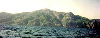
Paluweh
Indonesia
8.32°S, 121.708°E; summit elev. 875 m
All times are local (unless otherwise noted)
During 1-17 April 2009, seismicity increased at Paluweh (table 1), prompting the Center of Volcanology and Geological Hazard Mitigation (CVGHM) to raise the Alert Level from 1 to 2 (Waspada) on 18 April. CVGHM staff in the observation post did not see any gas or ash emissions. Visitors were requested to stay away from the active crater adjacent to the peak.
Table 1. Average number of daily seismic events recorded from Paluweh, April 2009. Courtesy of CVGHM.
| Date | Deep volcanic earthquakes (daily average) | Shallow volcanic earthquakes (daily average) |
| 01-03 Apr 2009 | 2 | 2 |
| 04-05 Apr 2009 | 17 | 18 |
| 06-10 Apr 2009 | 6 | 11 |
| 11-13 Apr 2009 | 6 | 10 |
| 14-15 Apr 2009 | 22 | 10 |
| 16 Apr 2009 | 23 | 15 |
Explosive activity had most recently been observed in May 1984 and previously during November 1980-September 1981 (SEAN 06:01, 06:02, 06:08, and 06:09), October 1973, and October 1972-January 1973. Activity in December 1963-March 1966 included lava flows, pyroclastic flows, and fatalities.
An unconfirmed news report of activity in January 2005, not reported in the Bulletin, was later found to be false. The CVGHM staff found no activity at the volcano.
As background on hazard considerations, the mouth of the principal crater opens to the S, where there is plantation agriculture almost to the volcano's peak. In the advent of a future crisis, evacuation would be complicated because a safer area is about two hours journey by motor vessel, and leaving the island might not be possible during storms or rough seas. CVGHM is in continuous contact with the provincial and regional governments, some monitor of Paluweh occurs from the hamlet of Ropa on the N-central coast of the big island of Flores, to Paluweh's S. Regional civil-defense agencies (such as SATKORLAK-PB, the Provincial Coordinating Unit for Disaster Management) and district government agencies of Sikka and Ende (such as SATLAK-PB, the Local Coordinating Body for Disaster Relief) are continually apprised of the activity level.
Geological Summary. Paluweh, also known as Rokatenda, forms the 8-km-wide island of Palu'e north of the volcanic arc that cuts across Flores Island. The broad irregular summit region contains overlapping craters up to 900 m wide and several lava domes. Several flank vents occur along a NW-trending fissure. A large eruption in 1928 included strong explosive activity accompanied by landslide-induced tsunamis and lava dome emplacement. Pyroclastic flows in August 2013 resulted in fatalities.
Information Contacts: Center of Volcanology and Geological Hazard Mitigation (CVGHM), Jalan Diponegoro 57, Bandung 40122, Indonesia (URL: http://vsi.esdm.go.id/).