Report on Tengger Caldera (Indonesia) — March 2011
Bulletin of the Global Volcanism Network, vol. 36, no. 3 (March 2011)
Managing Editor: Richard Wunderman.
Tengger Caldera (Indonesia) Ongoing emissions, 2004-2011
Please cite this report as:
Global Volcanism Program, 2011. Report on Tengger Caldera (Indonesia) (Wunderman, R., ed.). Bulletin of the Global Volcanism Network, 36:3. Smithsonian Institution. https://doi.org/10.5479/si.GVP.BGVN201103-263310
Tengger Caldera
Indonesia
7.942°S, 112.95°E; summit elev. 2329 m
All times are local (unless otherwise noted)
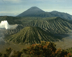
Tengger Caldera contains the frequently erupting Bromo cone, which has repeatedly erupted since about the year 1590. Under normal conditions, Bromo emits a white, sparse-to- dense vapor reaching heights of 75-150 m above the rim, with an acrid smell of sulphur. Our last report noted the eruption on 8 June 2004 (BGVN 29:07); small plumes and seismic signals suggestive of emissions continued through the previous reporting interval, which ended 18 July 2004. According to a December 2010 report from the Center of Volcanology and Geological Hazard Mitigation (CVGHM), during 1994, 1996, 2000, and 2004, Bromo's eruptions ejected glowing lava that fell in the vicinity of the crater. The countryside around Bromo is not densely populated, since it lies within the Bromo-Tengger-Semeru National Park, but the volcano is a popular tourist destination.
On 16 August 2004, due to a decrease in seismic and volcanic activity at Tengger, the Center of Volcanology and Geological Hazard Mitigation (CVGHM) decreased the Alert Level from 2 to 1 (on a scale of 1-4).
The next report we received on Tengger was from the Darwin Volcanic Ash Advisory Center (VAAC), which noted that a small plume was visible on a satellite image on 14 July 2006. No ash was detected.
On 1 September 2006, CVGHM raised the Alert Level for Tengger to 2 due to heightened activity and a strong smell of sulfur. On 9 September, the Alert Level was raised to 3 due to an increase in tremor, but lowered to 2 on 18 September due to decreased activity.
According to CVGHM, during 18-25 June 2007, diffuse but ash-free plumes rose to an altitude of 2.4 km. Nineteen tectonic earthquakes, one local-tectonic earthquake, and continuous tremor with a maximum amplitude of 0.5-1 mm was noted between 11 June-1 July 2007.
No further reports were received until November 2010, when seismicity increased. Volcanic tremor was first detected on 8 November. According to volcanologist and photographer Richard Roscoe (Photovolcanica), tremor became almost continuous by 22 November along with degassing. CVGHM noted that the heights of gas-and-steam plumes increased during the month, from 75 m above the crater during 1-7 November to 100-250 m above the crater during 8-23 November. The Alert Level was raised to 3 on 23 November. Residents and tourists were not permitted within a 3-km-radius of the active crater. Later that night, seismic activity increased, and a white-to-gray plume rose 200-300 m above the crater. The Alert Level was raised to 4. The tourist areas surrounding the volcano was closed.
Bromo erupted on 26 November 2010, triggering the first significant ash emission, according to Richard Roscoe. He noted that the output of ash was high at several stages during the eruption, which led to significant damage to vegetation in downwind areas. According to the Darwin VAAC, on that day the cloud tops reached 13.7 km and volcanic ash was thought to be "entrained into deep convective clouds."
During 27-29 November satellite imagery showed ash plumes drifting 55-165 km at an altitude of 4.3 km. According to a news article (Agence France-Presse), Malang city's domestic airport, 25 km W, closed on 29 November due to ash. Cloud cover prevented observations during 29-30 November.
On 6 December, CVGHM reported that seismicity at Bromo had declined since 30 November, and deformation measurements showed deflation. White-to-gray plumes rose 200-300 m above the crater rim and drifted N. The Alert Level was lowered to 3. Residents and tourists were not permitted within a 2-km-radius of the active crater.
CVGHM reported that during 8-19 December gray-to-brown plumes from Bromo rose 400-800 m above the crater and drifted E, NE, and N. Tremors continued with a maximum amplitude of 17-32 mm. On 19 December, explosions produced an ash plume that rose 2 km above the crater rim. Ashfall was heavy around the crater and was reported in areas as far away as the Juanda Airport (70 km NNW) in Surabaya. The ash damaged agricultural land, affected trees and river valleys, and disrupted the transportation infrastructure. According to the Darwin VAAC, a possible ash plume from Bromo cone rose to an altitude of 6.1 km on 20 December and drifted about 95 km S.
CVGHM noted that between 19-23 December, tremor continued with a maximum amplitude of 5-30 mm, and 17 eruptive earthquakes occurred with a maximum amplitude of 40 mm and a duration of about 17 to167 seconds each. Tiltmeter deformation measurements showed slight inflation (5 microradians) from 25 November to 14 December; from 15 December through at least February 2011, both its radial and tangential components remained relatively stable. Similarly, measurements of deformation using EDM from 25 November to 20 December 2010 showed relative stability.
According to CVGHM, during 20-25 December, gray-to-brown plumes rose 800-1,200 m above the crater and drifted N and NE. Ejected material fell back around the crater. On 25 December, ash and occasional lapilli fell at the Bromo observation post, about 2 km away. The ashfall was about 20 cm thick. A news report (Reuters) indicated that some flights were cancelled on 20 December between Australia and Bali due to ash, but the emitting volcano was not identified. CVGHM noted that the ash had damaged agricultural land and trees on the slopes and in river valleys, and had paralyzed transportation in the Cemoro Lawang area. Heavy rain during this time raised concern for potential lahars and landslides.
During 24-25 December, tremor continued with a maximum amplitude of 15-40 mm. Two eruptive earthquakes were noted, with a maximum amplitude of 40 mm and a duration of 25 seconds.
The Darwin VAAC reported that during 26-27 December an ash plume rose to an altitude of 5.5 km and drifted 150 km NE. Another ash plume rose to an altitude of 4.3 km on 30 December and drifted about 95 km to the E.
CVGHM reported that during 22-23 January 2011, continuous tremor occurred (maximum amplitude 15-38 mm) and gray-to-brown plumes from Bromo rose 400-800 m above the crater and drifted E. Incandescent material was ejected 200 m above the crater and landed as far as 500 m away. The Darwin VAAC reported that on 24 January an ash plume rose to an altitude of 3.7 km and drifted more than 220 km E. The VAAC report noted that CVGHM had confirmed the eruption and observers had sensed elevated sulfur-dioxide gas in the area.
According to news reports (The West Australian, Sydney Morning Herald), ash plumes from Bromo disrupted flights between Australia (Perth, Sydney, Darwin) and Bali during 27-28 January. An ash plume on 28 January rose to an altitude of 5.5 km and drifted 370 km E and SE. Another ash plume on 29 January rose to an altitude of 3.7 km and drifted 93 km E. During 29-31 January, ash plumes rose to an altitude of 3.7 km and drifted 55 km NW.
CVGHM reported that on 5 February volcanic bombs ejected from Bromo were found 1.2-1.4 km from the crater rim. During 5-9 February and 17-18 February, gray-to-brown ash plumes rose 400-800 m above the crater and drifted E and ENE, causing ashfall in nearby villages. Incandescent material was ejected 200-300 m above the crater and landed as far as 500 m away. Roaring and booming noises were noted. Ash fell at the Bromo observation post, and in nearby villages, including Ngadirejo (10 km WNW), Sukapura (14 km NE), and Sumber (18 km E). High-amplitude seismicity and volcanic tremor were detected. During 5-9 February, the maximum amplitude of the tremor was 17-40 mm.
Based on pilot observation, the Darwin VAAC reported that on 9 February an eruption produced a plume that rose to an altitude of 7 km and drifted W. On 11 February satellite imagery showed an ash plume drifting 37 km SE at an altitude of 3 km. Additional ash plumes on 12 February rose to altitudes of 3-7.9 km and drifted 37-167 km NW and SE.
On 10 March 2011, according to CVGHM, ash fell in areas to the E and NE, including in the Probolinggo district (35 km NE). During 18-20 March, 22-25 March, and 29 March-4 April 2011, gray-to-brown ash plumes rose 400-800 m above the crater and drifted in multiple directions. Incandescent material was ejected 300 m above the crater and landed up to 500 m away. Roaring and booming noises were also noted. According to the Darwin VAAC, during 18-20 March, ash plumes rose to an altitude of 3 km and drifted 27-150 km NW, SW, and S. Ash plumes on 27-28 March rose to an altitude of 4.3 km and drifted 55 km NE.
According to Richard Roscoe, activity in mid-March 2011 could be distinguished into largely Strombolian phases accompanied by little ash and variable levels of degassing, and phases during which significant amounts of ash were released. (Roscoe, 2011). Strombolian phases were sometimes accompanied by powerful shockwaves, often after short periods (10-30 seconds) of complete calm, presumably signifying blockage of the vent causing pressure buildup. (Roscoe, 2011).
Photo gallery. Several sets of photos from mid-March 2011 documented substantial ash plumes and multiple incandescent bombs escaping Bromo's crater, in many cases Strombolian eruptions with bombs falling on the upper flanks. Some of the 30-second night exposures had streaks documenting more than 10 bombs.
Richard Roscoe presented an album that also contained considerable text, including references (Roscoe, 2011).
A second set of photos was taken in March 2011 by Indonesian travel consultant Aris Yanto (Yanto, 2011). It shows the eruption in a wide variety of conditions from locations near and at distance from the vent (showing many plumes in profile).
References. Roscoe, R, 2011, Bromo Volcano (Tengger Caldera), Photovolcanoica, 86 photographs (URL: http://www.photovolcanica.com/VolcanoInfo/Bromo/Bromo.html).
Yanto, A, 2011, Mt. Bromo on 17-20 [March], 2011; Aris Yanto's gallery, Picasa Web Albums, 40 photos, 640 x 361 pixels (URL: https://picasaweb.google.com/ndesoadventure/MTBromoOn17202011).
Geological Summary. The 16-km-wide Tengger caldera is located at the northern end of a volcanic massif extending from Semeru volcano. The massive volcanic complex dates back to about 820,000 years ago and consists of five overlapping stratovolcanoes, each truncated by a caldera. Lava domes, pyroclastic cones, and a maar occupy the flanks of the massif. The Ngadisari caldera at the NE end of the complex formed about 150,000 years ago and is now drained through the Sapikerep valley. The most recent of the calderas is the 9 x 10 km wide Sandsea caldera at the SW end of the complex, which formed incrementally during the late Pleistocene and early Holocene. An overlapping cluster of post-caldera cones was constructed on the floor of the Sandsea caldera within the past several thousand years. The youngest of these is Bromo, one of Java's most active and most frequently visited volcanoes.
Information Contacts: Center of Volcanology and Geological Hazard Mitigation (CVGHM), Jalan Diponegoro 57, Bandung 40122, Indonesia (URL: http://vsi.esdm.go.id/); Darwin Volcanic Ash Advisory Centre (VAAC), Bureau of Meteorology, Northern Territory Regional Office, PO Box 40050, Casuarina, NT 0811, Australia (URL: http://www.bom.gov.au/info/vaac/); Agence France-Presse (URL: http://www.afp.com/afpcom/en/); The Sydney Morning Herald (URL: http://www.smh.com.au/); The West Australian (URL: http://au.news.yahoo.com/thewest/); Reuters (URL: http://www.reuters.com/); Richard Roscoe, Photovolcanica (URL: http://www.photovolcanica.com/).