Report on Tofua (Tonga) — July 2011
Bulletin of the Global Volcanism Network, vol. 36, no. 7 (July 2011)
Managing Editor: Richard Wunderman.
Tofua (Tonga) Evidence of ongoing intermittent eruption into 2011
Please cite this report as:
Global Volcanism Program, 2011. Report on Tofua (Tonga) (Wunderman, R., ed.). Bulletin of the Global Volcanism Network, 36:7. Smithsonian Institution. https://doi.org/10.5479/si.GVP.BGVN201107-243060
Tofua
Tonga
19.75°S, 175.07°W; summit elev. 515 m
All times are local (unless otherwise noted)
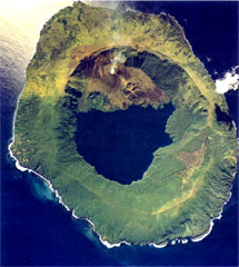
Tofua is a non-instrumented, remote, island volcano that is seldom the subject of reports; it continued to emit at least low-level eruptions well into 2011. This small volcanic island lies in southern Tonga (see map and other figures in BGVN 34:02), ~ 1,700 km NNE of New Zealand. In 1993 there were ~ 10 residents (BGVN 34:02).
Our previous report on Tofua (BGVN 34:02) gave a summary of MODVOLC thermal alert data through March 2009 and discussed data artifacts due to reflected sunlight over the ocean. Since that time, only a single-pixel thermal alert was measured, located at the vent on 4 March 2011.
Sailors visit in 2010. On 24 April 2010, sailors in a replica 7.6-m-long wooden boat landed on the island associated with a re-enactment of the landing made by Captain Bligh after he and his crew were cast off of the Bounty in 1789. A number of photos associated with announcements regarding the 2010 landing and activities on Tofua suggests that the volcano was still active in a manner similar to that previously discussed (BGVN 31:06 and 34:02), issuing spatter from a small vent that contained lava (figure 6).
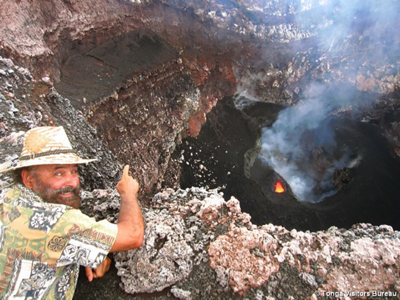 |
Figure 6. Looking into the active crater at Tofua on 24 April 2010 from the crater's N side. The shot emphasizes the crater's sheer walls, ledges draped with ash, and a morphologically complex crater floor covered by black, fresh looking spatter, ash, and possibly lava flows. The scene on the crater floor differs somewhat from the photo made in March 2009 (BGVN 34:02). A large down-dropped zone seems to have developed adjacent (to the right of) the glowing vent. Portions of that lower area emitted gases. As in the 2009 photo, this documents a glowing vent that contains molten lava and the area at the far end of this vent suggest active spattering. Photo by Stuart Kershaw posted by the Tonga Visitors Bureau. |
Other photos confirmed that, seen from a distance, the active Lofia crater emitted either a substantial white plume or thin gaseous emissions. A down-dropped zone appears to have developed on part of the crater floor between March 2009 and early 2010 (figure 6). The floor itself is not horizontal; much of it slopes at ~45 degrees from the horizontal.
The original caption for the photo shown in figure 6 read "Mark Belvedere peers into Tofua's very active volcanic crater." Belvedere (president of the Kalia Foundation, an organization developed to preserve and extend the Polynesian seafaring tradition) participated in events associated with the re-enactment. The sailors traveled on a replica of the boat used by Bligh and the crew members loyal to him.
According to the expedition announcements, the re-enactment attempted to make the voyage under similar conditions with the same amount of food and water. The sailors went without charts, additional landfalls, and many modern luxuries. According to news accounts, the 2010 voyage took 7 weeks, ending in Kupang, West Timor.
VAAC report in 2011. July reports by the Tonga Meteorological Services and pilot observations described a cloud of unspecified color and dimension from Tofua that rose to an altitude of 1.3 km. This led the Wellington Volcanic Ash Advisory Centre (VAAC) to produce aviation reports (called Volcanic Ash Advisories) starting 13 July 2011. Follow-up reports (without new information) continued until 19 July 2011. Subsequent notices stated that the cloud was not detected in satellite imagery.
Bligh's comment. Following the 1789 mutiny on the Bounty, Captain William Bligh and 18 others were cast adrift on the small launch in which they completed a 6,700 km journey from near Tofua to West Timor. Bligh's small notebook formed the basis of In Bligh's Hand: Surviving the Mutiny on the Bounty (Gall, 2010). An entire chapter is devoted to Tofua ("We eat under great apprehension of the Natives, Tofua and indigenous relations") but the remarks describing the volcano's behavior are brief:
"When Bligh left the Bounty in the launch, he set course for Tofua, 30 miles away. Its location was marked by a smoke smudge on the skyline issuing from the island's active volcano."
That comment indicates the volcano was degassing when seen in 1789, but leaves the issue of the exact eruptive state ambiguous. The earliest witnessed eruption, the 1774 eruption seen by Captain Cook, was judged as explosive (a VEI 2 eruption; Siebert and others, 2010).
References. Gall, J., 2010, In Bligh's Hand: Surviving the Mutiny on the Bounty, National Library of Australia collection highlights, 234 pp. [ISBN: 9780642277053] (Selected portions, including those referred to here, available on Google books, URL: http://books.google.com/books?id=0TfjOmTv8bYC& )
Siebert, L., Simkin, T., and Kimberly, P., 2010, Volcanoes of the World, 3nd edition: University of California Press and Smithsonian Institution, 568 p.
Tonga Visitors Bureau, 2010, The 'Mutiny on the Bounty' crew visit the volcanic island of Tofua; Tonga Visitors Bureau (Ministry of Tourism), the National Tourist Office (NTO) for the Kingdom of Tonga, URL: http://www.tongaholiday.com/?p=4892; Posted 6 May 2010; accessed August 2011.
Geological Summary. The low, forested Tofua Island in the central part of the Tonga Islands group is the emergent summit of a large stratovolcano that was seen in eruption by Captain Cook in 1774. The summit contains a 5-km-wide caldera whose walls drop steeply about 500 m. Three post-caldera cones were constructed at the northern end of a cold fresh-water caldera lake, whose surface lies only 30 m above sea level. The easternmost cone has three craters and produced young basaltic andesite lava flows, some of which traveled into the caldera lake. The largest and northernmost of the cones, Lofia, has a steep-sided crater that is 70 m wide and 120 m deep and has been the source of historical eruptions, first reported in the 18th century. The fumarolically active crater of Lofia has a flat floor formed by a ponded lava flow.
Information Contacts: Hawai'i Institute of Geophysics and Planetology (HIGP) MODVOLC Thermal Alerts System, School of Ocean and Earth Science and Technology (SOEST), Univ. of Hawai'i, 2525 Correa Road, Honolulu, HI 96822, USA (URL: http://modis.higp.hawaii.edu/); Kalia Foundation USA, 4515 SW Natchez Ct., Tualatin, Oregon 97062 USA; Mark Belvedere, Treasure Island Eueiki Eco Resort, Vava'u, Tonga; Stuart Kershaw, In the Dark Productions company (URL: http://inthedarkproductions.co.uk/); Wellington Volcanic Ash Advisory Center (VAAC), New Zealand (URL: http://vaac.metservice.com/).