Report on Ebeko (Russia) — July 2011
Bulletin of the Global Volcanism Network, vol. 36, no. 7 (July 2011)
Managing Editor: Richard Wunderman.
Ebeko (Russia) Gas-and-steam plumes and ash plumes in 2009 and 2010
Please cite this report as:
Global Volcanism Program, 2011. Report on Ebeko (Russia) (Wunderman, R., ed.). Bulletin of the Global Volcanism Network, 36:7. Smithsonian Institution. https://doi.org/10.5479/si.GVP.BGVN201107-290380
Ebeko
Russia
50.686°N, 156.014°E; summit elev. 1103 m
All times are local (unless otherwise noted)
Our most recent report on Ebeko (BGVN 34:08) described intermittent activity from mid-2005 to mid-2009, primarily plumes that sometimes deposited minor ash. Ebeko lacks a dedicated seismometer; therefore, the Kamchatkan Volcanic Eruption Response Team (KVERT) generally monitors the volcano with visual and satellite observations (figure 4). Intermittent plumes continued in 2009-2010.
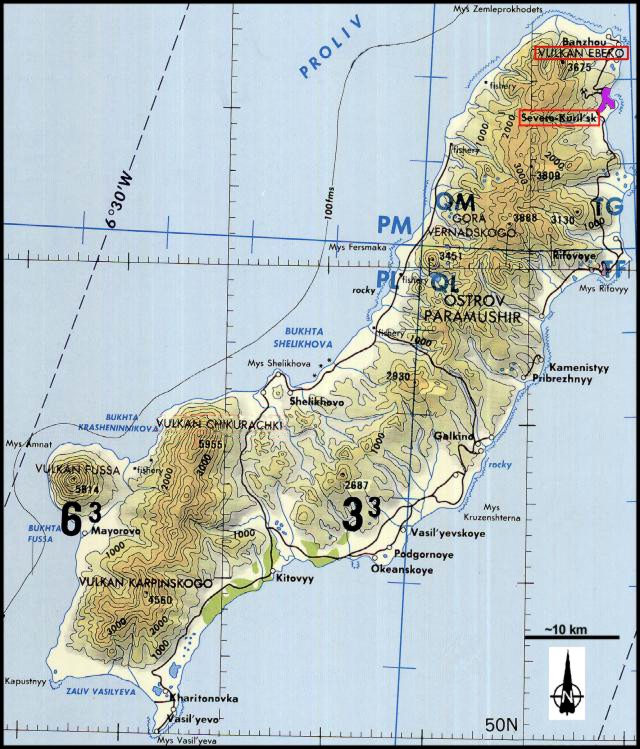 |
Figure 4. Topographic map of Paramushir Island (Ebeko volcano sits at the extreme NE end and town of Severo-Kurilsk is nearby). From National Oceanic and Atmospheric Administration Tactical Pilotage Chart ONC-E10C, as provided by McGimsey and others (2005). |
Activity during October 2009. Based on analyses of satellite imagery, the Tokyo VAAC reported two possible eruption plumes from Ebeko in October 2009. The first plume, reported on 15 October 2009, rose to an altitude of 10.7 km and drifted NE. The second plume, on 26 October, rose to an altitude of 8.8 km and drifted E.
KVERT reported that on 26 October a gas-and-steam plume was seen by observers in Severo-Kurilsk (figure 4), a town about 7 km E of Ebeko. The plume rose about 300 m above the crater and drifted 1-2 km NNE. Gas-and-steam plumes rose 250 m above the crater and drifted 2 km E on 28 October and NNE on 29 October 2009.
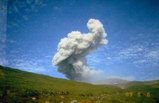
Activity during June-July 2010. KVERT reported that activity increased on 2 July according to observers in Severo-Kurilsk (figure 5). Explosions produced ash plumes that rose to an altitude of 1.8 km and drifted SSE. The Aviation Color Code was raised to Yellow. On 23 July, KVERT reported that the Aviation Color Code was lowered to Green. Visual observations and satellite data indicated no activity from the volcano during 16-23 July.
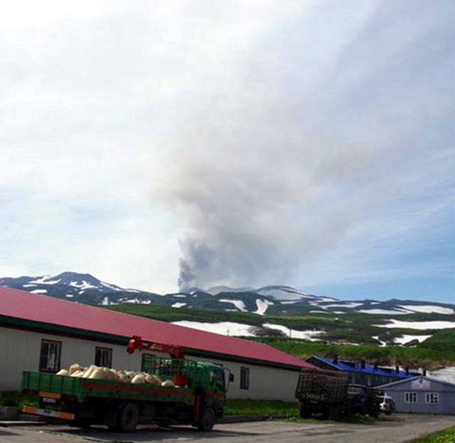 |
Figure 5. Photograph of an ash explosion from Ebeko on 2 July 2010 taken from the town of Severo-Kurilsk. Photo taken by Leonid Kotenko. |
Geological Summary. The flat-topped summit of the central cone of Ebeko volcano, one of the most active in the Kuril Islands, occupies the northern end of Paramushir Island. Three summit craters located along a SSW-NNE line form Ebeko volcano proper, at the northern end of a complex of five volcanic cones. Blocky lava flows extend west from Ebeko and SE from the neighboring Nezametnyi cone. The eastern part of the southern crater contains strong solfataras and a large boiling spring. The central crater is filled by a lake about 20 m deep whose shores are lined with steaming solfataras; the northern crater lies across a narrow, low barrier from the central crater and contains a small, cold crescentic lake. Historical activity, recorded since the late-18th century, has been restricted to small-to-moderate explosive eruptions from the summit craters. Intense fumarolic activity occurs in the summit craters, on the outer flanks of the cone, and in lateral explosion craters.
Information Contacts: Kamchatka Volcanic Eruptions Response Team (KVERT), Far East Division, Russian Academy of Sciences, 9 Piip Blvd., Petropavlovsk-Kamchatsky, 683006, Russia (URL: http://www.kscnet.ru/ivs/); Tokyo Volcanic Ash Advisory Center (VAAC), Tokyo, Japan (URL: http://ds.data.jma.go.jp/svd/vaac/data/).