Report on Tofua (Tonga) — September 2011
Bulletin of the Global Volcanism Network, vol. 36, no. 9 (September 2011)
Managing Editor: Richard Wunderman.
Tofua (Tonga) Elaborative comments on April 2010 observations
Please cite this report as:
Global Volcanism Program, 2011. Report on Tofua (Tonga) (Wunderman, R., ed.). Bulletin of the Global Volcanism Network, 36:9. Smithsonian Institution. https://doi.org/10.5479/si.GVP.BGVN201109-243060
Tofua
Tonga
19.75°S, 175.07°W; summit elev. 515 m
All times are local (unless otherwise noted)
This report on Tofua elaborates on observations in our previous report (BGVN 36:07).
Several maps show Tofua (figure 7) with respect to other geographic features, and also areas of responsibility of Volcanic Ash Advisory Centers in the region. A map of islands in the main part of the Archipelago appeared in BGVN 34:02.
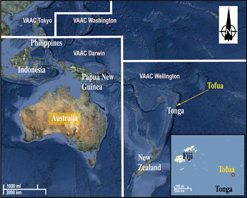 |
Figure 7. (inset at lower right) Tofua shown in geographic context. Tofua is a part of the Kingdom of Tonga. (main map) Various areas of responsibility of Volcanic Ash Advisory Centers (VAACs) in the region; responsibility for Tonga resides with the Wellington Volcanic Ash Advisory Centre. Courtesy of ESRI Corporation (modified). |
Mark Belvedere (Kalia Foundation) sent additional comments regarding his visit to Tofua on 24 April 2010 (see BGVN 36:07). Belvedere noted that at night as they approached the island the glow from the active crater flickered and was visible ~50 km from the volcano. The glow was absent during the day but a plume was conspicuous. In describing his approach to the crater he stated that "As I was walking up towards [it] the area was littered with lava stone from the sizes of golf balls to beach balls." The observation of those ejecta made him nervous. To him, the crater "looked like an air-breathing red hot lava tube ready to shoot out lava stones at any moment but NO I didn't stay to physically see it shooting out the lava nor the lava stones."
Upon reaching the summit the visitors were surprised at how unstable the rim looked. Belvedere had to have his companions hold his feet in order to lean out over the crater to get the photo shown in our previous report (BGVN 36:07). He guessed the distance to the sloping crater floor was on the order of 50 m. The low-level eruptions accompanied larger ash plumes. The plumes were quite reflective at night. A sulfurous odor prevailed.
Stuart Kershaw's attempts to create a video with narration on the scene proved difficult because the eruptions were broken with pauses of about 8-15 minutes, and each pulse behaved differently in terms of how much sound they generated.
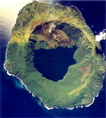
Geological Summary. The low, forested Tofua Island in the central part of the Tonga Islands group is the emergent summit of a large stratovolcano that was seen in eruption by Captain Cook in 1774. The summit contains a 5-km-wide caldera whose walls drop steeply about 500 m. Three post-caldera cones were constructed at the northern end of a cold fresh-water caldera lake, whose surface lies only 30 m above sea level. The easternmost cone has three craters and produced young basaltic andesite lava flows, some of which traveled into the caldera lake. The largest and northernmost of the cones, Lofia, has a steep-sided crater that is 70 m wide and 120 m deep and has been the source of historical eruptions, first reported in the 18th century. The fumarolically active crater of Lofia has a flat floor formed by a ponded lava flow.
Information Contacts: Mark Belvedere, Kalia Foundation USA, 4515 SW Natchez Ct., Tualatin, OR 97062, USA (www.kaliafoundation.org); Treasure Island Eueiki Eco Resort, Vava'u, Kingdom of Tonga (www.tongaislandresort.com); Stuart Kershaw, In the Dark Productions (URL: http://inthedarkproductions.co.uk/); Sakopo Lolohea, Tongan Visitor Bureau, Ministry of Tourism. Vuna Rd., Nuku'alofa, Tonga (URL: http://www.tonga.holiday.com/).