Report on Additional Reports (Unknown) — November 2011

Bulletin of the Global Volcanism Network, vol. 36, no. 11 (November 2011)
Managing Editor: Richard Wunderman.
Additional Reports (Unknown) Tonga: Material of uncertain origin seen on 13 April 2011
Please cite this report as:
Global Volcanism Program, 2011. Report on Additional Reports (Unknown) (Wunderman, R., ed.). Bulletin of the Global Volcanism Network, 36:11. Smithsonian Institution. https://doi.org/10.5479/si.GVP.BGVN201111-600500
Additional Reports
Unknown
Lat Unknown, Unknown; summit elev. m
All times are local (unless otherwise noted)
Based on inspection of a photo taken on 13 April 2011 from the International Space Station of Tofua volcano (Tonga), it appeared that possible pumice rafts were floating near the island (BGVN 36:09). However, the source of the material was unknown.
The source, extent, and makeup of the material remains uncertain. Inquiries sent to Mark Belvedere and others in Tonga in late 2011 failed to identify any mariners or other observers who recall seeing either an eruption or material floating on the sea surface around March to April 2011.
If the rafts drifted from the Tongan region, as they have often done in the past, they may have originated from an eruption at one of the volcanoes of the Ha'apai and Vava'u Groups. Some of those, such as Late, Home Reef, Metis Shoal, and Falcon Island, have erupted frequently, with pumice rafts and emergent ephemeral islands (figure 2).
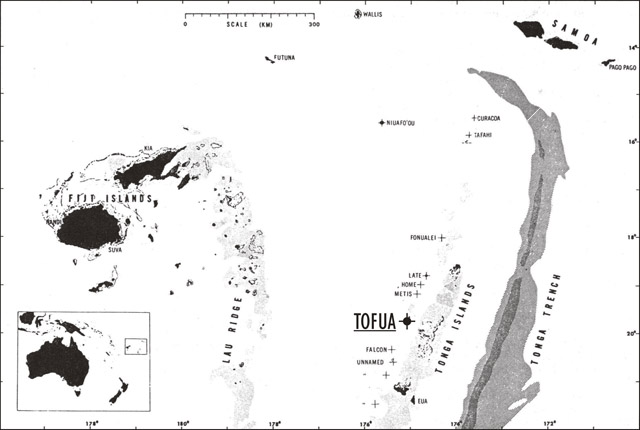 |
Figure 2. Map of the Tonga-Samoa area showing Tofua. Historically active volcanic centers are indicated by crosses. Stippled areas delineate water less than 1 km deep; diagonal and cross-ruled patterns indicate trench areas greater than 6 and 8 km, respectively. After Anonymous, 1979, with map credit to Tom Simkin (GVP). |
Figure 2 came from a similar report in 1979, but in that (very different) case the initial problem was four active eruptive sources, any of which might explain the streaks and rafts of floating pumice drifting NE. The resulting uncertainty then revolved around which of those sources produced the bulk of the floating pumice (SEAN 04:06; Anonymous, 1979). Discovery of a large ephemeral island at Metis Shoal pointed to that as the primary source of the pumice rafts (SEAN 04:07 and 04:12).
NASA initiative and findings. Childs and others (2011), Chojnacki and others (2011), and Honaker and Childs (2011) point out the very practical goal of a "more timely warning system to divert maritime vessels from affected areas." They discussed the spectral signature of several pumice rafts from a remote-sensing perspective. They assessed the date of eruption onset, the volcano's name, coordinates, and the favored satellites to detect and track these rafts in their different environments.
For the limited cases they tested, MODIS best detected large scale pumice rafts and monitored them over time. Landsat 5, 7 and ALI best detected small rafts, especially in closed bodies of water such as lakes. The false-color composite improved the contrast of pumice rafts for visual identification. Thermal anomalies occurred over several large pumice rafts. They found a subpixel classification extremely effective at automatically identifying small areas of pumice.
Note that, for the case at hand, the authors did not know of or analyze the material on the sea surface.
References. Anonymous, 1979, Geophysical Events: Eos, Transactions, American Geophys. Union, 21 Aug 1079, p. 625.
Childs, LM, Chojnacki, PR, Coady, C., Geddes, Q, Honaker, LB, Lyddane, W, McGilloway, J, Scott, J, 2011, Pacific Ocean Disasters - Enhanced Detection and Monitoring of Pumice Rafts Using NASA EOS; Eos, Transaction of the Am. Geophys. Union, V44C-04; (URL: http://www.agu.org/meetings/)
Chojnacki, P, Lyddane, W, McGilloway, J, Geddes, Q, Honaker, L, Coady, C, and Scott, J, 2011, Implementing NASA Remote Sensing to Protect and Monitor our Waterways, [ley DEVELOP Team 5, posted 10 August 2011 in DEVELOP Virtual Poster Session with written transcript] Earthzine (URL: http://www.earthzine.org/2011/08/10/implementing-nasa-remote-sensing-to-protect-and-monitor-our-waterways/, https://www.youtube.com/watch?feature=player_embedded&v=sdTZFq8Kpg4).
Honaker, LB, Childs, L, 2011, Remote Sensing Monitoring of Pumice Rafts in the Pacific Ocean (URL: http://www.nianet.org/NIA/media/photo-gallery/Remote-Sensing-Monitoring-of-Pumice-Rafts-in-the-Pacific-Ocean.pdf).
Geological Summary. Reports of floating pumice from an unknown source, hydroacoustic signals, or possible eruption plumes seen in satellite imagery.
Information Contacts: Mark Belvedere, Treasure Island Eueiki Eco Resort, Vava'u, Tonga.