Report on Galunggung (Indonesia) — April 2012
Bulletin of the Global Volcanism Network, vol. 37, no. 4 (April 2012)
Managing Editor: Richard Wunderman.
Galunggung (Indonesia) One possible 2008 ash plume, crater lake anomalies in 2011-2012
Please cite this report as:
Global Volcanism Program, 2012. Report on Galunggung (Indonesia) (Wunderman, R., ed.). Bulletin of the Global Volcanism Network, 37:4. Smithsonian Institution. https://doi.org/10.5479/si.GVP.BGVN201204-263140
Galunggung
Indonesia
7.25°S, 108.058°E; summit elev. 2168 m
All times are local (unless otherwise noted)
This report mentions a possible ash plume from Galunggung volcano in July 2008 and various other anomalies, including discolored crater lake water during parts of 2011 and 2012. Our last report on Galunggung was in 1984 (SEAN 09:02), following a deadly eruption that began in mid-1982 and ended in early 1983.
The following background information on the volcano was provided in 13 February and 28 May 2012 reports from the Indonesian Center of Volcanology and Geological Hazard Mitigation (CVGHM). According to the latest report from CVGHM, the present-day lake in the conical crater of Galunggung volcano has a diameter of 1 km and a typical depth of 11 m. In the middle of the lake sits a small, 30 m high, 250 x 165 m scoria cone which was produced during the final stage of the 1982-83 eruption. Galunggung's hazards include phreatic and phreatomagmatic eruptions capable of draining the lake and producing mud flows.
As further background, some of the historical eruptions were explosive, centered at the volcano's crater lake. These eruptions occurred four times, in 1822, 1894, 1918, and 1982-1983. The eruption of 1982-1983 occurred over a period of 21 months, from 5 April 1982-8 January 1984 (SEAN 07:04, 07:06, 07:07, 07:08, 07:09, 07:10, 07:11, and 07:12). In late June 1982, a British Airways jumbo jet encountered an ash cloud that stalled all four of its engines and abraded its windshield and wing surfaces. The aircraft lost 7.5 km of altitude before the engines could be restarted, but it landed safely in Jakarta (SEAN 07:06).
Incorrect report of 2002 eruption; questionable one in 2008. Based on erroneous information from a pilot report, the Darwin Volcanic Ash Advisory Centre (VAAC) stated that an eruption occurred at Galunggung at 1748 hr on 23 August 2002. It produced a W-drifting low-level plume. No ash was visible on satellite imagery. Subsequently, Dali Ahmad of CVGHM had advised Dan Shackelford (amateur volcanist, now deceased) that the report of an eruption on 23 August 2002 was incorrect. It turned out that the likely cause of the incident was a bushfire near the volcano that led observers to believe that an eruption was occurring.
Based on a pilot report and inconclusive observations of satellite imagery, the Darwin VAAC reported that on 17 July 2008 a possible ash plume from Galunggung rose to an altitude of 5.5 km and drifted SW. However, CVGHM did not report eruptive activity and advised that the volcanic activity status was "normal" at that time.
2011-2012 observations. CVGHM reported that from September 2011 to 8 February 2012 the crater lake water at Galunggung was discolored. In addition, a sudden increase in water temperature was measured, from 27° C on 5 February to 40° C on 8 February. Based on seismic data and crater lake observations, CVGHM raised the Alert Level from 1 to 2 (on a scale of 1-4) on 12 February and recommended that people stay at least 500 m away from the lake shore.
CVGHM reported that after the Alert Level was raised, seismic activity at Galunggung decreased drastically through 27 May 2012. Moreover, on 27 April, plants around the crater area looked green and lush, small fish were swimming in the water, and insects around the crater were active. Based on seismic data, crater lake water temperature and pH data, and visual observations, CVGHM lowered the Alert Level from 2 to 1 on 28 May 2012.
MODVOLC satellite thermal alerts were absent at Galunggung during 2011-2012 (and at least since 2000). CVCHM noted in its 28 May 2012 report that throughout the first half of 2012 Galunggung volcano was often covered in mist.
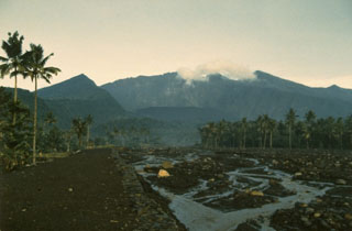
Geological Summary. The forested slopes of Galunggung in western Java SE of Bandung are cut by a 2-km-wide collapse scarp open towards the ESE. The "Ten Thousand Hills of Tasikmalaya" dotting the plain below the volcano are debris-avalanche hummocks from the collapse about 4,200 years ago. An eruption in 1822 produced pyroclastic flows and lahars that killed over 4,000 people. A series of major explosive eruptions starting in April 1982 destroyed a number of villages, killed as many as 30 people, and forced over 60,000 to evacuate. Pyroclastic flows and heavy widespread ash caused significant damage. A large passenger jet that encountered the ash plume on 24 June lost power to all four engines but managed to land safely in Jakarta. The 1982 activity destroyed a 1918 dome and formed the Warirang crater, almost as wide as the valley, about 2 km down from the summit.
Information Contacts: Center of Volcanology and Geological Hazard Mitigation (CVGHM) (URL: http://www.vsi.esdm.go.id); Darwin Volcanic Ash Advisory Centre (VAAC) (URL: http://www.noaa.gov/VAAC/OTH/AU/messages.html).