Report on Tokachidake (Japan) — October 2012
Bulletin of the Global Volcanism Network, vol. 37, no. 10 (October 2012)
Managing Editor: Richard Wunderman.
Tokachidake (Japan) Small hot gas emissions and minor seismicity in mid-2012
Please cite this report as:
Global Volcanism Program, 2012. Report on Tokachidake (Japan) (Wunderman, R., ed.). Bulletin of the Global Volcanism Network, 37:10. Smithsonian Institution. https://doi.org/10.5479/si.GVP.BGVN201210-285050
Tokachidake
Japan
43.418°N, 142.686°E; summit elev. 2077 m
All times are local (unless otherwise noted)
During 1995-1996, Tokachi (also called Tokachi-dake) intermittently experienced increased seismicity (BGVN 20:07, 20:08, 20:11/12, and 21:05). The volcano is located in central Hokkaido, the northernmost of Japan's 47 prefectures (figure 6).
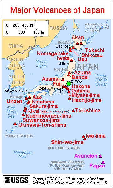 |
Figure 6. A map showing the major volcanoes of Japan; Tokachi is in the upper right. Courtesy of the U.S. Geological Survey. |
Monthly reports of volcanic activity from the Japan Meteorological Agency (JMA) translated into English resumed in October 2010. The only recent English-translated JMA report on Tokachi appeared in June 2012. The only other account available on this volcano between 1996 and June 2012 was in 2003, when a news account (Associated Press) mentioned that volcanic tremor occurred on 8 February 2003 and lasted for 37 minutes. This news account noted that the JMA saw no emissions or other signs that an eruption had occurred.
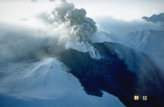
According to JMA, a small event in Taisho crater occurred, apparently on 1 June 2012. Hot gas from this event flowed down the NE and E flanks of Tokachi. Aerial observations on 1 June 2012 with an infrared camera revealed high temperature areas on the E wall of Taisho crater. No ejecta such as volcanic ash was observed around the crater. A field study that same day measured the average sulfur dioxide flux as 600 metric tons/day (t/d). After 4 June, the crater's temperature and gas emission volume decreased.
According to JMA, on 30 June 2012 volcanic glow in the Taisho crater was observed with a high-sensitivity camera. This glow gradually brightened toward the early morning of 1 July and continued through the early morning of 5 July. Thereafter, the glow diminished, suggesting a decreasing temperature. JMA believed the glow stemmed from the emission of high-temperature volcanic gases and the burning of sulfur. No changes occurred with respect to volcanic earthquakes, tremor, ground deformation, and infrasonic data either before or after the period of volcanic glow.
On 1 July, infrared camera observations again revealed high-temperature areas on the E wall of Taisho crater. These high temperatures persisted through most of July, after which they returned to normal. Several reports in July noted a small new fumarole near an existing fumarole on the E wall of the crater. Scientists conducting a field survey on 1 July measured the flux of sulfur dioxide from the fumarole at 600 t/d. No field surveys were conducted after 3 July because of bad weather, but officials believed that SO2 levels had decreased, given that emissions from the fumarole had decreased.
On 11 July, instruments recorded small-amplitude, short-duration volcanic tremor. This was followed by small-amplitude volcanic earthquakes until the next morning. These events were not accompanied by any change in fumarole emissions, infrasonic data, or ground-deformation data. The hypocenters were located just beneath the shallow part of the Ground Crater (in Japanese, Guraundo-kako; translates into English as "old crater").
In July, GPS ground deformation data at Mae-Tokachi-Dake, a stratovolcano cone of Tokachi, found a small area of inflation at the shallow part of a crater designated as 62-2.
Geological Summary. Tokachidake volcano consists of a group of dominantly andesitic stratovolcanoes and lava domes arranged on a NE-SW line above a plateau of welded Pleistocene tuffs in central Hokkaido. Numerous explosion craters and cinder cones are located on the upper flanks of the small stratovolcanoes, with the youngest Holocene centers located at the NW end of the chain. Frequent historical eruptions, consisting mostly of mild-to-moderate phreatic explosions, have been recorded since the mid-19th century. Two larger eruptions occurred in 1926 and 1962. Partial cone collapse of the western flank during the 1926 eruption produced a disastrous debris avalanche and mudflow.
Information Contacts: Japan Meteorological Agency (JMA), Otemachi, 1-3-4, Chiyoda-ku Tokyo 100-8122, Japan (URL: http://www.jma.go.jp/); Associated Press (URL: https://www.ap.org/).