Report on Nevado del Huila (Colombia) — October 2012

Bulletin of the Global Volcanism Network, vol. 37, no. 10 (October 2012)
Managing Editor: Richard Wunderman.
Edited by Julie A. Herrick.
Nevado del Huila (Colombia) 10 lives lost, houses and infrastructure destroyed during November 2008 eruption
Please cite this report as:
Global Volcanism Program, 2012. Report on Nevado del Huila (Colombia) (Herrick, J.A., and Wunderman, R., eds.). Bulletin of the Global Volcanism Network, 37:10. Smithsonian Institution. https://doi.org/10.5479/si.GVP.BGVN201210-351050
Nevado del Huila
Colombia
2.93°N, 76.03°W; summit elev. 5364 m
All times are local (unless otherwise noted)
Eruptions at Nevado del Huila during February and April 2007 included substantial ash plumes, lahars, earthquake swarms (with individual earthquakes up to M ~3), and the growth of fissures, crevasses, and new fumaroles on the upper, glacier-covered flanks (BGVN 33:01). After the explosive eruption on 18 April 2007, the Instituto Colombiano de Geología y Minería (INGEOMINAS) reported decreasing seismicity and activity through December 2007 (figure 13). After that, sporadic peaks in seismicity occurred in 2008 and, after a significant increase in long period (LP) earthquakes in November 2008, a large eruption and devastating lahars occurred on 20 November 2008. In this report, we discuss hazard mitigation efforts, escalating SO2 emissions, and unrest that culminated in that fatal November 2008 eruption.
INGEOMINAS activity bulletins and documentation of humanitarian efforts in this report were initially synthesized and edited by Jamie Kern, as part of a graduate student writing assignment in a volcanology class at Oregon State University under the guidance of professor Shan de Silva.
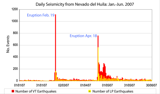 |
Figure 13. In this histogram of daily seismicity for 2007, the two major peaks represent elevated seismicity during Nevado del Huila's February and April 2007 eruptions. Courtesy of INGEOMINAS. |
Two volcanic hazard maps. The INGEOMINAS map of potential volcanic hazards for Nevado del Huila focuses on both the immediate area around the volcanic complex and the extensive drainages in the region (figures 14 and 15), which are differing ways to depict the same hazard information.
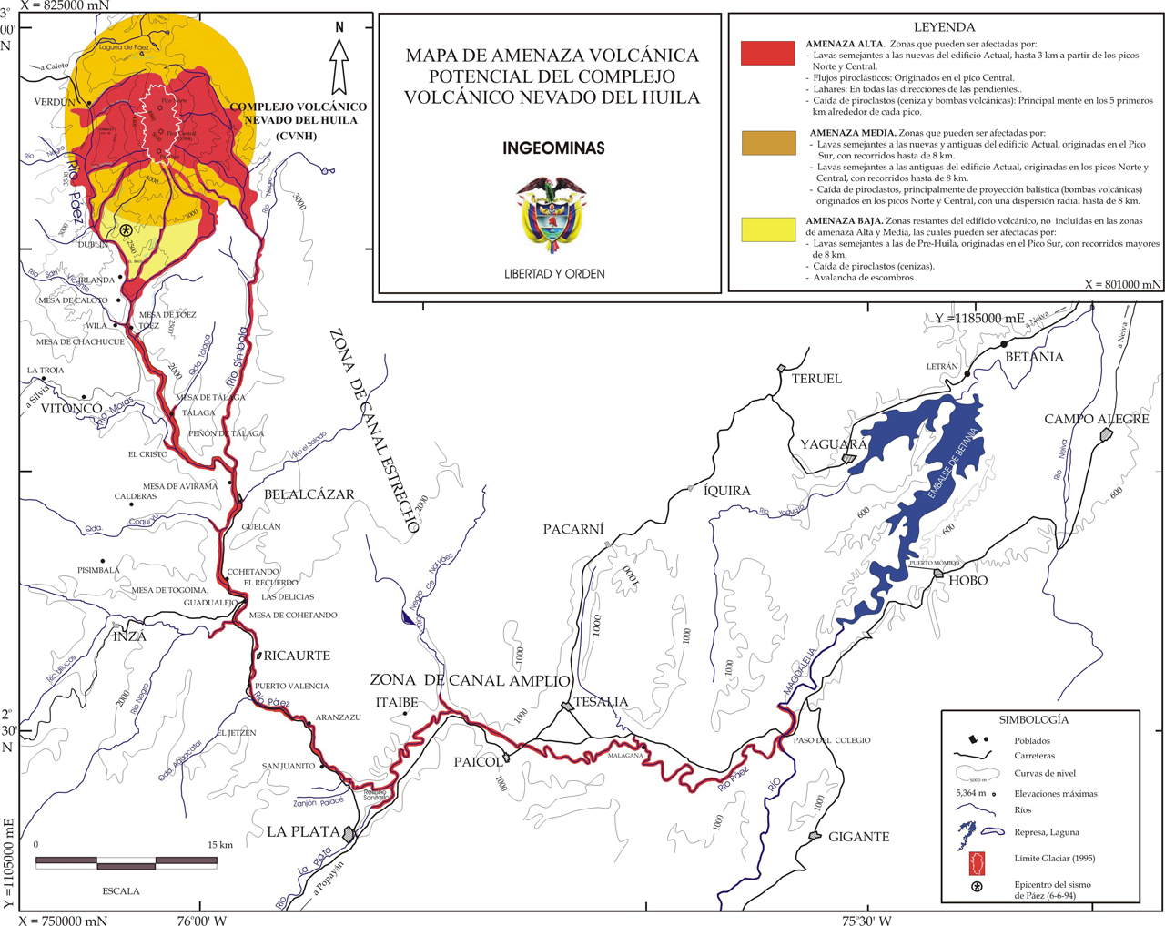 |
Figure 14. This volcanic hazard map of Nevado del Huila was prepared by INGEOMINAS in 1996. Hazard zonation defines three areas at risk: Highest risk (red), Moderate risk (orange), and Low risk (yellow). The Spanish text in "Leyenda" corresponds to descriptions of hazards translated in the accompanying text. Courtesy of INGEOMINAS. |
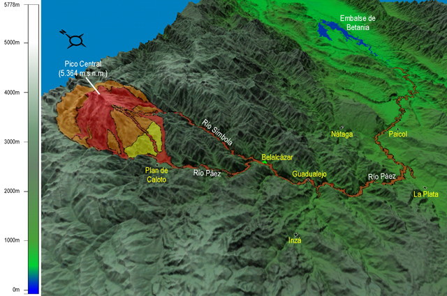 |
Figure 15. This 3D map combines the hazard zones of Nevado del Huila with a digital elevation model (DEM) of the region. Major rivers and towns are labeled including Belalcázar, in the Río Páez channel. For scale, the linear distance between Belalcázar and Guadualejo is ~20 km. Courtesy of INGEOMINAS. |
In figures 14 and 15, the red zone (highest risk) includes the young volcanic edifice and the major drainages; this region may experience lava flows up to 3 km from the edifice, particularly from the N and central peaks (see figure 6 in BGVN 33:01 for an annotated photo of peaks and names); pyroclastic flows are possible from the central peak (Pico Central); lahars could occur along the flanks and connected drainages; ash and volcanic bombs may fall to distances of 5 km from the volcanic peaks. Volcanic seismicity and gases are also a hazard in the most proximal regions. Note the high risk area extends more than 100 km along the length of the major drainage system (reaching the junction with Río Magdalena).
The orange zone (moderate risk) extends beyond the immediate volcanic edifice and encompasses an approximately circular region within a radius of 8 km. Within this zone, lava flows could cover the young and old edifice originating from Pico Sur (S peak) reaching distances up to 5 km; lava flows from the N and central peaks may cover the old edifice; pyroclastics, particularly lava bombs, could reach this region and fall up to 8 km from the N and central peaks. Seismicity and hazardous volcanic gases could also occur in the orange zone, but these events have a lower probability here compared to similar events in the red zone.
The yellow zone (lowest risk) is confined to the S flank within the Río Páez drainage system. This area was distinguished from the other regions due to the potential for debris avalanches, pyroclastic fall (mainly ash), and lava flows that could cover the pre-Huila edifice originating from Pico Sur and extending ~8 km down slope. Pyroclastic flows are also possible in the case of dome or lava flow front collapse.
Post-eruptive activity, May-December 2007. After the main eruption on 18 April 2007 and small ash emissions on 14 and 27 May 2007, INGEOMINAS reported that Nevado del Huila entered a period of relative quiescence (BGVN 33:01).
In late April, SO2 emissions remained high. OMI and mobile DOAS instruments detected SO2 emissions of greater than 13,000 tons per day between 24 and 28 April (table 1). Mobile DOAS data was also available during 1-2 June. Values in the range of 3,000-6,900 tons per day (t/d) were obtained from overflights and land-based traverses beneath the plume (BGVN 33:01).
Table 1. Between 2 March 2007 and 1 May 2007, INGEOMINAS reported seven analyses of SO2 flux from the OMI/Aura satellite. Courtesy of INGEOMINAS, Simon Carn (Michigan Technological University), and the Joint Center for Earth Systems Technology (University of Maryland Baltimore County).
| Date | SO2 concentration-pathlength (for total metric tons atmospheric column) | Areal extent of SO2 (km2) | Maximum Altitude (km above summit) |
| 20 Feb 2007 | 2,500 | 154,265 | 3.67 |
| 21 Feb 2007 | ~1,000 | 270,273 | 5.11 |
| 02 Mar 2007 | 1,000-1,500 | -- | ~1.4 |
| 24 Apr 2007 | 1,555 | 51,767 | 3.71 |
| 26 Apr 2007 | 1,365 | 30,853 | 5.85 |
| 28 Apr 2007 | 1,444 | 51,262 | 3.61 |
| 01 May 2007 | 594 | 24,446 | 2.21 |
After seismic activity peaked during 19-30 April with more than 2,800 volcano-tectonic (VT) events detected, 1,331 VT events were detected in May. Four tremor events during that month were linked to small ash eruptions, the strongest occurred at 1010 UTC on 14 May and 0524 UTC on 21 May.
Seismicity decreased from over 300 events per week in June 2007 to fewer than 100 events per week in December 2007. Shallow and deep earthquakes were recorded during this time period, mostly M 2 or less. Earthquakes were generally clustered in three groups; the shallowest events were those that occurred within less than 3 km below the surface, those that occurred at depths of 4-8 km below the surface, and the deepest events, which occurred at depths between 15-25 km. Small ash explosions may have occurred during tremor events in July and one event in August. The appearance of tremor in local seismic records is often part of the criteria that INGEOMINAS considers when interpreting ash emissions from Nevado del Huila.
During a 19 August observation flight conducted by INGEOMINAS, scientists observed no changes in the dimensions of the fractures or the fumarolic activity since the April eruptions (figure 16). Observers saw a white column of gas that rose up to 100 m above the crater.
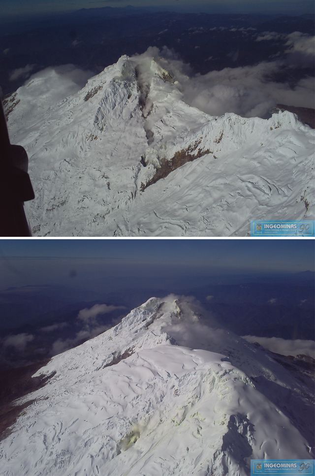 |
Figure 16. During an overflight of Nevado del Huila on 19 August 2007, views of Pico Central and Pico Norte showed the effects of unrest from earlier in the year, however, no additional changes were apparent. Details follow. (Top) One feature that had developed in February 2007 was a long, black fracture cutting down the N side of Pico Central. Yellow-colored snow and ice, described by INGEOMINAS as sulfur deposits, were visible near the top of Pico Central; steam-and-gas emissions vented along the fissure's length. (Bottom) On 19 August 2007, INGEOMINAS observed discolored snow and ice around a fumarole located on the N flank of Pico Norte (pale yellow steaming zone in the foreground). This fumarole had been active in February and April 2007. The tall peak in the middle ground is Pico Central. Courtesy of INGEOMINAS. |
Activity during January-May 2008. In January 2008, INGEOMINAS reported five episodes of tremor attributed to small ash events. People aboard commercial flights passing over the volcano in early January reported new ash deposits on the W flank of Pico Central. Seismometers detected pulses of tremor (~19), VT earthquakes (~193), and long-period (LP) seismicity (~284).
In February, INGEOMINAS reported that seismicity had decreased slightly. Volcanic tremor was rare (~4 events) and ~131 VT and ~193 LP events were detected. On 8 and 12 February, traverses with a mobile DOAS measured SO2 fluxes of 1,371 and 612 t/d, respectively. On both days, the gas column was dispersing NW. INGEOMINAS scientists conducted these surveys along the Pan-American Highway between Calí and Popayán.
Seismicity increased in March. Four swarms of earthquakes were detected and INGEOMINAS reported 23 tremor events, 704 VT events, and 478 LP earthquakes. SO2 emissions were assessed on 25 March during a mobile DOAS survey yielding 655 t/d.
Based on elevated seismicity, INGEOMINAS announced on 29 March 2008 an increase in Alert Level from Yellow (III, "Changes in the behavior of volcanic activity") to Orange (II, "Probability of eruption in terms of days or weeks").
El Tiempo reported on 4 April 2008 that Colombian Red Cross volunteers in the town of Belalcázar (~28 km SSE) on the Páez River were on 24-hour alert. The Local Committee of Disaster Prevention ordered the municipal school closed and placed the hospital on maximum alert. Jorge Quintero, director of the Red Cross in Belalcázar, reported that the town was aware of the dangers of mudflows and evacuation routes were in place, but that there were few shelters in the town and little aid to help them prepare for an eruption.
During an observation flight on 5 April, no significant geomorphic changes were observed at Pico Central or Pico Norte; sulfur odors were reported near areas of the E flank. Authorities of the Department of Cauca gave evacuation orders for families living in the Páez river basin on Monday 7 April. Inhabitants in high-risk areas were told to move to shelters in larger cities such as Inzá (25 km SSW) and Belalcázar. Elevated seismicity continued; ~12 pulses of tremor, 140 VT, and 84 LP earthquakes were recorded during 2-8 April.
Based on weekly bulletins from INGEOMINAS, there had been no reports of ash emissions since 25 March. On 8 April, the Alert Level was decreased to Yellow (III). On 13 April, a seismic swarm lasting over 2 hours and an associated M 3.4 earthquake near Pico Central resulted in an increase of the Alert Level to Orange (II).
On 14 April, a swarm of earthquakes was detected and LP seismicity suggested ash emissions had occurred. At 2308, the Alert Level was raised to Red (I), indicating "imminent eruption or in course," although the darkness made it difficult to discern what activity was occurring. El Tiempo reported that 4,500 people evacuated in less than 20 minutes from high-risk areas. The following day, the Alert Level was lowered to Orange (II).
On 15 April, INGEOMINAS reported that a seismic swarm occurred; between 2300 on 14 April and 0300 on 15 April, ~300 earthquakes were detected. Three VT earthquakes were detected during 13-15 April with magnitudes between 3.0 and 3.7. A gas survey with a mobile DOAS system was conducted on 15 April; the gas plume was dispersing W from the summit with an average flux of 700 t/d. SO2 surveys were repeated between 16 and 19 April and INGEOMINAS reported fluxes with a maximum of 1,541 t/d and a minimum of 514 t/d (the gas column dispersed W and the traverse followed the Pan-American Highway).
An observation flight on 29 April revealed no significant changes due to volcanic activity, but some glacial material had shaken loose and formed small flows high on the volcano that did not reach any major rivers. April seismicity included 966 VT, 642 LP, and 65 tremor events (figure 17).
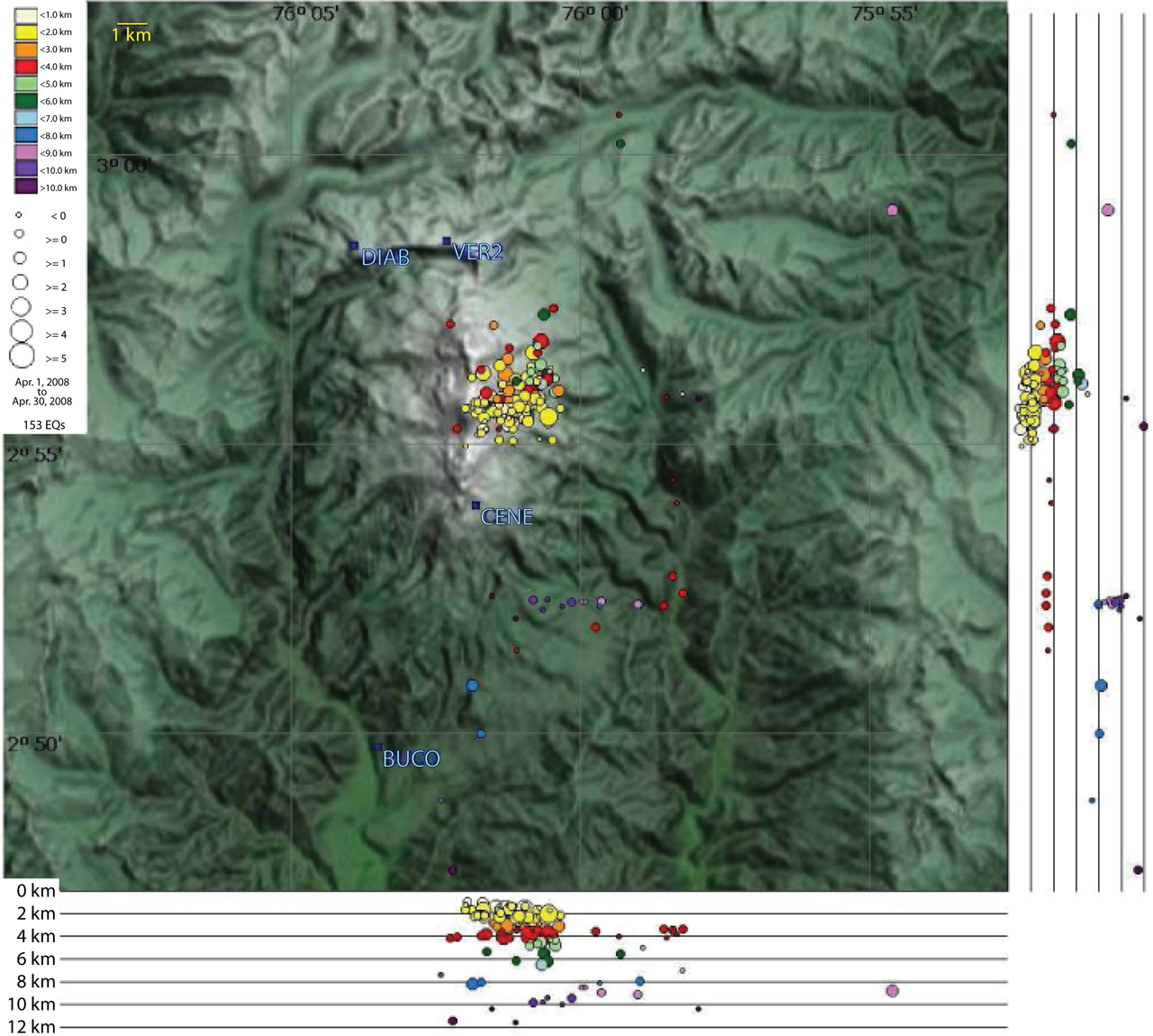 |
Figure 17. INGEOMINAS calculated 153 hypocenters for VT earthquakes at Nevado del Huila in April 2008. The shallowest events (1-3 km deep) clustered beneath the edifice in an area immediately ENE of Pico Central. This clustering of events was last observed in November 2007. Four seismic stations (VER2, DIAB, CENE, and BUCO) are labeled in blue text. Courtesy of INGEOMINAS. |
By early May, seismicity had decreased and the Alert Level was lowered to Yellow (III) on 6 May. On 9 May at 2316, 25 minutes of tremor occurred in an episode likely associated with ash emissions. This episode was preceded by 16 pulses of low-magnitude tremor. Sparse M 2-3 earthquakes were registered from Pico Central throughout the month and a swarm of 20 such events occurred on 27 May. The largest earthquake during this time, M 3.9, occurred at 2020. This event was felt by residents in the area of Plan de Caloto (2-7 km SW of Nevado del Huila) and had a relatively shallow depth, ~3 km below the summit of Pico Central. During 27-29 May LP earthquakes dominated the records.
Activity during June-August 2008. From June to August 2008, INGEOMINAS conducted gas surveys with a mobile DOAS system and recorded elevated SO2 emissions (figure 18). During this time period, the minimum flux was measured on 3 June (600 t/d) and the maximum flux was on 20 June (6,700 t/d). Sulfur dioxide odors were reported by scientists during an overflight of Nevado del Huila on 12 June 2008.
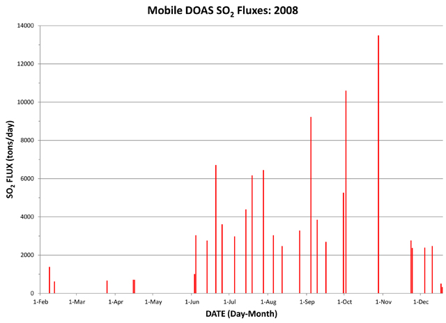 |
Figure 18. With a mobile DOAS unit, INGEOMINAS conducted gas surveys to determine SO2 flux from Nevado del Huila. Beginning in February 2008, SO2 emissions were relatively low until 13 June when 2,748 t/d was detected; SO2 emissions peaked on 28 October (13,482 t/d). The plume tended to disperse W and NW except in October when the plum drifted SW. Courtesy of INGEOMINAS. |
Seismicity during June-August 2008 included small episodes of VT and LP events, however, VT earthquakes dominated the record beginning in July (figure 19). An M 3.9 earthquake was felt by local residents on 11 June; this event occurred at 1503 local time and had a focal depth of 3 km below the summit of Pico Central. On 2 July at 1756, an M 2.7 VT earthquake occurred that was also detected by local populations in Plan de Caloto. This event was located 6.7 km S of Pico Central and had a focal depth of 2 km.
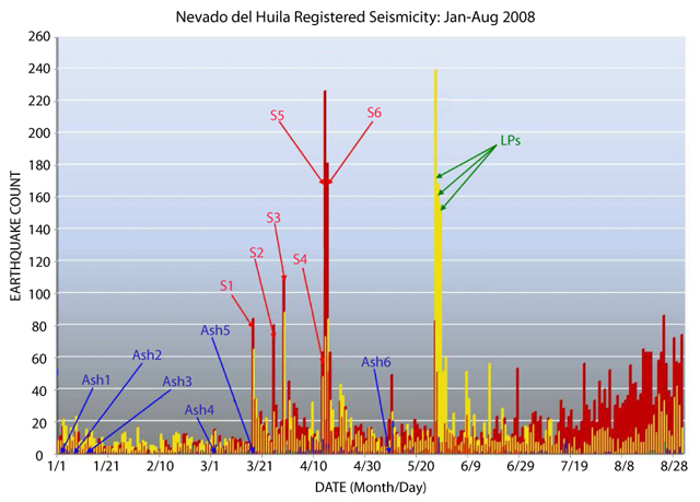 |
Figure 19. VT and LP seismicity from Nevado del Huila during January-August 2008 included numerous peaks that correlated with seismic swarms and ash emissions. Dates of highlighted events are as follows: Ash emissions, Ash1 = 2 January, Ash2 = 7 January, Ash3 = 12 January, Ash4 = 2 March, Ash5 = 17 March, Ash6 = 9 May; seismic swarms, S1 = 17 March, S2 = 25 March, S3 = 29 March, S4 = 13 April, S5 = 14 April, S6 = 15 April; and three episodes of LP earthquakes = 27-29 May. This plot was modified from a figure developed by INGEOMINAS. |
From June to August 2008, an average of 60 hybrid and 6 surficial events (rockfalls, avalanches, glacial noise, etc.) were detected per month. For the month of August 2008, seismometers detected 1,456 VT, 502 LP, 62 hybrid, 15 tremor, and 13 surficial events. Compared to April 2008, the distribution of earthquake hypocenters had become more dispersed over time. Thus, in August, earthquake focal depths were in the range of 0-13 km and were concentrated within linear groups (figure 20).
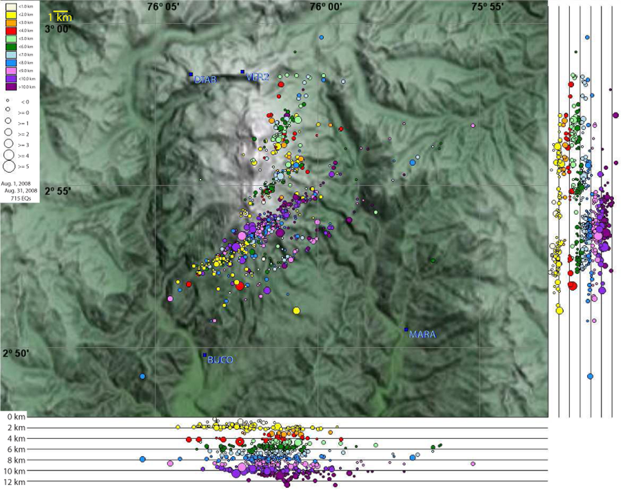 |
Figure 20. INGEOMINAS calculated 715 hypocenters for Huila's VT earthquakes in August 2008. Focal depths were in the range of 0-13 km below the edifice. Regardless of depth, these events were roughly aligned in diagonal groups. Four seismic stations (VER2, DIAB, MARA, and BUCO) are labeled in blue text. Courtesy of INGEOMINAS. |
Activity during September-October 2008. On 2 September 2008, an M 4.6 earthquake shook Pico Central, after which seismic activity steadily increased during the month. This earthquake was located 2.2 km NE of Pico Central and 1.7 km deep. Relatively large earthquakes were detected during 4-8 and 13-14 September. Four of the six largest earthquakes during 4-8 September caused local residents to report shaking. The largest event was an M 4, located 1 km N of Pico Central and at a depth of 3.5 km.
An M 4 earthquake that occurred at 1329 on 14 September was also noticed by residents; this event was 6.2 km SW of Pico Central with a focal depth of 7.3 km. VT seismicity continued to dominate the records in September and that month, the number of LP, tremor, and hybrid earthquakes increased compared to August (table 2).
Table 2. Seismicity detected at Nevado del Huila during August-December 2008. Courtesy of INGEOMINAS.
| Month | Volcano-tectonic | Long-period | Tremor | Hybrid | Surficial (eg. rockfalls) |
| Aug 2008 | 1,456 | 502 | 15 | 62 | 13 |
| Sep 2008 | 1,722 | 770 | 34 | 564 | 8 |
| Oct 2008 | 1,437 | 2,260 | 537 | 105 | 10 |
| Nov 2008 | 890 | 18,704 | 903 | 0 | 2 |
| Dec 2008 | 259 | 221 | 19 | 7 | 0 |
INGEOMINAS conducted four gas surveys in September and measured elevated SO2 emissions during traverses along the Pan-American Highway between Popayán and Calí, and also along the road between Corinto and Santander de Quilichao. The highest values were obtained on 4 September, when the SO2 flux was measured to be 9,215 t/d (figure 18).
During an observation flight in cooperation with the Colombian Air Force (FAC) on 12 September, observers noted intense fumarolic activity and small mudflows on the volcano's upper flanks. Seismicity was relatively high on 12 September and, at 0817, INGEOMINAS reported a tremor signal with a duration of approximately four hours. Ash-and-gas emissions may have been associated with that event.
INGEOMINAS detected over 550 seismic events clustered in 4 seismic swarms over 48 hours during 2-3 October 2008. On 2 October, the SO2 flux was 10,590 t/d, the highest yet recorded in 2008 (figure 21). INGEOMINAS interpreted this increased activity to represent a magmatic intrusion that was actively degassing. Fluctuating activity continued throughout October. NOAA satellite images revealed a constant flow of SO2 gas in a white cloud from the northern sector of the volcano. By 28 October, SO2 emissions had increased to 13,482 t/d, and passengers on commercial flights over the volcano noticed a strong sulfur odor.
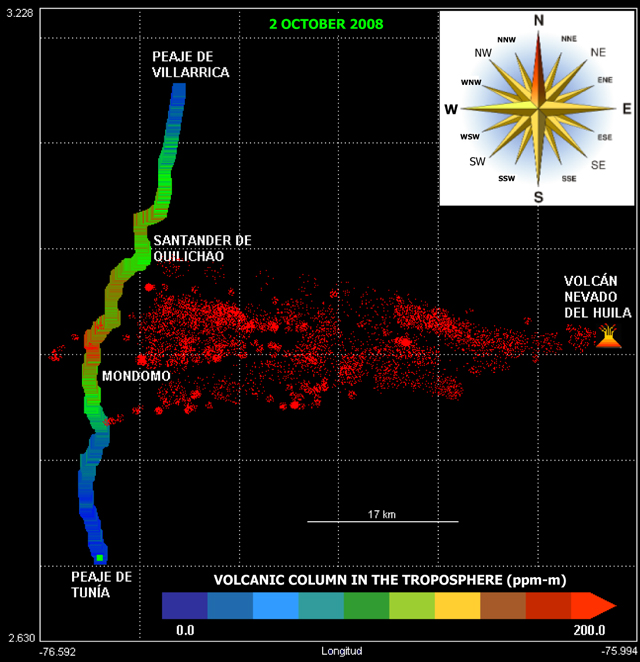 |
Figure 21. On 2 October 2008, INGEOMINAS conducted a gas survey to measure SO2 emissions from Nevado del Huila with a mobile DOAS. This image shows the route followed by investigators along the Pan-American Highway between the locations of Peaje de Villarrica and Peaje de Tunía; Popayán (73.5 km S of Mondomo) and Calí (~69 km N of Mondomo) are out of view. The approximate location of the gas plume and the volcano were added to the raw image for visual references. Note that the highest concentration-pathlength of SO2, ~200 ppm-m (parts per million per meter), was encountered N of the town Mondomo. Courtesy of INGEOMINAS. |
INGEOMINAS recorded significant increases in LP and tremor seismicity in October 2008 (table 2). LP earthquakes more than doubled and tremor had increased from 34 to 537 events since the previous month. VT events had occurred slightly less frequently (1,437 events in October compared to 1,722 events in September), and there were fewer hybrid events recorded.
Elevated activity in early November 2008. In early November, residents of Wila, Tóez, and Plan de Caloto along the Páez River (approximately 2-7 km to the SW) reported ashfall and strong sulfur odors following an intense period of seismicity on 3 November. Inhabitants on the S side of the volcano observed that gas emissions changed color from white to gray for short intervals.
Continuous seismic tremor was detected on 7 November and prompted an increase in the Alert Level from Yellow to Orange. INGEOMINAS reported that the volcano had entered a phase of unrest that could lead to hazardous conditions.
With the assistance of the Colombian Air Force, scientists aboard flights on 8 and 9 November observed cracks forming on the S side of Pico Central and traces of mudflows and ash originating from Pico Central that were thought to have contributed to the murky water in the Páez River during preceding days. Twenty families evacuated from the Símbola River on the E flank after increased seismic and fumarolic activity. A team of civil servants from Popayán was deployed to Belalcázar and Inzá to coordinate evacuations in the event of an eruption. The mayor of the Páez municipality closed schools in areas surrounding the Páez River and announced evacuation routes.
During the second week of November 2008, INGEOMINAS reported that, on average, 1,210 earthquakes were occurring per day. Earthquakes related to dynamic fluids (LP events) continued to dominate seismic records and INGEOMINAS described these events as possible evidence of a magma system migrating to the surface. They continued to receive reports of sulfur odors and ashfall in local regions W and SW of the edifice.
During 7-17 November, the Washington Volcanic Ash Advisory Center (VAAC) reported possible ash plumes from Nevado del Huila, however, satellite observations were limited due to persistent cloud cover. On 9, 10, 13, and 14 November, clear satellite views of the region revealed ash plumes up to ~9.25 km wide and ~37 km long drifting from the volcano. On 9 and 10 November, ash plumes reached ~5.5 km altitude and tended to drift W; communities located up to 20 km NW of Nevado del Huila reported ashfall on the morning of 10 November. On 13 and 14 November, ash plumes reached 6.7 km altitude and drifted SW and S, respectively.
On 14 November, scientists identified a conspicuous "drumbeat" pattern of seismicity underneath the volcano, signifying the movement of magma and the potential buildup to an eruption (figure 22). This pattern intensified over the next six days.
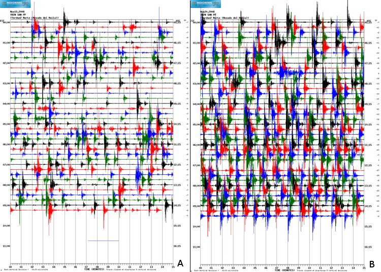 |
Figure 22. "Drumbeat" pattern of seismicity detected at Nevado del Huila prior to the 20 November 2008 eruption: (a) 15 November 2008, and (b) 19 November 2008. Each line is 15 minutes long and color-coded (red, blue, green, and black) as a visual aid to distinguish lines; local time is recorded at the beginning and end of each line. Courtesy of INGEOMINAS. |
Drumbeat earthquakes. The term "drumbeat" was coined by scientists during the onset of the Mount St. Helens (MSH) 2004 eruption (BGVN 30:12). After a series of seismic swarms, tremor, and explosions from the crater, USGS scientists noted that regular, impulsive seismic signals were detected at shallow depths beneath the Mount St. Helens dome on 16 October 2004; this pattern of seismicity continued until the end of 2005 (Moran and others, 2008).
“Seismograms showed that drumbeat waveforms typically had impulsive, high-frequency onsets and low-frequency codas, similar to those of other ‘hybrid’ volcanic earthquakes...all drumbeats originated at depths
Eruption during 20-21 November 2008. At 2145 on 20 November 2008, Nevado del Huila erupted. Two large lahars swept into the Páez River, claiming 10 lives and destroying bridges, houses, and pastures. According to the UN Office for the Coordination of Humanitarian Affairs (OCHA), the lahars had heights of as much as 30 meters, traveled down the Páez river, and joined the Magdalena River, which feeds the Betania reservoir in Yaguara municipality in Huila department; the reservoir cushioned the impact of the mud flows moving downstream. The inhabitants of Taravira (~22 km S), Toez (~15 km SSW), and La Estrella reported significant ashfall and loud noises likely associated with lahars in nearby drainages. By the following day, seismic activity diminished significantly, and the Alert Level was lowered from Red (I, posted during the eruption) to Orange (II).
The Washington VAAC detected two large plumes of gas and ash at 0345 on 21 November with altitudes ~14 km and ~11 km drifting SE and W, respectively. Two additional alerts were released (at 0445 and 1045) that tracked the ash plumes as they continued to drift at velocities up to 10 m/s SE and W.
During two observation flights conducted with the support of the Colombian Air Force, observers saw a 400-m-diameter crater in the S part of Pico Central containing a degassing lava dome on 21 November (figure 23). The lava dome was thought to have formed during previous months, but had not been visible due to poor weather conditions prior to the eruption. Lahars were observed to originate from the upper flanks of the volcano and extend into the Páez River basin (figure 24). Strong fumarolic activity was observed along the large cracks in the volcano from previous eruptions. INGEOMINAS reported that they would continuously monitor the lava dome for future hazards, but that they believed that the late November eruption had ended.
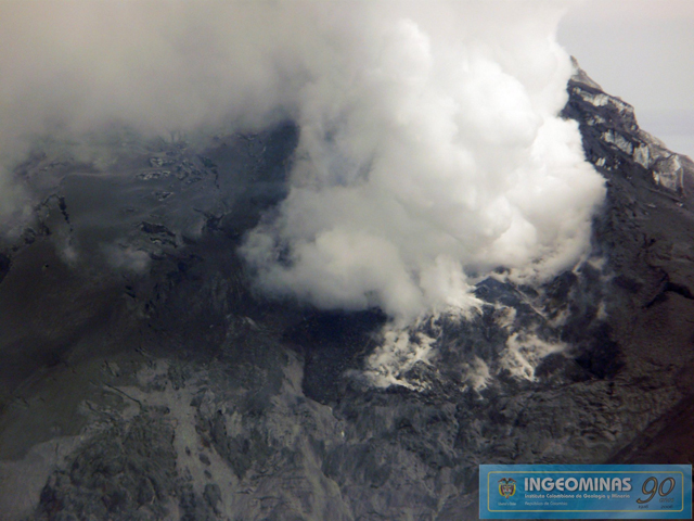 |
Figure 23. Aerial photo of Nevado del Huila's degassing lava dome on 21 November 2008. This view is toward the S-facing summit of Pico Central. Courtesy of INGEOMINAS. |
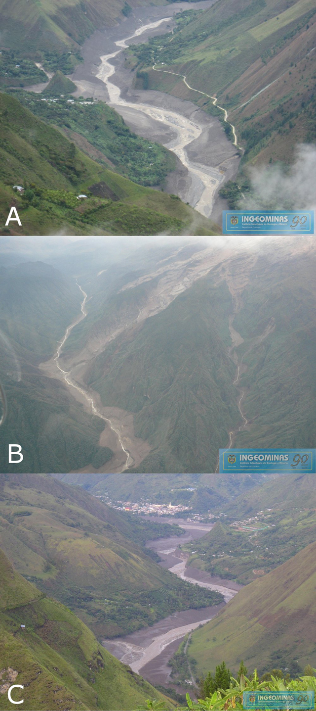 |
Figure 24. Aerial photos of mudflows into the Páez River after the 20 November 2008 eruption of Nevado del Huila. (A and B) Views along the Páez River. (C) A view of Belalcázar from Togoima. Courtesy of INGEOMINAS. |
Human toll and humanitarian response. On 23 November 2008, the National Direction for Prevention and Assistance (DPAD) reported that six people had died (three boys, one girl and two men) and three people were missing. The International Federation's Disaster Relief Emergency Fund (DREF) reported that over 8,000 people were affected by the lahars (table 3). On 21 November, President Alvaro Uribe flew over the disaster area to observe the damage. Afterward, he designated a special commission to oversee the repair of infrastructure damaged by the mudflows. Destruction of bridges and roads made humanitarian aid to the area difficult, especially to more isolated communities, but the Colombian Air Force (FAC) provided air support to ease relief efforts.
Table 3. Human impact of the 20 November 2008 Nevado del Huila eruption. Adapted from ReliefWeb DREF report.
| Category | Number of People |
| People evacuated during the eruption phase | 6,000 |
| People affected after the eruption | 2,864 |
| Casualties | 10 |
| Injured | 7 |
| Missing | 6 |
| Houses destroyed in urban areas | 40 |
| Houses destroyed in rural areas | 7 |
| Houses damaged in urban areas | 75 |
| Houses damaged in rural areas | 14 |
DREF funding had been awarded to the Colombian Red Cross Society (CRCS) in April 2008 to provide disaster aid. Temporary shelters set up by the CRCS in Belalcázar were crude but successfully sheltered nearly 1,000 people early in the relief efforts. The Colombian government and the National System for Disaster Preparedness and Response (SNPAD) provided over 98 tons of humanitarian relief distributed by SNPAD, CRCS, FAC, and other organizations.
Activity during December 2008. After the November eruption, volcanic unrest significantly decreased. Seismic activity decreased to less than 500 events per week (table 2), and SO2 emissions decreased to approximately 2,500 t/d (figure 18). Overflights were conducted on 4 and 6 December to observe the degassing lava dome; gases were primarily rising from the highest portions of the dome, producing a white plume reaching less than 1,000 m above the peak (figure 25). New fractures were also observed in the surface of Pico Central's glaciers. INGEOMINAS reported an estimated lava-dome volume of 4,500,000 m3. A more recent estimate, however, was proposed in an online December report by INGEOMINAS citing 32,000,000 m3 with dimensions of 700 m N-S and 250 m E-W.
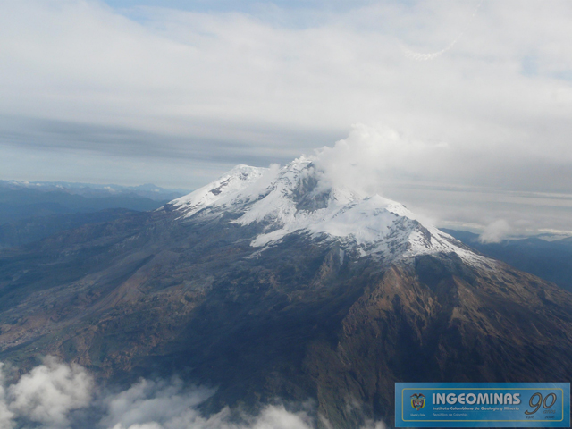 |
Figure 25. On 6 December 2008 INGEOMINAS captured this image of Nevado del Huila. The new lava dome appears dark gray against the snowy peak, Pico Central. This view is looking approximately NNE. Courtesy of INGEOMINAS. |
On 12 December 2008, a webcam was installed within the SSW sector of Nevado del Huila and by 18 December began to provide continuous visual monitoring of changes in the dome. Installed at Tafxnú (viewing the NW flank of Nevado del Huila), the camera was programmed to refresh the images every minute. This equipment was a donation from the U.S. Geological Survey.
On 18 December a permanent station dedicated to the monitoring of SO2 emissions was installed in the town of Caloto (Cauca). Elevated SO2 emissions continued to the end of December and were detected by the AURA/OMI satellite. Sulfur dioxide odors were noted by a commercial airline crew at 0158 on 30 December.
References. Iverson, R.M., Dzurisin, D., Gardner, C.A., Gerlach, T.M., LaHusen, R.G., Lisowski, M., Major, J.J., Malone, S.D., Messerich, J.A., Moran, S.C., Pallister, J.S., Qamar, A.I., Schilling, S.P., and Vallance, J.W. (2006) Dynamics of seismogenic volcanic extrusion at Mount St Helens in 2004-05, Nature, 444: 439-443.
Moran, S.C., Malone, S.D., Qamar, A.I., Thelen, W.A., Wright, A.K., and Caplan-Auerbach, J. (2008) Seismicity associated with renewed dome building at Mount St. Helens, 2004-2005. In Sherrod, D.R., Scott, W.E., Stauffer, P.H. (eds) A volcano rekindled: the renewed eruption of Mount St. Helens, 2004-2006. U.S. Geological Survey Professional Paper 1750: 27-60.
Geological Summary. Nevado del Huila, the highest peak in the Colombian Andes, is an elongated N-S-trending volcanic chain mantled by a glacier icecap. The andesitic-dacitic volcano was constructed within a 10-km-wide caldera. Volcanism at Nevado del Huila has produced six volcanic cones whose ages in general migrated from south to north. The high point of the complex is Pico Central. Two glacier-free lava domes lie at the southern end of the volcanic complex. The first historical activity was an explosive eruption in the mid-16th century. Long-term, persistent steam columns had risen from Pico Central prior to the next eruption in 2007, when explosive activity was accompanied by damaging mudflows.
Information Contacts: Instituto Colombiano de Geologia y Mineria (INGEOMINAS), Observatorio Vulcanológico y Sismológico de Popayán, Popayán, Colombia; Washington Volcanic Ash Advisory Center (VAAC), NOAA Science Center Room 401, 5200 Auth road, Camp Springs, MD 20746, USA (URL: http://www.ospo.noaa.gov/Products/atmosphere/vaac/); Ozone Monitoring Instrument (OMI), Sulfur Dioxide Group, Joint Center for Earth Systems Technology, University of Maryland Baltimore County (UMBC), 1000 Hilltop Circle, Baltimore, MD 21250, USA (URL: https://so2.gsfc.nasa.gov/); United Nations Office for the Coordination of Humanitarian Affairs (OCHA) (URL: http://www.unocha.org/); International Federation’s Disaster Relief Emergency Fund (DREF) (URL: http://www.ifrc.org/); Colombian Red Cross Society (CRCS) (URL: http://www.cruzrojacolombiana.org/); ReliefWeb (URL: https://reliefweb.int/report/colombia/colombia-volcano-dref-operation-no-mdrco005-final-report); El Tiempo (URL: http://www.eltiempo.com/archivo/documento/CMS-4100993).