Report on Tangkuban Parahu (Indonesia) — November 2012
Bulletin of the Global Volcanism Network, vol. 37, no. 11 (November 2012)
Managing Editor: Richard Wunderman.
Tangkuban Parahu (Indonesia) Earthquakes and hot gas emissions in August 2012
Please cite this report as:
Global Volcanism Program, 2012. Report on Tangkuban Parahu (Indonesia) (Wunderman, R., ed.). Bulletin of the Global Volcanism Network, 37:11. Smithsonian Institution. https://doi.org/10.5479/si.GVP.BGVN201211-263090
Tangkuban Parahu
Indonesia
6.77°S, 107.6°E; summit elev. 2084 m
All times are local (unless otherwise noted)
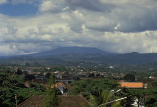
Our most recent report on Tangkubanparahu (also known as Tangkuban Perahu) described increased seismicity during April 2005, consisting primarily of volcanic earthquakes and tremor (BGVN 30:12). This report describes elevated seismicity during August-September 2012. The Center of Volcanology and Geological Hazard Mitigation (CVGHM) notes that at least three magmatic eruptions and four phreatic eruptions had occurred at Ratu Crater, the most active vent, during 1829-1994. Ratu Crater is about 30 km N of Bandung in W Java. Figure 1 indicates the general location of the volcano.
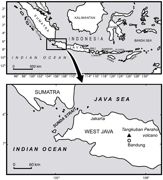 |
Figure 1. Sketch maps of Indonesia and W Java indicating the location of Tangkubanparahu (Tangkuban Perahu). Courtesy of Kartadinata and others (2002). |
The next report we received on Tangkubanparahu described activity starting in August 2012. According to CVGHM, the frequency of earthquakes and tremor increased on both 13 and 23 August. Around this time, hot blasts of sulfuric gases, white in color, rose from Ratu Crater to heights of 50-400 m above the crater's floor. CVGHM reported that the temperature of emissions from Ratu Crater on 24 August was 246°C, compared to a measurement of 111°C on 18 August. On 23 August, the Alert Level was raised to 2 (on a scale of 1-4), and visitors and residents were prohibited within a 1.5-km radius of the active crater.
Seismic activity declined on 23 August; shallow volcanic earthquakes continued to be recorded but were less frequent through 21 September (table 2 provides data through 20 September). Hypocenters of volcanic tremors during this period were located beneath an area W of Ratu Crater at depths of 4-12 km. Soil temperatures at Ratu Crater were 30.5°C on 26 August, then were 35°C on 30 August, but then gradually declined during 31 August-21 September to ~34°C.
Table 2. Type and occurrence of earthquakes at Tangkubanparahu between 24 August and 20 September 2012. Courtesy of CVGHM.
| Date | Shallow Volcanic | Deep Volcanic | Distant Tectonic | Local Tectonic | Air Blast | Tremor episodes (amplitude; duration) |
| 24 Aug-30 Aug 2012 | 76 | 11 | 1 | 2 | -- | 1 (3-16 mm; 8,100 sec.) |
| 31 Aug-06 Sep 2012 | 66 | 12 | 8 | 3 | 19 | 3 (1-30 mm; 60-18,000 sec.) |
| 07 Sep-13 Sep 2012 | 42 | 6 | 3 | 2 | 53 | 7 (1-10 mm; 63-1,842 sec.) |
| 14 Sep-20 Sep 2012 | 27 | 19 | 13 | 4 | 33 | 5 (5-14 mm; 171-600 sec.) |
Between 5-11 September, sulfur dioxide gas emissions were elevated in an area NW of the crater associated with the plume, but in the latter part of September 2012 concentrations averaged4in Ratu Crater increased from 0.11 in December 2011 to ~4 on 24 August 2012 and remained at that level on 11 September 2012, which suggested to CVGHM that hot fluid was rising to the surface.
Based on seismicity, visual observations, deformation data, gas measurements, and soil and crater lake water temperatures, the Alert Level was lowered to 1 on 21 September 2012.
The eruptive history of Tangkubanparahu was described by Kartadinata and others (2002).
Reference. Kartadinata, M., Okuno, M., Nakamura, T., and Kobayashi, T., 2002, Eruptive history of Tangkuban Perahu volcano, West Java, Indonesia: A preliminary report, Journal of Geography, v. 111, issue 3, p. 404-409.
Geological Summary. Gunung Tangkuban Parahu is a broad stratovolcano overlooking Indonesia's former capital city of Bandung. The volcano was constructed within the 6 x 8 km Pleistocene Sunda caldera, which formed about 190,000 years ago. The volcano's low profile is the subject of legends referring to the mountain of the "upturned boat." The Sunda caldera rim forms a prominent ridge on the western side; elsewhere the rim is largely buried by deposits of the current volcano. The dominantly small phreatic eruptions recorded since the 19th century have originated from several nested craters within an elliptical 1 x 1.5 km summit depression.
Information Contacts: Center of Volcanology and Geological Hazard Mitigation (CVGHM), Jalan Diponegoro 57, Bandung 40122, Indonesia (URL: http://www.vsi.esdm.go.id/).