Report on Gamalama (Indonesia) — November 2012
Bulletin of the Global Volcanism Network, vol. 37, no. 11 (November 2012)
Managing Editor: Richard Wunderman.
Gamalama (Indonesia) Seismicity precedes small ash-bearing eruptions in September 2012
Please cite this report as:
Global Volcanism Program, 2012. Report on Gamalama (Indonesia) (Wunderman, R., ed.). Bulletin of the Global Volcanism Network, 37:11. Smithsonian Institution. https://doi.org/10.5479/si.GVP.BGVN201211-268060
Gamalama
Indonesia
0.81°N, 127.3322°E; summit elev. 1714 m
All times are local (unless otherwise noted)
This report discusses a series of small but punctuated eruptions on 15-17 September 2012 associated with the return of seismicity at Gamalama. Fog obscured visibility but ash fell on inhabited areas. The eruptions were judged similar to those seen 4 December 2011 (BGVN 36:12).
As we noted previously, heavy rains after the 4 December 2011 eruptions led to lahars on 27-28 December that killed four people, injured dozens, and displaced thousands (BGVN 36:12). Photos showed that these lahars had carried many meter-diameter blocks into inhabited areas on the lower flanks. Videos from helicopter flights confirmed that in the upslope region, chutes and drainages had also fed finer ash into the lahars.
According to the Center for Volcanology and Geological Hazard Mitigation (CVGHM), on 24 January 2012, after witnessing an interval of generally reduced seismicity, an absence of significant ash-bearing plumes, and weak steam plumes rising only ~100 m above the summit, they lowered the Alert Level from 3 to 2 (on a scale from 1-4).
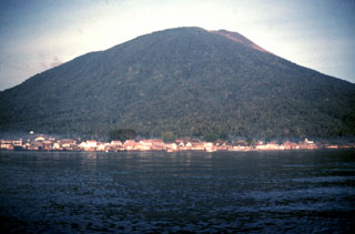
As geographic background, Gamalama volcano emerges from the sea to form the near-conical 76 km2 Ternate island. The island is situated in the Molucca (Maluku) islands in NE Indonesia about midway between the islands of Borneo and New Guinea (figure 5).
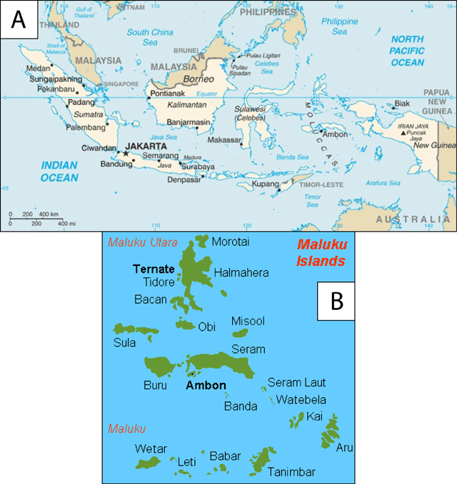 |
Figure 5. (A) An index map of Indonesia, including the Molucca islands and regional landmarks. Courtesy of U.S. Department of State. (B) A map of the Molucca (Maluku) islands, highlighting Gamalama (Ternate). Courtesy of Indonesia Explore. |
Seismicity and eruptions of September 2012. Significant seismicity and other activity at Gamalama remained low from early 2012 until September. During 1-14 September white plumes were sometimes observed rising ~10 m above the crater. When visibility allowed, these plumes were observed from the local obseratory post at Marikuruba and from the W coast of the island, but fog and clouds generally obscured the view.
The telemetered seismograph system (PS-2) recorded deep volcanic earthquakes, shallow volcanic earthquakes, and local tectonic earthquakes, each occurring fewer than five times during 1-14 September. During that same period, there were 63 long-distance tectonic earthquakes and 42 hot air blasts recorded; once they began, signals interpreted as the hot air blasts amounted to 8 occurrences per day. Visual observations and tremor during this time period appeared similar to this volcano's past behavior.
On 15 September 2012 the following seismic events were recorded: 6 long distance tectonic earthquakes, 9 deep volcanic earthquakes, 2 shallow volcanic earthquakes, 14 hot air blasts accompanied by rumbling sounds, and an interval of tremor began with amplitudes reaching 3-4 mm. Six minutes after the tremor, eruption signals occurred with a maximum amplitude of 40 mm. A phreatic explosion produced ash fall and debris fall. Fog obscured the visibility.
On 16 September 2012, CVGHM reported low-amplitude tremor continuing during 0000-1200 (with 1.5-2.5 mm amplitudes). Medium-to-heavy rain fell at the summit around 1200. At 1358 tremor amplitudes increased to 28 mm, followed 17 min later by a "severe eruption."
That eruption drove an ash-laden plume to ~1 km above the crater. The plume drifted S and SE (figure 6A), and 5 min later ash fell at the observation post. The Alert Level was raised to 3 and visitors and residents were warned not to come within 2.5 km of the crater. CVGHM suggested that the eruption vented at the same location as those of December 2011.
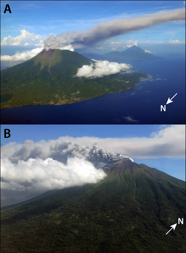 |
Figure 6. (A) Photo of the Gamalama eruption on 16 September 2012 viewed from the NW. The ash plume is immediately blown to the S and SE with almost no vertical development. (B) The 17 September 2012 eruption of Gamalama viewed from the ESE. Both photos courtesy of Associated Press and The Jakarta Globe. |
An eruption on 17 September 2012 produced a white-and-gray plume that rose 300 m above the crater and drifted E and SE (figure 6B). Ashfall was reported in the S, SE, and E parts of the island.
Calm prevailed for at least a few weeks after the eruption. Seismicity decreased in early October; on 8 October white plumes rose a mere 10-50 m. The Alert Level was lowered to 2 on 9 October, and the resulting exclusionary zone extended 1.5 km from the crater.
Geological Summary. Gamalama is a near-conical stratovolcano that comprises the entire island of Ternate off the western coast of Halmahera, and is one of Indonesia's most active volcanoes. The island was a major regional center in the Portuguese and Dutch spice trade for several centuries, which contributed to the extensive documentation of activity. Three cones, progressively younger to the north, form the summit. Several maars and vents define a rift zone, parallel to the Halmahera island arc, that cuts the volcano; the S-flank Ngade maar formed after about 14,500–13,000 cal. BP (Faral et al., 2022). Eruptions, recorded frequently since the 16th century, typically originated from the summit craters, although flank eruptions have occurred in 1763, 1770, 1775, and 1962-63.
Information Contacts: Center for Volcanology and Geological Hazard Mitigation (CVGHM), Jl. Diponegoro 57, Bandung, West Java, Indonesia, 40 122 (URL: http://www.vsi.esdm.go.id/); Darwin Volcanic Ash Advisory Centre (VAAC), Bureau of Meteorology, Northern Territory Regional Office, PO Box 40050, Casuarina, NT 0811, Australia (URL: http://www.bom.gov.au/info/vaac/); The Jakarta Post, Jl. Palmerah Barat 142-143, Jakarta 10270, Indonesia (URL: http://www.thejakartapost.com/); Associated Press (AP) (URL: http://www.apimages.com/); USA Today, 7950 Jones Branch Road, McLean, VA 22102 (URL: http://www.usatoday.com/); BBC News (URL: http://www.bbc.co.uk/); United States Department of State - Bureau of Consular Affairs (URL: http://travel.state.gov/); Indonesia Explore (URL: http://indonesiaexplore.com/).