Report on Sundoro (Indonesia) — August 2013
Bulletin of the Global Volcanism Network, vol. 38, no. 8 (August 2013)
Managing Editor: Richard Wunderman.
Sundoro (Indonesia) Fumarolic and seismic activity in late 2011 results in brief rise in alert level
Please cite this report as:
Global Volcanism Program, 2013. Report on Sundoro (Indonesia) (Wunderman, R., ed.). Bulletin of the Global Volcanism Network, 38:8. Smithsonian Institution. https://doi.org/10.5479/si.GVP.BGVN201308-263210
Sundoro
Indonesia
7.302°S, 109.996°E; summit elev. 3147 m
All times are local (unless otherwise noted)
The last eruption reported for Sundoro volcano occurred 29 October 1971; however, that did not stimulate a resulting Bulletin report and this is our first on this volcano. According to Indonesian Center of Volcanology and Geological Hazard Mitigation (CVGHM), visual observations of Sundoro volcano during October - 4 December 2011 indicated 'smoke' from fumaroles around the summit crater. Average fumarole temperatures of 75°C on 26 October and 95°C on 2 November 2011 were measured. On November 2, the height of the 'smoke' had passed the rim of the volcano's crater. Seismic activity, especially volcanic earthquakes (deep volcanic tremors-VA, and shallow volcanic tremors-VB), began to increase in November 2011. On 5 December 2011, the Alert status (on a scale of I to IV) for Sundoro was raised from Normal (Level I) to Alert (Level II). Seismicity remained elevated through the first week of January 2012.
Throughout the rest of January, February, and through March 2012, a significant decrease of volcanic earthquakes (both VA and VB) was noted. Thus, the Alert status was lowered to Level I on 30 March 2012.
The area of Mt. Sundoro (also known as Sindoro; close to Mt. Sumbing) on Java (see figure 1 in BGVN 33:11), was the subject of a study of people's perceptions and reactions to volcanic hazards (Lavigne and others, 2008).
Reference: Lavigne, F., De Coster, B., Juvin, N., Flohic, F., Gaillard, J-C., Texier, P., Morin, J., and Sartohadi, J., 2008, People's behaviour in the face of volcanic hazards: Perspectives from Javanese communities, Indonesia, Journal of Volcanology and Geothermal Research, v.172, issue 3-4, p. 273-287.
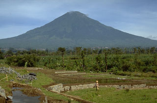
Geological Summary. Gunung Sundoro, one Java's most symmetrical volcanoes, is between the Dieng complex to the NW and Sumbing volcano to the SE. The large Kembang cone is about 2.5 km from teh summit on the SW flank. A small lava dome occupies the summit crater, and numerous phreatic explosion vents are present in the summit area. Lava flows extend in all directions from the summit crater. Deposits of a large prehistoric debris avalanche are located below the NE flank. Pyroclastic-flow deposits dated at 1,720 years before present extend as far as 13 km from the summit. Historical eruptions typically have consisted of mild-to-moderate phreatic explosions, mostly from the summit crater. Flank vents were also active in 1882 and 1903.
Information Contacts: Center of Volcanology and Geological Hazard Mitigation (CVGHM) (URL: http://www.vsi.esdm.go.id/).