Report on Copahue (Chile-Argentina) — September 2013

Bulletin of the Global Volcanism Network, vol. 38, no. 9 (September 2013)
Managing Editor: Richard Wunderman.
Edited by Julie A. Herrick.
Copahue (Chile-Argentina) Small ash eruptions during 2012-2013
Please cite this report as:
Global Volcanism Program, 2013. Report on Copahue (Chile-Argentina) (Herrick, J.A., and Wunderman, R., eds.). Bulletin of the Global Volcanism Network, 38:9. Smithsonian Institution. https://doi.org/10.5479/si.GVP.BGVN201309-357090
Copahue
Chile-Argentina
37.856°S, 71.183°W; summit elev. 2953 m
All times are local (unless otherwise noted)
Our last report on Copahue volcano described the phreato-magmatic eruption of July 2000 (BGVN 25:06). Up until July 2012, activity at Copahue was characterized by passive degassing. In this report, we summarize the changes registered from Copahue which culminated in minor ash eruptions. According to Instituto Nacional de Prevención Sísmica (INPRES), a phreatic eruption occurred on 19 July 2012 and Servicio Nacional de Geologia y Mineria (SERNAGEOMIN) reported that ash emissions continued intermittently during December 2012-December 2013.
INPRES and Forte and others (2012) noted that seismicity increased in the region of Copahue after the Mw 8.8 earthquake that occurred 3 km W of the Chilean shoreline on 27 February 2010. This activity was coincident with a progressive increase in fumarolic activity from the crater lake, El Agrio. A dense plume of vapor and acidic gases were frequently observed between 200-300 meters above the crater rim (figure 7).
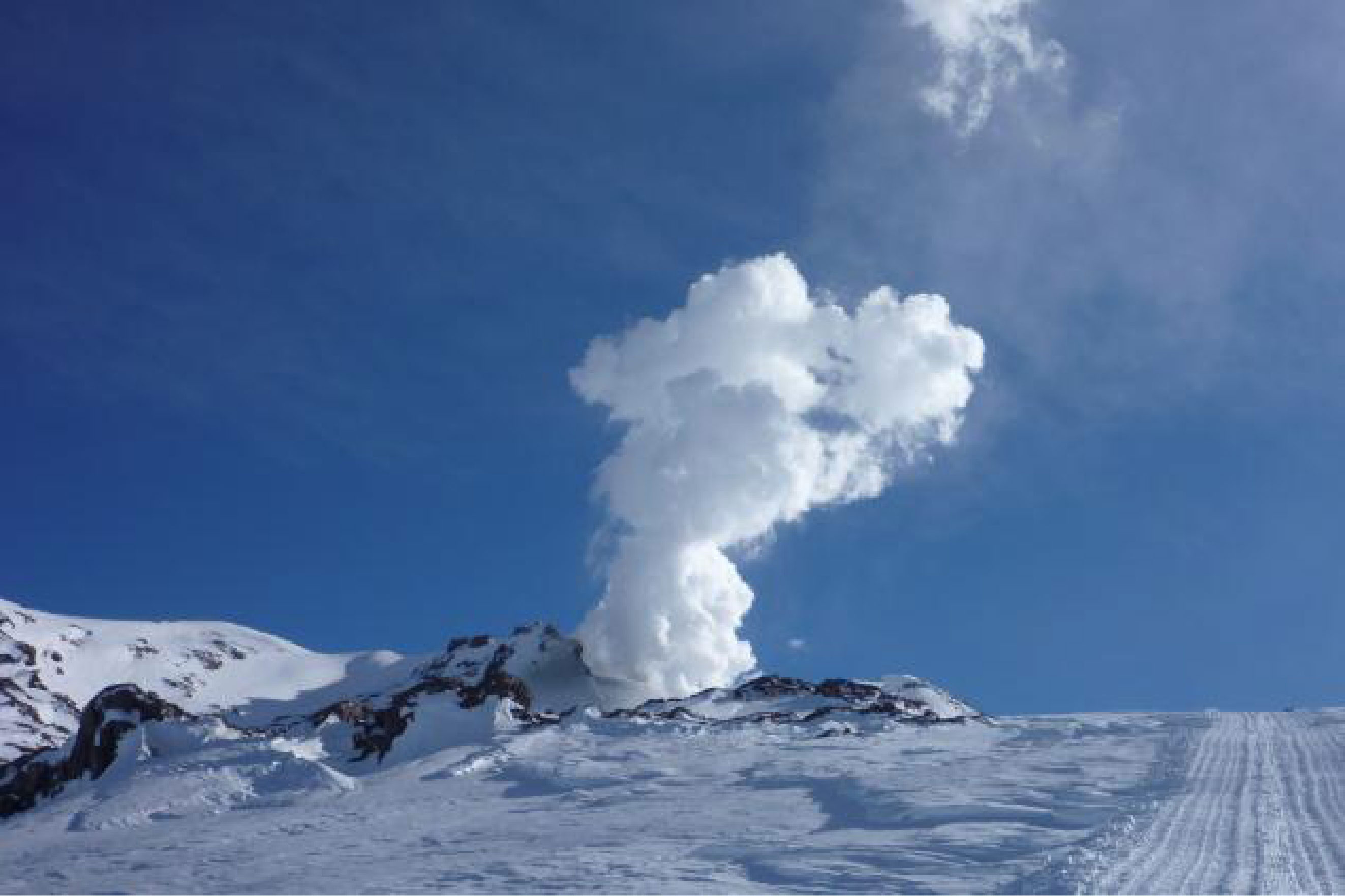 |
Figure 7. Vapor and acidic gases rose in a column from Copahue crater lake on 17 July 2012. Courtesy of Nicolas Sieburger, a local guide who frequented the area. |
According to Vélez and others (2011), differential interferometry (DInSAR) studies performed with ENVISAT radar images of Copahue's flanks suggested changes in deformation trends dominated by deflation during 2003-2008 and inflation during November-December 2011. A deformation map constructed between November 2011 and Aril 2012 showed uplift with displacements up to 7 cm (Vélez, 2012).
During March 2012, acidic water from the crater lake and hot springs on the E flank of the volcano was analyzed by Caselli and others (2012) and Agusto and others (in progress). The acidity (pH2, Cl, and F) showed unusually high values. These investigators also highlighted a significant decrease in the level of Copahue's crater lake waterline.
In July 2012, several seismic events of high and low frequency spectral content were reported by INPRES. Simultaneously, intense bubbling was observed in the SW area of Copahue's crater at an interval of 1 to 3 minutes (figure 8). A small explosion was reported on 17 July 2012 and photographed by a local guide (figure 9); it consisted of phreatic manifestations up to 10 meters high.
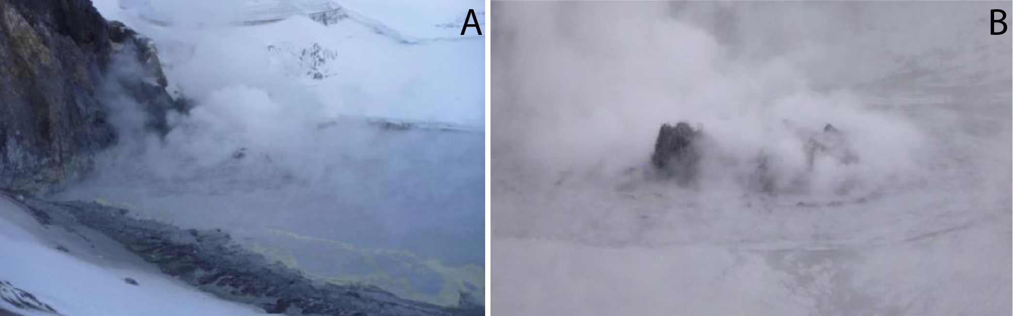 |
Figure 8. The crater lake of Copahue volcano on 17 July 2012: (A) the main emission point of intense bubbling was associated with steam, gas, and patches of sulfur floating on the lake surface; (B) detail of the area of bubbling. Courtesy of NicolÁs Sieburger. |
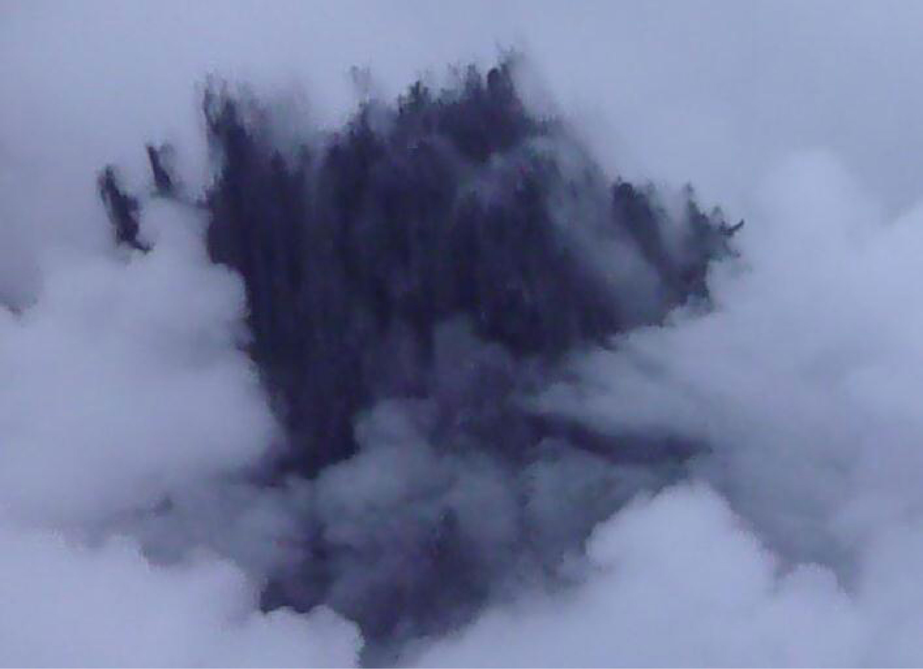 |
Figure 9. A phreatic explosion from the SW sector of Copahue's crater lake during 17 July 2012. Although this photo lacks a scale and includes local clouds and/or steam, it is clear that the eruption plume was nearly black in color. Courtesy of Nicolás Sieburger. |
On 19 July 2012, another phreatomagmatic explosion occurred with emissions of pyroclastic material that, according to SERNAGEOMIN, producing a plume that extending for ~18 km ESE (figure 10). The resulting proximal tephra included ash and fine- and coarse-sized lapilli up to 20 cm in diameter. A sample of this event recovered from the crater mainly consisted of sulfur-rich clasts with a low percentage of pumice fragments, scoriae fragments, irregular argillaceous white material, and accidental fragments. The pyroclastic material sampled displayed variable sizes (3-4 mm in diameter), mostly including globular morphology, and contained vesicles. Other morphologies included perfect spheres and elongated forms and like deformed drops (figure 11, A and B). Regarding glassy particles, different classes were identified according presence, size and shape of the vesicles, as vitreous pumiceous shards, platy, cuspate and blocky glass shards (figure 11 C and D). Further details of the particle morphology were obtained with SEM analysis (figure 12). Vitreous fragments showed similar composition to those described in 2000 eruption.
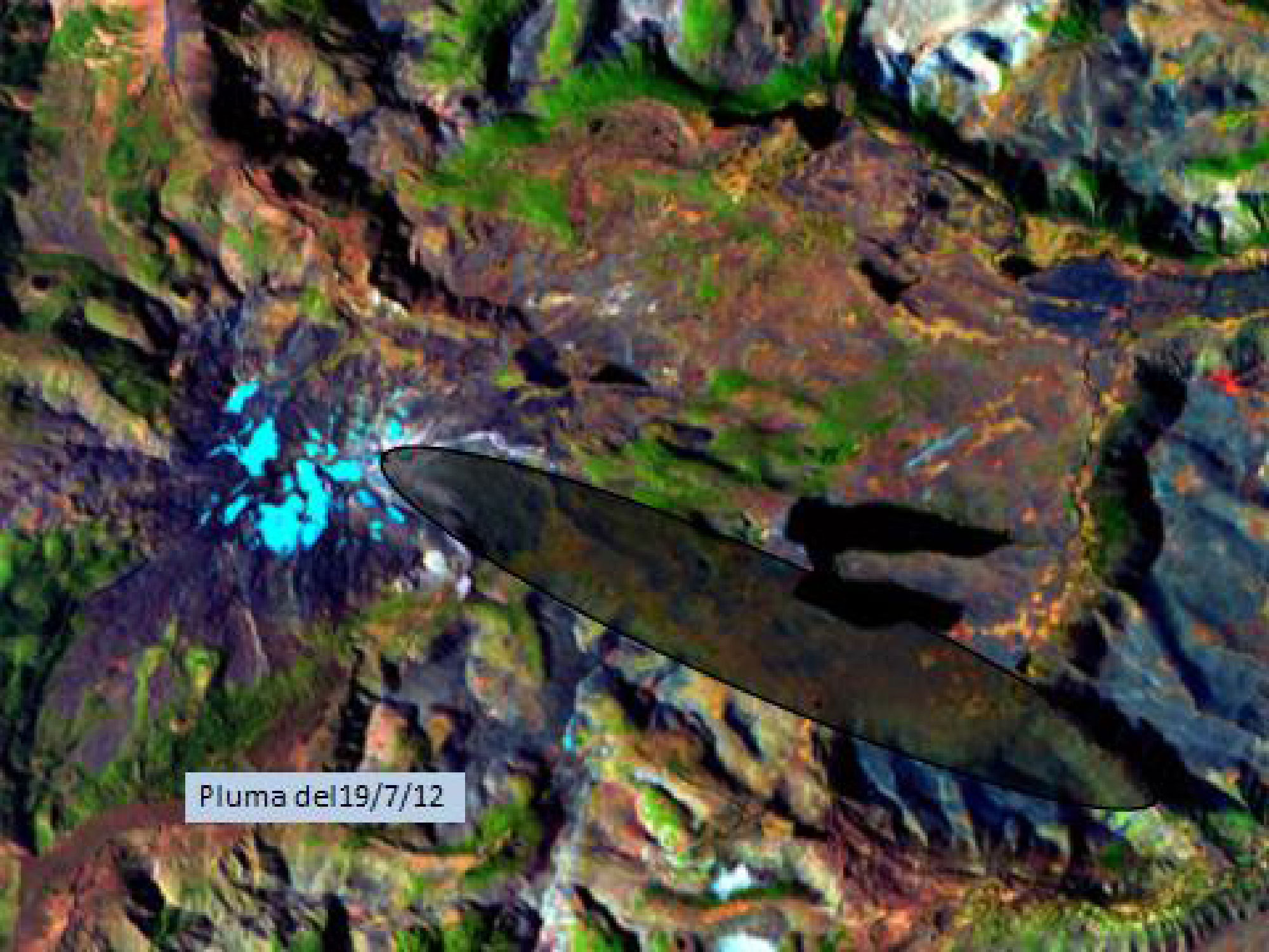 |
Figure 10. In this false-color Landsat satellite image of Copahue, the region affected by the 19 July 2012 ash plume is within the 20 km long, ESE-trending ellipse. Courtesy of Laura Vélez (GESVA). |
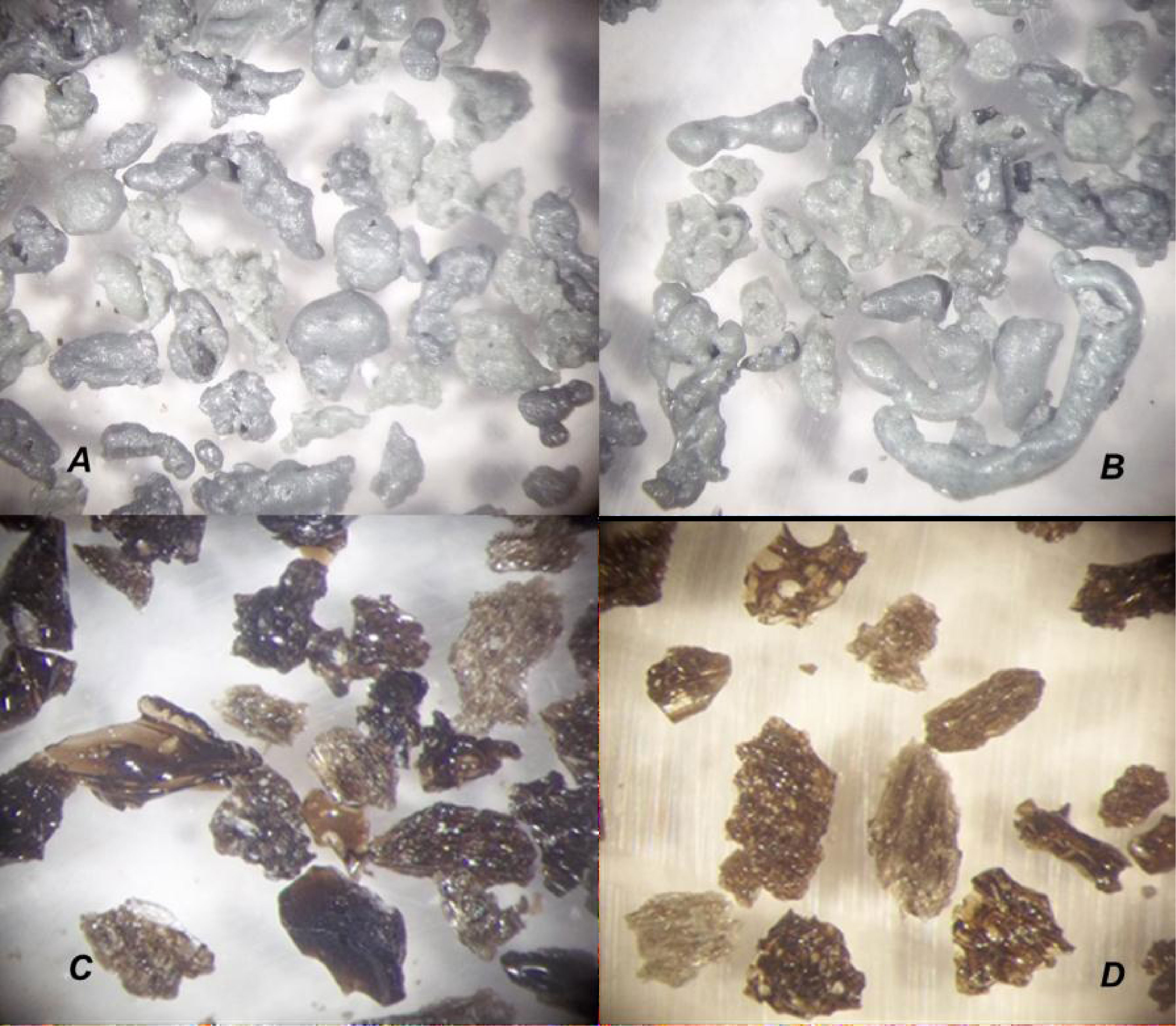 |
Figure 11. Low magnification photo micrographs looking at key components from Copahue's July 2012 tephra deposits. Fragments shown are less than 4 mm in diameter and were chosen to highlight morphologic differences between sulfur particles (A and B) and vitreous shards (C and D). Photograph by R. Daga, Laboratorio Análisis por Activación Neutrónica (CAB-CNEA). |
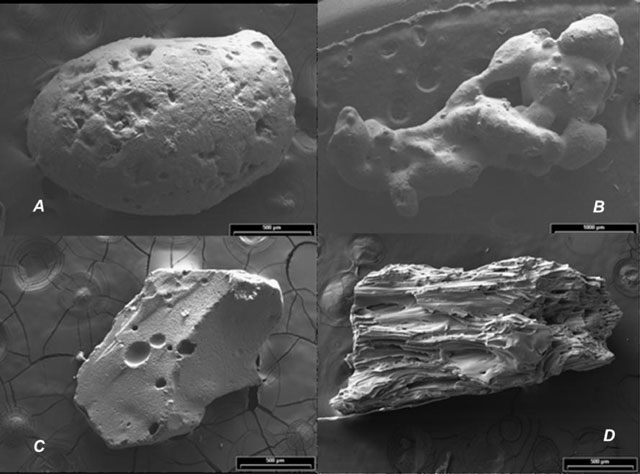 |
Figure 12. Scanning Electron Microscope (SEM) images of particles deposited from Copahue's July 2012 eruption. Images as follows: (A) subspherical sulfur particle; (B) botryoidal sulfur particle; (C) blocky and glassy particle; (D) fibrous glassy particles. Note the scale bars represent 500 μm for images A, C, and D while the scale bar for B is 1000 μm. Photograph by R. Daga, Laboratorio Análisis por Activación Neutrónica (CAB-CNEA). |
A seismic array from the Grupo de Estudio y Seguimiento de Volcanes Activos (GESVA) had been installed near the town of Caviahue and it registered a wide range of seismicity during July 2012. GESVA documented volcano-tectonic events, hybrid events, long period events, tremor at various frequency ranges including harmonic tremor, and explosions. Several seismic swarms were reported during the phreatomagmatic eruption on 19 July 2012. GESVA is an investigative program within the geological department of the University of Buenos Aires.
On 26 July 2012 GESVA researchers conducted a new survey of the crater lake. All physical and chemical parameters showed high values with temperatures of 60°C at the lake margin, high acidity (pH
Continued unrest December 2012-December 2013. The Observatorio Volcanológico de los Andes del Sur-Servicio Nacional de Geologia y Mineria (OVDAS-SERNAGEOMIN) reported on 22 December 2012 an alert change from Orange to Red Alert at Copahue. This report highlighted the onset of harmonic tremor which lasted for 5 minutes and was immediately followed by two explosions. A camera maintained by OVDAS (~18 km SE) captured images of incandescence up to 200 m above the crater that correlated with the timing of the explosions. The observed height of the plume was between 1-1.5 km and it drifted SE (Figure 13).
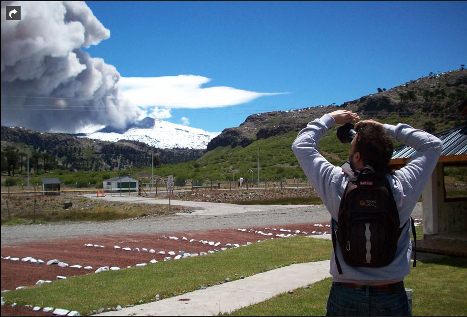 |
Figure 13. This photographer captured scenes of the rising ash plume from Copahue on 23 December 2012. The lighter cloud in the background is probably a non-volcanic, lenticular cloud, a feature often associated with mountains. Photograph from the Municipio Caviahue-Copahue courtesy of La Nación. |
Local newspapers reported that, on 23 December, ashfall and sulfur odors were limited to the proximal towns of Zapala (~150 km SE) and Cutral Co (~210 km SE). There were some reports of local citizens self-evacuating from the area due to anticipated ashfall. People within 15 km of the volcano and along drainages were warned about a potential increase in activity potentially including lahars. The municipalities of Villa La Angostura and Bariloche, located ~340 km S within Argentina, were not at risk during this event. In contrast, they had experienced heavy ashfall in 2011 due to Puyehue-Córdon Caulle's eruption.
The Buenos Aires Volcanic Ash Advisory Center (VAAC) reported at 1400 on 22 December 2012 that satellite images revealed a 110 km ash plume extending SE of Copahue; the plume was white and gray (figure 14). The plume persisted in satellite images during the next day, although its aerial extent later became restricted near the summit. By 24 December, the 22 December ash was only detected in an isolated area over the Atlantic Ocean.
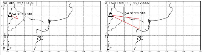 |
Figure 14. The Buenos Aires VAAC released maps for the observed (left) and forecasted (right) location of Copahue's ash plume from 22 December 2012. A 12 hour and 18 hour forecast was also released that extended the plume due E, reaching the Atlantic Ocean. Later images disclosed a detached plume out over the Atlantic Ocean (see text). Courtesy of Buenos Aires VAAC. |
VAAC reports indicated minor and possible ash emissions at the volcano on the following dates: 27, 28, and 30 December 2012; 2, 5, 9, and 10 January 2013; on 4 February; 28 and 29 March; on 12 April; on 15 November (possible ash was reported on 21 and 22 November). VAAC reports were also released intermittently during January-November 2013 due to gas emissions.
SERNAGEOMIN reduced the Alert Level from Red to Orange on 23 December 2012. The level was reduced again, on 28 December to Yellow, and was maintained until 5 January 2013 when seismicity increased (including three spasmodic tremor events). The webcamera also documented an increase in degassing that appeared to be gray and drifting E on 5 January; the Buenos Aires VAAC was able to track this minor ash plume. Alert Level Orange status continued until 17 January when it was decreased to Yellow.
The Alert Level fluctuated later in January (to and from Orange Alert) based on changing conditions which frequently included seismic swarms. One significant swarm, for example, occurred on 22 January.
Periodic incandescence was observed during February-May and SERNAGEOMIN reported small explosions of gas with minor ash on 7 and 15 May. On 19 May, OMI (Ozone Monitoring Instrument) detected elevated SO2 emissions within 300 m above the crater. During 20 and 22 May, satellite images detected gray-colored plume that drifted up to 100 km SE. On 23 May, incandescence was observed as well as an increase in SO2 flux as measured by the OMI satellite measurements; that activity triggered an increase in Alert Level to Orange.
Red Alert was announced one time in 2013 when, on 27 May, a seismic swarm began at a time of high RSAM measurements. An evacuation order was declared by SERNAGEOMIN that day for an area surrounding the volcano with a 25 km radius; they stated that the intensity and type of seismicity observed in the last few days and the deformation of the volcanic edifice suggested the rise of a magmatic body. Army trucks and buses were made available for the ~2,240 residents within that area, primarily those living in Alto Bío Bío. The swarm continued for several days into June. The Alert Level was reduced to Orange by 3 June. Local news sources reported that residents were authorized to begin returning to their homes on 6 June. The Alert Level was reduced to Yellow on 12 June and was maintained through the rest of 2013.
On 4 June 2013, the Hyperion sensor onboard the satellite EO-1 observed Copahue at 1333 UTC and a thermal anomaly was detected from the summit area of the volcano (figure 15). The calculated temperatures ranged from ~377 to ~647°C (personal communication, Ashley Davies, NASA Jet Propulsion Laboratory).
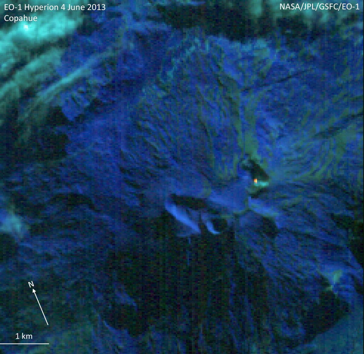 |
Figure 15. This satellite image captured a small point of elevated temperatures with the Hyperion sensor onboard EO-1; it was acquired on 4 June 2013 and composed of bands 2,1,3 (RGB). The image was obtained at a spatial resolution of 30 m per pixel. The north arrow and scale are approximate. Courtesy of Ashley Davies, NASA Jet Propulsion Laboratory. |
An overflight of Copahue's summit was conducted on 9 June by OVDAS-SERNAGEOMIN in order to make observations of the area as reconnaissance for future installations of three seismometers. A 200 m plume was visible rising from the crater although no lava or lava dome was visible within the crater. There were sulfurous gas odors and the observers also noted that there were no indications of lahar flows outside of the crater.
On 23 and 26 August SERNAGEOMIN reported that incandescence was observed by the local webcamera; a possible ash event occurred on 26 June. Elevated SO2 emissions were also detected by the Ozone Monitoring Instrument (OMI) on 23 August and during 5 days in September. Incandescence was reported during the last week of September.
On 16, 23, and 28 October, ash was observed by the local webcameras; the most energetic event occurred on 28 October. Elevated SO2 was detected by OMI on during 21, 26, and 27 October.
SERNAGEOMIN reported in their November report that INSAR data from NASA determined that deformation of the edifice continued at a rate of 3.9 cm/year which was considered less than values measured earlier in the year. Incandescence was notable on 13 November and minor ash was reported on 16, 17, 18, 21, and 30 November. Elevated SO2was detected by OMI on 29 November.
Small explosions were recorded on 10 December but ash was not confirmed. The local webcamera captured a plume that reached ~1,100 m above the crater. This event was accompanied by low-frequency seismicity.
MODVOLC Alerts 2012-2013: Elevated temperatures were detected by the MODIS sensors onboard the Aqua and Terra satellites during 2012-2013 (table 1). The MODVOLC system generated alerts on 11 days during the two years of unrest. During 2013, the alerts occurred in January and May on two separate days. While the local, SERNAGEOMIN webcamera recorded incandescence (particularly at night), the satellite remote sensing capabilities contended with cloudcover that frequently masked the area. For example, in January 2013 alone, there were 4 notable cases of nighttime incandescence (on 5, 8, 9, and 11 January).
Table 1. The MODVOLC system generated several thermal alerts during January 2012-May 2013. No additional alerts were generated during June-December 2013. Courtesy of HIGP.
| Date | Number of Pixels |
| 22 Dec 2012 | 5 |
| 23 Dec 2012 | 2 |
| 24 Dec 2012 | 2 |
| 26 Dec 2012 | 1 |
| 27 Dec 2012 | 4 |
| 28 Dec 2012 | 2 |
| 29 Dec 2012 | 2 |
| 30 Dec 2012 | 2 |
| 01 Jan 2013 | 1 |
| 03 Jan 2013 | 2 |
| 05 Jan 2013 | 3 |
| 10 Jan 2013 | 1 |
| 12 Jan 2013 | 1 |
| 09 May 2013 | 1 |
References. Agusto, M. 2011. Estudio Geoquímico de Fluidos Volcánicos-Hidrotermales del complejo volcánico Copahue-Caviahue, y su Aplicación a Tareas de Seguimiento. Tesis de Doctorado. 296 páginas. Facultad de Cs. Exactas y Naturales. Universidad de Buenos Aires.
Agusto, M., Tassi, F., Capaccioni, B., Rouwet, D., Caselli. A., Vaselli, O. (en preparación). Chemical and isotopic compositions of fumarolic discharges from magmatic-hydrothermal system of Copahue volcano (Argentina). A combined (inorganic and organic) geochemical approach to understanding the origin of the fluid discharges.
Agusto, M., Caselli, A., Tassi, F., dos Santos Afonso, M., Vaselli. O. 2012. (aceptado). Caracterización y seguimiento geoquímico de las aguas Ácidas del sistema volcÁn Copahue - río Agrio: posible aplicación para la identificación de precursores eruptivos. Revista de la Asociación Geológica Argentina. ISSN 0004-4822.
Agusto, M., Vélez, ML., Caselli, A., Euillades, P., Tassi, F., Capaccioni, B., Vaselli, O. 2012. Correlación entre anomalías térmicas, geoquímicas y procesos deflacionarios en el volcán Copahue. XIII Congreso Geológico Chileno. Antofagasta, 2012. Actas: 429-431.
Caselli, A.T., Agusto M.R. y Fazio A., 2005. Cambios térmicos y geoquímicos del lago cratérico del volcán Copahue (Neuquén): posibles variaciones cíclicas del sistema volcánico. XVI Congreso Geológico Argentino, La Plata. Actas I: 751-756.
Caselli, A., Vélez, M.L., Agusto, M.R., Bengoa, C.L. Euillades, P.A. Ibañez, J.M., 2009. Copahue volcano (Argentina): A relationship between ground deformation, seismic activity and geochemical changes. Ed. Bean, Braiden, Lockmer, Martini and O'Brien.The VOLUME project.VOLcanoes: Understanding subsurface mass movement. Printed by jaycee. ISBN: 978-1-905254-39-2, pp 309-318.
Caselli, A., M. Agusto, B. Capaccioni, F. Tassi, G. Chiodini y D. Tardani. 2012. Aumento térmico y composicional de las aguas cratéricas del VolcÁn Copahue registradas durante el año 2012 (Neuquen, Argentina). XIII Congreso Geológico Chileno. Antofagasta, 2012. Actas: 435-436.
Forte, P., C. Bengoa, A. Caselli. 2012. AnÁlisis preliminar de la actividad sísmica del complejo volcÁnico Copahue-Caviahue mediante técnicas de array. XIII Congreso Geológico Chileno. Antofagasta, 2012. Actas: 568-570.
Ibañez J. M., Del Pezzo E., Bengoa, C., Caselli, A.T., Badi, G.A y J. Almendros. 2008. Volcanic tremor associated with the geothermal activity of Copahue volcano, Southern Andes region, Argentina. Journal of Volcanology and Geothermal Research (Elsevier, ISSN:0377-0273) 174: 284-294.
Tassi, F., Caselli, A., Vaselli, O., Agusto, M., Capecchiacci. F., 2007.Downstream composition of acidic volcanic waters discharged from Copahue crater lake (Argentina): the chemical evolution of Rio Agrio watershed. Federazione Italiana della Scienze della Tierra- FIST. Italia.
Varekamp, J.C., Ouimette, A.; HermÁn, S., Bermúdez, A.; Delpino, D., 2001. Hydrothermal element fluxes from Copahue, Argentina: A "beehive" volcano in turmoil. Geology, 29 (11): 1059-1062.
Varekamp, J.C., Ouimette, A.P., Herman, S.W., Flynn, K.S., Bermudez, A., Delpino, D., 2009. Naturally acid waters from Copahue volcano, Argentina. Applied Geochemistry 24, 208-220.
Vélez, M.L., 2011. Análisis de la deformación asociada al comportamiento de sistemas volcÁnicos activos: Volcán Copahue. Tesis Doctoral. Facultad Ciencias Exactas y Naturales - Universidad de Buenos Aires, 154 p.
Velez, M. L., Euillades, P., Caselli, A., Blanco, M., Díaz, J.M., 2011, Deformation of Copahue volcano: Inversion of InSAR data using a genetic algorithm, Journal of Volcanology and Geothermal Research, 202: 117-126.
Geological Summary. Volcán Copahue is an elongated composite cone constructed along the Chile-Argentina border within the 6.5 x 8.5 km wide Trapa-Trapa caldera that formed between 0.6 and 0.4 million years ago near the NW margin of the 20 x 15 km Pliocene Caviahue (Del Agrio) caldera. The eastern summit crater, part of a 2-km-long, ENE-WSW line of nine craters, contains a briny, acidic 300-m-wide crater lake (also referred to as El Agrio or Del Agrio) and displays intense fumarolic activity. Acidic hot springs occur below the eastern outlet of the crater lake, contributing to the acidity of the Río Agrio, and another geothermal zone is located within Caviahue caldera about 7 km NE of the summit. Infrequent mild-to-moderate explosive eruptions have been recorded since the 18th century. Twentieth-century eruptions from the crater lake have ejected pyroclastic rocks and chilled liquid sulfur fragments.
Information Contacts: Observatorio Volcanológico de los Andes del Sur-Servicio Nacional de Geologia y Mineria (OVDAS-SERNAGEOMIN), Avda Sta María No. 0104, Santiago, Chile (URL: http://www.sernageomin.cl/); Alberto Caselli and Laura Vélez, Grupo de Estudio y Seguimiento de Volcanes Activos (GESVA), Departamento Ciencias Geológicas, FCE y N, Universidad de Buenos Aires, Buenos Aires , Argentina (URL: http://www.gesva.gl.fcen.uba.ar/); D. Pablo Groeber (UBA-CONICET), FCEyN - UBA (URL: http://www.ifibyne.fcen.uba.ar/new/); G. Badi, Departamento de Sismología e I. M., Facultad de Ciencias Astronómicas y Geofísicas, Universidad Nacional de La Plata (URL: http://www.fcaglp.unlp.edu.ar/ciencia-y-tecnica/); R. Daga, Laboratorio AnÁlisis por Activación Neutrónica (CAB-CNEA) - CONICET y C. Cotaro, y C. Ayala, Grupo de Caracterización de materiales (CAB-CNEA) (URL: http://www2.cab.cnea.gov.ar/); P. Euillades, L. Euillades, M. Blanco, and S. Balbarani, Instituto CEDIAC - Facultad de Ingeniería Universidad Nacional de Cuyo (URL: https://fing.uncu.edu.ar/); M. Araujo, Instituto Nacional de Prevención Sísmica (INPRES) (URL: http://www.inpres.gov.ar/); Buenos Aires Volcanic Ash Advisory Center (VAAC) (URL: http://www.smn.gov.ar/vaac/buenosaires/productos.php); Hawai'i Institute of Geophysics and Planetology (HIGP) MODVOLC Thermal Alerts System, School of Ocean and Earth Science and Technology (SOEST), Univ. of Hawai'i, 2525 Correa Road, Honolulu, HI 96822, USA (URL: http://modis.higp.hawaii.edu/); Simon Carn, NASA Global Sulfur Dioxide Monitoring, Aura/OMI (URL: https://so2.gsfc.nasa.gov/); La Nación, Buenos Aires, Argentina (URL: http://www.lanacion.com.ar/1539643-entro-en-erupcion-el-volcan-copahue); Dia a Dia, Buenoes Aires, Argentina (URL: http://www.diaadia.com.ar).