Report on Karymsky (Russia) — October 2013
Bulletin of the Global Volcanism Network, vol. 38, no. 10 (October 2013)
Managing Editor: Richard Wunderman.
Karymsky (Russia) Seismicity and ash plumes, September 2010-December 2013
Please cite this report as:
Global Volcanism Program, 2013. Report on Karymsky (Russia) (Wunderman, R., ed.). Bulletin of the Global Volcanism Network, 38:10. Smithsonian Institution. https://doi.org/10.5479/si.GVP.BGVN201310-300130
Karymsky
Russia
54.049°N, 159.443°E; summit elev. 1513 m
All times are local (unless otherwise noted)
This report summarizes activity at Karymsky from September 2010 to 31 December 2013. This period was characterized by frequent explosions with ash plumes, and persistent thermal anomalies. During this period, explosions catapulted ash to altitudes as high as 6.5 km (and possibly higher). According to Girina and others (2013), Karymsky has been in a state of explosive eruption since 1996.
The Kamchatka Volcanic Eruptions Response Team (KVERT) monitors the volcano by seismic instruments and by satellite. Occasionally, pilots and volcanologists observe the volcano visually; however, the volcano is frequently shrouded by clouds. KVERT does not directly observe ash plumes, but infers their presence and their maximum altitudes based upon seismic data, although sometimes satellite observations are used. Occasionally, plume altitudes and directions are provided by the Tokyo Volcanic Ash Advisory Center (VAAC), based on information from Yelizovo Airport (UHPP). The Aviation Color Code was Orange (the second highest) throughout the reporting period. This report is based on weekly KVERT online reports.
Figures 27 and 28 show Kamchatka and Karymsky in the context of both geography and representative aviation flight paths. Since Karymsky sits directly below a principal flight route and close to many others, tall ash plumes from Karymsky present an acute hazard to aircraft. More than 200 flights per day occurred over the North Pacific region at the end of 2007 (Neal and others, 2007). That translated to over 10,000 passengers and millions of dollars in cargo that flew across the North Pacific every day (Neal and others, 2007).
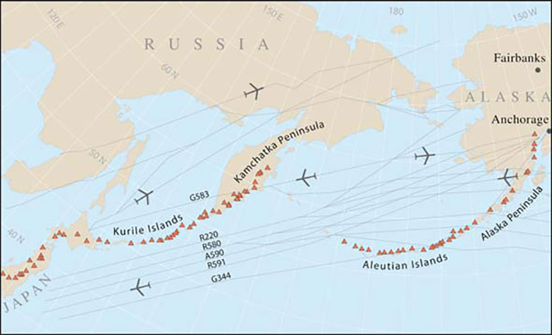 |
Figure 27. The Northern Pacific region showing major Holocene volcanoes in red and selected aeronautical flight paths across the Russian Far East and North Pacific. Karymsky lies nearly directly below the major, bidirectional flight path G583. Taken from Neal and others (2009). |
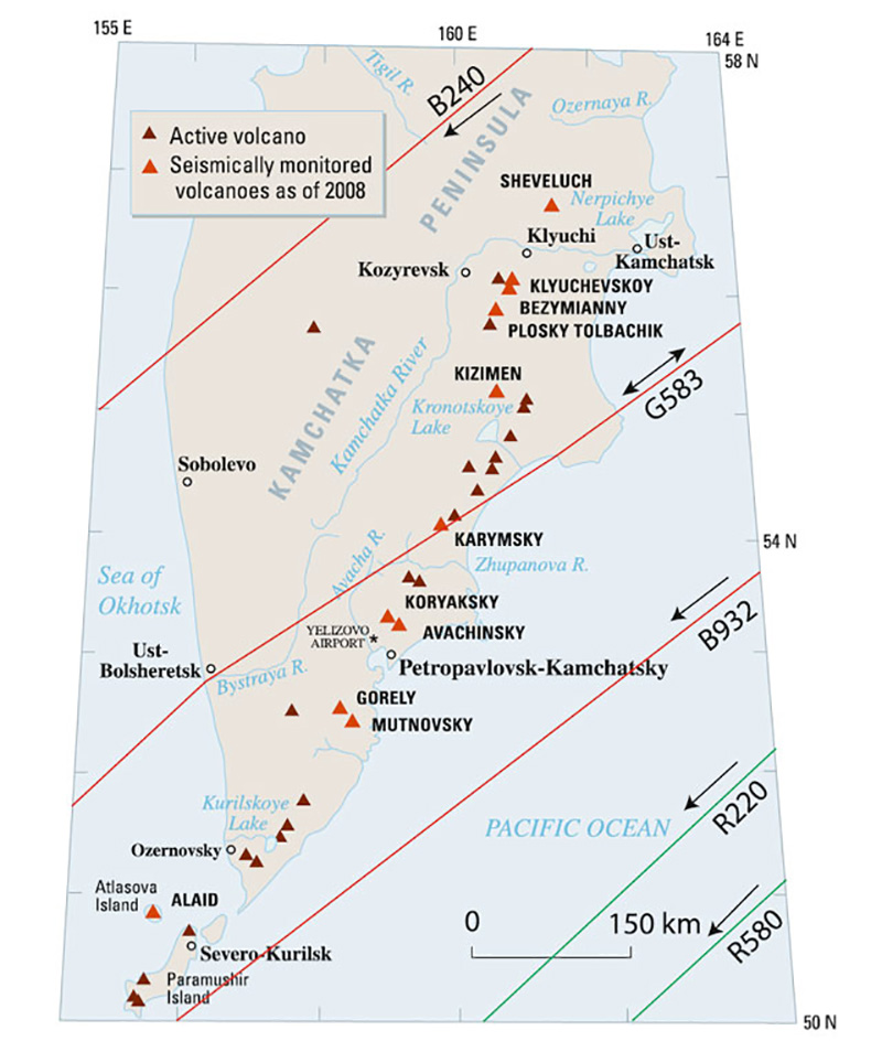 |
Figure 28. A smaller-scale map than the one above, centered on the Kamchataka Peninsula showing major Holocene volcanoes including Karymsky, with a more detailed view of flight routes (arrows show directions of travel). Seismically monitored volcanoes are distinguished from those unmonitored, with about 30 real-time seismometers available in the region as of 2008. Alaid volcano, just S of Kamchatka, is the subject of a separate report in this issue of the Bulletin. Taken from Neal and others (2009). |
September 2010-December 2012 activity. During September 2010-December 2010, KVERT weekly reports stated that seismic activity was at or above background levels. During January 2011-December 2012, most reports characterized the seismic activity as moderate. However, KVERT stated that activity was weak and moderate between 23 August-20 September 2012, during the week before 25 October 2012, and during all of December 2012. Activity was weak during the first week of July 2012.
According to KVERT, one or more ash explosions occurred weekly, and ash plumes rose to altitudes of 2-6.5 km, with most weekly values in the altitude range of 2.5-5 km. Explosive activity apparently weakened slightly during April and May 2012, with plume altitudes decreasing to 1.8-2.5 km, and apparently weakened further between mid-July and mid-August 2012, when KVERT did not report any ash plumes.
Figure 29 shows an image captured the MODIS instrument during May 2011. A plume is discernable to the edge of the image, ~140 km ESE. Radiating from the volcano is a pattern of recent ash fall deposits contrasting with broad snow cover.
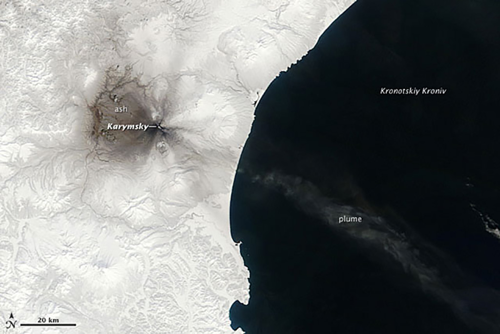 |
Figure 29. Satellite image of Karymsky acquired on 7 May 2011. Evidence of frequent eruptions is visible in this natural-color satellite image. Dark gray ash extends away from Karymsky's summit covering sectors of the volcano in radial patterns. A plume of ash extends to the SE, over Kronotskiy Kroniv (Kronotsky Gulf). The image was acquired by the Moderate Resolution Imaging Spectroradiometer (MODIS) aboard the Terra satellite. Courtesy of NASA's Earth Observatory (image by Jeff Schmaltz and original descriptive material by Robert Simmon). |
During mid-September 2012, ash plume altitudes reached 5.5-6 km, but had decreased to a more normal 3 km in December 2012. On 11 April 2012, instruments aboard the Terra satellite detected ash deposits about 15 km long on the E flank. According to the Tokyo VAAC, an ash plume rose to an altitude of 7.3 km and drifted N on 13 March 2011, and to an altitude of 5.5-11.9 km and drifted SW on 18 April 2011; the Tokyo VAAC reported several other ash plumes during the reporting period, but the two mentioned here represent the maximum plumes heights recorded during the reporting period.
KVERT reported Stombolian activity during October 2010. A thermal anomaly was reported every week during this period, although clouds often obscured satellite data.
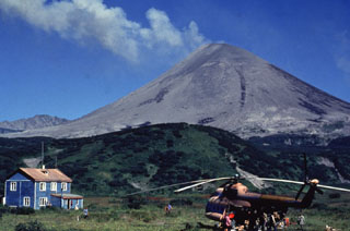
On 20 November 2010, volcanologists aboard a helicopter observed moderate gas-and-steam activity. Slopes near the summit were covered with ash. According to KVERT, volcanologists also visually observed weak gas-and-steam activity on 18 December 2012.
2013 activity. During January through March 2013, seismic activity fluctuated from weak to moderate. During April through mid-August, seismic activity was not recorded for technical reasons. From mid-August through the end of 2013, activity was moderate. When satellite data was included in 2013 KVERT weekly reports (6, 14 March; 11, 18 July; 5, 12, 19 September; 3 October), the volcano was either quiet or obscured by clouds.
KVERT reports from 10 October 2013 through at least 2 January 2014 stated that Strombolian and weak Vulcanian activity probably had occurred, because satellite data sometimes showed a bright thermal anomaly over the volcano along with ash plumes (figure 30). The reports did not mention this activity during earlier portions of the reporting period (September 2010-December 2013), except for mid-October 2010; however, because thermal anomalies persisted throughout the reporting period and ash plumes were common, we suspect that Strombolian and weak Vulcanian activity probably occurred often during this time.
During 2013, ash plumes seldom exceeded an altitude of 3.5 km. However, powerful ash explosions up to an altitude of 6 km were observed on 5 August by a helicopter crew and volcanologists on the flank of nearby Tolbachik volcano.
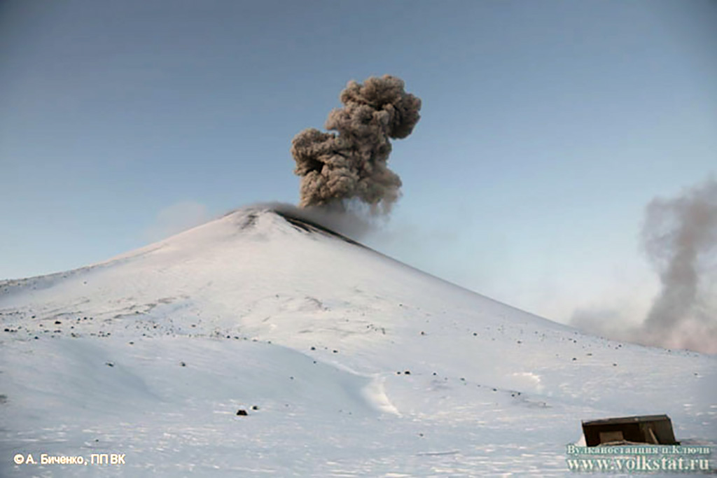 |
Figure 30. Photo of Karymsky on 30 November 2013 showing Vulcanian explosion with ash cloud billowing upward. Look direction unknown. Courtesy of Institute of Volcanology and Seismology FEB RAS, KVERT (with credit to Alexander Bichenko. NP VK). |
Lopez and others (2012) used "coincident measurements of infrasound, SO2, ash, and thermal radiation collected over a ten day period at Karymsky Volcano in August 2011 to characterize the observed activity and elucidate vent processes. The ultimate goal of this project is to enable different types of volcanic activity to be identified using only infrasound data, which would significantly improve our ability to continuously monitor remote volcanoes. Four types of activity were observed. Type 1 activity is characterized by discrete ash emissions occurring every 1- 5 minutes that either jet or roil out of the vent, by plumes from 500-1500 m (above vent) altitudes, and by impulsive infrasonic onsets. Type 2 activity is characterized by periodic pulses of gas emission, little or no ash, low altitude (100 - 200 m) plumes, and strong audible jetting or roaring. Type 3 activity is characterized by sustained emissions of ash and gas, with multiple pulses lasting from ~1-3 minutes, and by plumes from 300-1500 m. Type 4 activity is characterized by periods of relatively long duration (~30 minutes to >1 hour) quiescence, no visible plume and weak SO2 emissions at or near the detection limit, followed by an explosive, magmatic eruption, producing ash-rich plumes to >2,000 m, and centimeter to meter (or greater) sized pyroclastic bombs that roll down the flanks of the edifice. Eruption onset is accompanied by high-amplitude infrasound and occasionally visible shock-waves, indicating high vent overpressure."
The above meeting abstract ultimately led to the paper Lopez and others (2013). In the abstract for that work, the authors characterized the four types of activity as: (1) ash explosions, (2) pulsatory degassing, (3) gas jetting, and (4) explosive eruption.
Ongoing eruptions, often on a near daily basis, prevailed during January-March 2014, with thermal anomalies on satellite data, ash plumes hundreds of meters over the ~1.5 km summit's elevation. The plumes were visible in imagery for over 100 km downwind (often in the sector NE-E-SE).
References: Girina, O., Manevich, A., Melnikov, D., Nuzhdaev, A., Demyanchuk, Y., and Petrova, E., 2013, Explosive Eruptions of Kamchatkan Volcanoes in 2012 and Danger to Aviation, Geophysical Research Abstracts, Vol. 15, EGU General Assembly 2013 held 7-12 April, 2013 in Vienna, Austria, id. EGU2013-6760.
Lopez, T., Fee, D, and Prata, F., 2012, Characterization of volcanic activity using observations of infrasound, volcanic emissions, and thermal imagery at Karymsky Volcano, Kamchatka, Russia, Geophysical Research Abstracts, Vol. 14, EGU General Assembly 2012, held 22-27 April, 2012 in Vienna, Austria., p.13076.
Lopez, T., D. Fee, F. Prata, and J. Dehn, 2013, Characterization and interpretation of volcanic activity at Karymsky Volcano, Kamchatka, Russia, using observations of infrasound, volcanic emissions, and thermal imagery, Geochem. Geophys. Geosyst., 14, 5106-5127, doi:10.1002/2013GC004817
Neal C, Girina O, Senyukov S, Rybin A, Osiensky J, Izbekov P, Ferguson G, 2009, Russian eruption warning systems for aviation. Natural Hazards, 51(2), p. 245-262
Neal, C, Girina, O, Senyukov, S, Rybin, A, Osiensky, J, Hall, T, Nelson, K, and Izbekov, P, 2007, Eruption Warning Systems for Aviation in Russia: A 2007 Status Report, World Meteorological Organization (WMO), in close collaboration with the International Civil Aviation Organization (ICAO) and the Civil Aviation Authority Of New Zealand, paper at the Fourth International Workshop On Volcanic Ash, Rotorua, New Zealand, 26-30 March 2007 [VAWS/4 WP/03-01] (URL: http://www.caem.wmo.int/moodle/file.php?file=/1/VWS/6_VAWS4WP0301_1_.pdf)
Geological Summary. Karymsky, the most active volcano of Kamchatka's eastern volcanic zone, is a symmetrical stratovolcano constructed within a 5-km-wide caldera that formed during the early Holocene. The caldera cuts the south side of the Pleistocene Dvor volcano and is located outside the north margin of the large mid-Pleistocene Polovinka caldera, which contains the smaller Akademia Nauk and Odnoboky calderas. Most seismicity preceding Karymsky eruptions originated beneath Akademia Nauk caldera, located immediately south. The caldera enclosing Karymsky formed about 7600-7700 radiocarbon years ago; construction of the stratovolcano began about 2000 years later. The latest eruptive period began about 500 years ago, following a 2300-year quiescence. Much of the cone is mantled by lava flows less than 200 years old. Historical eruptions have been vulcanian or vulcanian-strombolian with moderate explosive activity and occasional lava flows from the summit crater.
Information Contacts: Kamchatka Volcanic Eruptions Response Team (KVERT), Far East Division, Russian Academy of Sciences, 9 Piip Blvd., Petropavlovsk-Kamchatsky, 683006, Russia (URL: http://www.kscnet.ru/ivs/); Tokyo Volcanic Ash Advisory Center (VAAC), Tokyo, Japan (URL: http://ds.data.jma.go.jp/svd/vaac/data/); Kamchatka Branch of Geophysical Survey of RAS (KB GS RAS) (URL: http://www.emsd.ru/); and Jeff Schmaltz and Robert Simmon, NASA Earth Observatory (URL: http://earthobservatory.nasa.gov).