Report on Merapi (Indonesia) — October 2014

Bulletin of the Global Volcanism Network, vol. 39, no. 10 (October 2014)
Managing Editor: Richard Wunderman.
Merapi (Indonesia) During June 2011 to December 2014, several eruptions and elevated seismicity
Please cite this report as:
Global Volcanism Program, 2014. Report on Merapi (Indonesia) (Wunderman, R., ed.). Bulletin of the Global Volcanism Network, 39:10. Smithsonian Institution. https://doi.org/10.5479/si.GVP.BGVN201410-263250
Merapi
Indonesia
7.54°S, 110.446°E; summit elev. 2910 m
All times are local (unless otherwise noted)
This report details activity and monitoring at Merapi from 13 June 2011 through December 2014.
The last major eruption at Merapi was in 2010 as discussed in the previous two reports. As noted in BGVN 36:01 (covering 26 October 2010 to January 2011), Merapi began to erupt on 26 October 2010 and continued erupting throughout the interval, causing ~400 fatalities. BGVN 36:05 (26 October 2010 to 12 June 2011) further discussed this eruption detailing new dome growth and how lahars damaged infrastructure.
During the current reporting interval (13 June 2011 through December 2014), Merapi erupted regularly amid elevated seismicity. This report chiefly derives from three sources: (1) Balai Penyelidikan dan Pengembangan Teknologi Kegunungapian (BPPTK), (2) Pusat Vulkanologi dan Mitigasi Bencana Geologi (PVMBG; here referenced as CVGHM which stands for Center for Volcanology and Geological Hazard Mitigation), and (3) the Darwin Volcanic Ash Advisory Center (VAAC).
Activity during 2011.The hazard status for Merapi from 13 June 2011 onwards was Alert, Level II (on a scale of I–IV), before it decreased during 12–18 September 2011 and remained at Normal, Level I. Several minor avalanches occurred, with noted incidents on 2, 4, 6, 7, 14, and 25 July; 2, 7, and 15 August; and 4 and 8 September. Merapi also released several plumes, most of which consisted of white, thin or thin-to-thick clouds that rose to a maximum of only a few hundred meters above the summit (table 21).
Table 21. From 13 June to 31 December 2011, the plumes released by Merapi were generally described as thin or thin-to-thick and white in color. The only exception was apparent puffing associated with the plume on 10 July 2011, which lasted ~3 hours. Courtesy of BPPTK weekly reports from 2011.
| Date | Time (Local Time) | Max. height above the crater(m) |
| 19 Jun 2011 | 2100 | 200 |
| 03 Jul 2011 | 2015 | 600 |
| 04 Jul 2011 | 2043 | 600 |
| 10 Jul 2011 | 2100-2400 | 200 |
| 16 Jul 2011 | 2115 | 400 |
| 18 Jul 2011 | 1750 | 350 |
| 25 Jul 2011 | 1510 | 400 |
| 07 Aug 2011 | 2150 | 400 |
| 10 Aug 2011 | 2028 | 600 |
| 18 Aug 2011 | 2015 | 200 |
| 03 Sep 2011 | 3002 | 350 |
| 08 Sep 2011 | 1950 | 100 |
| 16 Sep 2011 | 1650 | 200 |
| 10 Oct 2011 | 1805 | 150 |
| 23 Oct 2011 | 1740 | 125 |
| 26 Oct 2011 | 1840 | 100 |
| 06 Nov 2011 | 1456 | 400 |
| 09 Nov 2011 | 1720 | 400 |
| 02 Dec 2011 | 1740 | 150 |
| 05 Dec 2011 | 1700 | 200 |
| 14 Dec 2011 | 1929 | 900 |
| 31 Dec 2011 | 2110 | 90 |
The non-tremor seismicity at Merapi in 2011 (figure 54) was categorized into four types of earthquakes, each of which had different patterns on the time-series plots. The seismicity was also described in terms of Real-time Seismic Amplitude Measurement (RSAM), (not shown here). In 2011, avalanche earthquakes and multiphase earthquakes dominated the record.
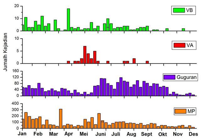 |
Figure 54. Number of earthquakes ("Jumlah Kejadian" in Indonesian) recorded at Merapi for 2011 with shallow volcanic (VB, green), deep volcanic (VA, red), avalanche ("Guguran," purple), and multiphase (MP, orange) earthquakes. The terms shallow and deep were not quantified. Note that the y-axis scales vary such that the most numerous earthquakes were MP and avalanche, and the least numerous were VB and VA. Courtesy of BPPTK (taken from their 2–8 January 2012 weekly report). |
A key means of measuring changes in linear length at Merapi consisted of surveys employing Electronic Distance Measurement (EDM) instruments (figure 55). The instruments computed the distance from several reflectors positioned on Merapi's slopes to fixed points at surrounding observatory posts. Figure 56 (below) provides the location of the posts and reflectors mentioned. Length changes were generally in the range of a few centimeters.
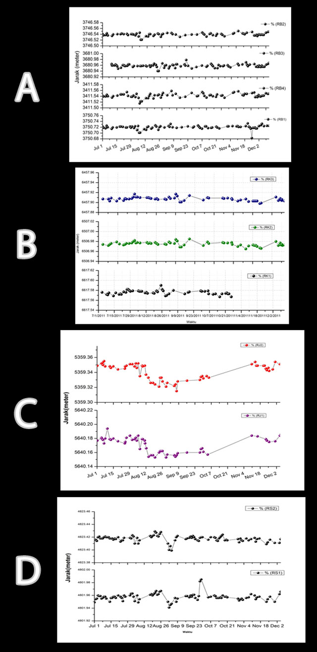 |
Figure 55. EDM linear length at Merapi in 2011, based on the distances from specified reflectors to various fixed locations. "Jarak" signifies distance (in meters). (A) 1 July to 30 December, recorded by Post Babadan. (B) 1 July to 9 December, recorded by Post Kaliurang. (C) 1 July to 5 December, recorded by Post Jrakah. The EDM linear lengths between the Post and both reflectors were broadly similar. (D) 1 July to 5 December, recorded by Post Selo. Courtesy of BPPTK (26 December 2011–1 January 2012 report). |
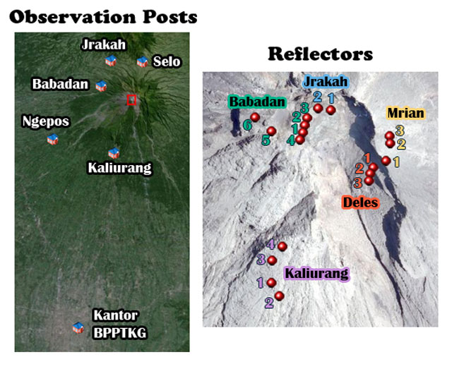 |
Figure 56. Images highlighting the locations of Merapi's observation posts (left) and reflectors (right). The right image is a zoomed-in version of the summit area (approximate red rectangle on the left image). To provide scales, the distance (in the image at left) from the summit to Kantor BPPTKG is ~30 km and the distance (in the image at right) from Jrakah 1 to Deles 3 is ~300 m. Courtesy of BPPTK (page titled Aktivitas Merapi), image captioned by Bulletin editors. |
Activity during 2012. A thin, white plume rose to a maximum of 150 m above the crater at 1910 on 6 January, and storms and heavy clouds covered Merapi's summit. On 9 January at an unstated time, a photo from CCTV Deles (discussed by BPPTK) showed Merapi amid clear weather with a white billowing cloud rising from the crater area. A few days later, at 1835 on 15 January, Merapi ejected a thin, white plume, rising to a maximum of 100 m above the summit, heading W. Thin, white plumes were also observed above the crater to 50 m, heading E on 1 February at 1720; to 500 m at 1745 on 11 February; and to 400 m at 1800 on 13 February. During 30 July to 5 August 2012, BPPTK referred to thick, white plumes drifting from the volcano. One plume reached a maximum of 600 m above the crater at an unstated date around this time. For the intervals in 2012 discussed above, the hazard status remained constantly at Normal (I). Furthermore, during 2012, the BPPTK recorded the seismicity (figure 57) and the EDM linear length (figure 58).
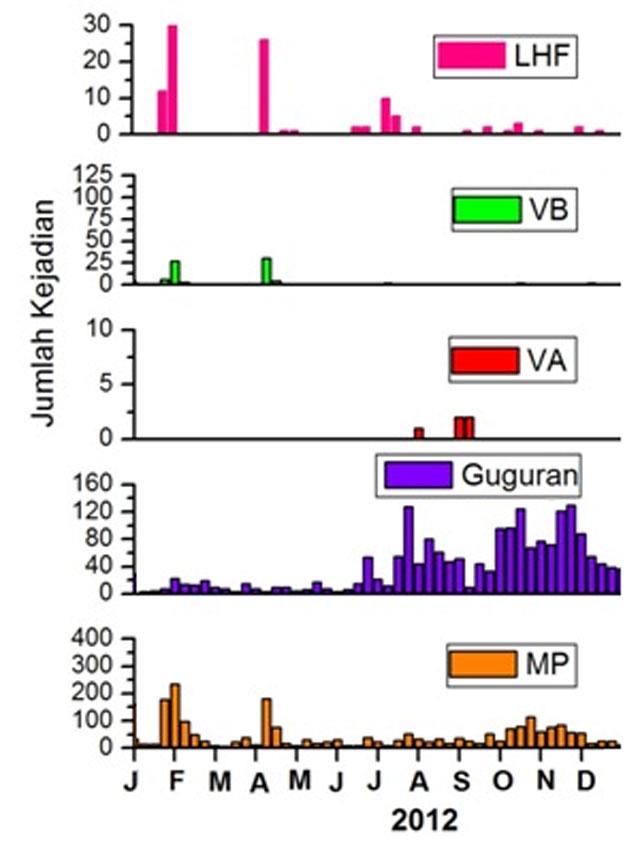 |
Figure 57. Number of earthquakes ("Jumlah Kejadian" in Indonesian) at Merapi for 2012 with low-high frequency (LHF, pink), shallow volcanic (VB, green), deep volcanic (VA, red), avalanche ("Guguran," purple), and multiphase (MP, orange) earthquakes. The numbers/peaks for each type of earthquake did not follow the same pattern. Note that the numbered scales on the left side vary. Courtesy of BPPTK (28 January–3 February 2013 report). |
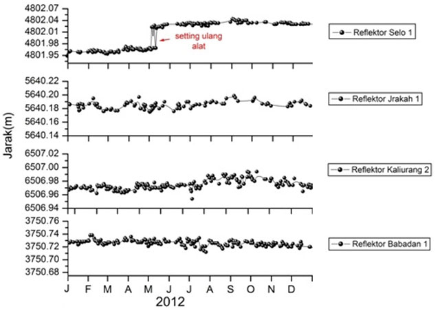 |
Figure 58. Merapi's EDM linear length in 2012, based on the distances from reflectors to various fixed locations. "Jarak" signifies distance (in meters). The measurements were recorded by Selo, Jrakah, Kaliurang, and Babadan stations (top to bottom). The sudden shift in the trend and the words "Setting ulang alat" (red words on the topmost graph) refer to technicians resetting the scale at that time (the instrument remained stable). Courtesy of BPPTK (28 January–3 February 2013 report). |
Activity during 2013. A thick plume blew W and reached a maximum of 450 m above the crater at 1750 on 3 February. The hazard status was at Normal (I).
On 22 July at 0415, BPPTK observed an ash eruption with brown-to-black color, reaching 1 km above the crater. A roar was heard within a radius of 6–7 km around Merapi, and ash fell to the SE, S, and SW. The hazard status remained at Normal (I); the Aviation Color Code was at Orange. According to a news article (Yahya, 2013), the eruption caused hundreds to temporarily evacuate; they returned to their homes later the same day. On 29 October 2013, BPPTK observed a white, thin-to-thick plume that reached 150 m above the summit, heading W.
On 18 November 2013, Merapi erupted. A news article in the Jakarta Post discussed the event extensively quoting BPPTK staff (Muryanto and Ayuningtyas, 2013). The article said that the eruption began at 0453 LT forming a plume that rose to 2 km above the crater. Ash fell until about 1000 that day, with noticeable amounts found up to 60 km to the E. The news report also noted that ~600 families "in Kalitengah Lor, Kalitengah Kidul and Srune hamlets, and in Glagaharjo village, Sleman regency, Yogyakarta, had immediately gathered to be evacuated" and that "villagers in Turgo village, Turi district, Sleman, located on the western flank of Mount Merapi, also fled their homes, [returning] a few hours later as the situation returned to normal." The eruption followed an M 4.7 tectonic earthquake detected in Ciamis, West Java earlier that day and was more powerful than a previous eruption on 22 July 2013 (Muryanto and Ayuningtyas, 2013).
Based on a Darwin VAAC report at 2025 LT on the same day (18 Nov), the eruption formed a plume that reached ~12.2 km altitude. The Aviation Color Code was increased to Red. By 2104 on the 18th, VAAC satellite analysis no longer detected the high altitude volcanic plume, but the VAAC reported a lower plume at ~4.6 km altitude. At 0300 on 19 November, the low level plume had extended to ~46 km E. However, by 0735, the plume had completely dissipated, and the Aviation Color Code returned to Orange.
BPPTK noted the seismicity (figure 59), the EDM linear length (figure 60), and the tilt (figure 61). In 2013, seismicity was dominated by avalanche earthquakes (figure 59). The only major change in linear length was the distance to Kaliurang 2 which had a gradual upward trend for most of the year, before a comparatively rapid downward trend in mid-October (figure 60). The two tiltmeter records showed broad consistency, with mild increases in the middle to late part of the year that reverted near to the original tilt (figure 61). The temperature graph had a broad peak in August 2013 that could account for some of the increase in tilt, but the BPPTK report did not discuss this in any detail. (For the location of the tiltmeter stations mentioned, see figure 62.)
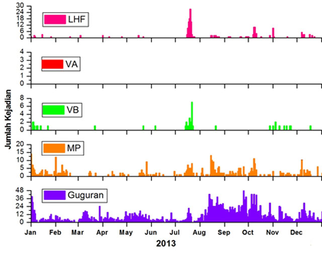 |
Figure 59. Number of earthquakes ("Jumlah Kejadian" in Indonesian) in 2013 at Merapi for low-to-high frequency (LHF, pink), deep volcanic (VA, red), shallow volcanic (VB, green), multiphase (MP, orange), and avalanche ("Guguran," purple) earthquakes. Y-axis scales vary. Courtesy of BPPTK (17–23 January 2014 report). |
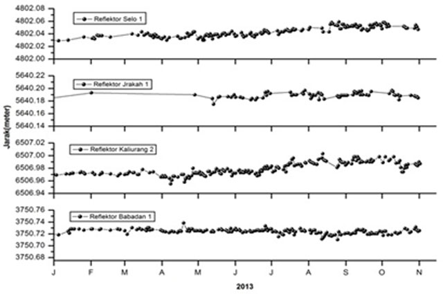 |
Figure 60. Merapi EDM linear length recorded during 2013, based on the distances from reflectors to various fixed locations. "Jarak" signifies distance (in meters). The measurements were recorded using reflectors Selo 1, Jrakah 1, Kaliurang 2, and Babadan 1 (top to bottom). Courtesy of BPPTK (25–31 October 2013 report). |
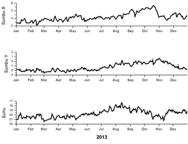 |
Figure 61. Tilt recorded at Merapi's station Plawangan. Y-axis units for the upper two tilt plots are microradians (arbitrary values). "Sumbu X" refers to tilt along a line running E-W and "Sumbu Y" to tilt along a line running N-S. The bottom plot is "Suhu" or temperature in degrees Celsius, which CVGHM noted may have a strong impact on the tilt measurements. Courtesy of BPPTK (17–23 January 2014 report). |
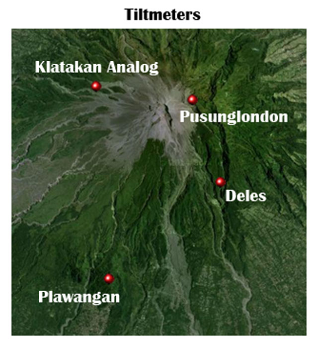 |
Figure 62. The location of the tiltmeter stations. To provide a scale, the distance from Klatakan Analog to Pusunglondon is ~0.9 km. Courtesy of BPPTK (Aktivitas Merapi). |
Activity during 2014. BPPTK noted that on 17 January at 1615, a white plume rose to 50 m above the summit, heading E.
At 1854 LT on 10 March 2014, Merapi erupted forming an ash plume that blew W. The event was captured on an automated closed-circuit video (CCTV Pasarbubar) and was followed by two more blasts within a minute (the first at 1855). At 1908, BPPTK noted a volcanic earthquake (with a maximum amplitude of 20 cm). Another video monitor (CCTV Bubar) recorded brown eruptive columns that rose straight up, reaching up to ~1.5 km above the summit. During 1925 to 1930, the eruption gradually stopped. Around this time, ash fell on several villages including Umbulharjo, Kepuharjo, Sidorejo, and Balerante, areas located ~6–7 km to the S of Merapi.
During 14-20 March 2014, thick gas plumes rose to ~600 m above the summit. On 17 March, the BPPTK recorded one such event at 0530.
On 27 March 2014, an eruption lasted from 1312 to 1316 LT. The VAAC detected volcanic ash to ~9.8 km altitude, using multi-spectral MTSAT-2 imagery, and the Aviation Color Code was raised to Red. A pilot reported that the "large ash cloud [was] moving NW." Darwin VAAC received a SACS SO2 alert at 2150 for the plume, and atmospheric SO2 gas was detected SE of Merapi. By 2232, the volcanic ash appeared to be dissipating; the advisory was terminated at 0830 on 28 March.
The 27 March eruption was the subject of a Jakarta Post news article by Muryanto and Ayuningtyas (2014), who indicated that ash fell in the Kemalang and Balerante Klaten regency and that it was 1 mm thick in some areas. The article also noted an M 5.4 tectonic earthquake that struck ~115 km SE of Malang regency, East Java on 23 March. The ash discharge had apparently been occurring regularly since the 2010 eruption but authorities had not taken this as a sign of an escalation in activity, and they urged locals to remain calm. However, according to the article, Sukiman, a resident of the nearby Deles district, said villagers responded to half an hour of ash falling by hitting "kentongan [bamboo drums] to warn others of the danger."
On 15 April, BPPTK reported that a thick white plume rose to a maximum of 300 m above the summit.
Several tectonic earthquakes occurred in April 2014. On 18 April at 2033, BPPTK recorded tectonic earthquakes 151 km SW of Merapi at a depth of 10 km. On 19 April, four more tectonic earthquakes occurred between 0800 and 2000, and an earthquake lasting 20 minutes was recorded at 0421 from a station on the peak of Merapi. On 20 April from 0426 to 0440, rumbling could be heard within a radius of 8 km around the volcano.
The BPPTK reported that on 20 April at 1600, an ash plume traveled W towards the village of Sewukan, amid foggy conditions. The associated eruption was followed by a widely heard roar and a later thin-to-thick plume rose to 400 m above the summit at 1800. The activity ultimately led to ashfall in Sewukan and in sectors to the SE, S, and SW, up to 15 km away from Merapi's summit.
The ash from this eruption was also detected by Darwin VAAC, who stated that the ash plume rose to ~10.7 km and extended ~260 km W to NW. The ash was difficult to distinguish from meteorological clouds, and at 1004 LT on 21 April, the VAAC terminated the advisory. In a news article, Minggu (2014) added further details on the eruption omitted here.
The BPPTK conducted a field expedition on 22 April to Merapi's crater. The expedition found that the eruption on 20 April had changed the summit crater morphology (figure 63). The slit that cut through the lava dome trending NE had widened by 70 m to the W, and reddish material that the team judged as indicative of oxidation was visible around the center of the lava dome. They also found new eruptive products along the crater's W side and evidence of new growth at the lava dome.
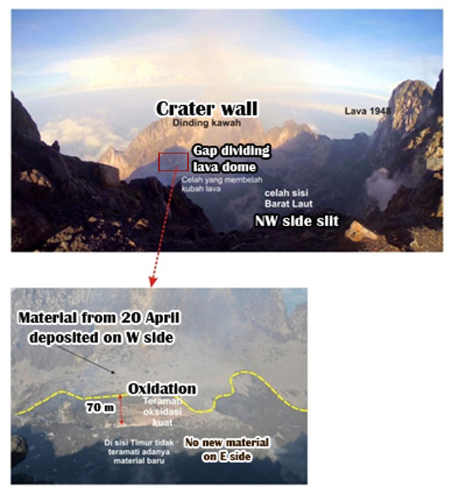 |
Figure 63. Field observations made on 22 April 2014 of Merapi's crater, assessing the aftermath of the 20 April eruption. (Top) View through the NW slit in the dome's crater. The crater wall appears in the background. (Bottom) Blowup of region depicted by base of red arrow. A wall in the summit crater area shifted W by ~70 m. New deposits were found in the area on the far side of the yellow dashed line. Courtesy of BPPTK (18–24 April 2014 report), image re-captioned in English by Bulletin editors. |
The BPPTK reported that monitoring outposts heard as many as 47 thumping sounds between 25 April and 1 May 2014, 20 sounds between 2 and 8 May, and 22 sounds between 9 and 15 May. On 25 April at 0740, a white, fumarolic plume rose to a maximum of 450 m above the summit, heading W, and the hazard status was raised to Alert (II). White, thin-to-thick plumes rose above the summit to 650 m on 2 May at 0700; to 350 m on 12 May at 0606; to 450 m on 22 May at 1924; to 300 m, heading W, on 27 May at 1854; and to 400 m on 31 May at 2010. The hazard status was lowered to Normal (I) during 21–27 May.
On 4 July 2014 at 1754, BPPTK observed thin-to-thick white plumes rising to 450 m above the summit.
On 10 September at 2008, thin, white plumes rose to 200 m above the summit, according to BPPTK.
During 10 to 16 October, Merapi released a thin white plume to ~200 m above the summit. The Darwin VAAC noted that small rock avalanches extended for ~1 km.
For 2014, BPPTK noted the seismicity (figure 64), EDM linear length (figure 65), and tilt (figure 66).
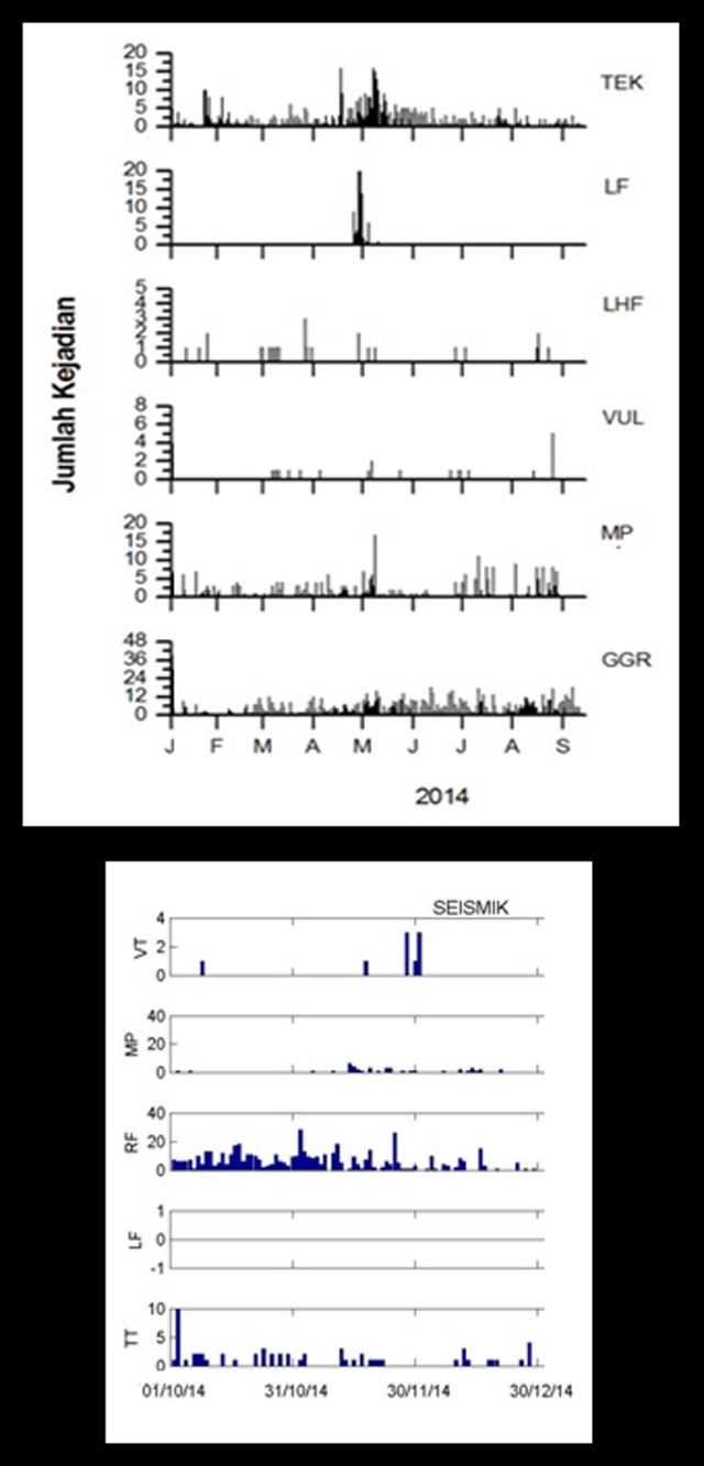 |
Figure 64. Number of earthquakes ("Jumlah Kejadian" in Indonesian) registered at Merapi for 2014. Note that the y-axis scales vary. (Top) Chart covers from January to September 2014 and consists of earthquakes: volcano-tectonic (TEK), low frequency (LF), low-to-high frequency (LHF), volcanic (VUL), multiphase (MP), and avalanche (GGR). (Bottom) Chart covers from October to December 2014 and consists of tremors (VT) and earthquakes: multiphase (MP), rock fall signals (RF), and tectonic (TT). Courtesy of BPPTK (5–11 September 2014 and 20–26 March 2015 reports). |
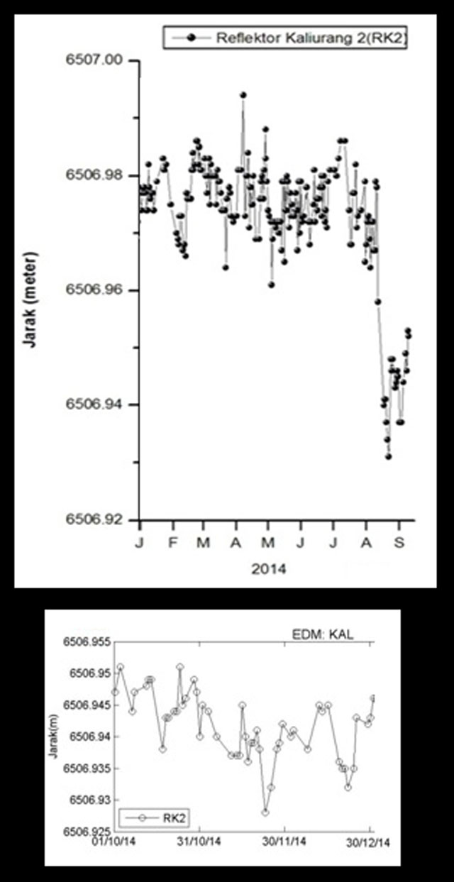 |
Figure 65. Merapi EDM linear length in 2014, based on the distances from reflectors to Post Kaliurang. "Jarak" signifies distance (in meters). The top chart covers from January to September and the bottom from October to December. (Date format for bottom is day/month/year.) Courtesy of BPPTK (5-11 September 2014 and 20–26 March 2015 reports). |
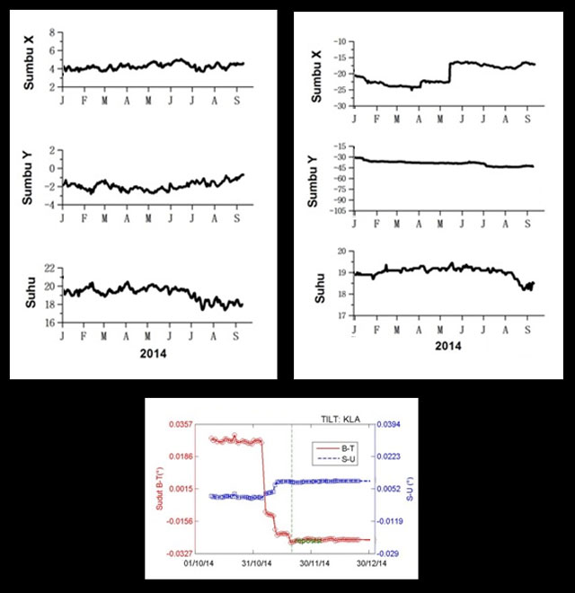 |
Figure 66. Tilt registered at Merapi in 2014 (y-axis/microradians with arbitrary values). (Top) January to September 2014, based on recordings made at stations Plawangan (left) and Babadan (right). "Sumbu X" portrays tilt along an E-W direction and "Sumbu Y", tilt along a N-S direction. The last plot ("Suhu") in each of these two cases shows the temperature in degrees Celsius. (Bottom) October to December, based on recordings made by station Klatakan Analog. The red line represents (tangential) tilt in an E-W direction ("Sudut B-T"). The blue line represents (radial) tilt in a N-S direction ("S-U"). The sudden changes in the red and blue lines were caused by repositioning. Courtesy of BPPTK (5–11 September 2014 and 20–26 March 2015 reports). |
Background. Several detailed maps of Merapi have been published by various sources. Handisantono and others (2002) contains a topographic hazard map of Merapi. The map includes the location of several villages mentioned in this report, as wells as rivers and other geological landmarks. BNPB also published a map of Merapi (figure 67). The map highlights the location of the W/SW/S-flank drainage systems, which have the potential to funnel lahars to local infrastructure such as bridges and into inhabited areas.
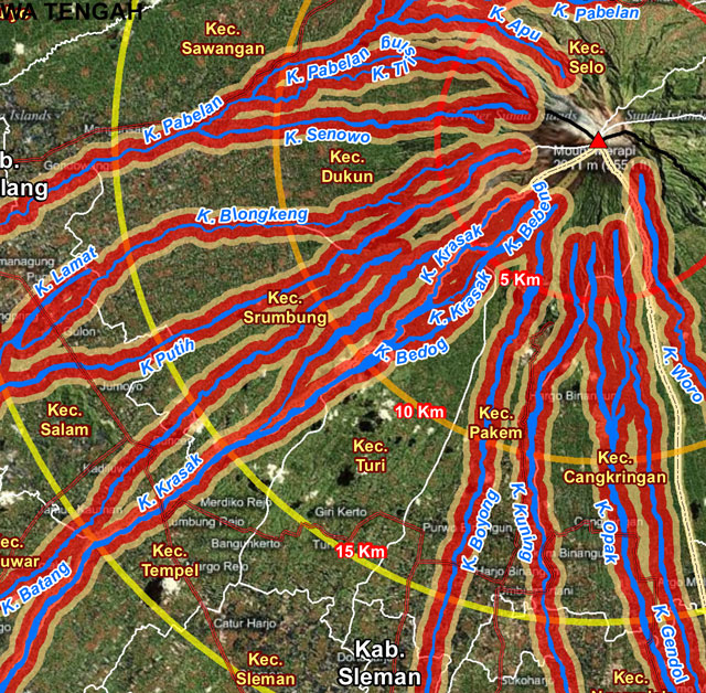 |
Figure 67. A section of a map of Merapi detailing lahars and related drainage systems (blue lines). The bounding color areas around the lahars represent associated hazard zones with risk levels ranging from yellow to red (least risk to most). Portions of concentric red, orange, and yellow circles mark the radial distance from Merapi's summit in kilometers. Courtesy of BNPB (date unknown). |
A detailed analysis of Merapi's history and periods of activity is documented by CVGHM (2014). The ongoing magmatism and volcanism at Merapi are considered consistent with documented copper, zinc, and lead enrichment as well as zonation there (Nadeau and others, 2013).
References.
Badan Nasional Penanggulangan Bencana (BNPB), date unknown, Peta Zonasi Ancaman Banjir Laha Dingin, Relief Web (URL: http://reliefweb.int/sites/reliefweb.int/files/resources/E0676C85D7612CE1852578340054FD68-map.pdf) [accessed in April 2015]
CVGHM, 2014, G. Merapi, Jawa Tengah, 03 June 2014, Center for Volcanology and Geological Hazard Mitigation (URL: http://www.vsi.esdm.go.id/index.php/gunungapi/data-dasar-gunungapi/542-g-merapi) [accessed in April 2015]
Hadisantono, R.D., Andreastuti, M.CH.S.D., Abdurachman, E.K., Sayudi, D.S., Nurnusanto, I., Martono, A., Sumpena, A.D., Muzani, M., 2002, Peta Kawasan Rawan Bencana Gunungapi Merapi, Jawa Tengah Dan Daerah Istimewa Yogayakarta (Volcanic Hazard Map of Merapi Volcano, Central Java and Yogyakarta Special Province), Center for Volcanology and Geological Hazard Mitigation (URL: http://www.vsi.esdm.go.id/galeri/index.php/Peta-Kawasan-Rawan-Bencana-Gunungapi-01/Wilayah-Jawa/KRB-G_-Merapi) [accessed in April 2015]
Minggu, 2014, Mt. Merapi rumbles spewing volcanic material to nearby areas, 20 April 2014, Antara News (URL: http://www.antaranews.com/en/news/93713/mt-merapi-rumbles-spewing-volcanic-material-to-nearby-areas) [accessed in April 2015]
Muryanto, B., Ayuningtyas, K., 2013, Hundreds of villagers flee Mount Merapi eruptions, 19 November 2013, The Jakarta Post (URL: www.thejakartapost.com/news/2013/11/19/hundreds-villagers-flee-mount-merapi-eruptions.html) [accessed in April 2015]
Muryanto, B., Ayuningtyas, K., 2014, Mount Merapi spews sulfuric gas, ash, 11 March 2014, The Jakarta Post (URL: www.thejakartapost.com/news/2014/03/11/mt-merapi-spews-sulfuric-gas-ash.html) [accessed in April 2015]
Nadeau, O., Stix, J., Williams-Jones, A.E., 2013, The behavior of Cu, Zn and Pb during magmatic–hydrothermal activity at Merapi volcano, Indonesia, 29 March 2013, Chemical Geology Volume 342 (URL: www.sciencedirect.com/science/article/pii/S0009254113000466)
Yahya, A., 2013, Mount Merapi Status Remains Normal Despite Weak Eruptions, 22 July 2013, Bernama (URL: http://www.bernama.com/bernama/v7/ge/newsgeneral.php?id=965338) [accessed in April 2015]
Geological Summary. Merapi, one of Indonesia's most active volcanoes, lies in one of the world's most densely populated areas and dominates the landscape immediately north of the major city of Yogyakarta. It is the youngest and southernmost of a volcanic chain extending NNW to Ungaran volcano. Growth of Old Merapi during the Pleistocene ended with major edifice collapse perhaps about 2,000 years ago, leaving a large arcuate scarp cutting the eroded older Batulawang volcano. Subsequent growth of the steep-sided Young Merapi edifice, its upper part unvegetated due to frequent activity, began SW of the earlier collapse scarp. Pyroclastic flows and lahars accompanying growth and collapse of the steep-sided active summit lava dome have devastated cultivated lands on the western-to-southern flanks and caused many fatalities.
Information Contacts: Balai Penyelidikan dan Pengembangan Teknologi Kegunungapian (BPPTK), Pusat Vulkanologi dan Mitigasi Bencana Geologi (PVMBG) (URL: http://merapi.bgl.esdm.go.id/); Darwin Volcanic Ash Advisory Centre (VAAC) (URL: http://www.bom.gov.au/info/vaac/); and Center for Volcanology and Geological Hazard Mitigation (CVGHM, Pusat Vulkanologi dan Mitigasi Bencana Geologi), Badan Geologi, Kementerian Energi dan Sumber Daya Mineral (ESDM), Yogyakarta 55166, Indonesia (URL: http://www.vsi.esdm.go.id/).