Report on Masaya (Nicaragua) — October 2015

Bulletin of the Global Volcanism Network, vol. 40, no. 10 (October 2015)
Managing Editor: Edward Venzke.
Edited by A. Elizabeth Crafford.
Masaya (Nicaragua) Ash explosions during April-June 2012; brief crater incandescence in April 2013
Please cite this report as:
Global Volcanism Program, 2015. Report on Masaya (Nicaragua) (Crafford, A.E., and Venzke, E., eds.). Bulletin of the Global Volcanism Network, 40:10. Smithsonian Institution. https://doi.org/10.5479/si.GVP.BGVN201510-344100
Masaya
Nicaragua
11.9844°N, 86.1688°W; summit elev. 594 m
All times are local (unless otherwise noted)
Explosions from Santiago crater at Masaya volcano during 30 April-17 May ejected ash and bombs as large as 60 cm (BGVN 37:06). INETER (Instituto Nicareguense de Estudios Territoriales) noted that significant eruptive activity tapered off in mid-May, with two small explosions observed during fieldwork on 17 May. Officials from Parque Nacional Volcán Masaya (PNVM) conducted daily monitoring of the during much of June, reporting gray and white gas plumes rising generally 200-300 m above the crater, and occasionally as high as 600 m, with variable wind directions. The last possible ash emissions were reported by Park Officials on 7-8 June 2012, when gray and white plumes rose 300 m above the crater. On 15 June, INETER presented an interagency report recommending that PNVM be reopened to the public on 20 June 2012 after its closure on 30 April.
Regular monitoring of the crater temperature for the rest of 2012 showed no significant changes after the spike recorded during the April 30-May 17 activity (figure 40). INETER geologists observed in October 2012 that the diameter of the Santiago crater had increased from collapses of portions of the SE and SW walls.
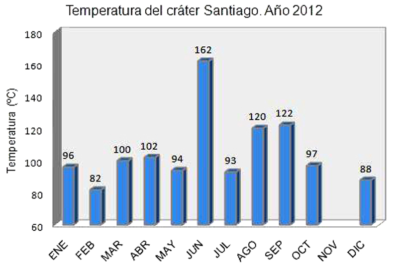 |
Figure 40. Temperatures (°C) measured at Santiago Crater during 2012. Courtesy of INETER (Monthly Report, December 2012). |
On 11 April 2013 thermal anomalies were shown in MODVOLC data (figure 41), but no reports from INETER staff were made at the time. Park rangers did report visible night-time incandescence from the crater in April; INETER staff also noted night-time incandescence on 26 April. This was the only anomalous activity reported in 2013.
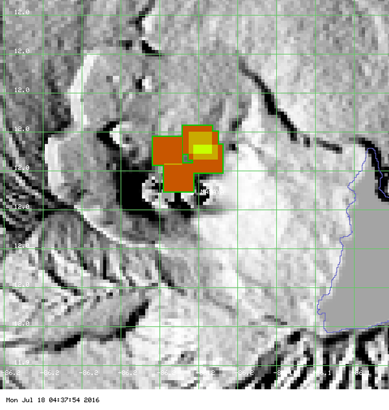 |
Figure 41. Five-pixel thermal anomaly at Masaya on 11 April 2013. Courtesy of MODVOLC. |
Regular measurements of CO2 flux from El Comalito cone, fumarole temperatures from Santiago crater and El Comalito, and SO2 flow across the region were made by INETER staff during 2013, 2014, and 2015. An example of imaging of CO2 flux from April 2013 shows the highest values in the NE section of the Comalito cone (figure 42). Multiyear CO2 data from 2008-2015 for Comalito show a range of values from 66.4 tons per day (t/d) to 15.1 t/d. No specific trend is observed (figure 43).
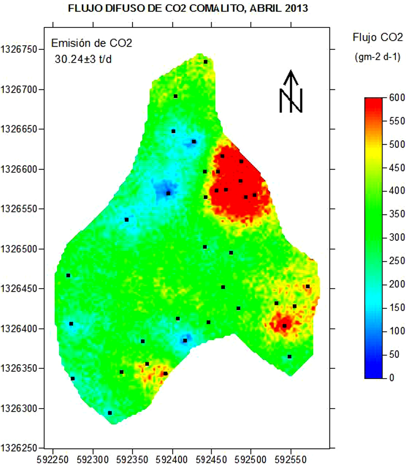 |
Figure 42. CO2 flux measured on 4 April 2013 at Masaya's Comalito Cone. Note the highest flux values are in the NE section of the cone. Courtesy of INETER (Monthly Bulletin, April 2013). |
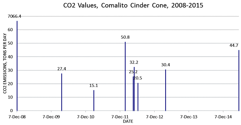 |
Figure 43. Multi-year CO2 measurements for Comalito Cone. The area measured is .09 km2. Actual measurement dates are: 7-Dec-2008, 26-Mar-2010, 2-Mar-2011, 30-Jan-2012, 25-Apr-2012, 4-May-2012, 12-Jun-2012, 4-Apr-2013, and 22-May-2015. Data courtesy of INETER. |
During 24-26 June 2013, INETER volcanology staff performed SO2 measurements in the vicinity of the volcano. Significant variations of flux were observed ranging from 640 to 1721 t/d (figure 44).
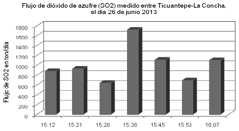 |
Figure 44. SO2 flow at Masaya measured between Ticuantepe (6 km NW) and La Concha (35 km NW), 26 June 2013. Courtesy of INETER (Monthly Bulletin, June 2013). |
During the week of 16-22 September 2013, an increase in seismic tremor signals were measured at the Masaya station. The longest event lasted for 4 hours and 20 minutes on 22 September. SO2 measurements taken during this time showed no specific correlation with the increase in tremor activity.
Seismicity during 2014 was very low with fewer than 10 earthquakes recorded in monthly seismic reports, and RSAM (real-time seismic amplitude) values consistently in the background range averaging 30 units per day. Park staff reported white gas plumes rising 100-250 m above the summit, and landslides within the crater were frequently observed.
A marked increase in seismicity was reported by INETER in April 2015. The total number of events for the month rose to 3,293, with an increase in the daily number of events from a few tens to several hundred per day starting on 15 April 2015, but the RSAM values did not increase. The total number of seismic events during May decreased back to 238. In August 2015, thermal imaging at Santiago crater showed temperatures in the normal range (not higher than 120° C), and a statistically significant correlation between SO2 and RSAM values (figure 45) was observed.
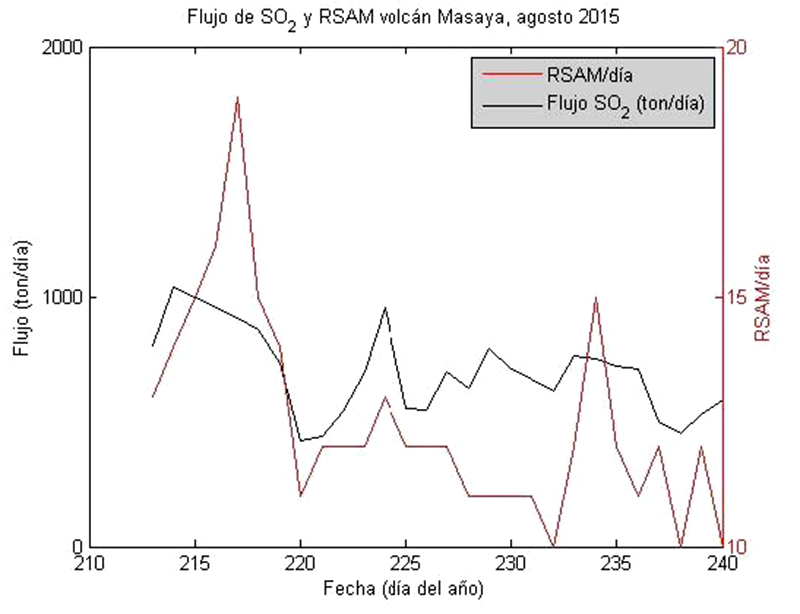 |
Figure 45. Time-series of average daily flows of sulfur dioxide (SO2) (in black) and real-time seismic amplitude (RSAM) (in red) at Masaya's Santiago crater. X-axis values are shown as the day of the year in August 2015. Courtesy of INETER (Monthly Report, August 2015). |
Geological Summary. Masaya volcano in Nicaragua has erupted frequently since the time of the Spanish Conquistadors, when an active lava lake prompted attempts to extract the volcano's molten "gold" until it was found to be basalt rock upon cooling. It lies within the massive Pleistocene Las Sierras caldera and is itself a broad, 6 x 11 km basaltic caldera with steep-sided walls up to 300 m high. The caldera is filled on its NW end by more than a dozen vents that erupted along a circular, 4-km-diameter fracture system. The Nindirí and Masaya cones, the source of observed eruptions, were constructed at the southern end of the fracture system and contain multiple summit craters, including the currently active Santiago crater. A major basaltic Plinian tephra erupted from Masaya about 6,500 years ago. Recent lava flows cover much of the caldera floor and there is a lake at the far eastern end. A lava flow from the 1670 eruption overtopped the north caldera rim. Periods of long-term vigorous gas emission at roughly quarter-century intervals have caused health hazards and crop damage.
Information Contacts: Instituto Nicaragüense de Estudios Territoriales (INETER), Apartado Postal 2110, Managua, Nicaragua (URL: http://webserver2.ineter.gob.ni/vol/dep-vol.html); Hawai'i Institute of Geophysics and Planetology (HIGP), MODVOLC Thermal Alerts System, School of Ocean and Earth Science and Technology (SOEST), Univ. of Hawai'i, 2525 Correa Road, Honolulu, HI 96822, USA (URL: http://modis.higp.hawaii.edu/); Washington Volcanic Ash Advisory Center (VAAC), Satellite Analysis Branch (SAB), NOAA/NESDIS E/SP23, NOAA Science Center Room 401, 5200 Auth Rd, Camp Springs, MD 20746, USA (URL: http://www.ospo.noaa.gov/Products/atmosphere/vaac/)