Report on Ubinas (Peru) — December 2015

Bulletin of the Global Volcanism Network, vol. 40, no. 12 (December 2015)
Managing Editor: Edward Venzke.
Edited by A. Elizabeth Crafford.
Ubinas (Peru) Intermittent explosions through November 2014; ashfall causes evacuations April-June 2014
Please cite this report as:
Global Volcanism Program, 2015. Report on Ubinas (Peru) (Crafford, A.E., and Venzke, E., eds.). Bulletin of the Global Volcanism Network, 40:12. Smithsonian Institution. https://doi.org/10.5479/si.GVP.BGVN201512-354020
Ubinas
Peru
16.345°S, 70.8972°W; summit elev. 5608 m
All times are local (unless otherwise noted)
Ubinas is an active stratovolcano in southern Peru about 70 km E of the city of Arequipa. Although Holocene lava flows cover its flanks, the historical record, which extends back to the mid-1500's, contains evidence of about 20 minor explosive eruptions. In March 2006 ash eruptions began that continued through August 2009. Numerous explosions produced ash plumes rising to 6-9 km in altitude, along with volcanic bombs ejected up to 200 m from the crater (BGVN 31:10). Around 2,000 residents were evacuated from nearby communities in the valley SE of the volcano where most of the ash and debris was directed (figure 21).
Phreatic explosions were again reported by Instituto Geofísico del Perú, Observatoria Vulcanologico del Sur (IGP-OVS) and the Observatorio Volcanológico del INGEMMET (Instituto Geológical Minero y Metalúrgico) (OVI-INGEMMET) beginning 1 September 2013. A series of nine explosions between 1 and 7 September 2013 sent ash plumes to 2 km above the crater and ejected volcanic bombs up to 2 m in diameter. This report details activity at Ubinas from October 2013 through the end of 2014 with information provided by IGP-OVS, OVI-INGEMMET and the Buenos Aires VAAC (Volcanic Ash Advisory Center).
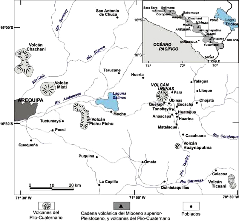 |
Figure 21. Location of Volcan Ubinas and communities around the volcano. The communities SE of the volcano in the Ubinas Valley are the ones most often affected by ashfall from the ash explosions. Courtesy of OVI-INGEMMET and IGP-OVS (2013 Ubinas Report 16). |
Elevated seismic signals continued in October 2013 and January 2014. Explosion and ashfall frequency began to increase in February and March; explosions in April and May sent ash plumes as high as 5,000 m above the crater (altitudes up to 10.6 km). Extrusion of lava was witnessed by geologists in March, and thermal anomalies and seismic evidence in April suggested hot material still at the surface. Ashfall, up to several millimeters thick, was deposited across the region numerous times between April and September 2014, generally S and E of the volcano in villages up to 15 km away, and as far as 40 km on one occasion. Volcanic bombs were ejected as far as 2.5 km from the crater on a few occasions, but did not cause damage in neighboring communities. Activity noticeably declined in October 2014 and the final explosion on 23 November 2014 sent ash plumes to 2,500 m above the crater.
Activity during October 2013-March 2014. After the explosive events of early September 2013, Ubinas was relatively quiet except for a minor 2-minute-long non-explosive seismic signal that likely produced gas-and-ash emissions on 21 October 2013. Activity decreased noticeably through December 2013 but then picked up again in January 2014 with an abrupt increase in the number of LP (long-period) seismic events to 44 in the first days of January and an increase in "tornillo"-type seismic events with an emission on 23 January. Swarms of several tens of earthquakes were recorded on 8, 9, 17 and 25 January leading up to three ash-emission events on 1 and 2 February. IGP-OVS reported that the ash plumes on 1 and 2 February rose to 2 km above the crater (7.6 km altitude) and drifted E and SE. The towns of Querapi and Ubinas (4-6 km SE) received very light ashfall from these events. The number of LP earthquakes increased dramatically to more than 1,200 events in the first seven days of February. IGP reported that exhalation was nearly continuous until 8 February, after which seismic activity decreased significantly. Bluish gas emissions were sporadic during 8-11 February, and a phreatic explosion on 14 February generated a water vapor, gas, and ash plume that rose 1 km above the crater.
Volcanologists visited the crater during 1-2 March and observed a new 30-40 m elongated body of incandescent lava emitting bluish gas. On another visit on 19 March 2014, the lava was photographed covering the 120 m wide crater floor (figure 22).
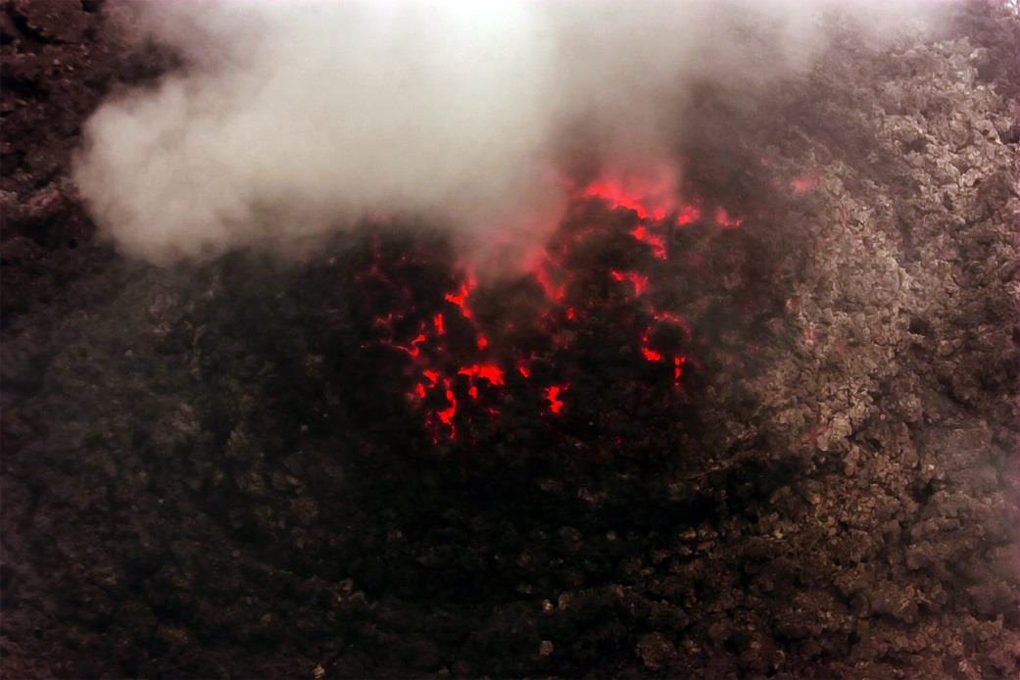 |
Figure 22. Newly erupting lava covering the 120-m-wide floor of the inner crater atop Ubinas on 19 March 2014. Courtesy of IGP-OVS (2014 Ubinas Annual Report). |
Buenos Aires VAAC reports of ash emissions increased significantly in March 2014, with reports of emissions on 13 different days. Diffuse plumes were repeatedly observed drifting in many directions up to 1.7 km above the crater. Ashfall was reported on 25, 27, and 31 March in nearby villages including Ubinas, Querapi, and Tonohaya (7 km SSE), and noises from the volcano were audible around the community of Ubinas. Seismic signals of "hybrid" type, associated with the flow of magma inside the volcano, increased in late March. IGP-OVS also reported MIROVA thermal anomalies that indicated the presence of lava at the surface continuing into early April 2014.
Activity during April 2014-September 2014. Nearly continuous explosive activity characterized events during April 2014, with tens of explosions reported daily and increasing amounts of energy released from seismic events. Early in the month ash plumes were rising almost daily 2-3 km above the volcano, but the height increased to 4.5 km by 15 April and then 5 km above the crater (10.6 km altitude) in the largest explosion on 19 April. Variations in different kinds of seismic activity throughout the month reflected the large amount of energy released during both explosive activity and the eruption of lava (figure 23). Thermal anomalies were captured from MODIS satellite data and reported by the MODVOLC thermal alert system seven times during the first two weeks of April.
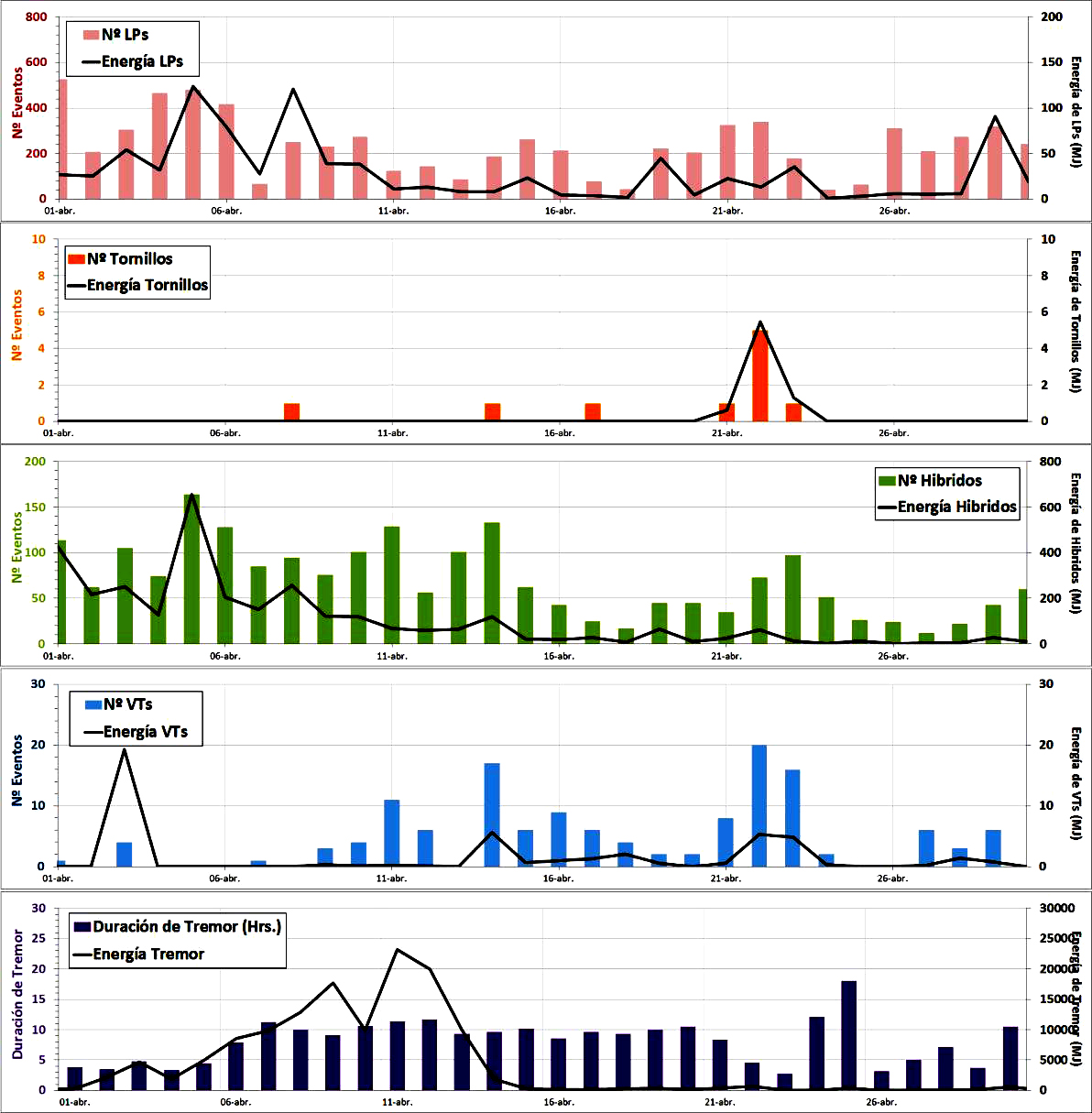 |
Figure 23. Increases in different types of seismicity were observed at different times throughout April 2014 at Ubinas, when vigorous explosive activity occurred. LP events (top graph) are generally interpreted as associated with increased ash emissions. "Tornillo" events (second graph) are associated with a buildup of pressure, and can correlate with subsequent high explosive activity. Hybrid events (third graph) are interpreted as related to the rise of magma inside the volcano, and thus often reflect subsequent extrusive lava flow activity. VT events (fourth graph) are associated with subsurface rock fracturing. Long stretches of time with lengthy durations of tremors (fifth graph) tend to release much of the internal energy built up inside the volcano. Courtesy of IGP-OVS (2014 Ubinas Annual Report). |
Ashfall occurred in local communities many times in April. The towns of Ubinas and Querapi (4-6 km SE) reported ash every week. During the largest explosions from 15-22 April, ash in Querapi was reported up to 1 mm thick, and a trace was recorded in Ubinas. Ash also fell in multiple areas in almost all directions, but was most concentrated to the SE, S, and SW; additional towns affected included Escacha (7 km SE), Tonohaya (8 km SE), San Miguel (10 km SE), Huatagua (14 km SE), Matalaque (17 km SE), Chojata (19 km ESE), Omate, (37 km SSW) and even Quinistaquillas (44 km S).
On 18 April a significant gas-and-ash emission was accompanied by the ejection of incandescent bombs that landed up to 2 km from the crater. Explosions on 19 and 22 April also ejected incandescent tephra, 20-30 cm in diameter, up to 2.5 km away from the crater. Residents and livestock in Tonohaya and Querapi were evacuated during the month. After 21 April, the size of the explosions began to decrease, although significant explosions still deposited ash in villages within about 8 km of the volcano during the rest of the month.
Sulfur dioxide emissions were notable in Aura/OMI satellite data between 15 and 18 April 2014 (figure 24). A maximum value of 4.3 kT was captured on 17 April. They continued at levels approaching 1,000 tons per day intermittently through September; villages downwind reported strong sulfur odors. On 26 April a team of IGP-OVS scientists mapped the sites of the volcanic bombs from the eruptions on 19 April and observed craters 2-4 m in diameter.
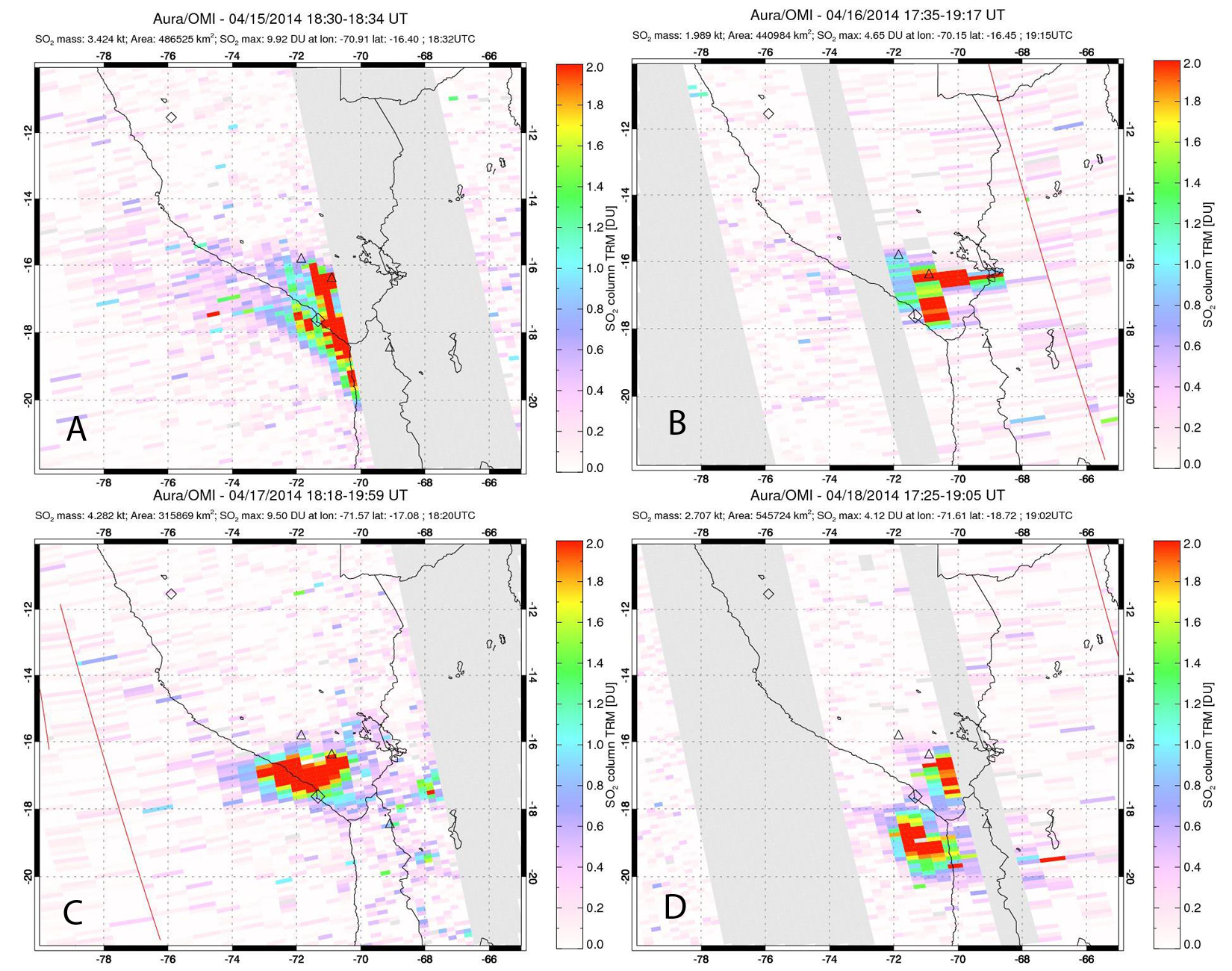 |
Figure 24. Images of SO2 emissions at Ubinas from the OMI instrument on the NASA Aura satellite between 15 and 18 April 2014. Ubinas is the triangle closest to Lake Titicaca. Emission dates and masses shown are as follows: A) 15 April, 3.42 kT; B) 16 April, 1.99 kT; C) 17 April, 4.28 kT; D) 18 April, 2.71 kT. Courtesy of NASA GSFC. |
Early May explosions had ash plumes rising to 3 km or less above the volcano and drifting S and E to Querapi (4 km S), Ubinas (6.5 km SSE), Escacha (7 km SE), Anascapa (10 km SE), San Miguel (10 km SE), and Lloque (17 km E). Explosions with ashfall continued throughout May. Plumes generally rose to 3 km or less above the crater (up to 8.5 km altitude). The ashfall was generally reported within 10 km of the volcano. The wind scattered the ash in almost all directions; however, the largest deposits were located in the E and SSW, which measured up to 3-4 mm of ash in some areas, up to 6 km from the crater.
While the energy released was lower overall in June, frequent explosive events continued, with numerous ash emissions lasting from tens of minutes to hours. During 2-3 June large plume heights up to 5 km above the summit were again reported based on webcam images and pilot reports. Ashfall continued to affect areas around the volcano several days per week, especially within 6 km E and SSW. On 30 June an explosive event sent incandescent lava fragments 1,500 m NW from the crater. This was preceded by an increase in intensity of 'hybrid' earthquakes.
The most significant event in July was an explosion on 17 July that sent an ash column 5,000 m above the crater to 10.7 km altitude (figure 25), drifting SE and scattering fine ash in the villages of Ubinas and Escacha (6-8 km SE). Incandescent blocks were also ejected onto the flanks. Numerous other smaller explosions regularly sent ash plumes to 2-3 km above the summit, with ashfall in the Ubinas valley to the SE.
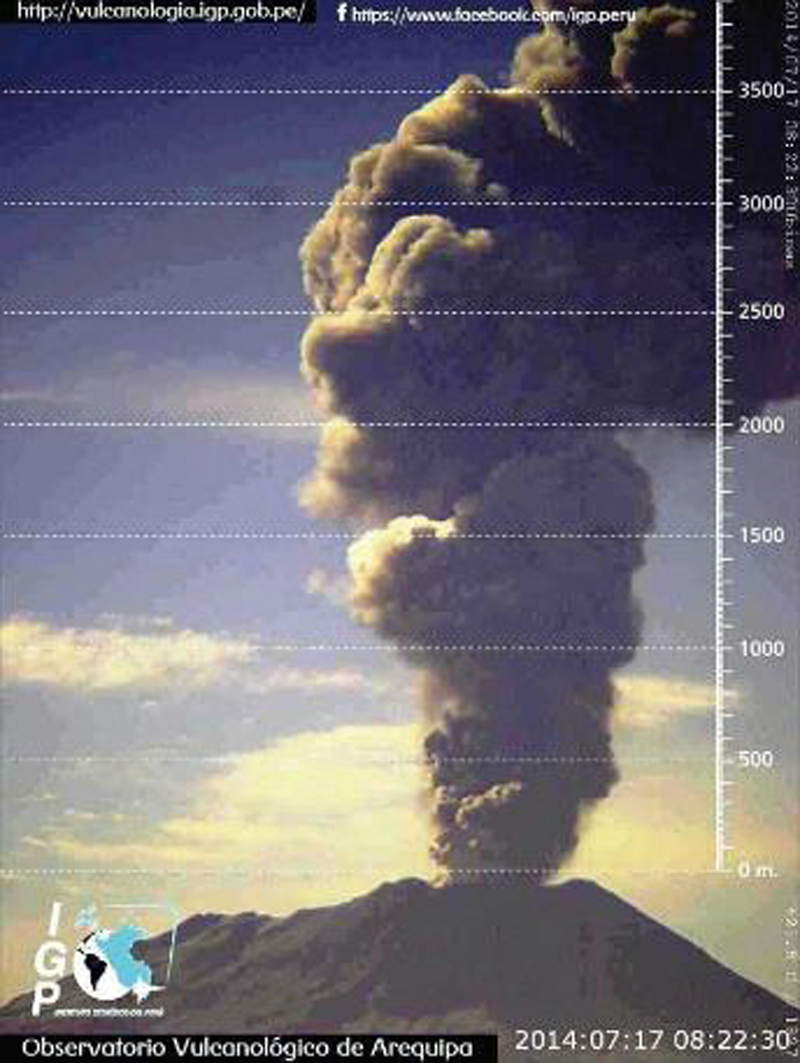 |
Figure 25. An explosion at Ubinas on 17 July 2014 at 0814 local time sent an ash plume 5,000 m above the summit, releasing an energy of 55.3 Megajoules. Courtesy of IGP-OVS (2014 Ubinas Annual Report). |
Sharp declines in seismic tremors were observed in early August 2014; fewer explosions were recorded than in previous months. The largest explosion sent a plume to 4,200 m above the crater, drifting S and SE on 21 August, and sent bombs 2 km onto the S flank. It was heard 10 km from the volcano and caused minor ashfall up to 10 km S and E. Other ash emissions during the month rarely exceed 1,200 m above the crater. Tremor activity increased between 22 and 29 August, associated with persistent ash emissions. Explosions of lesser energy were typical in early September with the highest plume reported on 11 September at 3,000 m above the crater. As ash emissions decreased in late September, steam plumes rising 300 m above the crater were regularly observed. Explosions on 21 and 22 September sent ash columns to 1,300 m above the crater. In the last week of September, small intermittent ash-and-gas emissions rose less than 400 m above the crater.
Activity during October 2014-December 2014. With the exception of an event on 23 October 2014 where a small amount of ash was observed rising to 800 m, emissions were primarily steam rising 300 m or less this month. Between 31 October and 11 November IGP-OVS reported an increase in emissions of steam and ash, some rising to 3,000 m above the crater and drifting S, N, and NE. VT seismic events also increased during this period. The highest steam and ash emissions in mid-November were recorded at 1,600 m above the crater, and drifted both N and S. On 23 November two explosive events released ash plumes that rose 2.5 and 2.2 km above the crater and drifted S and SE. These were the first explosions since 21 September, and were observed by IGP-OVS geophysical staff doing fieldwork. They were also the last explosions of 2014.
An increase in the number of hybrid-type seismic events was noted in December 2014, and also a brief spike in "tornillo" events, but no explosive ash-bearing emissions were reported; however, hybrid seismic event counts were lower compared to earlier in the year (figure 26). When the crater was inspected by IGP-OVS scientists on 15 December, there was no visible magma on the surface. A large increase in LP seismic events was recorded on 26 December.
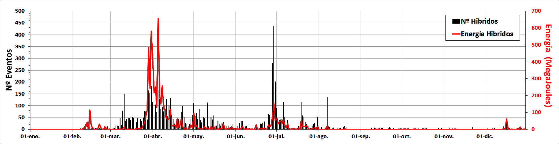 |
Figure 26. Evolution of hybrid-type seismic events in 2014 at Ubinas. The graph clearly shows that the largest episode of activity in the current eruptive cycle occurred during April 2014. Several thermal anomalies were also recorded during early April suggesting the rise of magma to the surface. Courtesy of IGP-OVS (2014 Ubinas Annual Report). |
Geological Summary. The truncated appearance of Ubinas, Perú's most active volcano, is a result of a 1.4-km-wide crater at the summit. It is the northernmost of three young volcanoes located along a regional structural lineament about 50 km behind the main volcanic front. The growth and destruction of Ubinas I was followed by construction of Ubinas II beginning in the mid-Pleistocene. The upper slopes of the andesitic-to-rhyolitic Ubinas II stratovolcano are composed primarily of andesitic and trachyandesitic lava flows and steepen to nearly 45°. The steep-walled, 150-m-deep summit crater contains an ash cone with a 500-m-wide funnel-shaped vent that is 200 m deep. Debris-avalanche deposits from the collapse of the SE flank about 3,700 years ago extend 10 km from the volcano. Widespread Plinian pumice-fall deposits include one from about 1,000 years ago. Holocene lava flows are visible on the flanks, but activity documented since the 16th century has consisted of intermittent minor-to-moderate explosive eruptions.
Information Contacts: Instituto Geofisico del Peru, Observatoria Vulcanologico del Sur (IGP-OVS), Arequipa Regional Office, Urb La Marina B-19, Cayma, Arequipa, Peru (URL: http://ovs.igp.gob.pe/); Observatorio Volcanologico, Instituto Geológical Minero y Metalúrgico (OVI-INGEMMET), Barrio Magisterial Nro. 2 B-16 Umacollo - Yanahuara Arequipa (URL: http://ovi.ingemmet.gob.pe); Buenos Aires Volcanic Ash Advisory Center (VAAC), Servicio Meteorológico Nacional-Fuerza Aérea Argentina, 25 de mayo 658, Buenos Aires, Argentina (URL: http://www.smn.gov.ar/vaac/buenosaires/productos.php); MIROVA, a collaborative project between the Universities of Turin and Florence (Italy) supported by the Centre for Volcanic Risk of the Italian Civil Protection Department (URL: http://www.mirovaweb.it/); Hawai'i Institute of Geophysics and Planetology (HIGP), MODVOLC Thermal Alerts System, School of Ocean and Earth Science and Technology (SOEST), Univ. of Hawai'i, 2525 Correa Road, Honolulu, HI 96822, USA (URL: http://modis.higp.hawaii.edu/); NASA Goddard Space Flight Center, Global Sulfur Dioxide Monitoring Page, Atmospheric Chemistry and Dynamics Laboratory, Goddard, Maryland, USA (URL: https://so2.gsfc.nasa.gov/).