Report on Mayon (Philippines) — March 2016

Bulletin of the Global Volcanism Network, vol. 41, no. 3 (March 2016)
Managing Editor: Edward Venzke.
Research and preparation by Robert Andrews.
Mayon (Philippines) New lava dome appears in summit crater, August 2014; evacuations due to rockfall hazard
Please cite this report as:
Global Volcanism Program, 2016. Report on Mayon (Philippines) (Venzke, E., ed.). Bulletin of the Global Volcanism Network, 41:3. Smithsonian Institution. https://doi.org/10.5479/si.GVP.BGVN201603-273030
Mayon
Philippines
13.257°N, 123.685°E; summit elev. 2462 m
All times are local (unless otherwise noted)
The Philippine Institute of Volcanology and Seismology (PHIVOLCS) reported that visual observations of Mayon volcano's summit crater on 12 August 2014 revealed the growth of a new lava dome approximately 30-50 m high. This event was preceded by inferred low-volume intrusions that cause inflation and increased sulfur dioxide (SO2) emissions (beyond the baseline level of 500 tonnes/day) over the previous two months. The sulfur dioxide flux was 850 t/d on 11 August (table 13). Volcanic earthquakes and rockfalls, however, remained at baseline levels, and almost no crater glow had been observed since May 2014.
Table 13. Measured sulfur dioxide flux (metric tons/day) at Mayon, 11 August-29 September 2014. Baseline level for SO2 is 500 t/d (during quiescence) based on continuous gas measurements since June 2014. Courtesy of PHIVOLCS.
| Date | SO2 flux, t/d |
| 11 Aug 2014 | 850 |
| 19 Aug 2014 | 309 |
| 22 Aug 2014 | 1,266 |
| 29 Aug 2014 | 1,170 |
| 02 Sep 2014 | 611 |
| 06 Sep 2014 | 2,360 |
| 12 Sep 2014 | 457 |
| 14 Sep 2014 | 6,253 |
| 17 Sep 2014 | 757 |
| 22 Sep 2014 | 1,046 |
| 23 Sep 2014 | 569 |
| 24 Sep 2014 | 606 |
| 26 Sep 2014 | 680 |
| 27 Sep 2014 | 1,265 |
| 29 Sep 2014 | 1,421 |
The emergence of the new dome prompted PHIVOLCS to raise the Alert Level on 15 August from 1 to 2 (on a scale of 0-5) (see table 14). Sulfur dioxide flux remained high over the next month, suddenly rising to over 6,000 t/d on 14 September. On 15 September PHIVOLCS raised the Alert Level to 3 and reported that activity had escalated, including 39 rockfalls during 0500-0800 and 32 low-frequency volcanic earthquakes. Crater glow became visible around 2000, and thermal anomalies were detected in MODIS data by MODVOLC (2 pixels). According to a news article some residents in Guinobatan (11.8 km SW) had already evacuated.
White plumes rose from the crater on 16 September (figure 24), with incandescence seen later and incandescent material descending the upper reaches of Bonga Gully on the SE flank. During the previous 24 hours, there were 32 volcanic earthquakes and 72 rockfall events. Incandescent material moving down the cone was obvious at night on 17 September (figure 25), and a news article indicated that almost 24,000 people from villages within an 8-km radius from the crater had been evacuated.
Seismicity and rockfalls increased over the next few days, though clouds prevented visual observations. During 17-18 September the network recorded 142 volcanic earthquakes and 251 rockfall events. White steam plumes drifting SSW were noted. The network recorded 38 volcanic earthquakes and 277 rockfall events during 18-19 September. During 19-21 September four volcanic earthquakes along with 8-22 rockfall events per day were recorded. White steam plumes drifted ENE and NNE during 20-21 September. During 21-23 September three volcanic earthquakes per day and 13-18 rockfalls per day were recorded; white steam plumes drifted NNE, NE, ENE, and SW.
 |
Figure 24. Mayon volcano emits white plumes as seen from Legazpi, Albay province, SE of Manila on 16 September 2014. Courtesy of Charism SAYAT/AFP/Getty Images via The Weather Channel. |
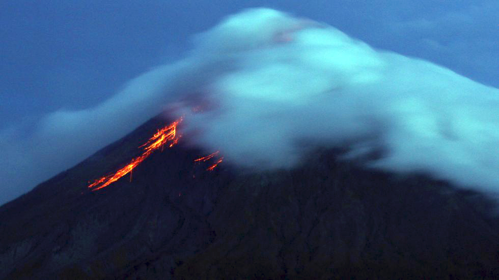 |
Figure 25. Lava flows from the crater of Mayon volcano seen from Legazpi City, Albay province, southeast of Manila on 17 September 2014. Courtesy of Charism SAYAT/AFP/Getty Images via The Weather Channel. |
According to a news article, the Albay Province Public Safety and Emergency Management Office stated that more than 54,000 people were in evacuation shelters as of 30 September. On 12 October the Office of the Governor of Albay issued a statement noting that 12,602 families (about 56,000 people) had been relocated to 46 evacuation centers.
Volcanic earthquakes (up to nine per day) and rockfalls (as many as six per day) continued to be detected at least through 12 October. During an overflight on 12 October 2014, volcanologists from PHIVOLCS observed a 350-m-long lava flow traveling down the SE flank, on the E side of Bonga Gully. The report noted that the small number of volcanic earthquakes and rockfall signals during the previous few days indicated slow lava extrusion from the crater and a slow-moving lava flow downslope. On 14 October a seismic signal indicating a rockfall was recorded and a brief period of incandescence from the crater was observed. During 14-21 October white plumes rose from the crater and drifted NW, W, WSW, SW, and SE, and a few volcanic earthquakes were recorded during 18-21 October. On 19 October weak incandescence from the crater was noted. A new lava flow first observed later that same day was 300-400 m long by 20 October, based on an aerial survey. Weak crater incandescence from the lava dome was again seen on 21 October.
During 22 October-4 November 2014, white plumes rose from the crater and drifted SW, WSW, WNW, and NW. Weak incandescence from the crater was noted at night on 22, 25, 27, and 28 October, and a few volcanic earthquakes and rockfall signals were periodically recorded.
A PHIVOLCS report on 4 November 2014 noted that ground deformation continued to be detected (since the beginning of 2014). Tilt data from the network on the NW flank indicated continuing inflation since August, subsequent to a period of inflation in June and July. Precise leveling measurements also indicated sustained inflation.
White plumes continued to rise from the crater in November and early December 2014, and weak incandescence was noted some nights. As many as five volcanic earthquakes were recorded per day. Data from a deformation study conducted during 9-13 November 2014 indicated deflation relative to 21-28 October, although the volcano remained inflated relative to the baseline.
On 19 December 2014, PHIVOLCS reported a general decline in the overall activity since a seismic swarm last detected on 29 November. Specifically, for the previous three weeks, seismic activity had declined to an average 2-3 mostly volcano-tectonic earthquakes daily, a few low-frequency earthquakes, and a few minor rockfall events. In addition, deformation data did not indicate magma intrusion; sulfur dioxide emissions had declined on 2 October 2014 to below the baseline value; no lava flows had been observed since 19 October.
The Alert Level was lowered to 2 (on a 0-5 scale) on 19 December 2014. Activity continued to decrease; the Alert Level was reduced to 1 (abnormal) on 3 September 2015 and to 0 (no alert) on 12 February 2016.
Table 14. Mayon volcano Alert Levels as revised on 15 August 2014. Courtesy of PHIVOLCS.
| Alert Level | Main Criteria | Interpretation/Recommendations |
| 0. No Alert | Quiet. All monitored parameters within background levels. | No eruption in foreseeable future. Entry in the 6-km radius Permanent Danger Zone (PDZ) is not advised because phreatic explosions and ash puffs may occur without precursors. |
| 1. Abnormal | Low level unrest. Slight increase in seismicity. Slight increase in SO2 gas output above the background level. Very faint glow of the crater may occur but no conclusive evidence of magma ascent. Phreatic explosion or ash puffs may occur. | No eruption imminent. Activity may be hydrothermal, magmatic or tectonic in origin. No entry in the 6-km radius PDZ. |
| 2. Increasing unrest | Moderate unrest. Low to moderate level of seismic activity. Increasing SO2 flux Faint/intermittent crater glow. Swelling of edifice may be detected. Confirmed reports of decrease in flow of wells and springs during rainy season. | Unrest probably of magmatic origin; could eventually lead to eruption. 6-km radius Danger Zone may be extended to 7 km in the sector where the crater rim is low. |
| 3. Increased tendency towards eruption | Relatively high unrest. Volcanic quakes and tremor may become more frequent. Further increase in SO2 flux. Occurrence of rockfalls in summit area. Vigorous steaming / sustained crater glow. Persistent swelling of edifice. | Magma is close to the crater. If trend is one of increasing unrest, eruption is possible within weeks. Extension of Danger Zone in the sector where the crater rim is low will be considered. |
| 4. Hazardous eruption imminent | Intense unrest. Persistent tremor, many "low frequency"-type earthquakes. SO2 emission level may show sustained increase or abrupt decrease. Intense crater glow. Incandescent lava dome, lava fountain, lava flow in the summit area. | Hazardous eruption is possible within days. Extension of Danger zone to 8 km or more in the sector where the crater rim is low will be recommended. |
| 5. Hazardous eruption | Hazardous eruption ongoing. Occurrence of pyroclastic flows, tall eruption columns and extensive ashfall. | Pyroclastic flows may sweep down along gullies and channels, especially along those fronting the low part(s) of the crater rim. Additional danger areas may be identified as eruption progresses. Danger to aircraft, by way of ash cloud encounter, depending on height of eruption column and/or wind drift. |
Geological Summary. Symmetrical Mayon, which rises above the Albay Gulf NW of Legazpi City, is the most active volcano of the Philippines. The steep upper slopes are capped by a small summit crater. Recorded eruptions since 1616 CE range from Strombolian to basaltic Plinian, with cyclical activity beginning with basaltic eruptions, followed by longer term andesitic lava flows. Eruptions occur predominately from the central conduit and have also produced lava flows that travel far down the flanks. Pyroclastic flows and mudflows have commonly swept down many of the approximately 40 ravines that radiate from the summit and have often damaged populated lowland areas. A violent eruption in 1814 killed more than 1,200 people and devastated several towns.
Information Contacts: Philippine Institute of Volcanology and Seismology (PHIVOLCS), Department of Science and Technology, University of the Philippines Campus, Diliman, Quezon City, Philippines (URL: http://www.phivolcs.dost.gov.ph/); Office of the Governor of Albay, Philippines (URL: http://albay.gov.ph/); Philippine Daily Inquirer (URL: http://www.inquirer.net/); Associated Press (URL: http://www.ap.org/); The Weather Channel, 17 Sept. 2014 (URL: https://weather.com/); Inquirer.net (URL: http://newsinfo.inquirer.net/641491/phivolcs-volume-of-magma-moving-up-mayon-similar-to-2009-eruption); BBC News (URL: http://www.bbc.com/news/world-asia-29217253); Daily Mail (URL: http://www.dailymail.co.uk/).