Report on Nishinoshima (Japan) — September 2016

Bulletin of the Global Volcanism Network, vol. 41, no. 9 (September 2016)
Managing Editor: Edward Venzke.
Edited by A. Elizabeth Crafford.
Nishinoshima (Japan) Continued ash plumes and lava flows from vent on E side of cone through mid-November 2015
Please cite this report as:
Global Volcanism Program, 2016. Report on Nishinoshima (Japan) (Crafford, A.E., and Venzke, E., eds.). Bulletin of the Global Volcanism Network, 41:9. Smithsonian Institution. https://doi.org/10.5479/si.GVP.BGVN201609-284096
Nishinoshima
Japan
27.247°N, 140.874°E; summit elev. 100 m
All times are local (unless otherwise noted)
Japan's Nishinoshima volcano erupted above sea level in November 2013 for the first time in 40 years, and grew dramatically outward from a central pyroclastic cone and other vents with extensive lava flows, Strombolian eruptions, and ash plumes that rose as high as 1.2 km in 2014. The area of the island grew from approximately 0.29 to 2.29 km2 during 2014, reaching an elevation of around 100 m according to the Japan Coast Guard (JCG). Information about Nishinoshima comes primarily from monthly reports provided by the Japan Meteorological Agency (JMA) and photographs taken by the Japan Coast Guard (JCG), which monitors the volcano due to its remote location in the Pacific Ocean, approximately 940 km S of Tokyo along the Izu-Bonin arc.
Active growth due to lava flows erupting from vents around the central pyroclastic cone continued through mid-November 2015 when the eruption ended. Observations by the JCG showed that lava flows stopped sometime between visits on 12 and 17 November; the last MODVOLC thermal alert was on 14 November, and MIROVA data showed a drop in energy output a few days later. Ash plumes from explosions were still occurring on 17 November, but no eruptive activity was seen during a 22 December visit. Monthly overflights by the JCG documented the growth of the island, which ended the year with an area of approximately 2.63 km2.
The first 2015 aerial observation conducted by the JCG on 21 January revealed that eruptions at Crater 7 (atop the central pyroclastic cone) continued with a gray ash plume rising to 500 m and drifting W. Lava was flowing to the E side of the island and spreading outward like a fan flowing into the sea over a large area (figure 30). Lava was also observed flowing from a vent at the base of the eastern side of the pyroclastic cone, which was emitting blueish-white gas (figure 31). Discolored water along the coastline of the island drifted from E to N and from the W coast near the original island to the S.
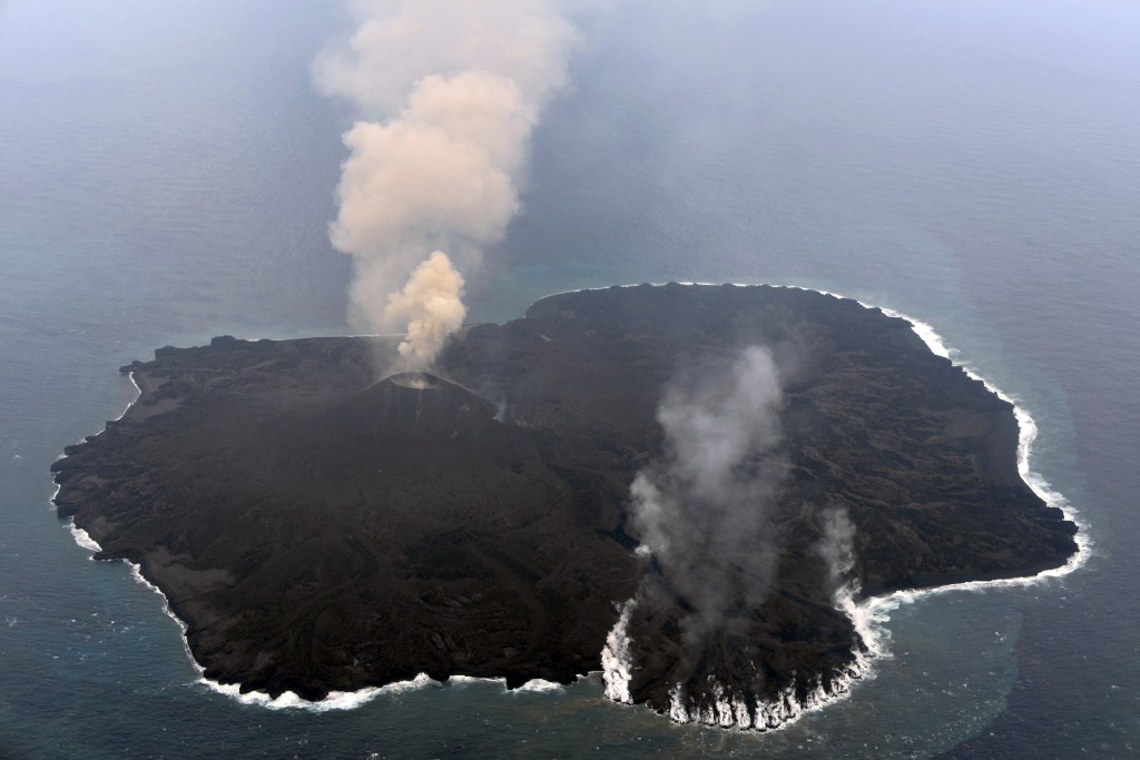 |
Figure 30. Lava spread east like a fan from the central cone on Nishinoshima on 21 January 2015, flowing into the sea and generating steam plumes across a broad area. Brown ash plumes from the cone rose 500 m and drifted W. Courtesy of Japan Coast Guard. |
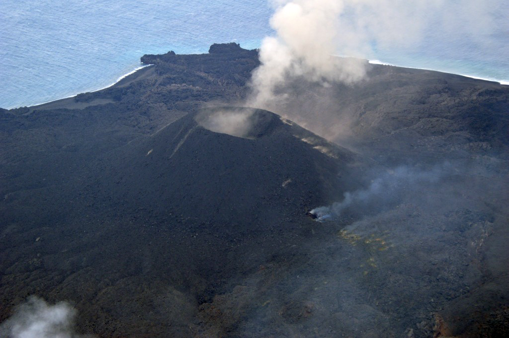 |
Figure 31. Bluish-white gas emitting from a vent at the base of the pyroclastic cone on Nishinoshima on 21 January 2015. Much of the lava that erupted in 2015 came from this vent. Courtesy of Japan Coast Guard. |
The area of newly formed land continued to expand in February 2015. Aerial observation on 23 February revealed ongoing Strombolian eruptions at Crater 7 that produced brown plumes and emitted lava. White to gray plumes rose as high as 1,200 m. Lava was flowing to the E side of the island and yellowish-green and brown discolored water was observed around the whole coastline except for the southern part (figure 32). The discolored area extended around 1,000 m to the NE with a width of 700 m, and around 1,500 m to the SE with a width of 1,000 m.
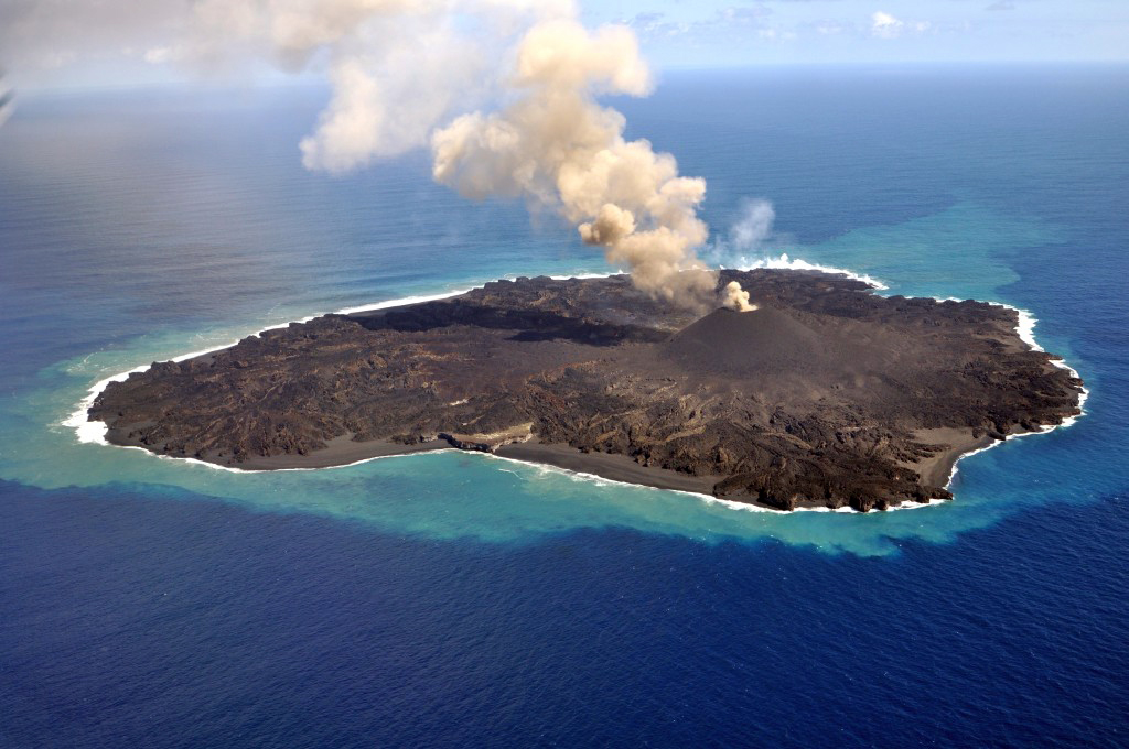 |
Figure 32. View of Nishinoshima volcano on 23 February 2015. Brownish-gray ash plumes rose to 1,200 m from the central crater. Note yellow-green discolored water surrounding the island. Courtesy of Japan Coast Guard. |
In March, the lava flowed to the N and W from the pyroclastic cone, and ash plumes rose to 1,300 m and drifted generally S. Observations in late April revealed lava flowing from the vent on the NE side of the cone, forming a new lava field to the north of the cone (figure 33). The lava stream then flowed NE through a lava tube to the coast. By May the lava from the vent was flowing SE to the ocean and forming vapor spouts at the entry point. On 20 May the yellowish-green plume in the water was observed 10 km to the SW of the island (figure 34). Bluish-white emissions continued from the vent on the eastern side of the cone in June (figure 35) as lava from the vent flowed SE to the ocean.
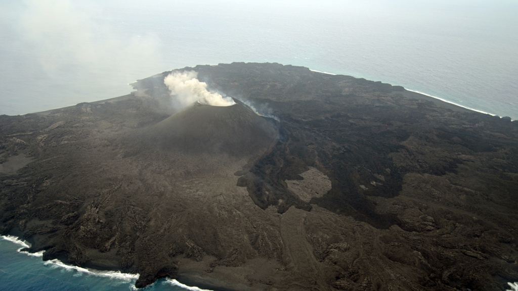 |
Figure 33. New lava field flowing N and E from the side vent on the cone of Nishinoshima on 27 April 2015. Courtesy of Japan Coast Guard. |
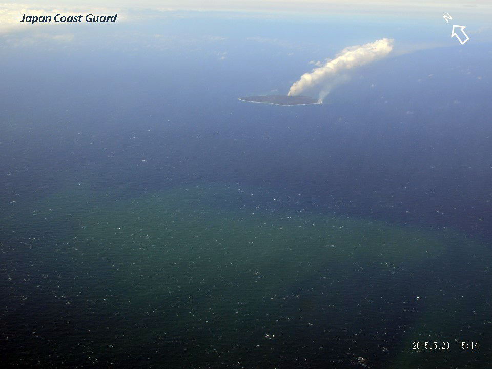 |
Figure 34. The yellowish-green plume from Nishinoshima is visible 10 km SW of the island. Both the ash-and-steam plume from the pyroclastic cone and the vapor spouts from the lava flows entering the sea are also visible in this image from 20 May 2015. The dimensions of the discolored water are 4,000 m from east to west and around 2,000 m from north to south. Courtesy of Japan Coast Guard. |
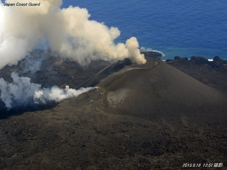 |
Figure 35. Blue-white gas and steam emissions from the vent on the eastern side of Nishinoshima's Crater 7 cone on 18 June 2015 are distinct from the brownish ash plume coming from the crater at the top of the cone. Courtesy of Japan Coast Guard. |
Fewer explosive eruptions were observed in July 2015. Areal observation on 31 July revealed a new crater in the vent on the north side of Crater 7. Lava flowed N and ENE from the NE slope of the pyroclastic cone in August as well as E and S through a lava tube. Some of the lava continued to reach the coast. The land expanded to the ESE due to lava flows, but coastline recession was observed in several places, especially on the southern side as a result of wave erosion. Aerial observation conducted on 23 August revealed the continued emission of blueish-white to white volcanic gas at the rim of the crater and fumaroles on the W, SE, and NE slope of the pyroclastic cone where white-to-yellow volcanic sublimate was widely distributed (figure 36).
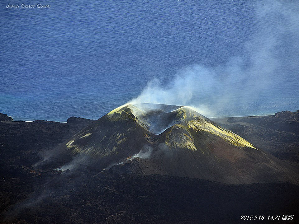 |
Figure 36. White and yellow sublimate from outgassing at Nishinoshima was first observed in August, but continued to expand in this image from 16 September 2015. Lava flows continued to emerge from vents on the NE side of the cone. Courtesy of Japan Coast Guard. |
Aerial observation on 16 September revealed lava from the NE side of the pyroclastic cone flowing W, NW, and SE. On 13 October the JCG observed small eruptions at Crater 7 occurring every three to five minutes. The lava field on the lower side of the NE slope of the cone had thickened, and lava flowed to the N and W. No lava flow was observed reaching the sea, and no significant changes were observed along the coast of the island. No eruptions at the crater were seen during a brief aerial observation conducted on 29 October, but weak fumes were observed rising around the crater. Yellowish-green discolored water was seen along the coast of the island with a width of around 50 to 200 m.
On 12 November JCG observed intermittent emissions of gray plumes from Crater 7. Lava flowed around 200 m SW from a newly formed outlet on the SW side of the cone. Aerial observation conducted on 17 November by JCG and the Earthquake Research Institute of the University of Tokyo revealed that the lava flow from the SW side of the pyroclastic cone had become slightly thicker and larger. It was also observed that a lava flow from the N side of the cone, which had been active since 17 September 2014, had stopped flowing. Eruptions occurred once or twice an hour from Crater 7 during the 17 November visit, and grayish-brown plumes rose to heights of 300 to 500 m. The eruptions sent volcanic projectiles with diameters of several meters to distances of 500 to 1,000 m from the crater and as far as the ocean on the SW side of the island (figure 37).
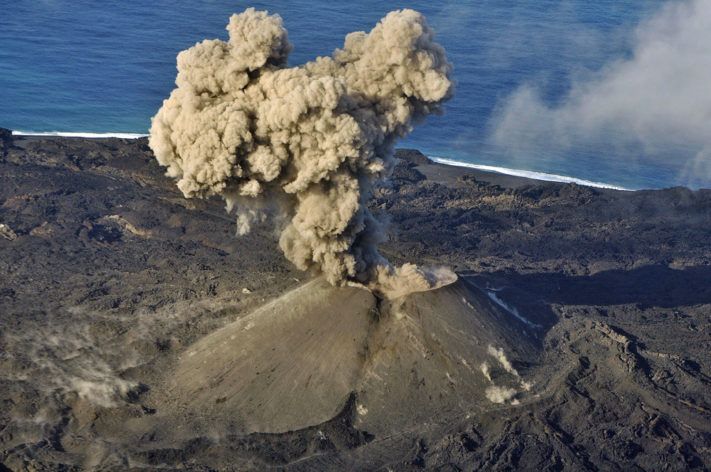 |
Figure 37. Eruption plumes observed at Nishinoshima on 17 November 2015. Projectiles were observed to distances of 1,000 m from the crater. Note the dark, fresh lava from the vent in the lower foreground, and wisps of steam rising from many small projectiles around the cone. Courtesy of Japan Coast Guard. |
No indication of eruptive activity was observed at Crater 7 or other parts of the island during aerial observation on 22 December by the JCG. Very weak white plumes were seen coming from the inner wall of the crater and the southern foot of the pyroclastic cone. No new lava flows were observed. Thermal measurements revealed no high-temperature areas on the island (including the crater or around new lava flows), and showed a remarkable decline in temperature compared with that observed on 17 November. The newly formed land covered around 1,900 m east-west and 1,920 m north-south. Its total area was around 2.62 km2, very similar to the previous measurement in November.
Moderate Resolution Imaging Spectroradiometer (MODIS) infrared satellite data revealed the impressive extent of thermal anomalies produced through mid-November 2015. Over 1,000 pixels of thermal anomalies were mapped by the MODVOLC system during 2015. Most days had 3-5-pixel anomalies; some days had as many as ten or more, indicating extensive output of lava. The MIROVA (Middle InfraRed Observation of Volcanic Activity) system's analysis of the 'Log Radiative Power' from MODIS data (figure 38) confirms the high amount of heat energy coming from the volcano during this time, and also corroborates a mid-November cessation of activity. The last MODVOLC thermal anomaly pixel is from 14 November, and the MIROVA data shows an abrupt decline of heat flow a few days later.
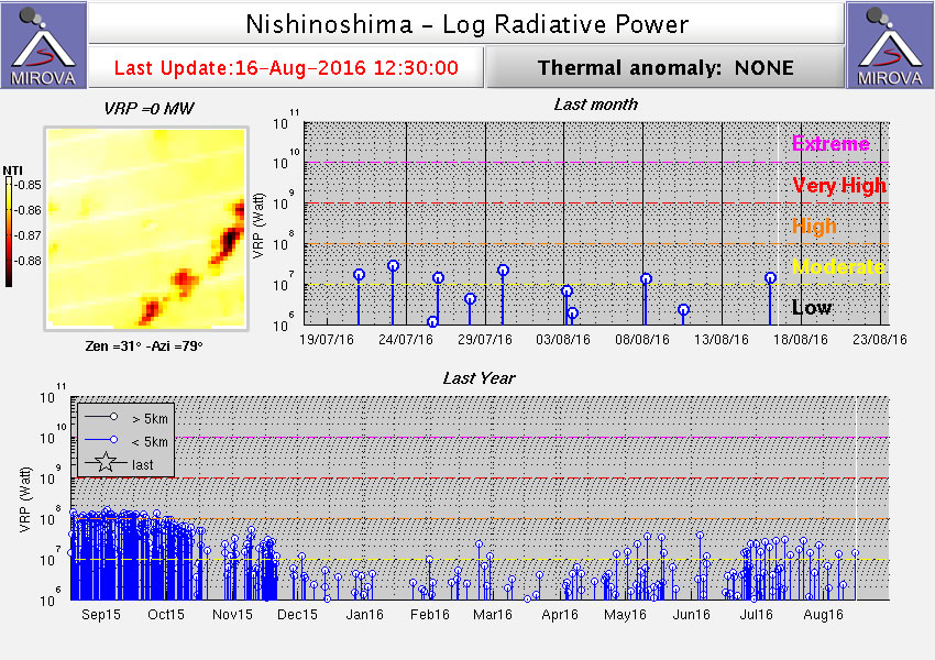 |
Figure 38. Log Radiative Power of MIROVA system analysis of MODIS data for Nishinoshima from the year ending 15 August 2016. Note the abrupt decline of energy after 15 November 2015, agreeing with the observations of JCG in December that there was little evidence of active eruption or heat flow at that time. Image courtesy MIROVA. |
Geological Summary. The small island of Nishinoshima was enlarged when several new islands coalesced during an eruption in 1973-74. Multiple eruptions that began in 2013 completely covered the previous exposed surface and continued to enlarge the island. The island is the summit of a massive submarine volcano that has prominent peaks to the S, W, and NE. The summit of the southern cone rises to within 214 m of the ocean surface 9 km SSE.
Information Contacts: Japan Meteorological Agency (JMA), Otemachi, 1-3-4, Chiyoda-ku Tokyo 100-8122, Japan (URL: http://www.jma.go.jp/); Japan Coast Guard (JCG), Policy Evaluation and Public Relations Office, 100-8918, 2-1-3 Kasumigaseki, Chiyoda-ku, Tokyo (URL: http://www.kaiho.mlit.go.jp/e/index_e.htm, JCG Nishinoshima Data Site: http://www1.kaiho.mlit.go.jp/GIJUTSUKOKUSAI/kaiikiDB/kaiyo18-e1.htm); Hawai'i Institute of Geophysics and Planetology (HIGP), MODVOLC Thermal Alerts System, School of Ocean and Earth Science and Technology (SOEST), Univ. of Hawai'i, 2525 Correa Road, Honolulu, HI 96822, USA (URL: http://modis.higp.hawaii.edu/); MIROVA, a collaborative project between the Universities of Turin and Florence (Italy) supported by the Centre for Volcanic Risk of the Italian Civil Protection Department (URL: http://www.mirovaweb.it/).