Report on Karangetang (Indonesia) — February 2017

Bulletin of the Global Volcanism Network, vol. 42, no. 2 (February 2017)
Managing Editor: Edward Venzke.
Edited by A. Elizabeth Crafford.
Karangetang (Indonesia) Intermittent ash plumes, lava flows, pyroclastic flows, and lahars; persistent thermal anomalies, June 2014-December 2016
Please cite this report as:
Global Volcanism Program, 2017. Report on Karangetang (Indonesia) (Crafford, A.E., and Venzke, E., eds.). Bulletin of the Global Volcanism Network, 42:2. Smithsonian Institution. https://doi.org/10.5479/si.GVP.BGVN201702-267020
Karangetang
Indonesia
2.781°N, 125.407°E; summit elev. 1797 m
All times are local (unless otherwise noted)
The Karangetang andesitic-basaltic stratovolcano (also referred to as Api Siau) at the northern end of the island of Siau, north of Sulawesi, Indonesia has had more than 50 historically-observed eruptions since 1675. Frequent explosive activity is accompanied by pyroclastic flows and lahars, and lava-dome growth has created multiple summit craters. Rock avalanches, observed incandescence, and satellite thermal anomalies at the summit confirmed continuing volcanic activity through 5 September 2013 (BGVN 39:01). Activity is monitored by Indonesia's Pusat Vulkanologi dan Mitigasi Bencana Geologi (PVMBG, also known as CVGHM, or the Center of Volcanology and Geological Hazard Mitigation), and ash plumes are monitored by the Darwin VAAC (Volcanic Ash Advisory Center). Information is also available from MODIS thermal anomaly satellite data through both the University of Hawaii's MODVOLC system and the Italian MIROVA project.
An ash plume reported by the Darwin VAAC on 9 February 2014 that rose to an altitude of 4.3 km (2.5 km above the summit) and drifted over 80 km W was the only recorded activity at Karangetang between MODVOLC thermal anomalies on 5 September 2013 and on 8 June 2014. Additional thermal anomalies identified between June and September 2014, and increased seismicity reported by PVMBG in September, indicated ongoing activity. An ash plume was reported by the Darwin VAAC in October 2014. A spike in thermal activity was recognized during 12 January-1 February 2015. Another strong thermal signal began on 13 May that continued through 9 December 2015, when visual reports of lava flows and ash plumes were all recorded. Ash plumes were last reported by the Darwin VAAC in January 2016; night incandescence at the summit was reported by PVMBG until 15 March 2016. The Alert Level remained at 3 from September 2013 through 16 March 2016, when it was lowered to 2. Persistent low-energy thermal anomalies were captured by MIROVA throughout 2016, but there were no PVMBG observations indicating ongoing dome growth or other eruptive activity.
Activity during 2014. On 9 February 2014, the Darwin VAAC reported an ash plume rising to 4.3 km and extending over 80 km to the W based on satellite images. The next observation of activity was a single MODVOLC thermal alert pixel on 8 June 2014 located precisely over the summit. More substantial thermal anomalies appeared between 19 and 24 July, followed by two more on 2 August, after which there is a break of more than five months with no MODVOLC thermal anomalies. The MIROVA system, however, does record intermittent, low-level anomalies through early December 2014 (figure 11).
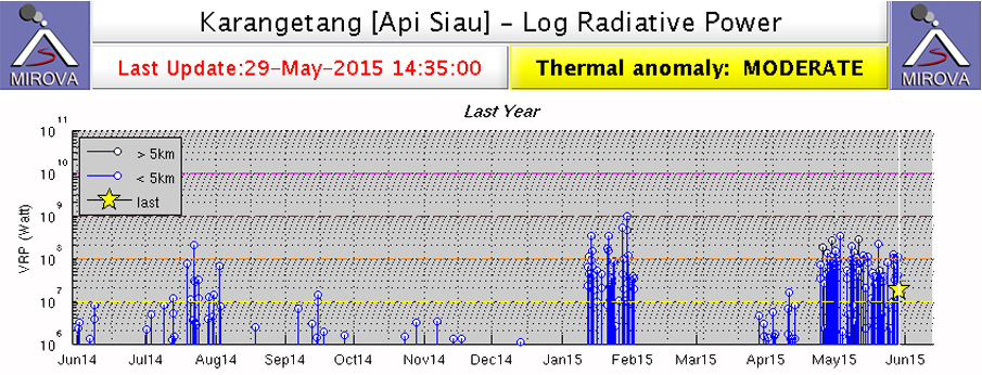 |
Figure 11. MIROVA Log Radiative Power Thermal Anomaly data for 29 May 2014 through 29 May 2015 at Karangetang. Activity increases during July 2014 and slowly tapers off into December before the sudden appearance of a moderate to high thermal anomaly was recorded between 12 January and 1 February 2015. Activity increases again in early April 2015. Image courtesy of MIROVA. |
On 15 September 2014, PVMBG issued a report noting that seismic amplitudes were relatively high at the volcano, increasing from much lower levels on 12 September. Seismic data also indicated an increase in earthquakes indicating avalanches in late July which corresponded in time with the thermal anomalies recorded by MODVOLC and MIROVA. PVMBG observed steam plumes rising to between 100 and 150 m above the main summit crater, and to around 25 m above the second crater during the second week of September 2014, along with incandescence at the summit. The last 2014 report of activity came from the Darwin VAAC; they reported an ash plume on 20 October rising to 3 km and drifting 75 km NW.
Activity during 2015. Both the MODVOLC and MIROVA systems report the abrupt appearance of strong thermal anomalies on 12 January 2015, continuing until 1 February when they stopped just as suddenly (figure 11). A news article by a local newspaper (Jaringan Berita Terluas di Indonesia) reported that a lahar on 22 January 2015, triggered by heavy rains, descended the volcano's flanks, overflowed the banks of the Batu River, and damaged a number of public and private buildings in the village of Bahu about 7.5 km S of the volcano, and in Bebali, 4.5 km S. It also damaged the main road between the communities of Ulu and Ondong but the debris was quickly cleared by authorities.
The MIROVA system recorded thermal anomalies beginning again at the very end of March 2015 (figure 11); MODVOLC noted a single thermal alert on 13 April, and then strong, multi-pixel anomalies nearly continuously from 24 April through 11 June 2015. During the second half of April, PVMBG staff at the Volcano Observation Post in the village of Salili, 4 km SW, noted white steam plumes ranging from 50 to 350 m above the main crater and 25 m above the second crater, and incandescence from the summit. Additionally, they observed bluish-white plumes on 16 and 17 April rising to 50-150 m. They also concluded that the amplitude of seismic activity had decreased since the end of February.
Lava flows were first observed on 22 April; incandescent avalanches from the fronts of 150-m-long lava flows traveled up to 2 km down Batuawang and Kahetang drainages (E) during 22-29 April. On 26 April pyroclastic flows traveled 2.2 km along the Kahetang drainage. On 28 April explosions produced plumes and ejected incandescent material 50 m high (figure 12). Seismicity also increased from the previous week. The MIROVA data indicated a sudden spike of high thermal activity beginning around 22 April and continuing past the end of May (figure 11).
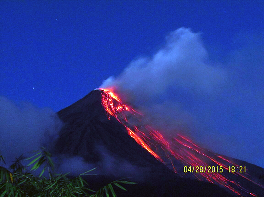 |
Figure 12. Incandescent lava flowing down Karangetang's flanks on 28 April 2015. Courtesy of PVMBG (G. Karangetang Activity Report, 29 April 2015). |
Activity at the volcano increased significantly at the beginning of May 2015. BNPB (Badan Nasional Penanggulangan Bencana) reported that on 7 May at 1400 an eruption that ejected incandescent material and produced a dense ash plume also generated a pyroclastic flow that traveled 4 km E, leveling four houses in Kora-Kora. The next day pyroclastic flows descended the S flank 2.5 km into the Kahetang (E) and Batuawang drainages. There were no reported fatalities; 465 people were evacuated from the village of Bebali, 4.5 km S. Also on 8 May, the Darwin VAAC reported an ash plume that rose to an altitude of 3 km drifted almost 85 km E, and dissipated two days later. On 12 May another ash plume rose to an altitude of 3.7 km and drifted 55 km SW, and there were reports by the Darwin VAAC via social media of continued pyroclastic flow activity. Steam plumes rising to 400 m continued into the last week of May, along with incandescence from the summit at night. The lava flows that first appeared on 22 April were 300 m long by the end of May and continued to send block avalanches from the fronts up to 2 km down the Batuawang, Kahetang, and Keting drainages to the SW, S and SE. Seismic amplitudes continued at a high level; seismicity was dominated by signals characteristic of avalanches, with harmonic tremor frequently detected.
On 5 June 2015 BNPB reported that activity remained high; a total of 339 people (106 families) from the villages of Ulu, Salili, Belali, and Tarorane, all a few kilometers S of the summit, remained displaced since early May. PVMBG reported that on 18 June a lahar descending Batuawang drainage (E) covered a 100-m section of roadway with 25 cm of mud containing 1-m-diameter boulders. The lahar also damaged or destroyed four homes. White plumes rising 150 m above the main crater and 25 m above crater II were observed from the Volcano Observation Post in Salili during late June. Incandescence from the lava dome was also observed at night. Lava flowed from the S part of the dome; incandescent avalanches from the front of the lava flow again traveled up to 2.3 km down the Batuawang and Kahetang drainages. Seismic activity continued to be high, although the number of daily earthquake indicating avalanches had dropped below 100 per day at the end of June. MODVOLC thermal anomaly pixels were recorded on 2-4, 9, and 11 June, far fewer than in May.
PVMBG reported that during the last two weeks of July 2015, white plumes rose 250 m above the main crater and 25 m above the second crater (crater II). Incandescence from the lava dome was observed at night when skies were clear, and incandescent avalanches from the fronts of new 150-m-long lava flows traveled up to 2.3 km E down the Batuawang, Kahetang and Keting drainages. Seismicity was dominated by signals characteristic of avalanches, with rare volcanic earthquakes. The Alert Level remained at 3. During the month, fewer MODVOLC thermal alerts were recorded than during May and June, only on 4, 6, 11, and 25 July.
Seismicity related to avalanche activity increased significantly on 14 August 2015 and the number of daily events spiked on 20 August to 599, marking a period of increased activity that continued into November (figure 13). Strong MODVOLC thermal alert signals reappeared on 10 August 2015 and continued with multiple-pixel signals almost daily until 1 October when they became more intermittent. The MIROVA thermal anomaly data also corroborated increased thermal activity during this period (figure 14).
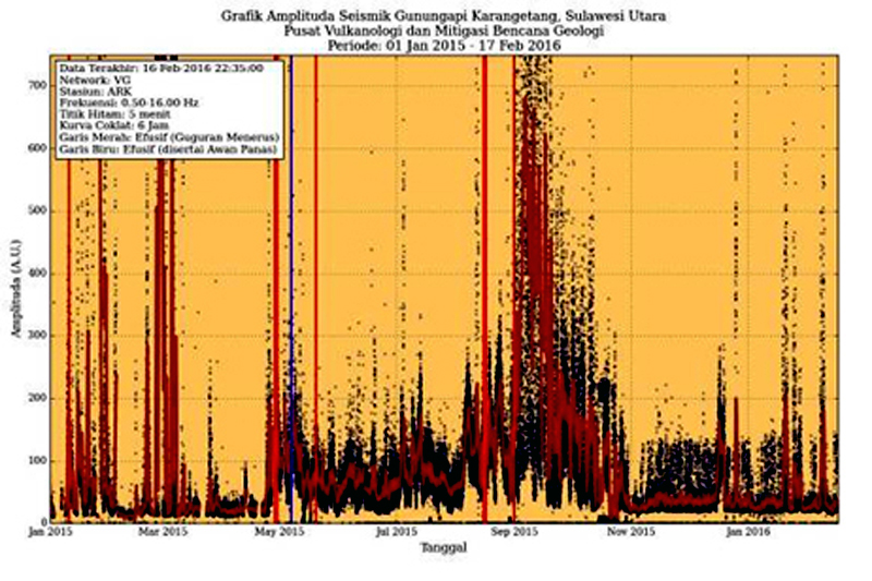 |
Figure 13. Seismic amplitude data (RSAM) from Karangetang, 1 January 2015 through 17 February 2016. Activity increased notably in the third week of August 2015 and remained elevated through the end of October, followed by intermittent pulses of activity through February 2016. Courtesy of PVMBG, (G. Karangetang Activity Report, 17 February 2015). |
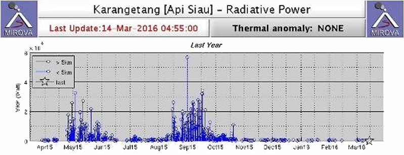 |
Figure 14. MIROVA thermal anomaly data for Karangetang from 14 March 2015 through 14 March 2016. The tapering of activity between May and July 2015 corresponds well with MODVOLC, seismic, and observational data for that period. Heightened activity between August and October 2015 also corresponds with increased seismic activity, abundant MODVOLC thermal anomaly pixels, visual observations of lava flows and ash plumes, and numerous VAAC reports during this time. Courtesy of MIROVA (published originally by PVMBG in G. Karangetang Activity Report, 16 March 2016). |
The Darwin VAAC reported that on 28 August 2015 a pyroclastic cloud was observed on satellite. The ash plume rose to an altitude of 2.4 km and drifted 55 km ENE. They also observed a number of ash plumes between 10 and 17 September that rose as high as 3 km and drifted up to 130 km generally E. Lava fountains as high as 300 m were observed from the Volcano Observation Post in Salili during 9-16 September. Debris fell as far as 300 m from the summit crater into the Kinali River. Incandescent avalanches from the fronts of 200-m-long lava flows traveled up to 2.5 km down the Batuawang, Kahetang, Keting, and Batang drainages; brownish smoke was observed at the end of the Batuawang flows. The Alert Level remained at 3.
During October 2015, MODVOLC thermal anomaly pixels became more intermittent, appearing on 10 days during the month, far fewer than September. Steam plumes from the main crater were observed from Salili up to 150 m above the crater along with incandescence on clear nights. Lava flows remained active 200 m from the crater still sending pyroclastic avalanches down the Batuawang, Kahetang, Keting, and Batang drainages up to 2 km from the lava fronts. The flows had increased to 600 m long between 19 and 22 October and the avalanches continued. Most seismicity decreased in early October, except harmonic tremor, suggesting that magma movement inside the volcano persisted. The Darwin VAAC reported that on 8 October an ash plume rose to an altitude of 2.7 km and drifted 65 km E and that during 18 October ash plumes rose to an altitude of 2.1 km and drifted 75-95 km NE. Constant harmonic tremors for 6 hours on 20 October indicated magma was still active.
Seismicity continued its steady decline since early September during November (figure 13), although tremor activity continued. Incandescence was still visible from the lava dome at night according to PVMBG, and the incandescent avalanches were still travelling up to 1.5 km down the Batuawang and Kahetang drainages. Steam plumes rose generally 50-200 m, and occasionally 400 m from the main crater. A lahar in Batuawang drainage flowed as far as the village of Bebali and covered about 50 m of the Ondong-Ulu highway on 20 November, similar to the event of 18 June. MODVOLC recorded only two thermal anomaly pixels at the summit, both on 25 November.
By December 2015, incandescence was still observed at the crater from the Volcano Observatory in Salili, but steam plumes rarely exceeded 150 m. A single MODVOLC thermal anomaly pixel, was recorded on 9 December, and spikes in seismic amplitudes were recorded on 21 and 22 December.
Activity during 2016. According to PVMBG, Karangetang was quiet during most of January 2016, although incandescence was reported from the main crater, and plumes of bluish and white smoke rose 50-100 m. There were no reports of active lava flows or incandescent avalanches, but the accumulation of material in the Batuawang drainage made the possibility of damaging lahars during the rainy season very high. The relatively constant number of shallow (VB) earthquakes suggested that the lava dome was growing slowly; there was a two-fold increase in RSAM values during the month (figure 13). Based on analyses of satellite imagery and wind data, the Darwin VAAC reported three ash plumes during the month; on 12 January an ash plume rose to an altitude of 5.2 km and drifted 65 km NW, on 14 January a steam-and-ash plume rose to an altitude of 5.2 km and drifted over 35 km W, and the next day an ash-and-steam plume rose to an altitude of 2.7 km and drifted about 20 km SW.
Incandescence continued at the summit during February and early March 2016 along with bluish-white plumes rising 25-100 m from the summit crater. Seismic energy values (RSAM) remained elevated during February, suggesting continued growth of the lava dome. The last MODIS thermal anomaly observed by PVMBG was on 8 March. Although they continued to observe incandescence 10-25 m above the summit and bluish-white emissions to 150 m through 15 March, they lowered the Alert Level from 3 to 2 on 16 March, noting that even though the RSAM seismic energy values were still above normal, they had been stable for some time. The MIROVA Thermal Anomaly Radiative Power data from March 2016 also showed a significant decline in thermal energy released from the volcano compared with the period from late April through November 2015 (figure 14). Although no further reports were issued by PVMBG or Darwin VAAC, the thermal anomalies detected by MIROVA continued at low to moderate levels during 2016, suggesting a persistent heat source at the volcano (figure 15).
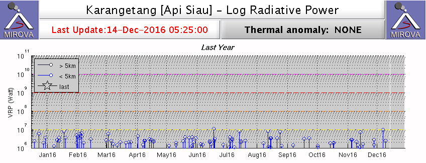 |
Figure 15. MIROVA Log Radiative Power Thermal Anomaly data for Karangetang from 14 Dec 2015 through 14 December 2016 showing continued low-energy thermal anomalies during the period. Courtesy of MIROVA. |
Geological Summary. Karangetang (Api Siau) volcano lies at the northern end of the island of Siau, about 125 km NNE of the NE-most point of Sulawesi. The stratovolcano contains five summit craters along a N-S line. It is one of Indonesia's most active volcanoes, with more than 40 eruptions recorded since 1675 and many additional small eruptions that were not documented (Neumann van Padang, 1951). Twentieth-century eruptions have included frequent explosive activity sometimes accompanied by pyroclastic flows and lahars. Lava dome growth has occurred in the summit craters; collapse of lava flow fronts have produced pyroclastic flows.
Information Contacts: Pusat Vulkanologi dan Mitigasi Bencana Geologi (PVMBG, also known as Indonesian Center for Volcanology and Geological Hazard Mitigation, CVGHM), Jalan Diponegoro 57, Bandung 40122, Indonesia (URL: http://www.vsi.esdm.go.id/); Badan Nasional Penanggulangan Bencana (BNPB), National Disaster Management Agency, Graha BNPB - Jl. Scout Kav.38 East Jakarta 13120 (URL: http://www.bnpb.go.id/); Darwin Volcanic Ash Advisory Centre (VAAC), Bureau of Meteorology, Northern Territory Regional Office, PO Box 40050, Casuarina, NT 0811, Australia (URL: http://www.bom.gov.au/info/vaac/); Hawai'i Institute of Geophysics and Planetology (HIGP), MODVOLC Thermal Alerts System, School of Ocean and Earth Science and Technology (SOEST), Univ. of Hawai'i, 2525 Correa Road, Honolulu, HI 96822, USA (URL: http://modis.higp.hawaii.edu/, http://modis.higp.hawaii.edu/cgi-bin/modisnew.cgi); MIROVA (Middle InfraRed Observation of Volcanic Activity), a collaborative project between the Universities of Turin and Florence (Italy) supported by the Centre for Volcanic Risk of the Italian Civil Protection Department (URL: http://www.mirovaweb.it/); Jaringan Berita Terluas di Indonesia, http://www.jpnn.com/read/2015/01/23/283204/Awas,-Lahar-Dingin-Karangetang-Kembali-Mengancam.