Report on Barren Island (India) — March 2017

Bulletin of the Global Volcanism Network, vol. 42, no. 3 (March 2017)
Managing Editor: Edward Venzke.
Research and preparation by Paul Berger.
Barren Island (India) Intermittent ash plumes and thermal anomalies continue from July 2014 through February 2017
Please cite this report as:
Global Volcanism Program, 2017. Report on Barren Island (India) (Venzke, E., ed.). Bulletin of the Global Volcanism Network, 42:3. Smithsonian Institution. https://doi.org/10.5479/si.GVP.BGVN201703-260010
Barren Island
India
12.278°N, 93.858°E; summit elev. 354 m
All times are local (unless otherwise noted)
The eruptive activity at Barren Island that began in October 2013 continued through at least mid-June 2014 (BGVN 39:07). Another eruptive cycle began in March 2015 and continued through 28 February 2016, based on MODIS/MODVOLC thermal anomalies. However, MIROVA hotspots were regular through mid-May 2016, and then sporadic throughout the rest of 2016. The next clear episode began on 15 January 2017 and continued through at least February 2017. Scientists aboard a research ship observed explosions, fire fountains, and lava flows in January 2017.
Activity during October 2013-June 2014. Evidence of renewed activity in the form of lava flows was seen in MODVOLC thermal anomaly data beginning on 12 October 2013. Thermal alert pixels were frequent through 12 February 2014, followed by single anomalies on 12 March and 20 April 2014. Ash plumes were also observed during January-April 2014. Thermal infrared MODIS data processed by the MIROVA system revealed frequent anomalies in April through early May 2014, and in late May to early June; another anomaly was seen in mid-June 2014.
Activity during July 2014-June 2015. No thermal anomalies were seen in MIROVA data for at least five weeks (figure 24), between early June and late July 2014, and then continuing intermittently through the first half of March 2015. The only reported plumes during this time were in the week of 3-9 September 2014 and 22-28 April 2015, but in each case as could not be identified in satellite imagery.
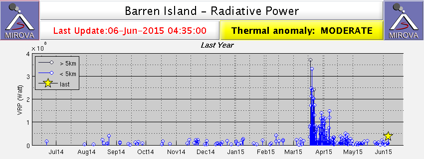 |
Figure 24. Thermal anomaly MIROVA radiative power data from Barren Island during 7 June 2014-6 June 2015. A weak mid-June 2014 anomaly is followed by intermittent weak activity during late July 2014 through mid-March 2015. A strong period of thermal anomalies in March and April 2015 decreased in intensity but continued into early June 2015. Courtesy of MIROVA. |
A strong thermal signature resumed on 17 March 2015 (figure 24) and continued for about three weeks before decreasing in intensity. Lower-level thermal activity continued through the first half of June. Thermal anomalies seen in MODVOLC data also resumed on 17 March, and were frequent through 12 June. Eruptions of ash were observed during 5-7 and 12-13 June 2015, with plumes rising to an altitude of 2-3 km and drifting up to 55 km downwind (table 5).
Table 5. Ash plumes at Barren Island, June 2015-February 2016. Legend: Satellite=analysis of satellite images, wind=wind data. Data provided by the Darwin Volcanic Ash Advisory Centre.
| Date | Max. Altitude (km) | Drift | Basis of report |
| 2015 Jun 5-7 | 2.4-3 | 35-45 km NE, E | Satellite, wind |
| 2015 Jun 12-13 | 2.1 | 25-55 km NE | Pilot, satellite, wind |
| 2015 Aug 19 | 1.5 | 55 km E | Satellite, wind |
| 2015 Sep 22 | 1.8 | 45 km E | Satellite, wind |
| 2015 Oct 8-9 | 1.5-2.1 | 75-100 km NE | Satellite, wind |
| 2016 Jan 3-4 | 1.5 | 85 km SW | Satellite, wind |
| 2016 Jan 31-Feb 2 | 1.5 | 165 km SW | Satellite, wind |
| 2016 Feb 14-15 | 1.5 | Over 45 km W | Satellite, wind |
Activity during July 2015-May 2016. Thermal activity paused again for approximately a month in the second half of June and first half of July 2015. Regular thermal anomalies in MODVOLC data stopped after 12 June and resumed on 16 July. Episodic clusters of anomalies with gaps of 1-3 weeks continued until 28 February 2016. Although MODVOLC data did not show thermal anomalies after February 2016, MIROVA data showed ongoing activity until approximately 17 May (figure 25).
A few ash plumes were seen during this period, on 19 August, 22 September, and 8-9 October 2015 (table 5). There were no reported plumes in November or December 2015, but were seen once again in January and February 2016. Plumes typically rose to an altitude of 1.5-2 km and drifted 45-100 km downwind; the longest plume extended 1665 km SW.
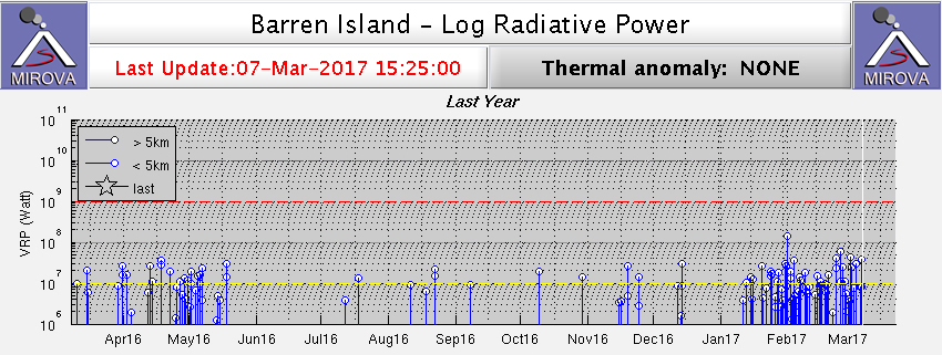 |
Figure 25. Thermal anomaly MIROVA log radiative power data from Barren Island during 21 February 2016-20 February 2017. Regular activity is evident from late February through mid-May 2016. After a gap of about two months, there are only infrequent anomalies through mid-January 2017, after which another episode of frequent anomalies began. Courtesy of MIROVA. |
Activity during June 2016-February 2017. Eruptive activity apparently stopped around 16-17 May 2016 for at least seven weeks. MODIS thermal data captured by MIROVA showed a few anomalies (less than 20) from the second half of July through the first half of December 2016 (figure 25). Considering the remote location and rare direct observations at this island volcano, it is possible that the anomalies represent intermittent lava emissions. Regular thermal anomalies were recorded by both MIROVA and MODVOLC beginning on 15 January that were continuing at the end of February 2017.
The National Institute of Oceanography (NIO), part of the Indian Council of Scientific and Industrial Research (CSIR), reported activity on 23 January 2017. Scientists aboard a research vessel were collecting sea floor samples when they observed a sudden ash emission. The team moved closer, about 1.6 km from the volcano, and noted small eruptive episodes lasting 5-10 minutes. Ash emissions were visible in the daytime, and lava fountains feeding lava flows on the flanks were visible at night. The team revisited the volcano on 26 January and observed similar activity over four hours. They sampled sediments and water in the vicinity of the eruption and recovered volcanic ejecta.
Geological Summary. Barren Island, a possession of India in the Andaman Sea about 135 km NE of Port Blair in the Andaman Islands, is the only historically active volcano along the N-S volcanic arc extending between Sumatra and Burma (Myanmar). It is the emergent summit of a volcano that rises from a depth of about 2250 m. The small, uninhabited 3-km-wide island contains a roughly 2-km-wide caldera with walls 250-350 m high. The caldera, which is open to the sea on the west, was created during a major explosive eruption in the late Pleistocene that produced pyroclastic-flow and -surge deposits. Historical eruptions have changed the morphology of the pyroclastic cone in the center of the caldera, and lava flows that fill much of the caldera floor have reached the sea along the western coast.
Information Contacts: Darwin Volcanic Ash Advisory Centre (VAAC), Bureau of Meteorology, Northern Territory Regional Office, PO Box 40050, Casuarina, NT 0811, Australia (URL: http://www.bom.gov.au/info/vaac/); The National Institute of Oceanography (NIO), Council of Scientific and Industrial Research (CSIR), New Delhi, India (URL: http://www.nio.org/); Hawai'i Institute of Geophysics and Planetology (HIGP), MODVOLC Thermal Alerts System, School of Ocean and Earth Science and Technology (SOEST), Univ. of Hawai'i, 2525 Correa Road, Honolulu, HI 96822, USA (URL: http://modis.higp.hawaii.edu/); MIROVA (Middle InfraRed Observation of Volcanic Activity), a collaborative project between the Universities of Turin and Florence (Italy) supported by the Centre for Volcanic Risk of the Italian Civil Protection Department (URL: http://www.mirovaweb.it/).