Report on Kambalny (Russia) — July 2017
Bulletin of the Global Volcanism Network, vol. 42, no. 7 (July 2017)
Managing Editor: Edward Venzke.
Research and preparation by Robert Andrews.
Kambalny (Russia) First major eruption in over 600 years consists of large ash explosions during March-April 2017
Please cite this report as:
Global Volcanism Program, 2017. Report on Kambalny (Russia) (Venzke, E., ed.). Bulletin of the Global Volcanism Network, 42:7. Smithsonian Institution. https://doi.org/10.5479/si.GVP.BGVN201707-300010
Kambalny
Russia
51.306°N, 156.875°E; summit elev. 2116 m
All times are local (unless otherwise noted)
The last major eruption at Kambalny volcano was around 1350, although younger undated tephra layers have been found; there are also five Holocene cinder cones on the W and SE flanks. According to the Kamchatkan Volcanic Eruption Response Team (KVERT), a new eruption began began at about 2120 UTC on 24 March 2017. Satellite data showed an initial ash plume at about 5-6 km altitude drifting about 35 km SW from the volcano.
Explosive activity was strong during 24-27 March, generating ash plumes up to 7 km high that drifted downwind as far as 2,000 km (table 1). Activity then decreased, with only minor ash emissions through 6 April, followed by ash plumes that drifted 50 and 170 km on 9 and 10 April, respectively. Only gas-and-steam plumes were reported after that time.
Table 1. Chronological details of the March-April 2017 eruption of Kambalny. Data from KVERT reports.
| Date | Time (UTC) | Plume height (km) | Drift (km) | Other observations |
| 24 Mar 2017 | 2250 | 5-6 | 35 SW | Aviation Color Code Orange |
| 25 Mar 2017 | 0053 | 5-6 | 100 SSW | -- |
| 25 Mar 2017 | 0240 | 5-6 | 163 SSW | -- |
| 25 Mar 2017 | 0409 | 5-7 | 255 SW | -- |
| 25 Mar 2017 | 1250 | 5 | 550 SSW | -- |
| 25 Mar 2017 | 1807 | 6 | 870 SSW | -- |
| 25 Mar 2017 | 2250 | 5.5 | 930 S | -- |
| 26 Mar 2017 | 0530 | 5 | 1,350 SSE | -- |
| 26 Mar 2017 | 2131 | 3.5-4 | 670 SE | -- |
| 27 Mar 2017 | 0041 | 5 | 830 SE | -- |
| 27 Mar 2017 | 0347 | 4-4.5 | 425 SE | -- |
| 27 Mar 2017 | 2119 | 4-5 | 51 W | -- |
| 27-31 Mar 2017 | -- | 5-6 | 2,000 W to SE | -- |
| 01 Apr 2017 | -- | -- | 200 E, SE | Quiet. |
| 02-04 Apr 2017 | -- | 7 | -- | Minor ash emissions thru 6 Apr; satellite thermal anomaly 3-4 Apr. |
| 09 Apr 2017 | -- | 7 | 50 NE | -- |
| 10 Apr 2017 | -- | -- | 170 SE | -- |
| 12 Apr 2017 | -- | -- | -- | Gas-and-steam activity. |
| 21-28 Apr 2017 | -- | -- | -- | Moderate activity. |
| 05 May 2017 | -- | -- | -- | Aviation Color Code Yellow. Moderate gas-steam activity. |
| 19 May 2017 | -- | -- | -- | Aviation Color Code Yellow Green. Only gas-steam activity during last month; explosive phase began 24 Mar, ended 10 Apr 2017. |
On 25 March satellite imagery showed an ash plume stretching about 100 km SW of the Kamchatka Peninsula (figure 1). A dark stain is visible to the W of the plume, where ash has covered the snow. By 26 March ashfall had covered the ground on both sides of the volcano. The eruption was also observed on the ground by staff at the South Kamchatka Federal Wildlife Sanctuary (figure 2). The Ozone Monitoring Instrument on the Aura satellite observed an airborne plume of sulfur dioxide (SO2) trailing S of Kamchatka on 26 March 2017 (figure 3).
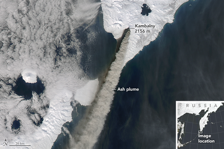 |
Figure 1. The Moderate Resolution Imaging Spectroradiometer (MODIS) on the Terra satellite captured a natural-color image of Kambalny and its plume on 25 March 2017, the day after it began to erupt (N to top of photo.) By 0134 UTC (1334 local time) that day, the plume stretched about 100 km SW. Courtesy of NASA Earth Observatory; image prepared by Jeff Schmatlz and Joshua Stevens using MODIS data from LANCE/EOSDIS Rapid Response, and caption by Pola Lem. |
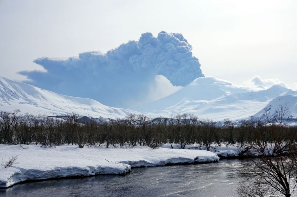 |
Figure 2. Eruption of Kambalny on 25 March 2017. Photo by Liana Varavskaya, South Kamchatka Federal Wildlife Sanctuary (URL: http://www.kronoki.ru/news/1187). |
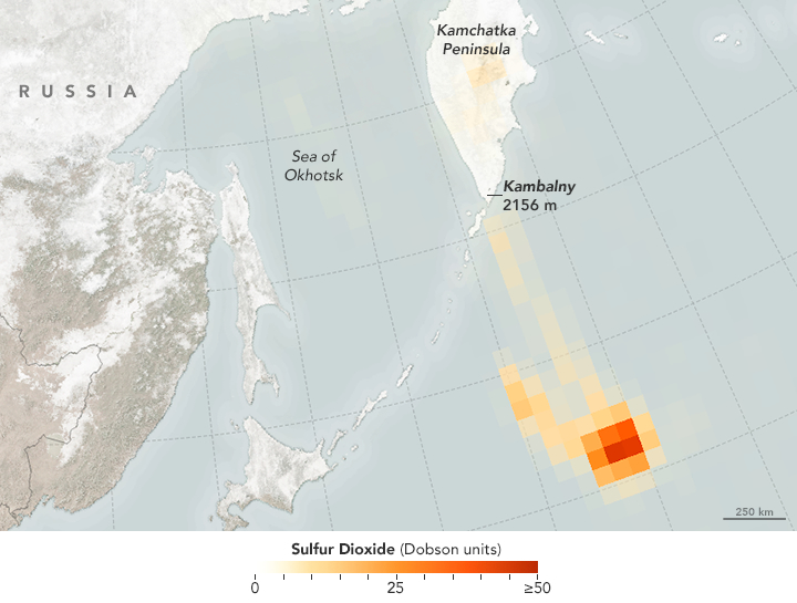 |
Figure 3. Sulfur dioxide in the 26 March 2017 plume from Kambalny eruption. Courtesy of NASA Earth Observatory; map by Joshua Stevens using data from the Aura OMI science team. |
On 28 March 2017, the Operational Land Imager (OLI) on the Landsat 8 satellite acquired a natural-color image of an ash plume from Kambalny (figure 4), including a large area of ash-covered snow. When photographed by scientists on 12 April (figure 5), the entire edifice was covered by ash and there was a gas-and-steam plume rising from a crater fumarole.
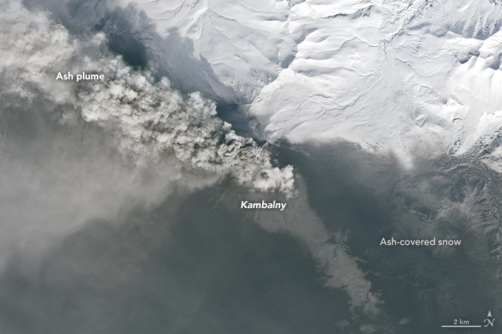 |
Figure 4. Ash plume from Kambalny moving WNW on 28 March 2017. A large area of ash-covered snow is visible across the southern portion of the image. Courtesy of NASA Earth Observatory; image by Joshua Stevens using Landsat 8 OLI data from the U.S. Geological Survey. |
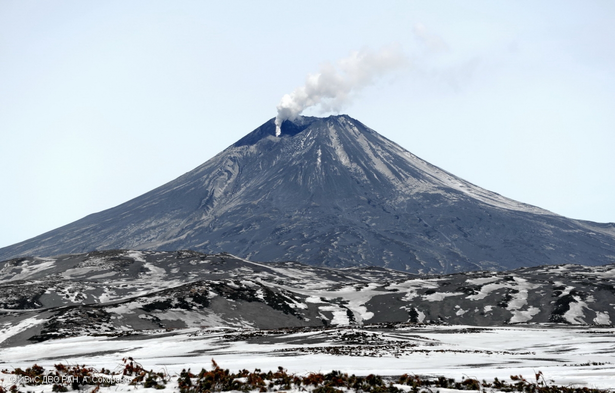 |
Figure 5. A small gas-and-steam plume rises from a fumarole in the Kambalny crater on 12 April 2017. View is from the S. Photo by A. Sokorenko; courtesy of IVS FEB RAS. |
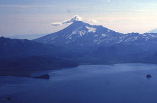
Geological Summary. The southernmost major stratovolcano on the Kamchatka peninsula, Kambalny has a summit crater that is breached to the SE. Five Holocene cinder cones on the W and SE flanks have produced fresh-looking lava flows. Beginning about 6,300 radiocarbon years ago, a series of major collapses of the edifice produced at least three debris-avalanche deposits. The last major eruption took place about 600 years ago, although younger tephra layers have been found, and an eruption was reported in 1767. Active fumarolic areas are found on the flanks of the volcano, which is located south of the massive Pauzhetka volcano-tectonic depression.
Information Contacts: Kamchatka Volcanic Eruptions Response Team (KVERT), Far Eastern Branch, Russian Academy of Sciences, 9 Piip Blvd., Petropavlovsk-Kamchatsky, 683006, Russia (URL: http://www.kscnet.ru/ivs/kvert/); Institute of Volcanology and Seismology, Far Eastern Branch, Russian Academy of Sciences, (IVS FEB RAS), 9 Piip Blvd., Petropavlovsk-Kamchatsky 683006, Russia (URL: http://www.kscnet.ru/ivs/eng/); South Kamchatka Federal Wildlife Sanctuary, Ministry of Natural Resources and Ecology of the Russian Federation, Kamchatka Territory 684000, Russia (URL: http://www.kronoki.ru/); NASA Earth Observatory, EOS Project Science Office, NASA Goddard Space Flight Center, Goddard, Maryland, USA (URL: http://earthobservatory.nasa.gov/); NASA Goddard Space Flight Center (NASA/GSFC), Global Sulfur Dioxide Monitoring Page, Atmospheric Chemistry and Dynamics Laboratory, 8800 Greenbelt Road, Goddard, Maryland, USA (URL: https://so2.gsfc.nasa.gov/).