Report on Heard (Australia) — October 2017
Bulletin of the Global Volcanism Network, vol. 42, no. 10 (October 2017)
Managing Editor: Edward Venzke.
Edited by A. Elizabeth Crafford.
Heard (Australia) Expedition visit in March-April 2016, intermittent eruptive activity through September 2017
Please cite this report as:
Global Volcanism Program, 2017. Report on Heard (Australia) (Crafford, A.E., and Venzke, E., eds.). Bulletin of the Global Volcanism Network, 42:10. Smithsonian Institution. https://doi.org/10.5479/si.GVP.BGVN201710-234010
Heard
Australia
53.106°S, 73.513°E; summit elev. 2745 m
All times are local (unless otherwise noted)
The remote island of Heard in the southern Indian Ocean is home to the Big Ben stratovolcano, which has had confirmed intermittent activity since 1910. The nearest continental landmass, Antarctica, lies over 1,000 km S. Visual confirmation of lava flows on Heard are rare; thermal anomalies detected by satellite-based instruments provide the most reliable information about eruptive activity. Thermal alerts reappeared in September 2012 after a four-year hiatus (BGVN 38:01), and have been intermittent since that time. Information comes primarily from MODVOLC and MIROVA thermal anomaly data, but Australia's Commonwealth Scientific and Industrial Research Organisation (CSIRO) also provides reports from research expeditions. The independent March-April 2016 Cordell Expedition also provided recent ground-based observations mentioned in this report, which covers activity through September 2017.
Expeditions during January-April 2016. Scientists aboard the CSIRO Research Vessel Investigator observed an eruption of Big Ben on 31 January 2016. Vapor was seen emanating from the peak and lava flowed down the flank over a glacier (see figure 23, BGVN 41:08, and video link in Information Contacts). The research team, lead by the University of Tasmania's Institute for Marine and Antarctic Studies (IMAS), was conducting a study of the link between active volcanoes on the seafloor and the mobilization of iron by hydrothermal systems which enriches and supports life in the Southern Ocean.
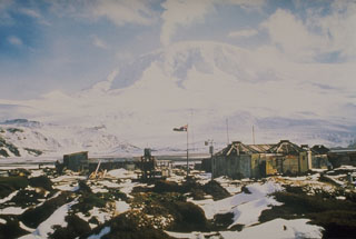
During a private expedition from 22 March to 11 April 2016, scientists and engineers from the 2016 Cordell Expedition documented changes to the island and its life since a prior visit in 1997, and tested radio operations. On 23 March the team was able to photograph the usually cloud-covered Mawson Peak, the summit of Big Ben (figure 24). Steam was visible above the flat upper surface, possibly a crater rim or fissure. They estimated a height of about 45 m of an edifice rising above the adjacent slope. The ground at the site of the team campsite, near Atlas Cove on the NW side of the island, was covered with lava flows (figure 25). While the expedition had to cancel a planned expedition to the summit, rocks collected from the shoreline confirmed the diversity of volcanic rocks on the island (figure 26).
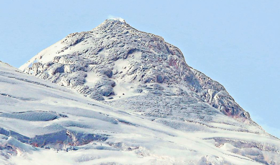 |
Figure 24. Mawson Peak is the summit of Big Ben volcano on Heard Island in the southern Indian Ocean. This photograph, taken on 23 March 2016 from Altas Cove on the NW side of the island by the 2016 Cordell Expedition, shows steam from a possible crater or vent area at the summit, and lava flows covered with a dusting of snow around the otherwise glacier-covered peak. Courtesy of Robert W. Schmieder, 2016 Cordell Expedition, used with permission. |
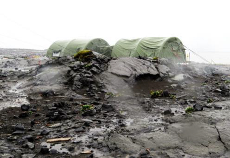 |
Figure 25. Lava flows cover the ground near the 2016 Cordell Expedition campsite at Atlas Cove on the NW side of Heard Island in March 2016. Courtesy of Robert W. Schmieder, 2016 Cordell Expedition, used with permission. |
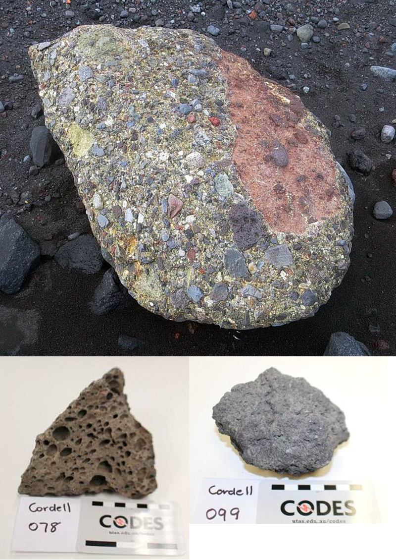 |
Figure 26. Rock samples collected at Heard by the 2016 Cordell Expedition during 23 March-11 April 2016 attest to the volcanic activity of the island. Top: A conglomerate sampled from the east shore of Stephenson Lagoon with mostly volcanic rock fragments, including vesicular basalt (dark brown, lower center) and clasts of volcanic breccia containing fragments of lava (large clast on right side). Sample is about 25 cm long. Bottom: A variety of textures was typical in the volcanic rocks collected on the islands. Courtesy of Robert W. Schmieder, 2016 Cordell Expedition, used with permission. |
At the southern end of Sydney Cove, near Magnet Point on the northern tip of Laurens Peninsula (the NW side of the island), the team identified a small islet, with dimensions of about 40 x 120 m and nearly vertical sides about 100 m high. Columnar jointing in the volcanic rocks is well exposed at the base and on the nearly flat upper surface (figure 27).
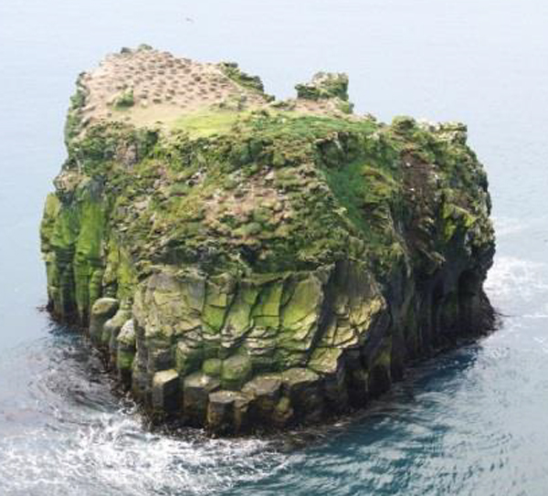 |
Figure 27. Distinctive columnar jointing in the volcanic rocks is visible around the base and on the top of a small islet in Sydney Cove off the NW end of Heard Island in this image taken during the 23 March-11 April 2016 Cordell Expedition. Courtesy of Robert W. Schmieder, 2016 Cordell Expedition, used with permission. |
Satellite thermal and visual data, 2012-2017. The most consistent source of information about eruptive activity at Heard comes from satellite instruments in the form of visual and thermal imagery, and thermal anomaly detection. From the time that renewed activity was detected in MODVOLC data in late September 2012 through September 2017, either the MODVOLC or MIROVA systems have consistently detected thermal signals, with only a few short breaks. A four-month span from mid-July to mid-November 2014, and a two-month gap during February and March 2015 are the only periods longer than a month when no thermal signal was reported. Continuous MIROVA information from late January 2016 through September 2017 shows intermittent but persistent thermal anomalies throughout the period (figure 28).
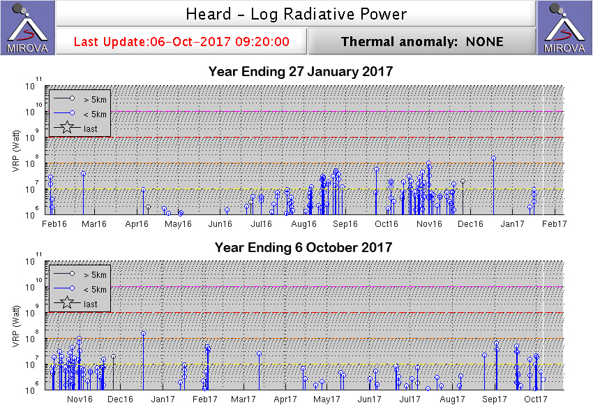 |
Figure 28. A continuous MIROVA signal from 27 January 2016 through 6 October 2017 shows persistent low-level thermal activity through the period with intervals of increased activity during late January 2016, July-August 2016, late September-November 2016, early February 2017, and September 2017. Courtesy of MIROVA. |
The moderate signal at the very end of January 2016 coincides with the CSIRO expedition observing the lava flows on the flank of Big Ben. Low-level MIROVA anomalies were recorded in April and early May 2016. Activity picked up during June, and strengthened through July and August 2016. Late September through November 2016 was a period with heightened activity as well. From December 2016 through August 2017, intermittent low-to-moderate intensity anomalies were recorded every month. Activity appeared to increase briefly during early February and September 2017. On 4 February 2017, Landsat 8 captured a rare clear view that showed fresh lava and debris flows emanating from the summit on top of the snow (figure 29). The longest flow is estimated to be 1,300 m long. False-color infrared imagery of the same image of Mawson Peak also reveals two vents separated by about 250 m (figure 30). Subsequent imagery on 20 and 27 February also detected thermal anomalies at the summit. The visual imagery of the lava flows on 4 February 2017 corresponds to the early February spike in MIROVA thermal anomaly data.
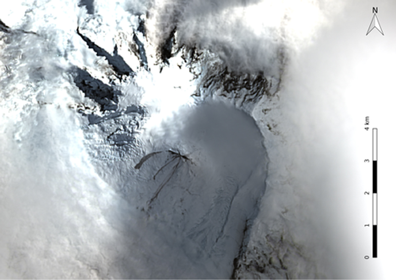 |
Figure 29. Lava and debris flows radiate away from Mawson Peak on Heard Island in this Landsat 8 OLI image captured on 4 February 2017. MIROVA thermal anomaly data show a spike in activity at the same time. Courtesy of NASA and Bill Mitchell (CC-BY). |
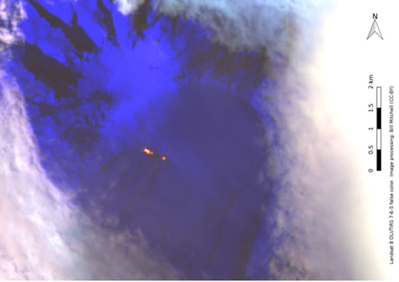 |
Figure 30. False-color infrared imagery of Mawson Peak, Heard Island, 4 February 2017. Two vents are visible in red-yellow, separated by about 250 m. Data source: Landsat 8 OLI/TIRS bands 7-6-5. Image courtesy of Bill Mitchell (CC-BY), data from NASA/USGS. |
Geological Summary. Heard Island on the Kerguelen Plateau in the southern Indian Ocean consists primarily of the emergent portion of two volcanic structures. The large glacier-covered composite basaltic-to-trachytic cone of Big Ben comprises most of the island, and the smaller Mt. Dixon lies at the NW tip of the island across a narrow isthmus. Little is known about the structure of Big Ben because of its extensive ice cover. The active Mawson Peak forms the island's high point and lies within a 5-6 km wide caldera breached to the SW side of Big Ben. Small satellitic scoria cones are mostly located on the northern coast. Several subglacial eruptions have been reported at this isolated volcano, but observations are infrequent and additional activity may have occurred.
Information Contacts: Commonwealth Scientific and Industrial Research Organisation (CSIRO) (URL: http://www.csiro.au/); CSIROscope, CSIRO Blog, Big Ben Erupts: Australia's active volcano cluster blows its lid (URL: https://blog.csiro.au/big-ben-erupts/); Robert W. Schmieder, 2016 Cordell Expedition, 4295 Walnut Blvd., Walnut Creek, CA 94596, Post Expedition report to the Australian Antarctic Division (AAD) (URL: http://www.cordell.org/, http://www.heardisland.org/); MIROVA (Middle InfraRed Observation of Volcanic Activity), a collaborative project between the Universities of Turin and Florence (Italy) supported by the Centre for Volcanic Risk of the Italian Civil Protection Department (URL: http://www.mirovaweb.it/); Hawai'i Institute of Geophysics and Planetology (HIGP) - MODVOLC Thermal Alerts System, School of Ocean and Earth Science and Technology (SOEST), Univ. of Hawai'i, 2525 Correa Road, Honolulu, HI 96822, USA (URL: http://modis.higp.hawaii.edu/); NASA Earth Observatory, EOS Project Science Office, NASA Goddard Space Flight Center, Goddard, Maryland, USA (URL: http://earthobservatory.nasa.gov/); Bill Mitchell, The Inquisitive Rockhopper, Big Ben eruption update 2017-02-27 (URL: https://inquisitiverockhopper.wordpress.com/2017/02/).