Report on Turrialba (Costa Rica) — March 2018

Bulletin of the Global Volcanism Network, vol. 43, no. 3 (March 2018)
Managing Editor: Edward Venzke.
Research and preparation by Paul Berger.
Turrialba (Costa Rica) Persistent explosions and ash emissions continue through 2017; small lava lake
Please cite this report as:
Global Volcanism Program, 2018. Report on Turrialba (Costa Rica) (Venzke, E., ed.). Bulletin of the Global Volcanism Network, 43:3. Smithsonian Institution. https://doi.org/10.5479/si.GVP.BGVN201803-345070
Turrialba
Costa Rica
10.025°N, 83.767°W; summit elev. 3340 m
All times are local (unless otherwise noted)
A phreatic eruption at Turrialba in January 2010 heralded a series of brief eruptions during subsequent years. Explosions and emissions containing ash increased in 2015 and 2016 (BGVN 42:06). The current report indicates that increased activity continued during 2017. The information below comes from the Observatorio Vulcanologico y Sysmologico de Costa Rica-Universidad Nacional (OVSICORI-UNA) unless otherwise indicated.
Frequent ash emissions, both passive and explosive events, rose the heights of less than 1 km above the crater and were blown downwind, causing ashfall in communities within about 40 km, and a sulfur odor at greater distances. Fumarolic plumes described as consisting of water vapor, aerosols, and magmatic gases were also common from the West Crater. Volcanic seismicity was variable, often corresponding to changes in activity.
Activity during January-June 2017. During the first part of January, no explosions took place. Based on webcam and satellite views, the Washington Volcanic Ash Advisory Center (VAAC) reported that on 22 January, an ash plume rose to an altitude of 4 km and drifted E. The VAAC reported ongoing ash emissions on 27 January.
On 1 February, OVSICORI-UNA reported that since 27 January the seismic network had recorded variable-amplitude, discontinuous tremor indicative of moving pressurized volcanic fluid. Passive emissions of ash were observed during 1-2 February, rising as high as 500 m above the crater. Ashfall was reported in the area of the capital, San Jose (about 37 km WSW), including Desamparados, Calle Blancos, and Tres Ríos (27 km WSW), and a sulfur odor was noted in San Pablo Heredia (35 km W). An explosion at 0900 on 4 February generated an ash plume that rose 300 m and drifted W. Almost continuous ash emissions rose at most 500 above the crater during 4-5 February and drifted WSW (figure 48).
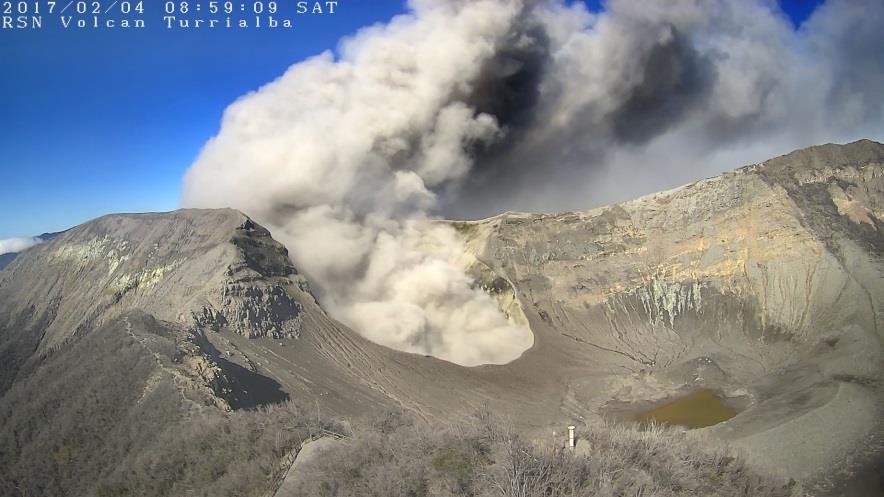 |
Figure 48. An ash explosion from Turrialba on 4 February 2017 at 1145, taken by an RSN camera at the summit. Courtesy of RSN:UCR-ICE (Resumen de la Actividad Sismica y Eruptiva del Volcan Turrialba, 03 de febrero de 2017). |
OVSICORI-UNA reported that at 1610 on 8 February, an ash plume rose 300 m and drifted N. An event at 1531 on 10 February also produced an ash plume, but inclement weather prevented observations. During 11-12 February, variable amplitude tremor was detected, and at night hot blocks ejected from the vent landed in Central Crater. Several events on 13 February (at 0255, 0305, 0415, and 1459) produced ash plumes that rose as high as 1 km and drifted N, NW, and W. Small ejections of incandescent material fell around the active crater during the early morning. On 14 February continuous emissions of gas and steam with low ash content were visible. A strong sulfur odor was reported in San Pablo de Oreamuno (25 km SW). High-amplitude tremor remained constant during 15-16 February and sporadic gas emissions with minor amounts of ash drifted S and E; occasional ballistics were ejected from the crater. During 16-17 February tremor amplitude decreased and sporadic gas emissions with low ash content rose no higher than 300 m and drifted NW and SW. Similar emissions were observed during 20-21 February, drifting NW and NE.
Weak gas emissions during 20-21 March sometimes contained small amounts of ash that rose no higher than 100 m above the crater rim and drifted SW. Volcanic tremor had medium and variable amplitude, and a few low-frequency (LF) earthquakes were recorded. A weak ash emission was visible during 1800-1940 on 25 March. Periods of more intense crater incandescence, from possible Strombolian activity, corresponded to higher tremor amplitude during 0330-0530 on 26 March. Later that day a small plume with minor ash rose 500 m above the crater and drifted S and SE. An event at 0752 on 28 March generated an ash plume that rose 300 m and drifted S.
Ash-and-gas plumes rose 500 m above the crater during 31 March-1 April, and ashfall was reported at the Juan Santamaría airport (48 km W). Ash plumes rose 500 m at 1700 on 2 April, and 200 m at 0601 on 4 April. A passive ash emission occurred on 16 April. An event at 0751 on 17 April generated a plume containing minor amounts of ash that rose 500 m above the crater and drifted SW. On 18 April, a diffuse plume consisting of gas and sometimes ash rose 1 km above the crater and drifted W.
An event at 1700 on 5 May generated a weak ash plume that rose 500 m above the crater and drifted SW. Two short-amplitude events occurred at 1702 and 1820, though it was uncertain if they were associated with an explosion. During 5-7 May volcano-tectonic (VT) and long-period (LP) earthquakes were detected, as well as variable-amplitude tremor. At 1250 on 6 May, an event produced a plume that rose 300 m and drifted W. Passive ash emissions occurred between 1250 and 1730 on 6 May, and at 1000 on 7 May, that rose no higher than 1 km. At 0902 on 9 May an event generated an ash plume that rose 500 m and drifted NW.
An explosion on 10 May was followed by weak and passive ash emissions. Several LP earthquakes were recorded, and inflation continued. Gas measurements indicated a sulfur dioxide flux of 1,000 tonnes/day, and a high carbon dioxide/sulfur dioxide ratio. An event at 0900 on 12 May generated a plume, though poor visibility prevented a height estimate. An event at 0730 on 14 May generated a plume that rose 500 m above the crater rim and drifted N. Low-amplitude tremor was detected during 15-16 May, and a discontinuous ash plume rose no more than 500 m and drifted N and NW.
Ash emissions observed during 17-23 May rose as high as 1 km above the vent. Ashfall was reported in El Tapojo and Juan Viñas (15 km SSE) during 17-18 May, and in Capellades (along with a strong sulfur odor) during 19-20 May. During 23-30 May, tremor amplitude fluctuated from low to high levels, often corresponding to emission characteristics; periods of VT and LP events were also recorded. During 24-26 May several passive ash emissions rose no higher than 500 m above the vent and drifted NW and SW. Frequent and small explosions during 26-27 May generated ash plumes that rose higher than 500 m above the vent and ejected material higher than 200 m and no farther than 100 m towards Central Crater. Small explosions during 27-29 May produced ash plumes that rose 300-500 m. Fumarolic plumes during 30-31 May occasionally contained ash that rose no higher than 300 m above the crater rim and drifted NW.
On 3 June at 1930 an event produced an ash plume that rose 300 m and drifted SW. During 7-13 June, tremor amplitude fluctuated from low to medium levels and periods of small VT events and many small-amplitude LP events were also recorded. Fumarolic plumes rose as high as 1 km above the vent and drifted mainly NW, W, and SW. Gas emissions during 14-15 June sometimes containing ash rose no higher than 300 m above the crater. Events at 0620 and 1405 on 16 June generated ash plumes that rose 500 m and drifted NW, and 200 m and drifted S, respectively. Passive ash emissions during 19-20 June rose as high as 1 km and drifted in multiple directions. During 20-25 June fumarolic plumes rose as high as 1 km above the crater; the gases were strongly incandescent the night of 22-23 June.
Drone observations on 29 June 2017. According to an RSN:UCR-ICE report and meeting abstract (Ruiz and others, 2017), government officials flew a drone over the volcano on 29 June 2017. The observations showed profound changes in the morphology of the active crater since a previous overflight on 30 March 2016. In March 2016, the active crater exhibited internal landslides, an accumulation of materials at the foot of the W wall, and a ring of fumaroles surrounding a small opening that constituted the point of ash emission. The active crater was narrow and had an oblong shape, with a longer axis in the E-W direction.
During the recent overflight, the active crater was deeper and wider, elliptical, with its longest axis in the SW-NE direction, coincident with the preferential direction of explosions. In the N and NE sectors of the crater floor ash and blocks had accumulated. The most significant feature of the crater's central sector was an opening with a major axis of about 50 m across from which incandescent material was observed; the group believed this incandescence originated in the small lava lake from which passive ash emissions or small explosions arise. The authors stated that lava was present on the crater floor, forming a small lava pool (15 x 25 m).
Activity during July-December 2017. During 29 June-11 July seismicity was characterized by low-to-medium amplitude tremor and a small number of low-amplitude VT and LP events. Fumarolic plumes and occasional ash rose as high as 1 km above the West Crater fumaroles. Incandescence from the main crater was recorded at night. Minor ashfall and a sulfur odor was reported in areas of San José including Rancho Redondo, Goicoechea, Moravia, San Pedro Montes de Oca, Guadalupe, and Coronado, and in San Rafael and Barva (Heredia). Parque Nacional Volcán Turrialba staff reported that ash was deposited between La Silvia and La Picada farms. Events at 1325 on 10 July and 1545 on 11 July generated plumes that rose 300 and 500 m above the crater rim, respectively.
Daily explosions over 12-17 July produced gas and ash plumes that rose 200-500 m and generally drifted NW, W, and SW. Multiple events on 15 July caused ashfall in Sabanilla de Montes de Oca (30 km WSW), Ipis (27 km SW), El Carmen de Guadalupe, Purral (26 km WSW), Guadalupe (32 km WSW), and Tibás (35 km WSW). A sulfur dioxide odor was also reported in San José (36 km WSW), Tibás, Guadalupe, Escazú (42 km WSW), and Puriscal (65 km WSW). During 19-24 July fumarolic plumes rose as high as 500 m, and on most nights incandescence emanated from West Crater. The emissions contained ash during 20-22 July; minor ash fell in Coronado (San José) on 20 July, and in Sabanilla de Montes de Oca on 22 July.
Events on 26 July, 9 August (1607), 21 August (1012), 24 August (0715), 28 August (1025), 5 September (0820 and 1550), 11 September (0730), 13 September (0820 and 1555), 14 September (0600), 18 September (0703), 25 September (1112), and 26 September (0910) produced plumes that rose 100-500 m above the crater rim and drifted NW, SW, N, and W.
During 27 September-1 October and on 3 October, daily events generated plumes that rose as high as 1 km above the crater rim and drifted NW, W, SW, and S. On 30 September explosions ejected hot material out of West Crater and minor ashfall was reported in Coronado (San José). On 3 October, ash fell in Santa Cruz (7 km SE), Las Verbenas, Santa Teresita, Calle Vargas, Guayabito, and La Isabel.
Events on 6 October (0815), 9 October (1040), 11 October (0927), and 20 October (0825) produced plumes that rose 50-300 m above the crater rim and drifted NW and N. Events at 1030, 1105, and 1445 on 30 October generated ash plumes that rose 200-500 m above the crater rim and drifted NW, W, and SW. Ashfall was reported in the community of Pacayas (about 12 km SSW).
The Washington VAAC reported that an ash emission was observed in webcam images on 4 November; ash was not identified in satellite images, though weather cloud cover was increasing and may have obscured views. According to OVSICORI-UNA, another ash emission began before 0730 on 13 November and intensified around 0830, generating an ash plume that rose 500 m above the crater rim and drifted SW. A small event at 1319 on 1 December generated a weak ash plume that rose 50 m above the crater rim and drifted SW.
Reference. Ruiz, P., Mora, M., Soto, G.J., Vega, P., Barrantes, R., 2017. Geomorphological mapping using drones into the eruptive summit of Turrialba volcano, Costa Rica. University of Costa Rica. Abstract V23A-0455, AGU Fall meeting of American Geophysical Union, New Orleans, 12 Dec 2017.
Geological Summary. Turrialba, the easternmost of Costa Rica's Holocene volcanoes, is a large vegetated basaltic-to-dacitic stratovolcano located across a broad saddle NE of Irazú volcano overlooking the city of Cartago. The massive edifice covers an area of 500 km2. Three well-defined craters occur at the upper SW end of a broad 800 x 2200 m summit depression that is breached to the NE. Most activity originated from the summit vent complex, but two pyroclastic cones are located on the SW flank. Five major explosive eruptions have occurred during the past 3500 years. A series of explosive eruptions during the 19th century were sometimes accompanied by pyroclastic flows. Fumarolic activity continues at the central and SW summit craters.
Information Contacts: Observatorio Vulcanologico Sismologica de Costa Rica-Universidad Nacional (OVSICORI-UNA), Apartado 86-3000, Heredia, Costa Rica (URL: http://www.ovsicori.una.ac.cr/); Red Sismologica Nacional (RSN) a collaboration between a) the Sección de Sismología, Vulcanología y Exploración Geofísica de la Escuela Centroamericana de Geología de la Universidad de Costa Rica (UCR), and b) the Área de Amenazas y Auscultación Sismológica y Volcánica del Instituto Costarricense de Electricidad (ICE), Costa Rica (URL: http://www.rsn.ucr.ac.cr/); Washington Volcanic Ash Advisory Center (VAAC), Satellite Analysis Branch (SAB), NOAA/NESDIS OSPO, NOAA Science Center Room 401, 5200 Auth Rd, Camp Springs, MD 20746, USA (URL: www.ospo.noaa.gov/Products/atmosphere/vaac, archive at: http://www.ssd.noaa.gov/VAAC/archive.html).