Report on Dukono (Indonesia) — April 2018

Bulletin of the Global Volcanism Network, vol. 43, no. 4 (April 2018)
Managing Editor: Edward Venzke.
Research and preparation by Robert Andrews.
Dukono (Indonesia) Ongoing ash explosions, thermal anomalies, and sulfur dioxide emissions through March 2018
Please cite this report as:
Global Volcanism Program, 2018. Report on Dukono (Indonesia) (Venzke, E., ed.). Bulletin of the Global Volcanism Network, 43:4. Smithsonian Institution. https://doi.org/10.5479/si.GVP.BGVN201804-268010
Dukono
Indonesia
1.6992°N, 127.8783°E; summit elev. 1273 m
All times are local (unless otherwise noted)
The current eruption at Dukono has been ongoing since 1933, with frequent explosions and ash plumes between August 2014 and March 2017 (BGVN 42:06). Similar activity has continued during April 2017-March 2018. Monitoring of the volcano is the responsibility of the Pusat Vulkanologi dan Mitigasi Bencana Geologi (PVMBG), also known as the Center for Volcanology and Geological Hazard Mitigation (CVGHM).
Thermal measurements made by MODIS satellite instruments and processed by MIROVA show regular low-to-moderate thermal anomalies from April to October 2017 (figure 8), but none after December 2017 or in early 2018. MODVOLC analyses of thermal satellite data identified anomalies on 11 April, 29 April, 9 July, 1 August, and 21 August 2017.
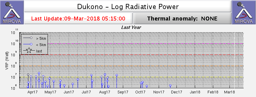 |
Figure 8. Thermal anomalies recorded by the MIROVA system for the year ending 9 March 2018. Courtesy of MIROVA. |
Explosions were frequently reported by both PVMBG and the Darwin Volcanic Ash Advisory Centre (VAAC), with ash plumes rising only a few hundred meters above the Malupang Warirang crater and drifting in various directions (table 17). Some plumes during this reporting period drifted for more than 100 km, with the longest reaching 230 km W on 27 May 2017.
Table 17. Monthly summary of reported ash plumes from Dukono for March 2017-March 2018. The direction of drift for the ash plume through each month is highly variable; only notable significant plumes are listed. Data courtesy of Darwin VAAC and PVMBG.
| Month | Plume Altitude (km) | Notable Plume Drift |
| Apr 2017 | 1.8-2.4 | -- |
| May 2017 | 1.8-2.4 | 230 km W (27 May) |
| Jun 2017 | 1.5-3.0 | 140 km E (07 Jun) |
| Jul 2017 | 1.5-2.7 | -- |
| Aug 2017 | 1.8-2.1 | 150 km (17 Aug) |
| Sep 2017 | 1.5-2.4 | -- |
| Oct 2017 | 1.5-2.1 | 140-170 km (08 Oct) |
| Nov 2017 | 1.8-2.3 | 170 km (04-05 Nov) |
| Dec 2017 | 1.8-2.1 | -- |
| Jan 2018 | 2.1 | -- |
| Feb 2018 | 1.5-2.1 | -- |
| Mar 2018 | 1.5-3.0 | -- |
According to NASA Goddard Space Flight Center, SO2 emissions are commonly detected from Dukono, but usually only at low levels, using the Ozone Monitoring Instrument (OMI) aboard NASA's Earth Observing System (EOS) Aura satellite and the Ozone Mapping and Profiler Suite (OMPS) aboard the NASA/NOAA Suomi National Polar-orbiting Partnership (SNPP) satellite. The strongest emissions captured in satellite data during this report period was on 6 March 2018 (figure 9).
 |
Figure 9. Sulfur dioxide emissions from Dukono can be identified using the Ozone Monitoring Instrument (OMI) on NASA's Aura satellite, as seen in this example from 6 March 2018. The highest amount of SO2 (red) is centered over the volcano. Courtesy of NASA Goddard Space Flight Center. |
Geological Summary. The Dukono complex in northern Halmahera is on an edifice with a broad, low profile containing multiple peaks and overlapping craters. Almost continuous explosive eruptions, sometimes accompanied by lava flows, have occurred since 1933. During a major eruption in 1550 CE, a lava flow filled in the strait between Halmahera and the Gunung Mamuya cone, 10 km NE. Malupang Wariang, 1 km SW of the summit crater complex, contains a 700 x 570 m crater that has also had reported eruptions.
Information Contacts: Pusat Vulkanologi dan Mitigasi Bencana Geologi (PVMBG, also known as Indonesian Center for Volcanology and Geological Hazard Mitigation, CVGHM), Jalan Diponegoro 57, Bandung 40122, Indonesia (URL: http://www.vsi.esdm.go.id/); Darwin Volcanic Ash Advisory Centre (VAAC), Bureau of Meteorology, Northern Territory Regional Office, PO Box 40050, Casuarina, NT 0811, Australia (URL: http://www.bom.gov.au/info/vaac/); Hawai'i Institute of Geophysics and Planetology (HIGP) - MODVOLC Thermal Alerts System, School of Ocean and Earth Science and Technology (SOEST), Univ. of Hawai'i, 2525 Correa Road, Honolulu, HI 96822, USA (URL: http://modis.higp.hawaii.edu/); MIROVA (Middle InfraRed Observation of Volcanic Activity), a collaborative project between the Universities of Turin and Florence (Italy) supported by the Centre for Volcanic Risk of the Italian Civil Protection Department (URL: http://www.mirovaweb.it/); NASA Goddard Space Flight Center (NASA/GSFC), Global Sulfur Dioxide Monitoring Page, Atmospheric Chemistry and Dynamics Laboratory, 8800 Greenbelt Road, Goddard, Maryland, USA (URL: https://so2.gsfc.nasa.gov/).