Report on Bagana (Papua New Guinea) — February 2019

Bulletin of the Global Volcanism Network, vol. 44, no. 2 (February 2019)
Managing Editor: Edward Venzke.
Research and preparation by Sara Arav-Piper.
Bagana (Papua New Guinea) Intermittent ash plumes; thermal anomalies continue through January 2019
Please cite this report as:
Global Volcanism Program, 2019. Report on Bagana (Papua New Guinea) (Venzke, E., ed.). Bulletin of the Global Volcanism Network, 44:2. Smithsonian Institution. https://doi.org/10.5479/si.GVP.BGVN201902-255020
Bagana
Papua New Guinea
6.137°S, 155.196°E; summit elev. 1855 m
All times are local (unless otherwise noted)
The relatively remote Bagana volcano, located on Bougainville Island, Papua New Guinea, is poorly monitored and most of the available data is obtained by satellites (figure 22). The most recent eruptive phase began on or before early 2000 with intermittent ash plumes and detected thermal anomalies (BGVN 41:04, 41:07, 42:08, 43:05). The Darwin Volcanic Ash Advisory Centre (VAAC) monitors satellite imagery for ash plumes that could impact aviation.
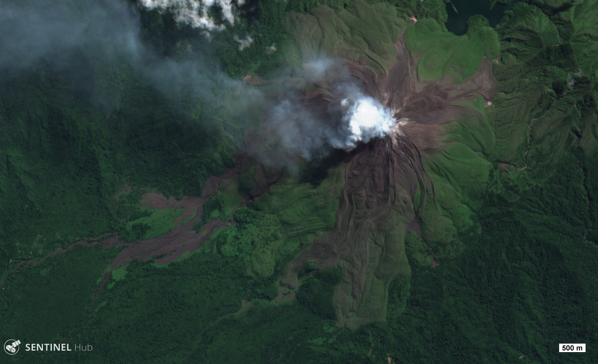 |
Figure 22. Sentinel-2 satellite image (natural color, bands 4, 3, 2) of Bagana on 28 May 2018. Courtesy of Sentinel Hub Playground. |
Cloud cover obscured the volcano during much of the reporting period, but significant ash plumes were identified five times by the Darwin Volcanic Ash Advisory Centre (VAAC), in May, July, and December 2018 (table 6). Infrared satellite imagery from Sentinel-2 frequently showed thermal anomalies, both at the summit and caused by hot material moving down the flanks (figure 23).
Table 6. Summary of ash plumes from Bagana reported during May 2018 through January 2019. Courtesy of the Darwin Volcanic Ash Advisory Centre (VAAC).
| Date | Max Plume Altitude (km) | Plume Drift |
| 08 May 2018 | 2.1 | W |
| 11 May 2018 | 2.1 | SW |
| 22 Jul 2018 | 2.4 | W |
| 29-30 Jul 2018 | 1.8-2.1 | SW |
| 01 Dec 2018 | 3-6.1 | SE |
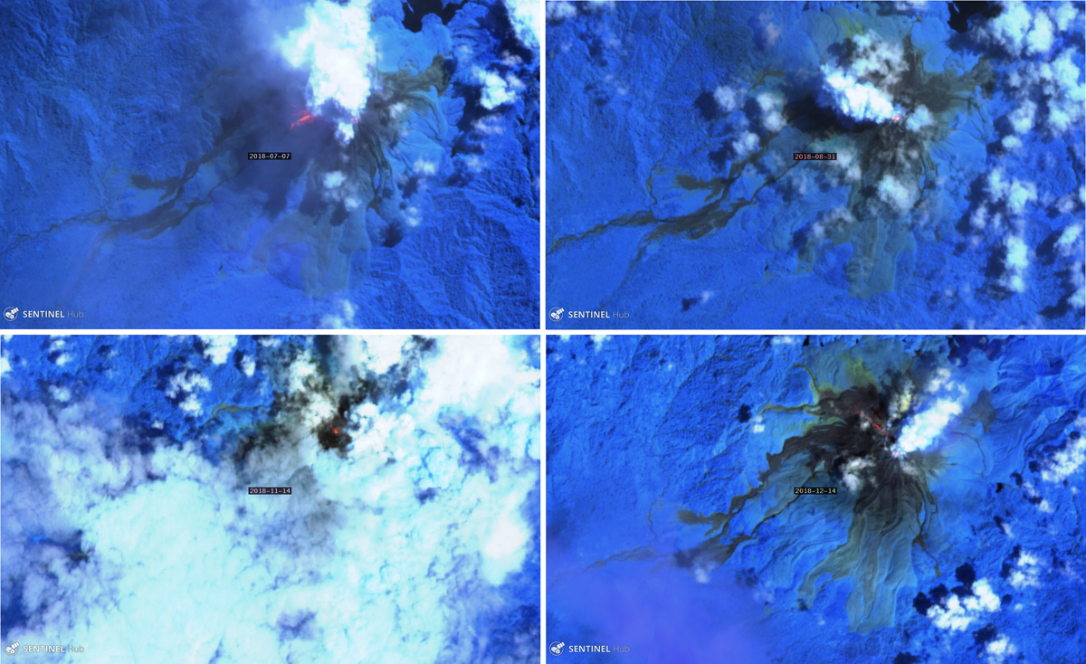 |
Figure 23. Infrared satellite images from Sentinel-2 (atmospheric penetration, bands 12, 11, 8A) showing hot areas at the summit and on the flanks on 7 July (top left), 31 August (top right), 14 November (bottom left) and 14 December (bottom right) 2018. Courtesy of Sentinel Hub Playground. |
The MIROVA (Middle InfraRed Observation of Volcanic Activity) volcano hotspot detection system, recorded a large number of thermal alerts within 5 km of the summit throughout this reporting period (figure 24). Thermal alerts increased in number and intensity beginning mid-July 2018. This pattern is also consistent with the MODVOLC data (also based on MODIS satellite data). A total of 76 thermal anomaly pixels were recorded during the reporting period; of these, greater than 40 pixels were observed during July 2018 alone with 13 pixels reported in December 2018.
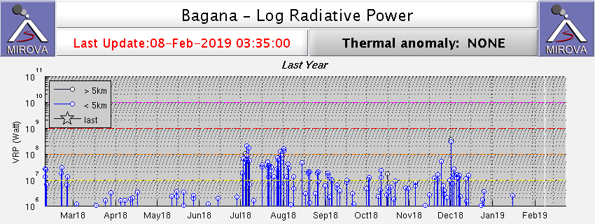 |
Figure 24. Thermal anomalies identified at Bagana by the MIROVA system (log radiative power) for the year ending 8 February 2019. Courtesy of MIROVA. |
Small sulfur dioxide (SO2) anomalies were detected by the AuraOMI instrument during this period, the highest being in the range of 1.5-1.8 Dobson Units (DU). Emissions in this range occurred during 7, 21, and 28 July, and 3-5 and 19 December 2018.
Geological Summary. Bagana volcano, in a remote portion of central Bougainville Island, is frequently active. This massive symmetrical cone was largely constructed by an accumulation of viscous andesitic lava flows. The entire edifice could have been constructed in about 300 years at its present rate of lava production. Eruptive activity is characterized by non-explosive effusion of viscous lava that maintains a small lava dome in the summit crater, although occasional explosive activity produces pyroclastic flows. Lava flows with tongue-shaped lobes up to 50 m thick and prominent levees descend the flanks on all sides.
Information Contacts: Darwin Volcanic Ash Advisory Centre (VAAC), Bureau of Meteorology, Northern Territory Regional Office, PO Box 40050, Casuarina, NT 0811, Australia (URL: http://www.bom.gov.au/info/vaac/); MIROVA, a collaborative project between the Universities of Turin and Florence (Italy) supported by the Centre for Volcanic Risk of the Italian Civil Protection Department (URL: http://www.mirovaweb.it/); Hawai'i Institute of Geophysics and Planetology (HIGP) – MODVOLC Thermal Alerts System, School of Ocean and Earth Science and Technology (SOEST), Univ. of Hawai'i, 2525 Correa Road, Honolulu, HI 96822, USA (URL: http://modis.higp.hawaii.edu/); NASA Goddard Space Flight Center (NASA/GSFC), Global Sulfur Dioxide Monitoring Page, Atmospheric Chemistry and Dynamics Laboratory, 8800 Greenbelt Road, Goddard, Maryland, USA (URL: https://so2.gsfc.nasa.gov/).