Report on Tengger Caldera (Indonesia) — May 2019
Bulletin of the Global Volcanism Network, vol. 44, no. 5 (May 2019)
Managing Editor: Edward Venzke.
Edited by A. Elizabeth Crafford.
Tengger Caldera (Indonesia) New explosions with ash plumes from Bromo Cone mid-February-April 2019
Please cite this report as:
Global Volcanism Program, 2019. Report on Tengger Caldera (Indonesia) (Crafford, A.E., and Venzke, E., eds.). Bulletin of the Global Volcanism Network, 44:5. Smithsonian Institution. https://doi.org/10.5479/si.GVP.BGVN201905-263310
Tengger Caldera
Indonesia
7.942°S, 112.95°E; summit elev. 2329 m
All times are local (unless otherwise noted)
The 16-km-wide Tengger Caldera in East Java, Indonesia is a massive volcanic complex with numerous overlapping stratovolcanos (figure 11). Mount Bromo is a pyroclastic cone that lies within the large Sandsea Caldera at the northern end of the complex (figure 12) and has erupted more than 20 times during each of the last two centuries. It is part of the Bromo Tengger Semeru National Park (also a UNESCO Biosphere Reserve) and is frequently visited by tourists. The last eruption from November 2015 to November 2016 produced hundreds of ash plumes that rose as high as 4 km altitude; some of them drifted for hundreds of kilometers before dissipating and briefly disrupted air traffic. Only steam and gas plumes were observed at Mount Bromo from December 2016 to February 2018 when a new series of explosions with ash plumes began; they are covered in this report with information provided by the Pusat Vulkanologi dan Mitigasi Bencana Geologi (PVMBG, also known as CVGHM) and the Darwin Volcanic Ash Advisory Centre (VAAC). Copyrighted ground and drone-based images from Øystein Lund Andersen have been used with permission of the photographer.
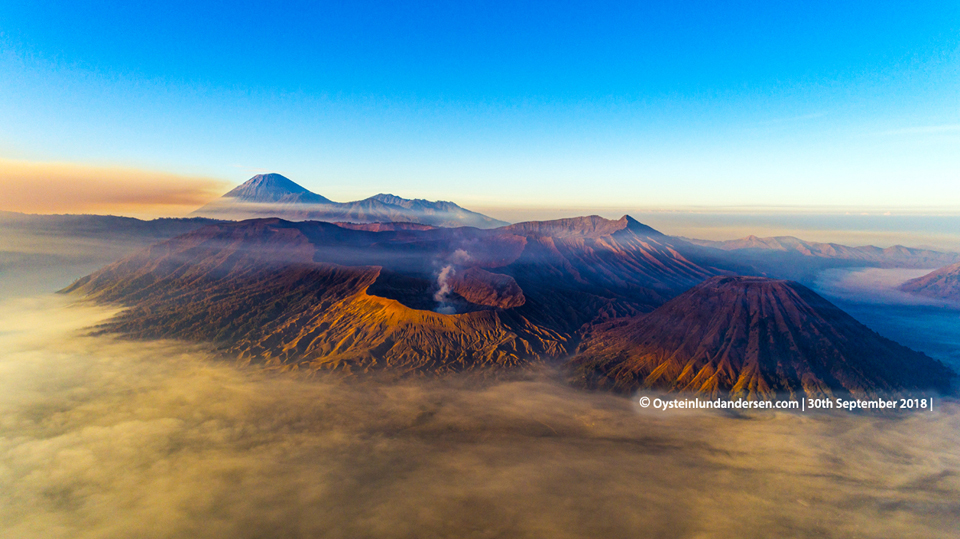 |
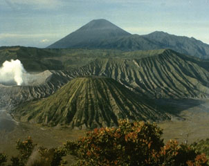
Figure 11. The Tengger Caldera viewed from the north Mount Bromo issuing steam in the foreground and Semeru volcano in the background on 30 September 2018. Courtesy of Øystein Lund Andersen, used with permission. |
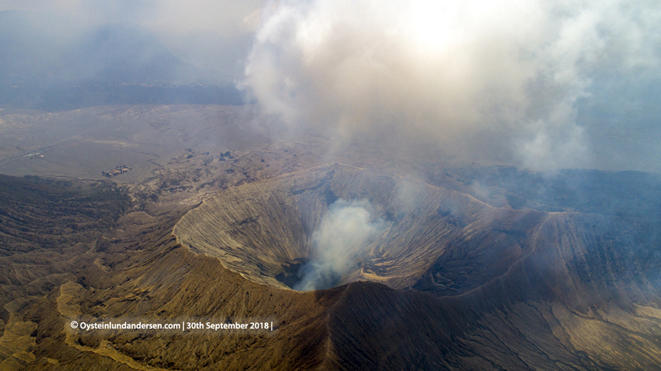 |
Figure 12. Aerial view of the Bromo Cone in Tengger Caldera seen from the west on 30 September 2018. Courtesy of Øystein Lund Andersen, used with permission. |
PVMBG lowered the Alert Level at Bromo on 21 October 2016 from III to II near the end of an eruptive episode lasting nearly a year. The last VAAC report was issued on 12 November 2016 (BGVN 41:12) noting that the last ash emission had been observed the previous day drifting NW at 3 km altitude. Throughout 2017 and 2018 Bromo remained at Alert Level II, with no unusual activity described by PVMBG. During 1-2 September 2018, a wildfire in the Bromo Tengger Semeru National Park burned 65 hectares of savannah (figure 13); the fire produced 12 MODVOLC thermal alerts around the Tengger Caldera rim. No reports of increased volcanic activity were issued by PVMBG during the period.
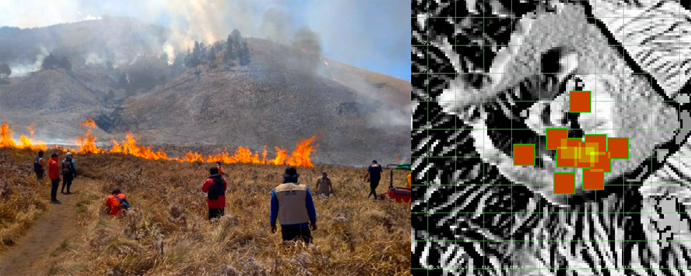 |
Figure 13. A wall of fire in the Bromo Tengger Semeru National Park savanna during 1-2 September 2018 produced thermal alerts that were not related to volcanic activity at the Bromo Cone in Tengger Caldera. Image courtesy of the park authority, reported by Mongabay. MODVOLC thermal alerts courtesy of Hawai'i Institute of Geophysics and Planetology (HIGP). |
After slightly more than two years of little activity other than gas and steam plumes, ash emissions resumed from the Bromo Cone on 18 February 2019. After a brief pause, a new explosion on 10 March marked the beginning of a series of near-daily ash emissions that lasted for the rest of March, producing ash plumes that rose to altitudes ranging from 3.0 to 5.2 km and drifted in many different directions. A new series of ash emissions began on 6 April, rising to 3 km and also drifting in multiple directions. Ash emission density decreased during the month; plumes were only rising a few hundred meters above the summit by the end of April and consisted of mostly steam and moderate amounts of ash.
Activity during February-April 2019. PVMBG reported that at 0600 on 18 February 2019 an eruption at Tengger Caldera's Bromo Cone generated a dense white-and-brown ash plume that rose 600 m and drifted WSW. The plume was not visible in satellite imagery, according to the Darwin VAAC. The Alert Level remained at 2 (on a scale of 1-4). After a few weeks of quiet a new explosion on 10 March (local time) produced a white, brown, and gray ash plume that rose 600 m above the summit; the plume was visible in satellite imagery extending SW. Increased tremor amplitude was also reported on 10 March. A new emission the next morning produced similar ash plumes that drifted S, SW, and W at 3 km altitude. On the morning of 12 March (local time) a continuous ash plume was observed in satellite imagery at 3.4 km altitude drifting SW. The plume drifted counterclockwise towards the S, E, and NE throughout the day and continued to drift NE and SE on 13 March. The altitude of the plume was reported at 4.3 km later that day based on a pilot report.
Continuous brown, gray, and black ash emissions were reported by PVMBG during 14-19 March at altitudes ranging from 3 to 3.9 km; they drifted generally NE to NW. Ashfall was noted around the crater and downwind a short distance. The Darwin VAAC reported continuous ash emissions to 5.2 km altitude drifting SE on 20 March. It was initially reported by a pilot and partially discernable in satellite imagery before dissipating. Ongoing ash emissions of variable densities and colors ranging from white to black were intermittently visible in satellite imagery and confirmed in webcam and ground reports at around 3.0 km altitude during 21-25 March (figures 14-17). Ashfall impacted the closest villages to Bromo, including Cemara Lawang (30 km NW), which was covered by a thin layer of ash. A few trees in the area were toppled over by the weight of the ash. The plume altitude increased slightly on 26 March to 3.7-3.9 km, drifting N and NE. The higher altitude plume dissipated early on 28 March, but ash emissions continued at 3.0 km for the rest of the day.
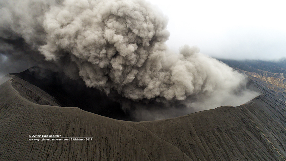 |
Figure 14. Ash drifted NNE from the Bromo Cone in Tengger Caldera on 23 March 2019. Courtesy of Øystein Lund Andersen (drone image), used with permission. |
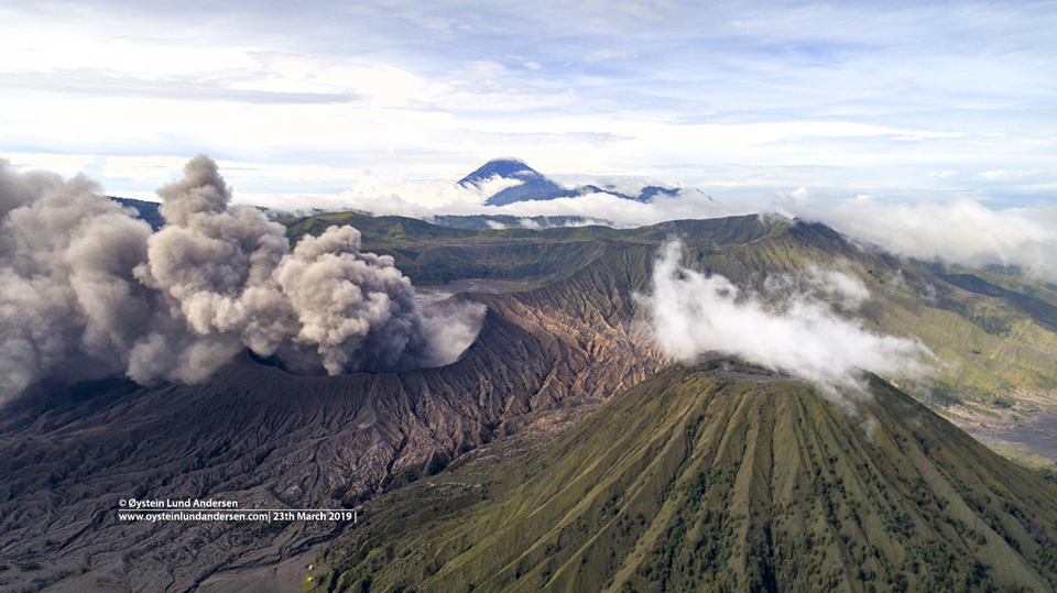 |
Figure 15. Ash drifted N from the Bromo Cone in Tengger Caldera on 23 March 2019. The Batok Cone is on the right, Segera Wedi is behind Bromo, and Semeru is in the far background. Courtesy of Øystein Lund Andersen, used with permission. |
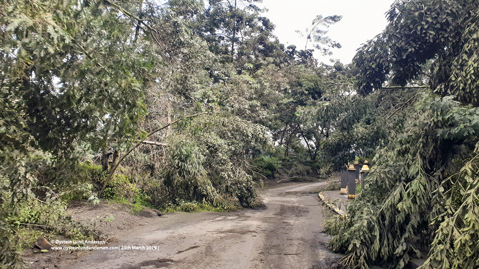 |
Figure 16. A few trees toppled from ashfall in the vicinity of the Bromo Cone in Tengger Caldera on 24 March 2019. Courtesy of Øystein Lund Andersen, used with permission. |
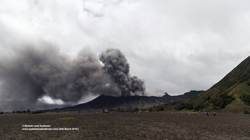 |
Figure 17. Ash plumes from the Bromo Cone in Tengger Caldera on 24 March 2019 caused ashfall in communities as far as 30 km away. View is from the floor of the Sandsea Caldera. Courtesy of Øystein Lund Andersen, used with permission. |
After just a few days of quiet, new ash emissions rising to 3.0 km altitude and drifting SE were reported by both PVMBG (from the webcam) and the Darwin VAAC on 6 April 2019. By the next day the continuous ash emissions were drifting N, then E during 8-10 April, and S during 11 and 12 April. A new emission seen in the webcam was reported by the Darwin VAAC on 15 April (UTC) that rose to 3.0 km and drifted W. Ash plumes were intermittently visible in either webcam or satellite imagery until 17 April rising 500-1,000 m above the crater; from 19-25 April only steam plumes were reported rising 300-500 m above the summit. A minor ash emission was reported from the webcam on 26 April that rose to 3.0 km altitude and drifted NE for a few hours before dissipating. PVMBG reported medium density white to gray ash plumes that rose 400-600 m above the crater for the remainder of the month.
Geological Summary. The 16-km-wide Tengger caldera is located at the northern end of a volcanic massif extending from Semeru volcano. The massive volcanic complex dates back to about 820,000 years ago and consists of five overlapping stratovolcanoes, each truncated by a caldera. Lava domes, pyroclastic cones, and a maar occupy the flanks of the massif. The Ngadisari caldera at the NE end of the complex formed about 150,000 years ago and is now drained through the Sapikerep valley. The most recent of the calderas is the 9 x 10 km wide Sandsea caldera at the SW end of the complex, which formed incrementally during the late Pleistocene and early Holocene. An overlapping cluster of post-caldera cones was constructed on the floor of the Sandsea caldera within the past several thousand years. The youngest of these is Bromo, one of Java's most active and most frequently visited volcanoes.
Information Contacts: Pusat Vulkanologi dan Mitigasi Bencana Geologi (PVMBG, also known as Indonesian Center for Volcanology and Geological Hazard Mitigation, CVGHM), Jalan Diponegoro 57, Bandung 40122, Indonesia (URL: http://www.vsi.esdm.go.id/); Darwin Volcanic Ash Advisory Centre (VAAC), Bureau of Meteorology, Northern Territory Regional Office, PO Box 40050, Casuarina, NT 0811, Australia (URL: http://www.bom.gov.au/info/vaac/); Hawai'i Institute of Geophysics and Planetology (HIGP) - MODVOLC Thermal Alerts System, School of Ocean and Earth Science and Technology (SOEST), Univ. of Hawai'i, 2525 Correa Road, Honolulu, HI 96822, USA (URL: http://modis.higp.hawaii.edu/); Øystein Lund Andersen (Twitter: @OysteinLAnderse, https://twitter.com/OysteinLAnderse, URL: http://www.oysteinlundandersen.com); Mongabay, URL: https://news.mongabay.com/2018/09/fires-tear-through-east-java-park-threatening-leopard-habitat/.